Items Similar to Antique Map of Southern Zeeland by Von Reilly, 1790

Want more images or videos?
Request additional images or videos from the seller
1 of 5
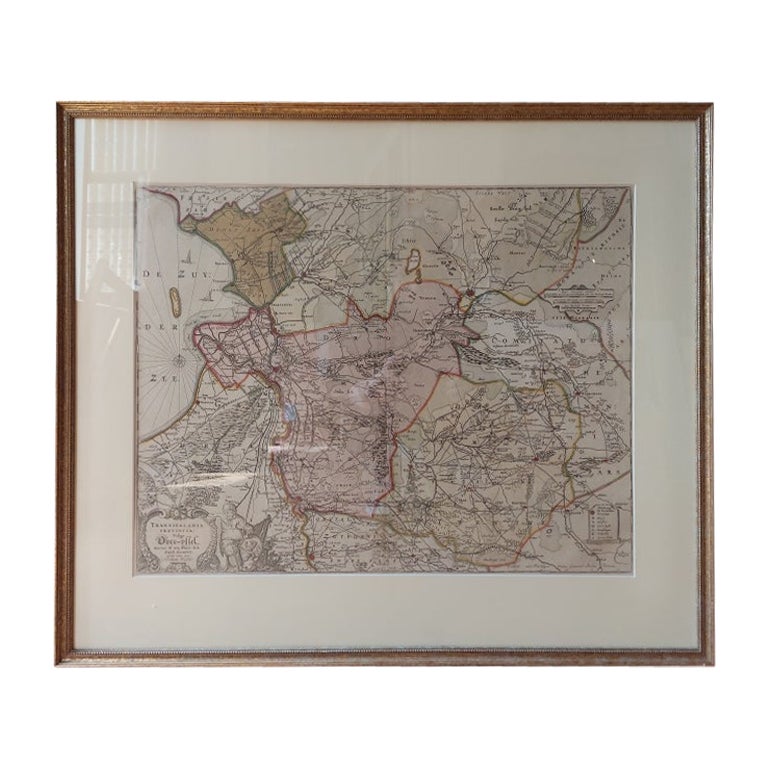
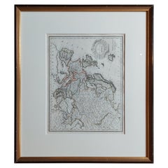
Antique Map of Southern Zeeland by Von Reilly, 1790
$189.79
$237.2320% Off
£141.28
£176.6020% Off
€158.40
€19820% Off
CA$259.96
CA$324.9520% Off
A$289.13
A$361.4120% Off
CHF 150.98
CHF 188.7220% Off
MX$3,518.42
MX$4,398.0320% Off
NOK 1,928.19
NOK 2,410.2320% Off
SEK 1,808.30
SEK 2,260.3720% Off
DKK 1,205.84
DKK 1,507.3020% Off
Shipping
Retrieving quote...The 1stDibs Promise:
Authenticity Guarantee,
Money-Back Guarantee,
24-Hour Cancellation
About the Item
"Antique map titled 'Seelands südlicher Theil oder die Inseln Süd Beverland, Tholen, Wolfersdyk und S. Philipsland'. Original antique map of the southern portion of the province of Zeeland including Zuid-Beveland, Tholen en Sint Philipsland, the Netherlands. From 'Schauplatz Der Funf Theile der Welt' (Wien: Reilly, 1791-1806), a world atlas in 830 maps by Franz Joseph Johann von Reilly. Artists and Engravers: Franz Joseph Johann von Reilly (1766-1820) was a Vienna based art dealer. He is also known as the author of two atlases.
Artist: Franz Joseph Johann von Reilly (1766-1820) was a Vienna based art dealer. He is also known as the author of two atlases.
Condition: Good, general age-related toning. Frame included, minor wear. Please study image carefully.
Date: 1790
Overall size: 46.2 x 42.8 cm.
Image size: 0.001 x 26.5 x 21.5 cm.
Antique prints have long been appreciated for both their aesthetic and investment value. They were the product of engraved, etched or lithographed plates. These plates were handmade out of wood or metal, which required an incredible level of skill, patience and craftsmanship. Whether you have a house with Victorian furniture or more contemporary decor an old engraving can enhance your living space. We offer a wide range of authentic antique prints for any budget.".
- Dimensions:Height: 16.86 in (42.8 cm)Width: 18.19 in (46.2 cm)Depth: 0 in (0.01 mm)
- Materials and Techniques:
- Period:
- Date of Manufacture:1790
- Condition:
- Seller Location:Langweer, NL
- Reference Number:Seller: BG-115361stDibs: LU3054327662932
About the Seller
5.0
Recognized Seller
These prestigious sellers are industry leaders and represent the highest echelon for item quality and design.
Platinum Seller
Premium sellers with a 4.7+ rating and 24-hour response times
Established in 2009
1stDibs seller since 2017
2,510 sales on 1stDibs
Typical response time: <1 hour
- ShippingRetrieving quote...Shipping from: Langweer, Netherlands
- Return Policy
Authenticity Guarantee
In the unlikely event there’s an issue with an item’s authenticity, contact us within 1 year for a full refund. DetailsMoney-Back Guarantee
If your item is not as described, is damaged in transit, or does not arrive, contact us within 7 days for a full refund. Details24-Hour Cancellation
You have a 24-hour grace period in which to reconsider your purchase, with no questions asked.Vetted Professional Sellers
Our world-class sellers must adhere to strict standards for service and quality, maintaining the integrity of our listings.Price-Match Guarantee
If you find that a seller listed the same item for a lower price elsewhere, we’ll match it.Trusted Global Delivery
Our best-in-class carrier network provides specialized shipping options worldwide, including custom delivery.More From This Seller
View AllAntique Map of Overijssel by Visscher, c.1660
Located in Langweer, NL
Antique map titled 'Transisalania provincia vulgo Over-yssel'. Original antique map of the province of Overijssel, the Netherlands. Published by N. Visscher after N. ten Have, circa ...
Category
Antique 17th Century Maps
Materials
Paper

$707 Sale Price
20% Off
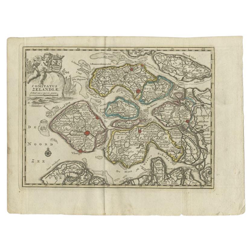
Antique Map of the Province of Zeeland by Keizer & De Lat, 1788
Located in Langweer, NL
Antique map titled 'Comitatus Zelandiae'. Uncommon antique map of the province of Zeeland, the Netherlands. This map originates from 'Nieuwe Natuur- Geschied- en Handelkundige Zak- e...
Category
Antique 18th Century Maps
Materials
Paper
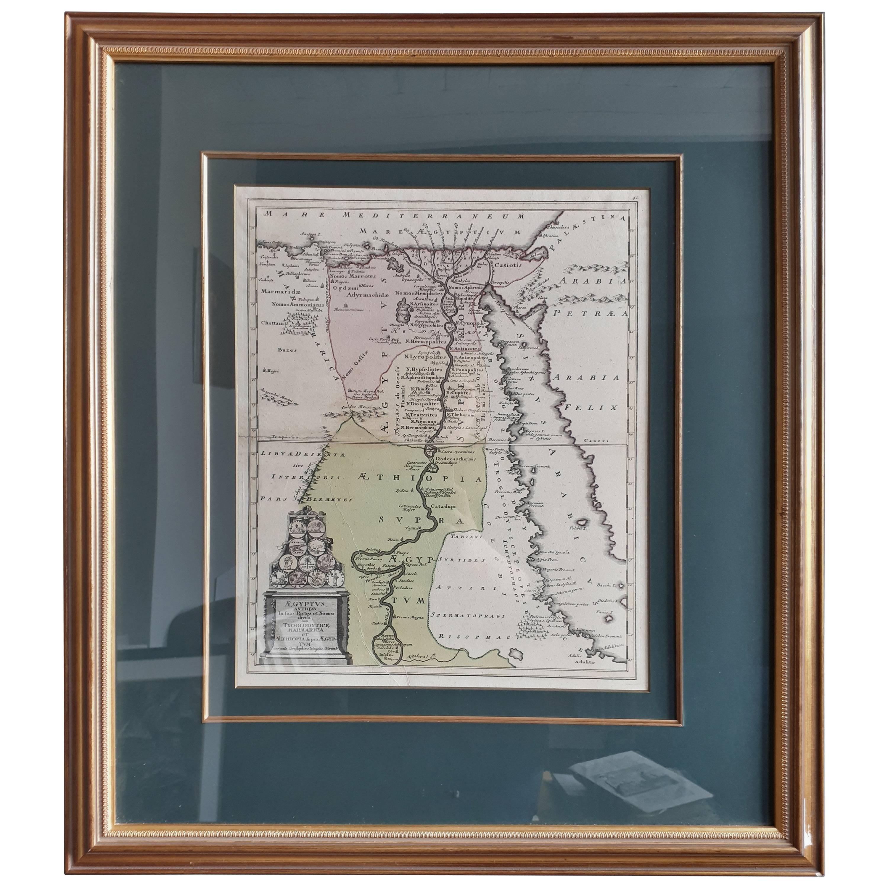
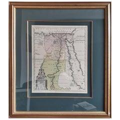
Original Antique Map of Egypt in Frame by C. Weigel, circa 1720
Located in Langweer, NL
The map is an antique depiction of ancient Egypt, divided into its regions and nomes, also including areas like Troglodytica, Marmarica, and Ethiopia above Egypt. Christophorus Weige...
Category
Antique Early 18th Century Maps
Materials
Paper
$934 Sale Price
20% Off
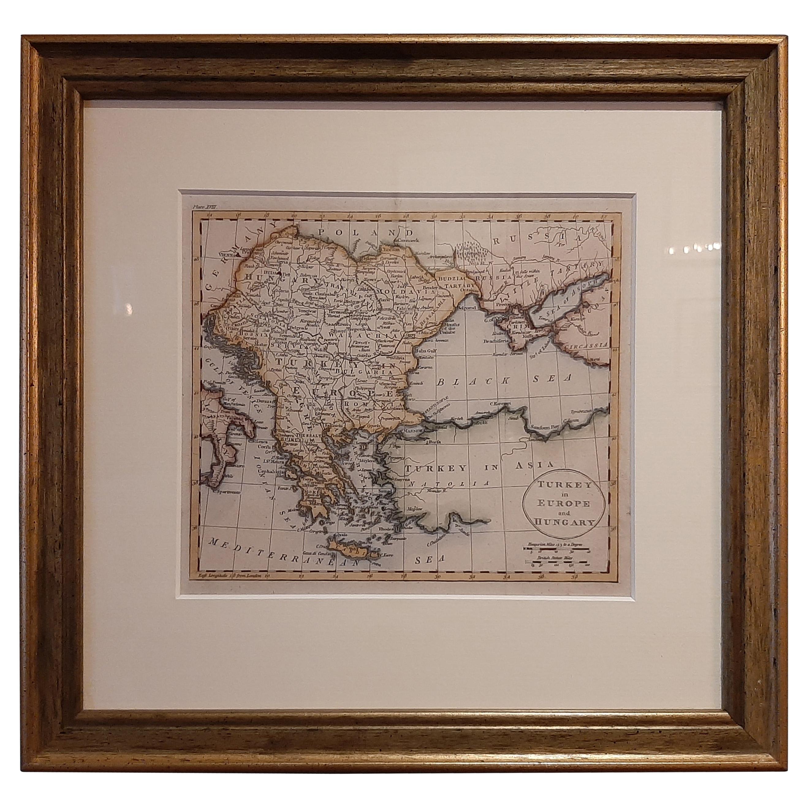
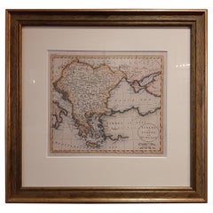
Antique Map of Turkey in Europe by Russell, circa 1795
Located in Langweer, NL
Antique map titled 'Turkey in Europe and Hungary'. Original map of Turkey in Europe. Covers present day Northern Turkey, Greece, Albania, Romania, Hungary, Croatia, Bosnia Herzogovin...
Category
Antique Late 18th Century Maps
Materials
Paper
$335 Sale Price
20% Off
Antique Map of Overijssel by Van Jagen, 1771
Located in Langweer, NL
Antique map titled 'L'Over-Issel'. This map depicts the Dutch province Overijssel. This map originates from 'Nouvel Atlas, très exact et fort commode pour toutes sortes de personnes,...
Category
Antique 18th Century Maps
Materials
Paper

$182 Sale Price
20% Off
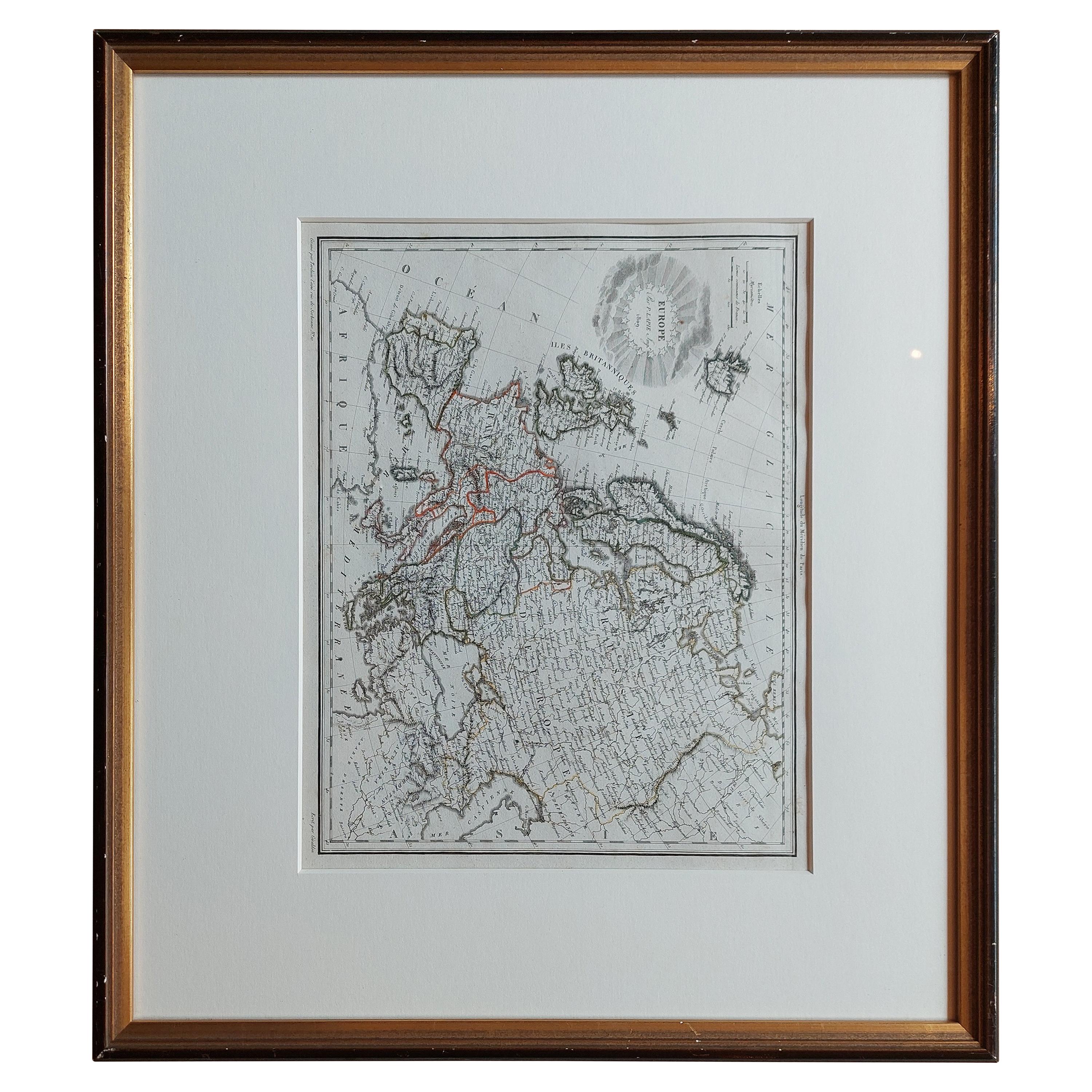
Antique Map of Europe by Lapie, '1809'
Located in Langweer, NL
Antique map titled 'Europe'. Original antique map of Europe by P. Lapie, published 1809. Frame included.
Category
Antique Early 19th Century Maps
Materials
Paper
$287 Sale Price
20% Off
You May Also Like
Map Lancashire 1793 John Cary engraver 37cm 14 1/2" high
Located in BUNGAY, SUFFOLK
Map of Lancashire by John Cary engraver
published 1st Jan 1793 by J Cary Engraver & Mapseller Strand
in original black and gold classic map frame
Category
Antique 18th Century English Georgian Maps
Materials
Paper

Antique Lithography Map, West Africa, English, Framed, Cartography, Victorian
Located in Hele, Devon, GB
This is an antique lithography map of Western Africa. An English, framed atlas engraving of cartographic interest by John Rapkin, dating to the early Victorian period and later, circ...
Category
Antique Mid-19th Century British Early Victorian Maps
Materials
Wood

Antique Lithography Map, Black Sea, English, Framed, Cartography, Victorian
Located in Hele, Devon, GB
This is an antique lithography map of the Black Sea region. An English, framed atlas engraving of cartographic interest by John Rapkin, dating to the early Victorian period and later...
Category
Antique Mid-19th Century British Early Victorian Maps
Materials
Wood

Vintage Reproduction 17th Century Map of Europe, American, Cartography, Blaeuw
Located in Hele, Devon, GB
This is a vintage reproduction map of Europe. An American, paper stock cartography print in frame after the work by Blaeuw, dating to the late 20t...
Category
Late 20th Century Central American Mid-Century Modern Maps
Materials
Glass, Wood, Paper

Framed 17th Century Map of Cumberland, England by John Speed, 1610
By John Speed
Located in Middleburg, VA
A fascinating and richly detailed antique map of Cumberland County in northwest England, drawn and published by the celebrated English cartographer John Spe...
Category
Antique Early 17th Century English British Colonial Maps
Materials
Copper, Gold Leaf

Antique Lithography Map, Bedfordshire, English, Framed Engraving, Cartography
Located in Hele, Devon, GB
This is an antique lithography map of Bedfordshire. An English, framed atlas engraving of cartographic interest, dating to the mid 19th century and...
Category
Antique Mid-19th Century British Victorian Maps
Materials
Wood

More Ways To Browse
Furniture From 1790
Vienna 18th
Franz Joseph
Ipswich Antique Furniture
Maps Balkans
Missouri Map
Antique Maps Of Texas
Antique Maps Virginia
Antique Railroad Scale
Jamaican Antique
Hindeloopen Furniture
Romania Map
Stanford Antique Furniture
Sardinia Map
Victorian Staircase
Nantucket Map
Afghanistan Antique Map
Antique Map Of Hawaii