Items Similar to Antique Plan of the Siege of Grave by Guicciardini, c.1608


Want more images or videos?
Request additional images or videos from the seller
1 of 6
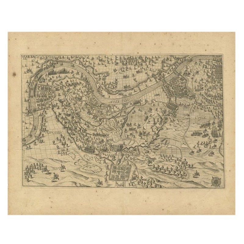
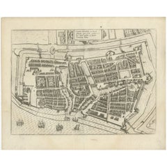
Antique Plan of the Siege of Grave by Guicciardini, c.1608
$453.68
$567.1020% Off
£340.06
£425.0720% Off
€384
€48020% Off
CA$623.28
CA$779.1020% Off
A$695.83
A$869.7920% Off
CHF 364.60
CHF 455.7620% Off
MX$8,517.63
MX$10,647.0420% Off
NOK 4,630.48
NOK 5,788.0920% Off
SEK 4,365.95
SEK 5,457.4420% Off
DKK 2,923.15
DKK 3,653.9420% Off
Shipping
Retrieving quote...The 1stDibs Promise:
Authenticity Guarantee,
Money-Back Guarantee,
24-Hour Cancellation
About the Item
Antique map titled 'Hic est situs oppidi Grauiae (..)'. Bird's eye view plan of Grave, The Netherlands, Holland. Showing the siege of Grave in the year 1602. Source unknown, to be determined.
Artists and Engravers: Lodovico Guicciardini (19 August 1521 – 22 March 1589) was an Italian writer and merchant from Florence who lived primarily in Antwerp from 1542 or earlier. He was the nephew of historian and diplomat Francesco Guicciardini.
Condition: Very good, given age. Some browning but only visible in the margins and on verso. Original middle fold as issued. General age-related toning and/or occasional minor defects from handling. Please study image carefully.
Date: c.1608
Overall size: 37.9 x 29.2 cm.
Image size: 33.8 x 24.4 cm.
We sell original antique maps to collectors, historians, educators and interior decorators all over the world. Our collection includes a wide range of authentic antique maps from the 16th to the 20th centuries. Buying and collecting antique maps is a tradition that goes back hundreds of years. Antique maps have proved a richly rewarding investment over the past decade, thanks to a growing appreciation of their unique historical appeal. Today the decorative qualities of antique maps are widely recognized by interior designers who appreciate their beauty and design flexibility. Depending on the individual map, presentation, and context, a rare or antique map can be modern, traditional, abstract, figurative, serious or whimsical. We offer a wide range of authentic antique maps for any budget.
- Dimensions:Height: 11.5 in (29.2 cm)Width: 14.93 in (37.9 cm)Depth: 0 in (0.01 mm)
- Materials and Techniques:
- Period:
- Date of Manufacture:circa 1608
- Condition:Condition: Very good, given age. Some browning but only visible in the margins and on verso. Original middle fold as issued. General age-related toning and/or occasional minor defects from handling. Please study image carefully.
- Seller Location:Langweer, NL
- Reference Number:Seller: PC-58903'1stDibs: LU3054329264992
About the Seller
5.0
Recognized Seller
These prestigious sellers are industry leaders and represent the highest echelon for item quality and design.
Platinum Seller
Premium sellers with a 4.7+ rating and 24-hour response times
Established in 2009
1stDibs seller since 2017
2,513 sales on 1stDibs
Typical response time: <1 hour
- ShippingRetrieving quote...Shipping from: Langweer, Netherlands
- Return Policy
Authenticity Guarantee
In the unlikely event there’s an issue with an item’s authenticity, contact us within 1 year for a full refund. DetailsMoney-Back Guarantee
If your item is not as described, is damaged in transit, or does not arrive, contact us within 7 days for a full refund. Details24-Hour Cancellation
You have a 24-hour grace period in which to reconsider your purchase, with no questions asked.Vetted Professional Sellers
Our world-class sellers must adhere to strict standards for service and quality, maintaining the integrity of our listings.Price-Match Guarantee
If you find that a seller listed the same item for a lower price elsewhere, we’ll match it.Trusted Global Delivery
Our best-in-class carrier network provides specialized shipping options worldwide, including custom delivery.More From This Seller
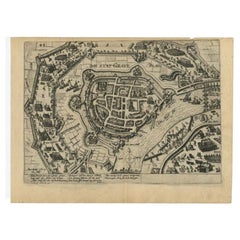
View AllAntique Plan of Grave, The Netherlands, Showing the Siege of Grave in 1602
Located in Langweer, NL
Antique map titled 'Die Stat Grave' Bird's eye view plan of Grave, The Netherlands, Holland. Showing the siege of Grave in the year 1602 by Prince Maurits of The Netherlands. Source ...
Category
Antique 16th Century Maps
Materials
Paper
$415 Sale Price
20% Off
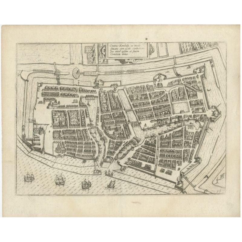
Antique Plan of Emden in Germany by Guicciardini, 1612
Located in Langweer, NL
Antique map Emden titled 'Civitas Embda, eo modo situata cum essit controversia inter ipsam et suum Comitem anno'. Small plan of the city of Emden, Germany, Also depicted is part of ...
Category
Antique 17th Century Maps
Materials
Paper
$359 Sale Price
20% Off
Antique Map of Douai 'France' by Braun & Hogenberg, circa 1575
Located in Langweer, NL
Beautiful map in excellent condition. This map depicts the city of Douai (France) and originates from 'Civitates Orbis Terrarum'.
Category
Antique 16th Century Maps
Materials
Paper

Antique Map of the Region of Grave by Orlers, 1615
Located in Langweer, NL
Antique map of the region of Grave, also including Cuijk and Ravestein. This map originates from 'La genealogie des illustres Comtes de Nassau' by Jan Jansz. Orlers.
Artists and E...
Category
Antique 17th Century Maps
Materials
Paper
$151 Sale Price
20% Off
Antique Map of The Siege of Gennep, the Netherlands, c.1650
Located in Langweer, NL
Antique map titled 'Belagerung des Besten Schloss und Passes Gennep'. Old map of the Siege of Gennep, the Netherlands. This map originates from 'Theatrum Europaeum' by M. Merian. Art...
Category
Antique 17th Century Maps
Materials
Paper

$226 Sale Price
20% Off
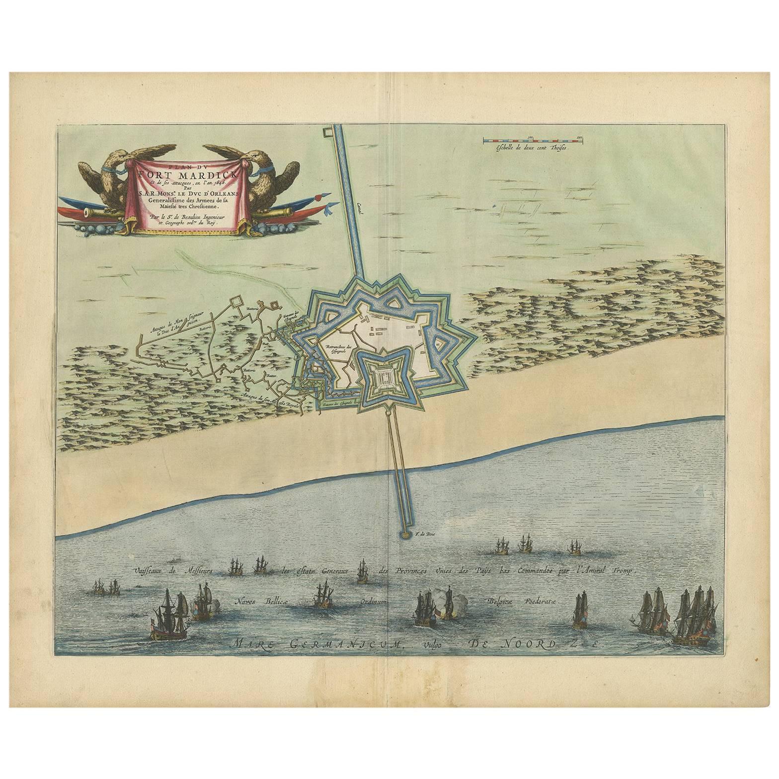
Antique Plan of Fort Mardyck Mardijk, France by S. Beaulieu, 1649
Located in Langweer, NL
Plan of Fort Mardyck (Fort Mardijk) and surroundings by Sébastian de Pontault Beaulieu. Mardyck is a former commune in the Nord department in northern France. It is an associated com...
Category
Antique Mid-17th Century Maps
Materials
Paper

$505 Sale Price
20% Off
You May Also Like
17th-18th Century Siege of Graves Mapping Engraving By Willian III
Located in Kingston, NY
RARE French 17th-18th Century Enhanced Siege of Graves Mapping Engraving BY William III, also widely known as William of Orange,
The Siege of Grave in Dutch Brabant started by Monsie...
Category
Antique 17th Century French Prints
Materials
Paper

17th Century Toulouse, Savve, Sommieres Topographical Map by Iohan Peeters
Located in New York, NY
Fine topographical 17th century map of Toulouse, Savve and Sommieres by Iohan Peeters
Beautiful engraving of the capital of France's Occitanie Region, Toulouse, called La Ville Rose- the Pink City, for the terracotta bricks used in its many buildings, giving the city a distinct apricot-rose hue. An important cultural and educational center, the city's residents included Nobel Prize winners and world renown artists- Henri de Toulouse-Lautrec, Henri Martin, Jean-Auguste-Dominique Ingres, Antonin Mercie, Alexandre Falguiere and more recently Cyril Kongo...
Category
Antique 17th Century Dutch Maps
Materials
Paper

1657 Janssonius Map of Vermandois and Cappelle, Ric. A-004
Located in Norton, MA
1657 Janssonius map of
Vermandois and Cappelle
Ric.a004
Description: Antique map of France titled 'Descriptio Veromanduorum - Gouvernement de la Cappelle'. Two detailed maps o...
Category
Antique 17th Century Unknown Maps
Materials
Paper

1633 Map Entitled "Beauvaisis Comitatus Belova Cium, Ric.0002
Located in Norton, MA
1633 map entitled
"Beauvaisis Comitatus Belova Cium,"
Hand Colored
Ric.0002
Description: Cartographer : - Hondius, Henricus 1587-1638
Artists and Engravers:Jodocus Hondius, one of the most notable engravers of his time. He is known for his work in association with many of the cartographers and publishers prominent at the end of the sixteenth and the beginning of the seventeenth century. A native of Flanders, he grew up in Ghent, apprenticed as an instrument and globe maker and map engraver. In 1584, to escape the religious troubles sweeping the Low Countries at that time, he fled to London where he spent some years before finally settling in Amsterdam about 1593. In the London period he came into contact with the leading scientists and geographers of the day and engraved maps in The Mariner\\\\\\\\\\\\\\\'s Mirrour, the English edition of Waghenaer\\\\\\\\\\\\\\\'s Sea Atlas, as well as others with Pieter van den Keere, his brother-in-law. No doubt his temporary exile in London stood him in good stead, earning him an international reputation, for it could have been no accident that Speed chose Hondius to engrave the plates for the maps in The Theatre of the Empire of Great Britaine in the years between 1605 and 1610. In 1604 Hondius bought the plates of Mercator\\\\\\\\\\\\\\\'s Atlas which, in spite of its excellence, had not competed successfully with the continuing demand for the Ortelius Theatrum Orbis Terrarum. To meet this competition Hondius added about 40 maps to Mercator\\\\\\\\\\\\\\\'s original number and from 1606 published enlarged editions in many languages, still under Mercator\\\\\\\\\\\\\\\'s name but with his own name as publisher. These atlases have become known as the Mercator/Hondius series. The following year the maps were reengraved in miniature form and issued as a pocket Atlas Minor. After the death of Jodocus Hondius the Elder in 1612, work on the two atlases, folio and miniature, was carried on by his widow and sons, Jodocus II and Henricus, and eventually in conjunction with Jan Jansson in Amsterdam.
In all, from 1606 onwards, nearly 50 editions with increasing numbers of maps with texts in the main European languages were printed. Summaries of these issues are given under the entry for Gerard Mercator. Jodocus Hondius the Elder * 1588 Maps in The Mariner\\\\\\\\\\\\\\\'s Mirrour (Waghenaer/Ashley) * 1590 World Map...
Category
Antique 17th Century Dutch Maps
Materials
Paper

1630 Pierre Petit map "Description du Gouvernement de la Capelle" Ric0010
Located in Norton, MA
1630 Pierre Petit map entitled
"Description du Gouvernement de la Capelle,"
Ric0010
Pierre Petit was the son of a minor provincial official in Montluçon. The town, in the Auver...
Category
Antique 17th Century Dutch Maps
Materials
Paper

1633 Map "La Souverainete De Sedan Et De Raucourt, Et La Prevoste Ric0011
Located in Norton, MA
1653 map entitled
"La Souverainete de Sedan et de Raucourt, et la Prevoste de Doncheri,"
Ric0011
Description:
Lovely map centered on Sedan and Doncheri and the Meuze River fr...
Category
Antique 17th Century Dutch Maps
Materials
Paper

More Ways To Browse
Siege Antique
17th C Italian Furniture
Antique Maps Massachusetts
Guyana Antique Map
Peninsular War
Santa Cruz Island
Ukraine Antique Map
Antique Life Buoy
Antique Map Nova Scotia
Antique Map Of Argentina
Antique Maps Of Kansas
Cambodia Antique Map
Magellan Map
Map Ukraine
Mariners Chart
Papua New Guinea Antique Map
Bermuda Map
Scan Globe