Items Similar to Antique Map of The Siege of Gennep, the Netherlands, c.1650

Want more images or videos?
Request additional images or videos from the seller
1 of 6
Antique Map of The Siege of Gennep, the Netherlands, c.1650
About the Item
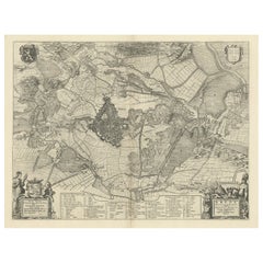
Antique map titled 'Belagerung des Besten Schloss und Passes Gennep'. Old map of the Siege of Gennep, the Netherlands. This map originates from 'Theatrum Europaeum' by M. Merian. Artists and Engravers: Matthäus Merian, engraver, etcher, and book dealer, the leading German illustrator of the 17th century.
Map of Gennep at the time of the siege by the Dutch army under Frederik Hendrik in 1641 during the Eighty Years’ War. Left the town of Gennep, in the center the stronghold Genneperhuis, along the river Maas. In the surrounding landscape the fortifications are indicated, accompanied by brief descriptions. (Belägerung des Vests schloss{...} Passes Gennep; Obsidio Geneappae). 6 June - July 27, 1641. With the circles of citizen's circumlection and their army camps. Bottom left on a pedestal The legend A-C in German.
Artist: Matthäus Merian, engraver, etcher, and book dealer, the leading German illustrator of the 17th century.
Condition: Good, general age-related toning. Some staining with a bigger stain in the lower middle, but outside the image. Please study image carefully.
Date: c.1650
Overall size: 40 x 32 cm.
Image size: 36 x 27 cm.
We sell original antique maps to collectors, historians, educators and interior decorators all over the world. Our collection includes a wide range of authentic antique maps from the 16th to the 20th centuries. Buying and collecting antique maps is a tradition that goes back hundreds of years. Antique maps have proved a richly rewarding investment over the past decade, thanks to a growing appreciation of their unique historical appeal. Today the decorative qualities of antique maps are widely recognized by interior designers who appreciate their beauty and design flexibility. Depending on the individual map, presentation, and context, a rare or antique map can be modern, traditional, abstract, figurative, serious or whimsical. We offer a wide range of authentic antique maps for any budget.
- Dimensions:Height: 12.6 in (32 cm)Width: 15.75 in (40 cm)Depth: 0 in (0.01 mm)
- Materials and Techniques:
- Period:
- Date of Manufacture:circa 1650
- Condition:
- Seller Location:Langweer, NL
- Reference Number:
About the Seller
5.0
Platinum Seller
These expertly vetted sellers are 1stDibs' most experienced sellers and are rated highest by our customers.
Established in 2009
1stDibs seller since 2017
1,916 sales on 1stDibs
Typical response time: <1 hour
- ShippingRetrieving quote...Ships From: Langweer, Netherlands
- Return PolicyA return for this item may be initiated within 14 days of delivery.
More From This SellerView All
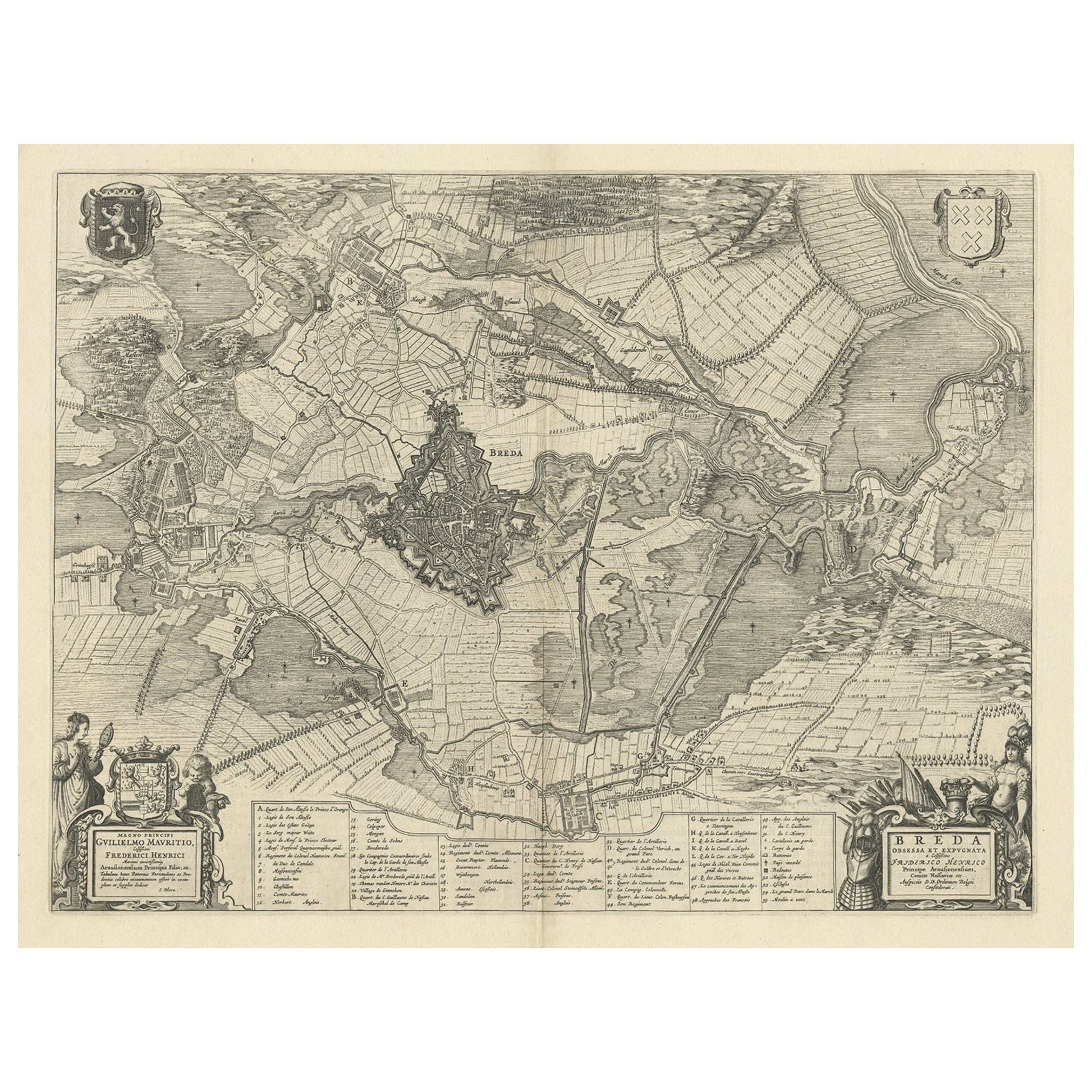
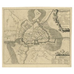
- Antique Map of the Siege of Breda, City in the Netherlands by Blaeu, 1649Located in Langweer, NLAntique map titled 'Breda obsessa et expugnata a Celsissimo Frederico Henrico'. Old map of the city of Breda, the Netherlands. It shows the Siege of Breda in 1637. Originates fro...Category
Antique 17th Century Maps
MaterialsPaper
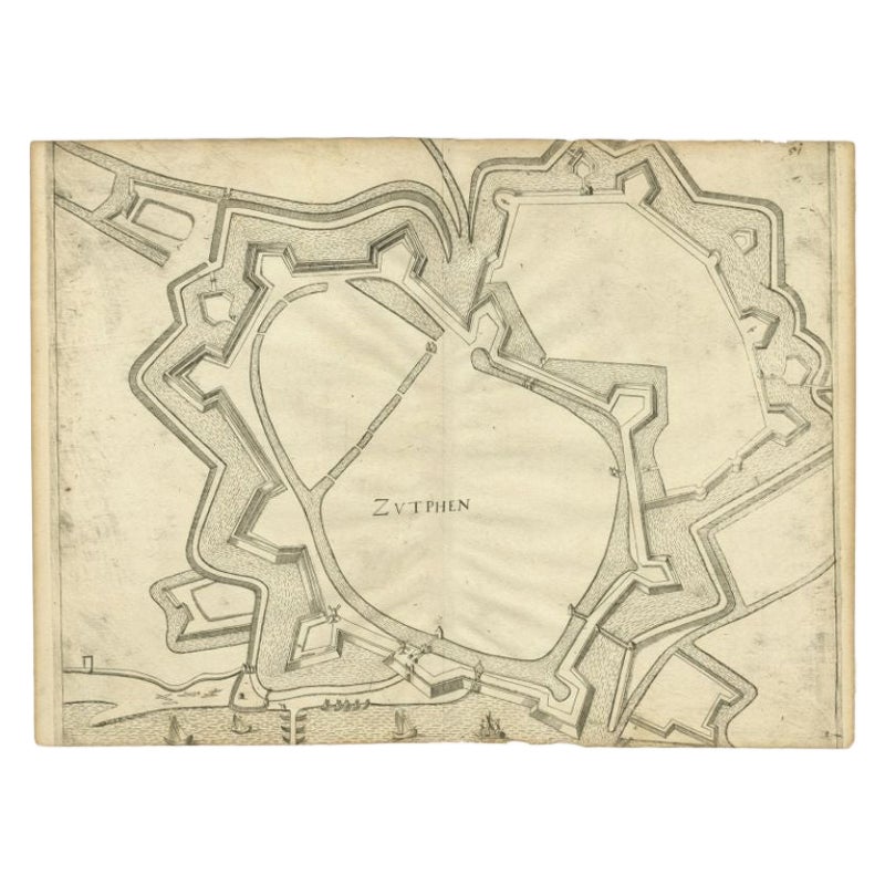
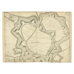
- Antique Map of the City of Zutphen, c.1650Located in Langweer, NLAntique map titled 'Zutphen'. Uncommon original antique map of the city of Zutphen, the Netherlands. Source unknown, to be determined. Artists and Engravers: Anonymous. Conditi...Category
Antique 17th Century Maps
MaterialsPaper
- Antique Map of the Island Java, Indonesia, c.1650Located in Langweer, NLAntique map titled 'Insulae Iavae cum parte insularum Boreno Sumatrae (..)'. Beautiful map of the island of Java and part of Borneo, Bali, Madura and Sumatra. With decorative carto...Category
Antique 17th Century Maps
MaterialsPaper
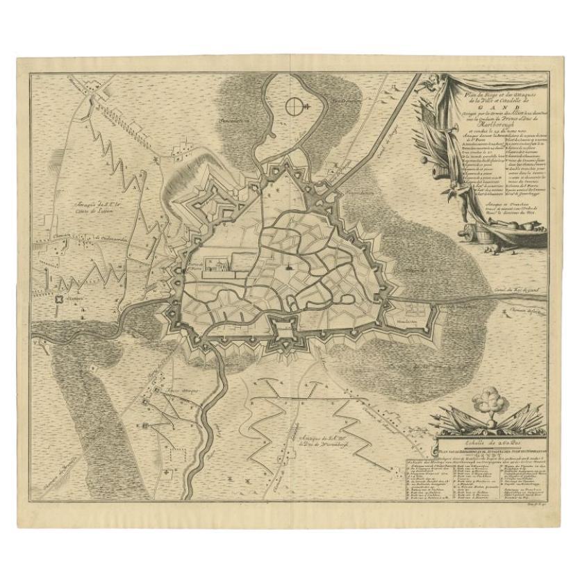
- Antique Map of the Siege of Gent by Dumont, 1729By DumontLocated in Langweer, NLAntique map titled 'Plan of the Siege and Attacks of the City and Citadel of Ghent'. Large map depicting the siege of the Belgian city of Gent in 1708 during the war of the Spanish S...Category
Antique 18th Century Maps
MaterialsPaper
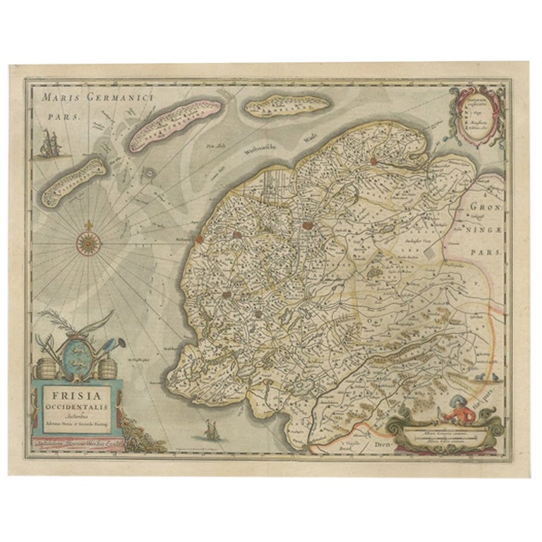
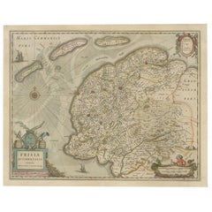
- Antique Map of Friesland, The Netherlands, 1638Located in Langweer, NLAntique map titled 'Frisia Occidentalis'. Original antique map of Friesland, the Netherlands. First state, originating from 'Atlantis novi pars secunda' published 1638. Artis...Category
Antique 17th Century Maps
MaterialsPaper
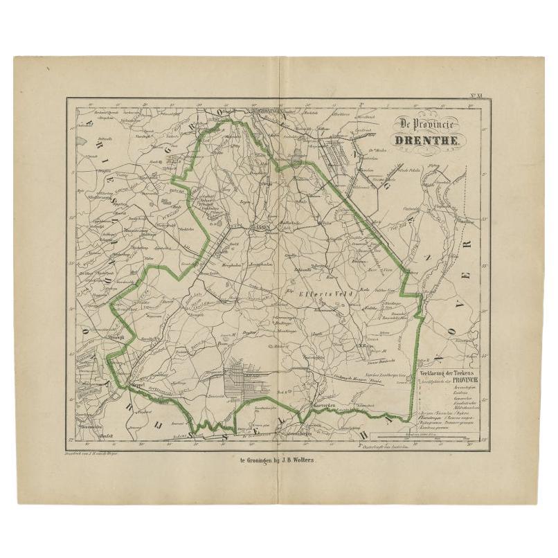
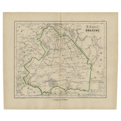
- Antique Map of Drenthe, The Netherlands, 1864Located in Langweer, NLAntique map titled 'De Provincie Drenthe'. Map of the province of Drenthe, the Netherlands. This map originates from 'F. C. Brugsma's Atlas van het Koninkrijk der Nederlanden (..)'. ...Category
Antique 19th Century Maps
MaterialsPaper

You May Also Like
- Original Antique Map of The Netherlands, Engraved by Barlow, Dated 1807Located in St Annes, LancashireGreat map of Netherlands Copper-plate engraving by Barlow Published by Brightly & Kinnersly, Bungay, Suffolk. Dated 1807 Unframed.Category
Antique Early 1800s English Maps
MaterialsPaper
- School Chart or Pull Down Map of Geography of the Netherlands, 1950sLocated in Hemiksem, VANA beautiful old school map of the Netherlands, painted on linen. The map shows the 3 different reliefs (low, middle, high) of the Netherlands. The beau...Category
Vintage 1950s Belgian Mid-Century Modern Maps
MaterialsLinen, Paint
- 1861 Topographical Map of the District of Columbia, by Boschke, Antique MapLocated in Colorado Springs, COPresented is an original map of Albert Boschke's extremely sought-after "Topographical Map of the District of Columbia Surveyed in the Years 1856 ...Category
Antique 1860s American Historical Memorabilia
MaterialsPaper
- 1752 Vaugoundy Map of Flanders : Belgium, France, and the Netherlands, Ric.a002Located in Norton, MALarge Vaugoundy Map of Flanders: Belgium, France, and the Netherlands Colored -1752 Ric.a002 Description: This is a 1752 Didier Robert de Vaugondy map of Flanders. The map de...Category
Antique 17th Century Unknown Maps
MaterialsPaper
- Ordeal of the Hermitage, The Siege of Leningrad 1941-1944, First EditionBy Sergei Varshavsky, Boris RestLocated in valatie, NYThe Ordeal of the Hermitage, The Siege of Leningrad 1941-1944. Leningrad: Aurora Art Publishers, 1985. First edition hardcover with dust jacket. 302 pp. A beautifully photographed bo...Category
20th Century Russian Books
MaterialsPaper
- Original Antique Map of the American State of Nevada, 1889Located in St Annes, LancashireGreat map of Nevada Drawn and Engraved by W. & A.K. Johnston Published By A & C Black, Edinburgh. Original colour Unframed.Category
Antique 1880s Scottish Victorian Maps
MaterialsPaper


Recently Viewed
View AllMore Ways To Browse
Antique The Netherlands
Netherlands War
Antique Old Map Of The World
Netherlands Antique Map
Siege Of
Antique Map Book
Antique Maps Book
Dutch 1650
Book Of Antique Maps
Siege Antique
Antique War Map
Antique Vest
Antique Camp
United States Map Antique
Antique United States Map
Railroad Antique
Antique Maps Of United States
Antique Collectible Bears