Items Similar to Detailed Antique Map of Northern Spanish Region of Aragon, c.1650

Want more images or videos?
Request additional images or videos from the seller
1 of 5
Detailed Antique Map of Northern Spanish Region of Aragon, c.1650
$1,104.91
$1,381.1320% Off
£813.76
£1,017.2020% Off
€920
€1,15020% Off
CA$1,503.14
CA$1,878.9320% Off
A$1,670.32
A$2,087.9020% Off
CHF 875.27
CHF 1,094.0820% Off
MX$20,483.50
MX$25,604.3820% Off
NOK 11,163.50
NOK 13,954.3820% Off
SEK 10,502.21
SEK 13,127.7720% Off
DKK 7,003.82
DKK 8,754.7720% Off
Shipping
Retrieving quote...The 1stDibs Promise:
Authenticity Guarantee,
Money-Back Guarantee,
24-Hour Cancellation
About the Item
Antique map titled 'Arragonia Regnum'.
Detailed map of northern Spanish region of Aragon. The map is centered on the city of Zaragoza, aka, Saragossa. Shows towns, rivers, castles, mountains, etc.
Artists and Engravers: Willem Janszoon Blaeu (1571-1638) was a prominent Dutch geographer and publisher. Born the son of a herring merchant, Blaeu chose not fish but mathematics and astronomy for his focus. He studied with the famous Danish astronomer Tycho Brahe, with whom he honed his instrument and globe making skills. Blaeu set up shop in Amsterdam, where he sold instruments and globes, published maps, and edited the works of intellectuals like Descartes and Hugo Grotius. In 1635, he released his atlas, Theatrum Orbis Terrarum, sive, Atlas novus. Joan Blaeu (23 September 1596 - 28 May 1673) was a Dutch cartographer. He was born in Alkmaar, the son of cartographer Willem Blaeu.
Condition: Good. General age-related toning. Repair on folding line, French text on verso. Please study image carefully.
- Dimensions:Height: 19.3 in (49 cm)Width: 22.84 in (58 cm)Depth: 0 in (0.02 mm)
- Materials and Techniques:
- Period:1650-1659
- Date of Manufacture:circa 1650
- Condition:Repaired: Repair on folding line.
- Seller Location:Langweer, NL
- Reference Number:Seller: BG-06845 1stDibs: LU3054326766072
About the Seller
5.0
Recognized Seller
These prestigious sellers are industry leaders and represent the highest echelon for item quality and design.
Platinum Seller
Premium sellers with a 4.7+ rating and 24-hour response times
Established in 2009
1stDibs seller since 2017
2,494 sales on 1stDibs
Typical response time: 1 hour
- ShippingRetrieving quote...Shipping from: Langweer, Netherlands
- Return Policy
Authenticity Guarantee
In the unlikely event there’s an issue with an item’s authenticity, contact us within 1 year for a full refund. DetailsMoney-Back Guarantee
If your item is not as described, is damaged in transit, or does not arrive, contact us within 7 days for a full refund. Details24-Hour Cancellation
You have a 24-hour grace period in which to reconsider your purchase, with no questions asked.Vetted Professional Sellers
Our world-class sellers must adhere to strict standards for service and quality, maintaining the integrity of our listings.Price-Match Guarantee
If you find that a seller listed the same item for a lower price elsewhere, we’ll match it.Trusted Global Delivery
Our best-in-class carrier network provides specialized shipping options worldwide, including custom delivery.More From This Seller
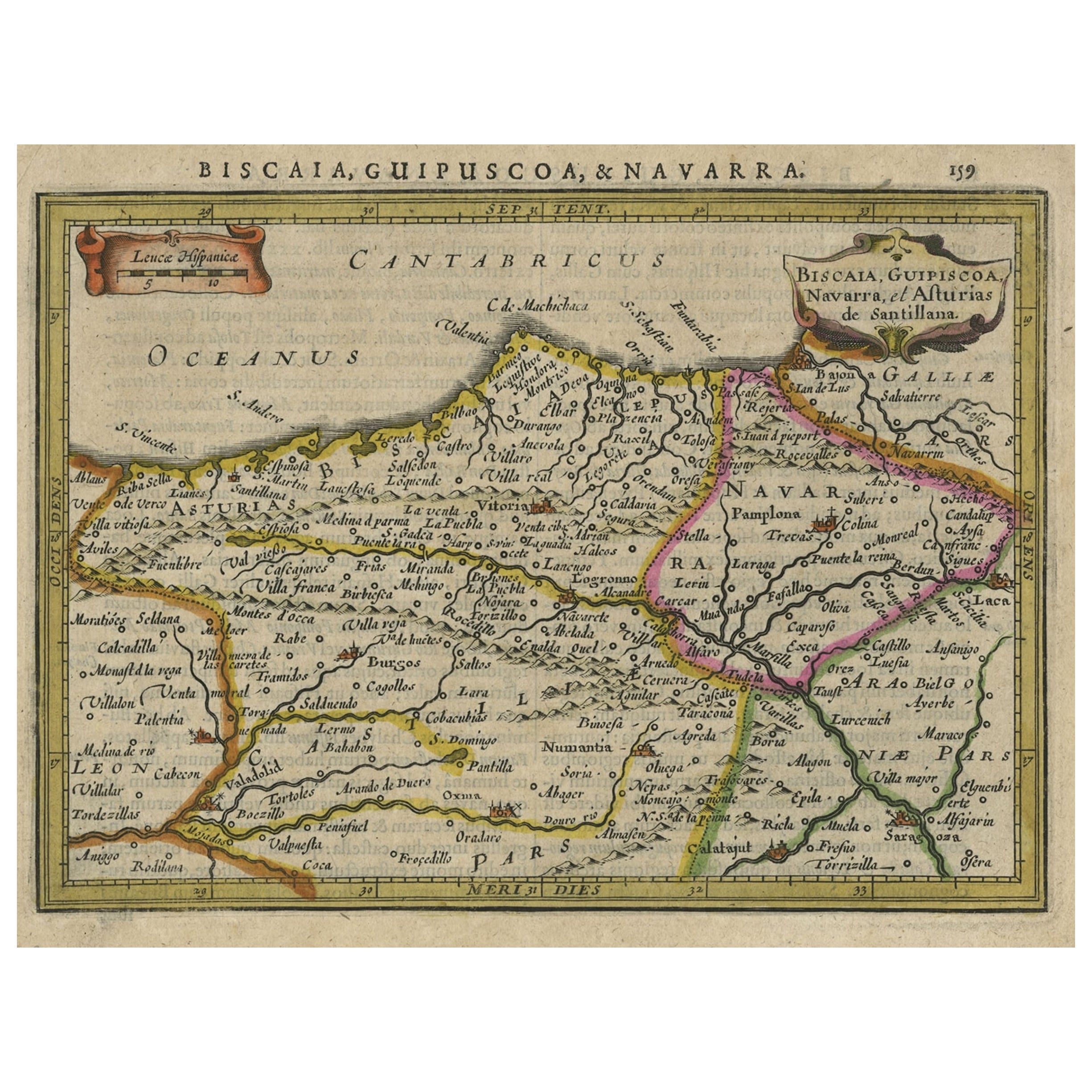
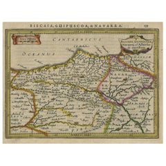
View AllCharming Map of Northeastern Spain with the Areas of Pamplona & Valladolid, 1634
Located in Langweer, NL
Antique map titled 'Biscaia, Guipiscoa, Navarra et Asturias de Santillana'.
Charming map of Northeastern Spain with the areas of Pamplona and Valladolid. This map originates from...
Category
Antique 1630s Maps
Materials
Paper
$422 Sale Price
20% Off
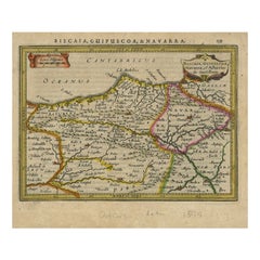
Antique Map of Northeastern Spain by Mercator, 1634
Located in Langweer, NL
Antique map titled 'Biscaia, Guipiscoa, Navarra et Asturias de Santillana'. Charming map of Northeastern Spain with the areas of Pamplona and Valladolid. This map originates from 'At...
Category
Antique 17th Century Maps
Materials
Paper
$133 Sale Price
20% Off
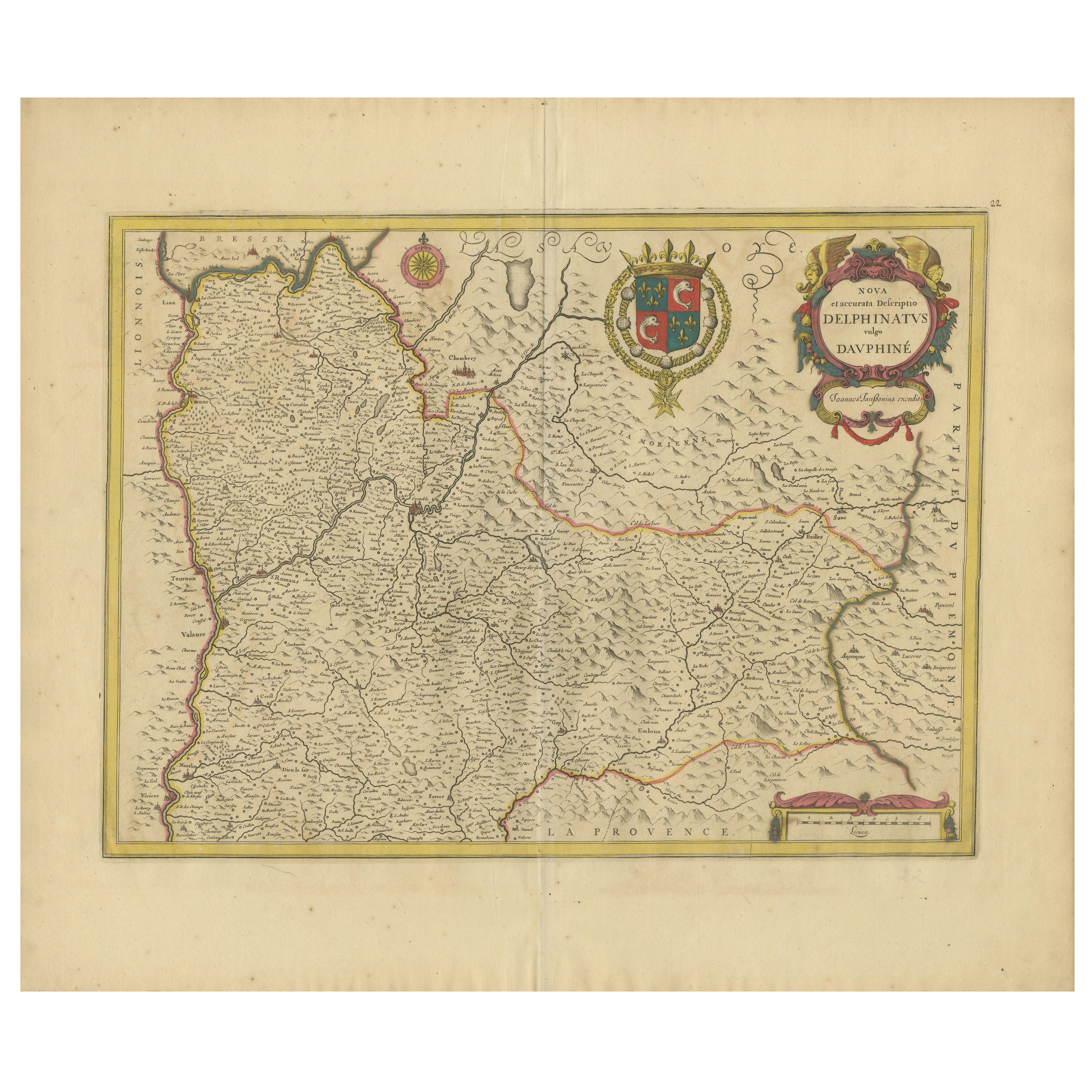
Rare 17th-Century Map of Dauphiné in Southeastern France by F. De Wit, ca.1688
Located in Langweer, NL
Title: Rare Hand-Colored 17th-Century Map of Dauphiné by Frederik De Wit c. 1688
Description: This captivating 17th-century map of Dauphiné, titled "Nova et Accurata Delphinatus Vul...
Category
Antique 1680s Maps
Materials
Paper

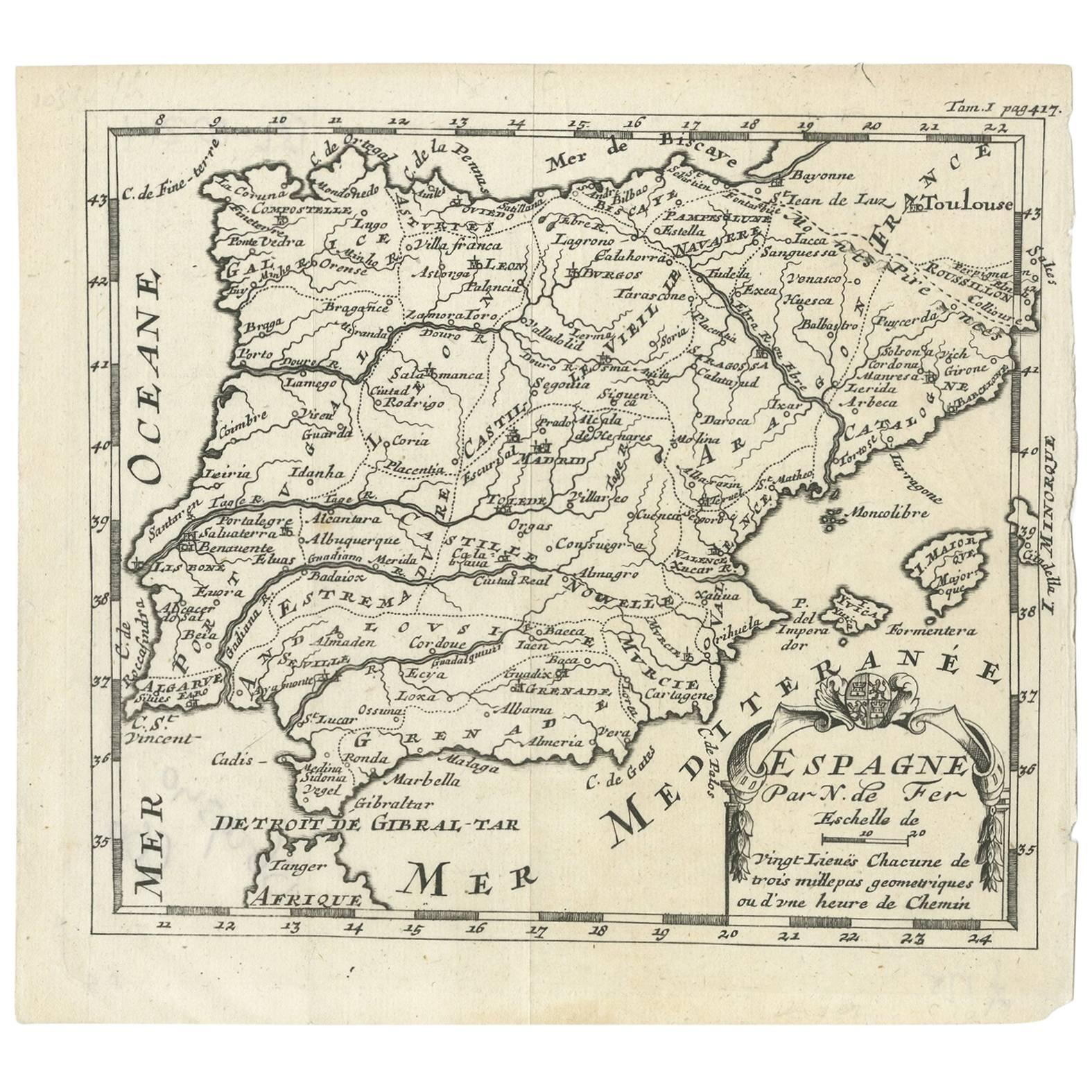
Antique Map of Spain by N. de Fer, circa 1700
Located in Langweer, NL
Antique map of Spain and Portugal with a title cartouche. Nicolas de Fer was the youngest son of the Paris printer and publisher Antoine de Fer. At the ...
Category
Antique Early 18th Century Maps
Materials
Paper
$153 Sale Price
20% Off
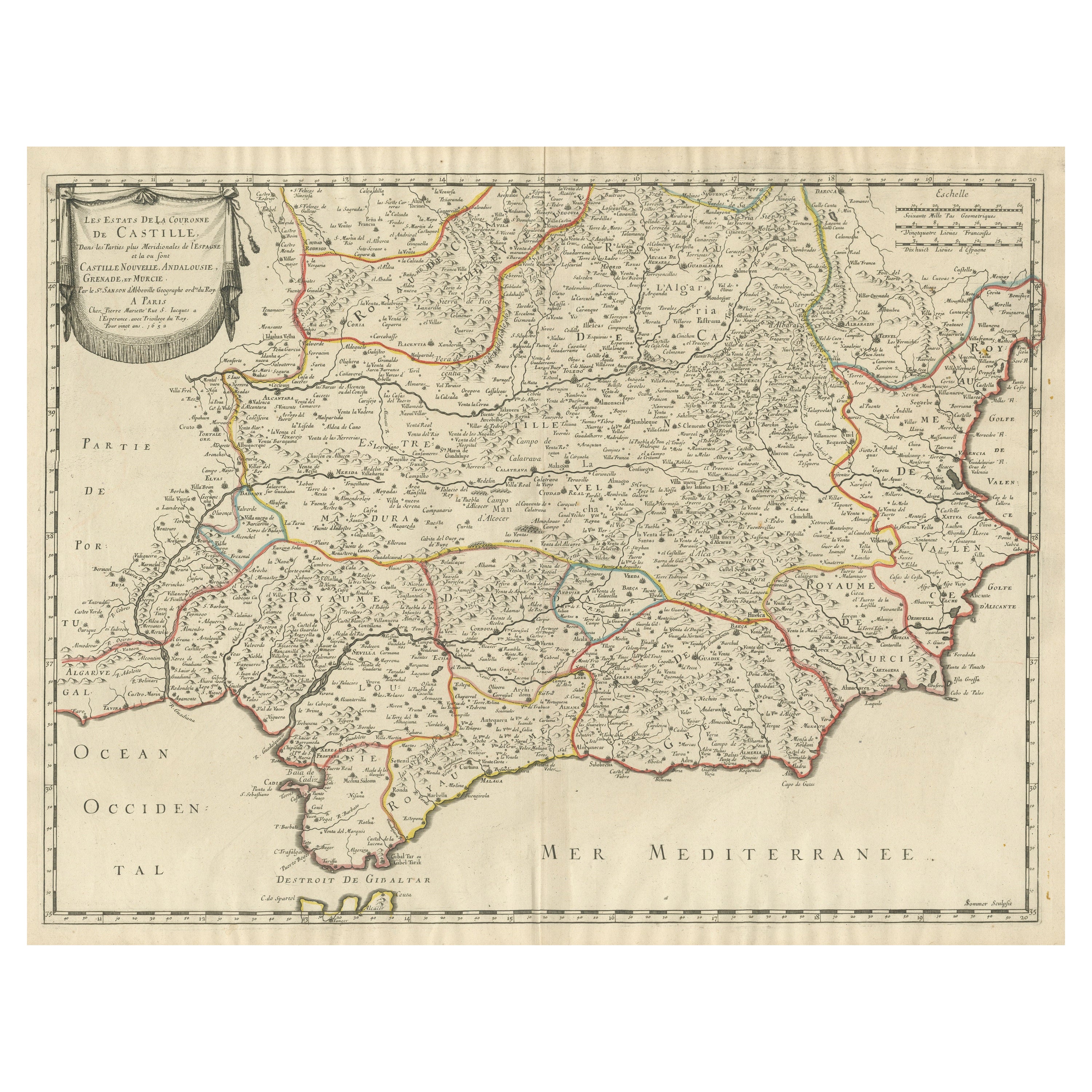
Large Map of Castile's Southern Realms - Granada, Andalusia, and Murcia, 1652
Located in Langweer, NL
This antique map, titled 'Les Etats de la Couronne de Castille', represents the southern regions of the Crown of Castile, specifically the territories of Andalusia, Granada, and Murc...
Category
Antique Mid-17th Century Maps
Materials
Paper

$461 Sale Price
20% Off
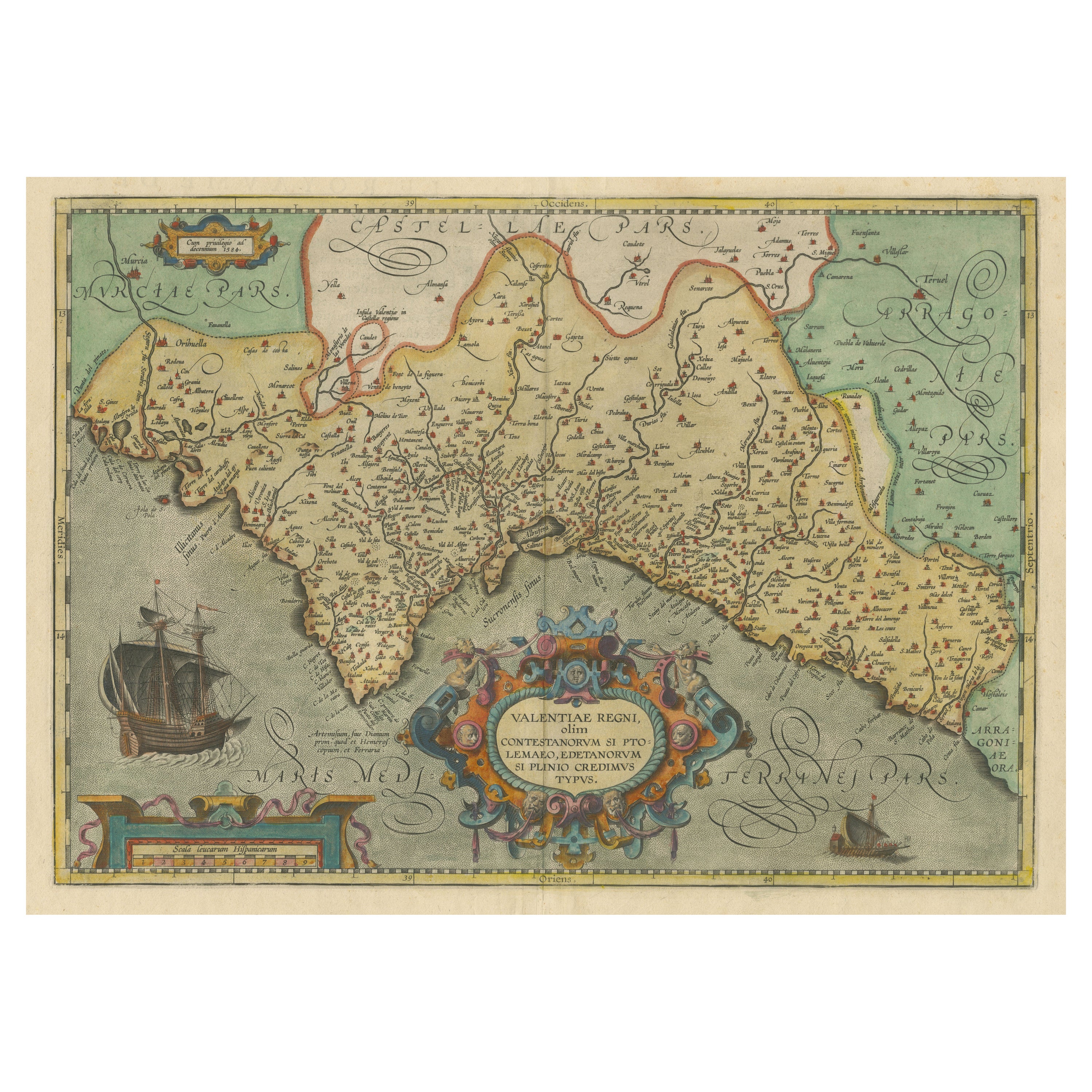
Decorative Original Antique Map of Valencia in Southern Spain, circa 1601
Located in Langweer, NL
This is an original antique map titled 'Valentiae Regni olim Contestanorum Si Ptolemaeo, Edentanorum Si Plinio Credimus Typus'. This is a historical map of the Kingdom of Valencia in...
Category
Antique Early 17th Century Maps
Materials
Paper

$1,345 Sale Price
20% Off
Free Shipping
You May Also Like
1751 Map of Spain Castilla Robert De Vaugondy 1st Edition, Ric.a001
Located in Norton, MA
Large Spain Castilla Robert De Vaugondy
1751 1st Edition
-Colored- Ric.a001
Coming from a family of cartographers, a descendant of the famous Nicolas Sanson and ordinary geographer of the king, Gilles Robert de Vaugondy makes himself known by his maps of the French provinces.
He published an Essay on the History of Geography (1755) from which he excluded the physical geography "too systematic". After a Small Atlas (1748), he draws a universal Atlas (1758), a portable Atlas (1762).
His Atlas of the revolutions of the globe remains unpublished. His warnings and prefaces, his book reviews reveal a Cartesian mind and solid knowledge.
Very early, he associates with his works his son Didier who publishes, since 1742, the methodical tables of Nicolas Sanson, two Globes, one terrestrial, the other celestial (1752).
He is credited with a map of Poland...
Category
Antique 18th Century Unknown Maps
Materials
Paper

18th Century Hand Colored Map of Spain and Portugal by Visscher
By Nicolaes Visscher II
Located in Alamo, CA
This is an early 18th century map of Spain and Portugal, with attractive original hand-coloring, entitled "Hispaniae et Portugalliae Regna per Nicolaum Visscher cum Privilegio Ordinu...
Category
Antique Early 18th Century Dutch Maps
Materials
Paper

1640 Willem Blaeu Map Entitled "Contado di molise et principato vltra, " Ric.a003
By Willem Blaeu
Located in Norton, MA
1640 Willem Blaeu map entitled
"Contado di molise et principato vltra,"
Colored
Ric. a003
Measures: 38 x 49.6 cm and wide margins
DBLAEU.
Cou...
Category
Antique 17th Century Dutch Maps
Materials
Paper

1640 Joan Bleau Map Entitled"Diocecese de rheims et le pais de rethel, " Eic.a011
Located in Norton, MA
1640 Joan Bleau map entitled
"Diocecese de rheims et le pais de rethel,"
Ric.a011
OAN BLAEU
Diocecese de Rheims, et le pais de Rethel.
Handcolored engraving, c.1640.
...
Category
Antique 17th Century Dutch Maps
Materials
Paper

1620 Map of Artois Entitled "Artesia Comitatvs Artois, " by Bleau, Ric.a012
Located in Norton, MA
1640 map of Artois entitled
"Artesia Comitatvs Artois,"
by Bleau
Colored
A-012.
Detailed map of the northern province of Artois, France on the border with Belgium. Feature...
Category
Antique 17th Century Dutch Maps
Materials
Paper

1656 Jansson Map Metz Region of France Entitled "Territorium Metense" Ric0014
Located in Norton, MA
1656 Jansson map Metz Region of France entitled "Territorium Metense."
Ric0014
" Authentic" - Map of the historical region surrounding Metz, in Lorraine, France.
Oriented with ...
Category
Antique 17th Century Dutch Maps
Materials
Paper

More Ways To Browse
Antique Navigational Tools
Antique German Compass
Key Trade Sign
Spanish Galleon
World Map Of Trade Routes
Antique Puerto Rico
Albanian Antique
Antique Furniture Wiltshire
Antique Maps Of Israel
Framed Africa Maps
Antique Furniture Goa
Croatian Antiques
Map Of Israel
Teak Sphere
18th Century Scottish Collectibles
Map Of Mexican California
Ottoman Map
Antique Map Of Korea