Items Similar to Detailed Map of the Madura Strait, between Java & Madura Island, Indonesia, 1825


Want more images or videos?
Request additional images or videos from the seller
1 of 6
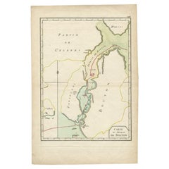
Detailed Map of the Madura Strait, between Java & Madura Island, Indonesia, 1825
$1,123.86
$1,497.6824% Off
£836.48
£1,114.7224% Off
€938
€1,25024% Off
CA$1,539.41
CA$2,051.4524% Off
A$1,712.15
A$2,281.6624% Off
CHF 894.03
CHF 1,191.4124% Off
MX$20,835.10
MX$27,765.3324% Off
NOK 11,418.18
NOK 15,216.1224% Off
SEK 10,708.24
SEK 14,270.0424% Off
DKK 7,140.67
DKK 9,515.8124% Off
Shipping
Retrieving quote...The 1stDibs Promise:
Authenticity Guarantee,
Money-Back Guarantee,
24-Hour Cancellation
About the Item
Antique map titled 'Plan du Détroit de Madura'.
Detailed map of the Madura Strait in Indonesia. The eastern part of the island Java with the city of Gresik and the western part of Pulau Madura with the city Bangkalam. In the lower part of the map a view of the strait of Madura between Java and the Fort d'Orange. This map originates from 'Journal de la navigation autour du globe de la frégate "la Thétis" et de la corvette "l'Espérance"'.
Artists and Engravers: Ambroise Tardieu ( 1788 - 1841 in Paris) was an eminent French cartographer and engraver, and is celebrated for his version of John Arrowsmith's 1806 map of the United States. Tardieu's son, Auguste Ambroise Tardieu (1818-1879), was also an artist and a famous forensic medical scholar, who supplied the illustrations for Dr. Pierre François Olive Rayer's three-volume Traité des maladies des reins (1839-41), a treatise on diseases of the kidneys.
- Dimensions:Height: 26.78 in (68 cm)Width: 19.89 in (50.5 cm)Depth: 0 in (0.02 mm)
- Materials and Techniques:
- Period:
- Date of Manufacture:1825
- Condition:Wear consistent with age and use. Condition: Fair, general age-related toning. Few marginal tears and some creasing. Please study image carefully.
- Seller Location:Langweer, NL
- Reference Number:Seller: BG-00761 1stDibs: LU3054327034252
About the Seller
5.0
Recognized Seller
These prestigious sellers are industry leaders and represent the highest echelon for item quality and design.
Platinum Seller
Premium sellers with a 4.7+ rating and 24-hour response times
Established in 2009
1stDibs seller since 2017
2,502 sales on 1stDibs
Typical response time: <1 hour
- ShippingRetrieving quote...Shipping from: Langweer, Netherlands
- Return Policy
Authenticity Guarantee
In the unlikely event there’s an issue with an item’s authenticity, contact us within 1 year for a full refund. DetailsMoney-Back Guarantee
If your item is not as described, is damaged in transit, or does not arrive, contact us within 7 days for a full refund. Details24-Hour Cancellation
You have a 24-hour grace period in which to reconsider your purchase, with no questions asked.Vetted Professional Sellers
Our world-class sellers must adhere to strict standards for service and quality, maintaining the integrity of our listings.Price-Match Guarantee
If you find that a seller listed the same item for a lower price elsewhere, we’ll match it.Trusted Global Delivery
Our best-in-class carrier network provides specialized shipping options worldwide, including custom delivery.More From This Seller
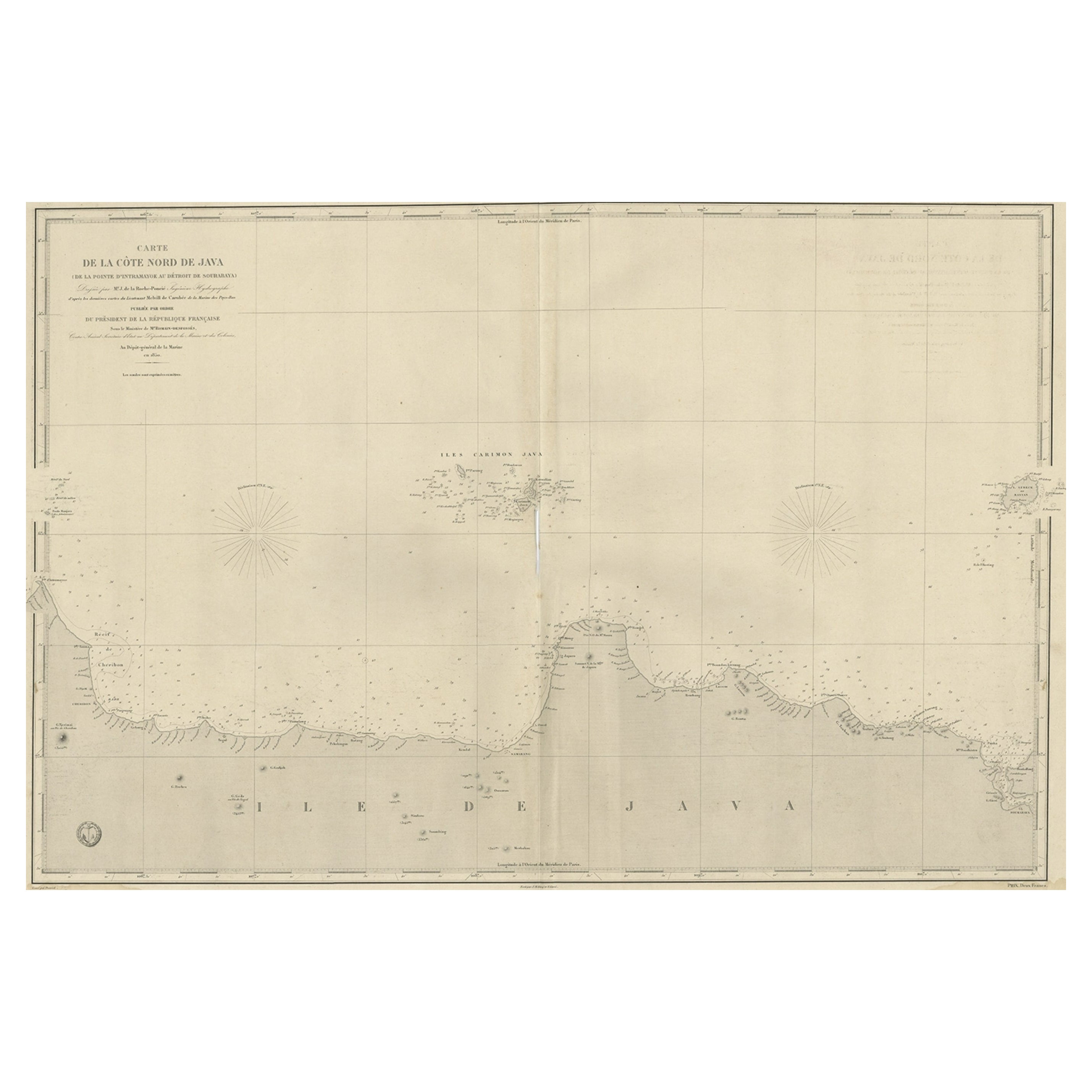
View AllEarly French Nautical Chart of the Northern Coast of of Java, Indonesia, C.1850
Located in Langweer, NL
Antique map titled Carte de la côte Nord de Java.
Early French nautical chart of the northern coast of the island of Java, Indonesia. It includes Ci...
Category
Antique 1850s Maps
Materials
Paper
$1,102 Sale Price
20% Off
Antique Map of Indonesia by C.F. Beautemps-Beaupre, circa 1807
Located in Langweer, NL
Antique map titled 'Carte de la partie du grand archipel d'Asie'. Map of Indonesia showing tracks of Recherche and Esperance in 1792-1793. This map is...
Category
Antique Early 19th Century Maps
Materials
Paper

$718 Sale Price
20% Off
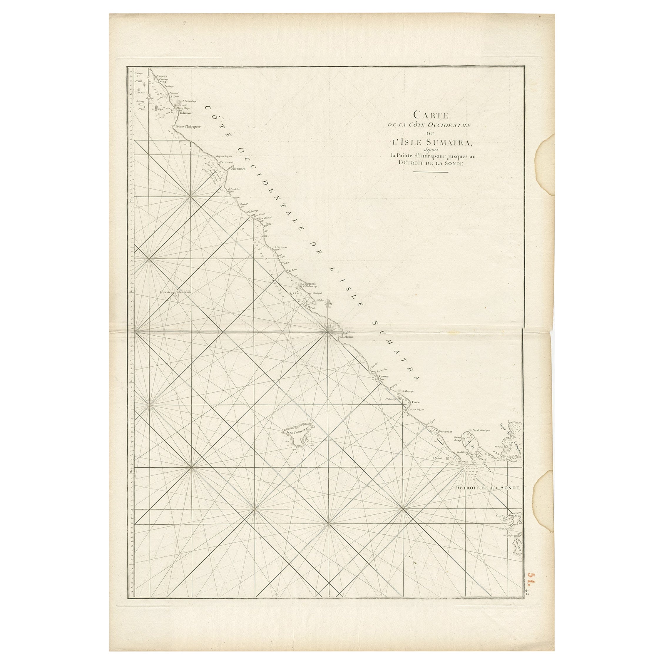
Sea Chart of Part of the Southwestern Coast of Sumatra & Nias, Indonesia, C1775
Located in Langweer, NL
Antique map titled 'Carte de la Côte Occidentale de l'Isle Sumatra'. Sea chart of the part of the south-western coast of Sumatra with the Nassau (Nias) and Fortune isles.
Artists ...
Category
Antique 1770s Maps
Materials
Paper

$485 Sale Price
25% Off
Antique Sea Chart of the Coast of Sumatra, Indonesia, circa 1775
Located in Langweer, NL
Antique map titled 'Carte de la Côte Occidentale de l'Isle Sumatra'. Sea chart of the part of the south-western coast of Sumatra with the Nassau (Nias) and Fortune isles.
Artists ...
Category
Antique 18th Century Maps
Materials
Paper
$517 Sale Price
20% Off
Old Map of Cook's Discovery and Charting of the East Coast of Australia, 1803
Located in Langweer, NL
Antique map titled 'Kaart van Nieuw Zuid Wales of de Oostlyke Kust van Nieuw Holland ontdekt en onderzogt door den Luitenant J. Cook met het Schip de Endeavour in het Jaar 1770'.
...
Category
Antique Early 1800s Maps
Materials
Paper

$1,677 Sale Price
20% Off
Antique Map of the Buton Strait by Philippe, 1787
Located in Langweer, NL
Antique map titled 'Carte du Détroit de Bouton'. Map of the Buton Strait between Paula Buton and Celebes, Indonesia. This map originates from 'World atlas for the study of geography ...
Category
Antique 18th Century Maps
Materials
Paper
$115 Sale Price
20% Off
You May Also Like
Large U.S. Coast and Geodetic Survey Chart A of the Atlantic Coast, 1877
Located in Nantucket, MA
Large U.S. Coast and Geodetic Survey Chart A of the Atlantic Coast, 1877, re-issued in February 1881, a printed paper laid down on linen navigational chart of the U.S. Atlantic coast...
Category
Antique 1880s American Other Maps
Materials
Linen

Scarce U.S. Coast Survey Map Depicting Entrance to San Francisco Bay Dated 1856
Located in San Francisco, CA
A fine example of the 1856 U.S. Coast lithographic survey nautical chart of the entrance to San Francisco bay and the city. Published in 1856 by the Office of the Coast Survey the of...
Category
Antique Mid-19th Century American Maps
Materials
Paper

Antique Maritime Chart of East Coast Virginia to Nova Scotia
Located in Norwell, MA
1920 nautical chart of the East Coast of the United States from Virginia to Maine, New Brunswick, and Nova Scotia. The chart shows Cape Cod, Long Island, the Connecticut coast, Jersey Shore, Maine, New Hampshire, etc. Very detailed, showing ports, lighthouses, shoals, depths, etc. The chart is by famous cartographer George W. Eldridge, compiled from surveys of the United States government, British Admiralty, George Eldridge, and others. First authorized by George Eldridge, published in 1916 by Wilfred O. White with a merchant's stamp of Charles Hutchinson...
Category
Vintage 1920s North American Maps
Materials
Paper

West Coast of Africa, Guinea & Sierra Leone: An 18th Century Map by Bellin
By Jacques-Nicolas Bellin
Located in Alamo, CA
Jacques Bellin's copper-plate map entitled "Partie de la Coste de Guinee Dupuis la Riviere de Sierra Leona Jusquau Cap das Palmas", depicting the coast of Guinea and Sierra Leone in ...
Category
Antique Mid-18th Century French Maps
Materials
Paper

Long Island Chart from 1828
Located in Norwell, MA
Rare original chart of Long Island Sound by E + G Blunt of New York, 179 Water St. "Surveyed in the years 1828, 29 & 30" Exceedingly rare and early chart, titled Long Island Sound fr...
Category
Antique 1830s Nautical Objects
Materials
Paper

Original Antique Map of South East Asia by Thomas Clerk, 1817
Located in St Annes, Lancashire
Great map of South East Asia
Copper-plate engraving
Drawn and engraved by Thomas Clerk, Edinburgh.
Published by Mackenzie And Dent, 1817
Unframed.
Category
Antique 1810s English Maps
Materials
Paper

More Ways To Browse
Medical Collectibles
Antique Furniture Detroit
Medical Curiosities
Antique Medical Collectibles
L Tardieu
Ottoman Map
Antique Map Of Korea
Maps South East Asia
Antique Furniture Kansas City
Antique Great Lakes Map
Arnold And Son
Indianapolis Antique Furniture
Antique Map Of Jerusalem
Antique Maps Of Sicily
Antique Celestial Maps
Antique Compass Maritime Compasses
Bengal Map
J C Walker Map