Items Similar to Large Copper Engraved Map of the Coastline of Friesland and Terschelling, c.1670


Want more images or videos?
Request additional images or videos from the seller
1 of 5
Large Copper Engraved Map of the Coastline of Friesland and Terschelling, c.1670
$853.08
$1,066.3520% Off
£635.06
£793.8320% Off
€712
€89020% Off
CA$1,168.50
CA$1,460.6320% Off
A$1,299.63
A$1,624.5420% Off
CHF 678.63
CHF 848.2820% Off
MX$15,815.13
MX$19,768.9220% Off
NOK 8,667.10
NOK 10,833.8820% Off
SEK 8,128.21
SEK 10,160.2720% Off
DKK 5,420.21
DKK 6,775.2620% Off
Shipping
Retrieving quote...The 1stDibs Promise:
Authenticity Guarantee,
Money-Back Guarantee,
24-Hour Cancellation
About the Item
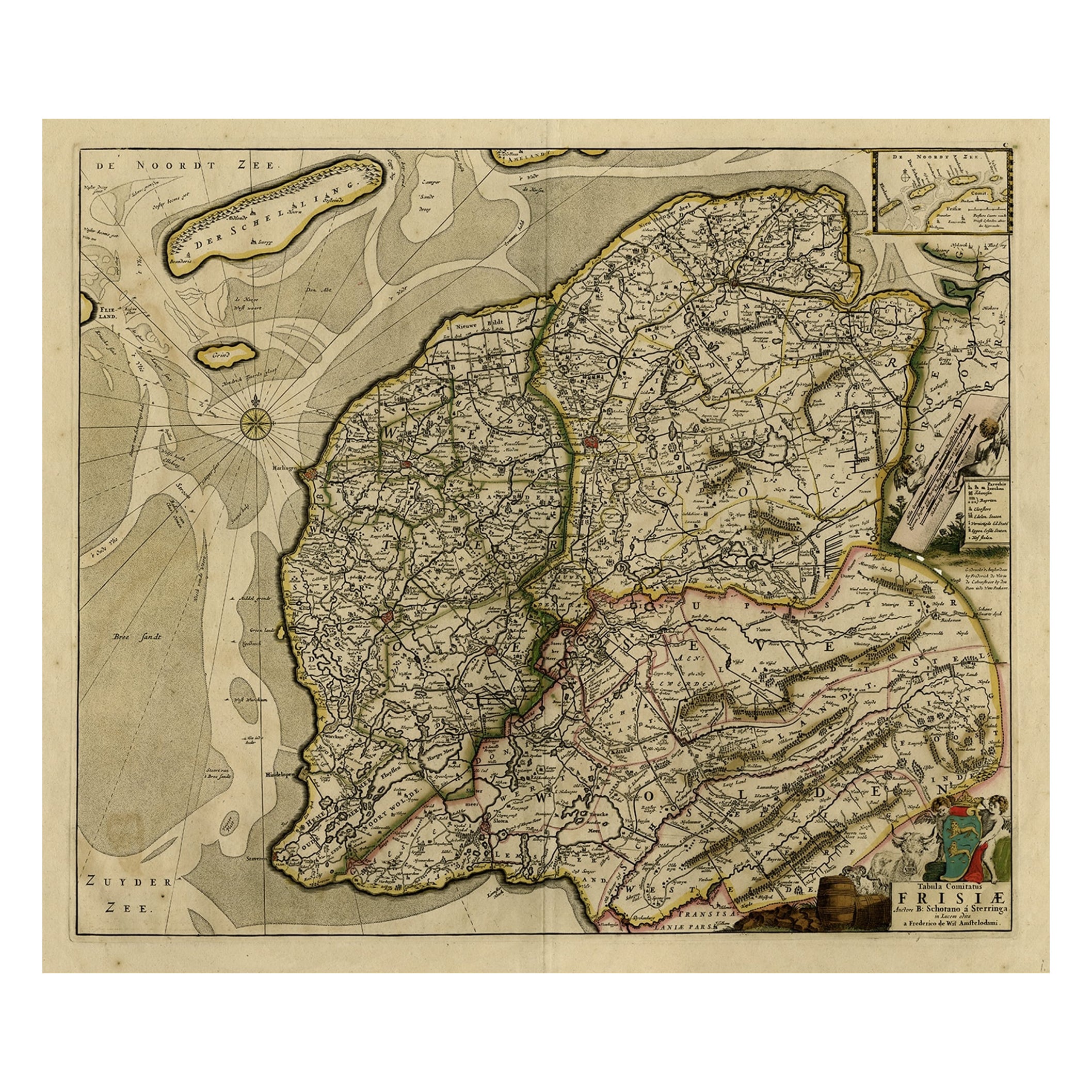
Antique print, titled: 'Dominii Frisiae Tabula, inter Flevum et Lavicum (…)'
This large copper engraved map details the coastline of Friesland and Terschelling. At east is a part of Groningen. The main cities are colored in red. The very decorative cartouches displays putti and a coat of arms. At the right corner there is an inset with the isles belonging to this province. From: 'Germania Inferiorsive XVII Provinciarum Geographicae Generalis uit et Particulares tabulae.' (Kaert-Boeck van de XVII Nederlandtsche Provincien.), published by Nicolaas Visscher II in Amsterdam. ca. 1670. Exact ed. to be determined. Ref: Koeman III Vis 10 (18).
Artists and Engravers: Publisher: Nicolaes Visscher II. Cartographer: Bernardus Schotanus a Sterringa (1640-1704). Publisher: The Visscher family were art and map dealers in Amsterdam during the 17th century. Funded by C. J. Visscher (1587-1652), the business was continued by his son and grandson both named Nicolas. Nicolas Visscher I was born 1618 in Wenns, Austria. He died 1679 in Linz. After the death of Nicolas II, his widow passed the business to Pieter Schenk.
- Dimensions:Height: 20.28 in (51.5 cm)Width: 23.9 in (60.7 cm)Depth: 0 in (0.02 mm)
- Materials and Techniques:
- Period:1670-1679
- Date of Manufacture:circa 1670
- Condition:Condition: Good, given age. Original middle fold, as issued. Slight paper separation at top and lower middle fold, Backed. Remains of paper from previous Atlas attachment at rear middle fold. Paper edges browned. Light soiling. Original coloring.
- Seller Location:Langweer, NL
- Reference Number:Seller: PCT-563881stDibs: LU3054327589542
About the Seller
5.0
Recognized Seller
These prestigious sellers are industry leaders and represent the highest echelon for item quality and design.
Platinum Seller
Premium sellers with a 4.7+ rating and 24-hour response times
Established in 2009
1stDibs seller since 2017
2,508 sales on 1stDibs
Typical response time: <1 hour
- ShippingRetrieving quote...Shipping from: Langweer, Netherlands
- Return Policy
Authenticity Guarantee
In the unlikely event there’s an issue with an item’s authenticity, contact us within 1 year for a full refund. DetailsMoney-Back Guarantee
If your item is not as described, is damaged in transit, or does not arrive, contact us within 7 days for a full refund. Details24-Hour Cancellation
You have a 24-hour grace period in which to reconsider your purchase, with no questions asked.Vetted Professional Sellers
Our world-class sellers must adhere to strict standards for service and quality, maintaining the integrity of our listings.Price-Match Guarantee
If you find that a seller listed the same item for a lower price elsewhere, we’ll match it.Trusted Global Delivery
Our best-in-class carrier network provides specialized shipping options worldwide, including custom delivery.More From This Seller
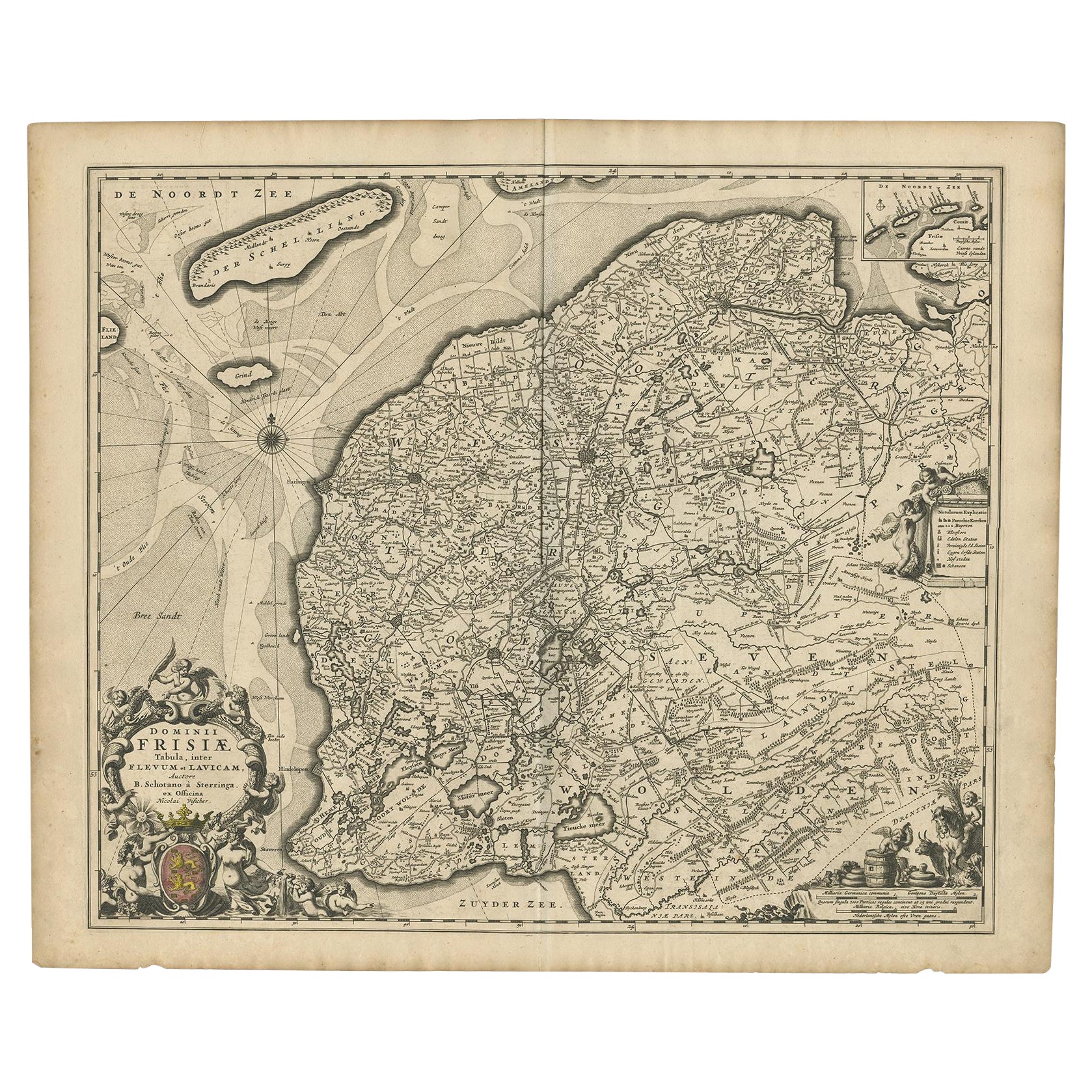
View AllAntique Map: Friesland and Terschelling with Inset Isles, by Visscher II, 1670
By Nicolaes Visscher II
Located in Langweer, NL
Antique Map: Friesland and Terschelling with Inset Isles, by Nicolaas Visscher II, 1670
This large copper-engraved map provides a detailed and visually stunning depiction of the coastline of Friesland and the island of Terschelling, along with portions of Groningen to the east. Originating from Nicolaas Visscher II’s *Germania Inferiorsive XVII Provinciarum Geographicae Generalis* (Kaert-Boeck van de XVII Nederlandtsche Provincien), this map was published in Amsterdam circa 1670.
The map highlights the main cities of Friesland, beautifully accented in red, and includes a decorative inset in the lower-right corner, illustrating the smaller isles belonging to the province. The finely engraved details make this map a remarkable artifact of 17th-century cartography, with its coastline features rendered with precision and artistic flair.
Adding to its charm, the map is adorned with elaborate decorative cartouches featuring putti (cherubs) and a coat of arms, hallmark elements of Nicolaas Visscher II’s cartographic artistry. Visscher was one of the most prominent Dutch mapmakers of the Golden Age of Cartography, known for his dedication to both geographical accuracy and artistic embellishment. His maps were highly sought after during his lifetime and remain prized by collectors today.
Keywords: antique map Friesland, Terschelling map, Nicolaas Visscher II, 17th-century Dutch cartography, Groningen coastline map, decorative map cartouches, Germania Inferiorsive XVII Provinciarum, Kaert-Boeck Nederlandtsche Provincien, historical Dutch maps, rare collectible maps, Golden Age cartography.
This map is a treasure for collectors of antique cartography...
Category
Antique Late 17th Century Maps
Materials
Paper

$934 Sale Price
20% Off
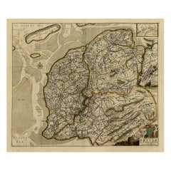
Map of Friesland with Terschelling, Vlieland, Ameland En Schiermonnikoog, C.1670
Located in Langweer, NL
Antique print, titled: 'Tabula Comitatus Frisiae …'
Map of Friesland with the island Terschelling, Vlieland, Ameland en Schiermonnikoog. With a cartouche and a compass rose. Publ...
Category
Antique 1670s Maps
Materials
Paper
$524 Sale Price
40% Off
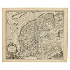
Antique Map of Friesland by De Wit, c.1690
Located in Langweer, NL
Antique map titled 'Tabula Comitatus Frisiae'.
Old map of the province of Friesland, the Netherlands. With a small inset map of the Wadden area. Third state of the map by Schotan...
Category
Antique 17th Century Maps
Materials
Paper

$785 Sale Price
20% Off
Beautiful First State Map of Friesland, the Netherlands, c.1665
Located in Langweer, NL
Antique map titled 'Dominii Frisiae Tabula, inter Flevum et Lavicam'. Beautiful first state map of Friesland, the Netherlands. With small inset map of the Frisian Wadden islands Vlie...
Category
Antique 17th Century Maps
Materials
Paper
$838 Sale Price
20% Off
Antique Map of Friesland, A Dutch Province, c.1780
Located in Langweer, NL
Antique map titled 'Dominii Frisiae (..)'. Original antique map of Friesland. 3rd state, most likely published after 1775 (De Rijke, 46.3). Artists and Engravers: Published by P. Sch...
Category
Antique 18th Century Maps
Materials
Paper

$910 Sale Price
20% Off
Antique Map of the Province of Friesland in The Netherlands, 1718
Located in Langweer, NL
Antique map titled 'Frisiae Dominium vernacule Friesland (..)'.
Original antique map of Friesland, the Netherlands. Originates from 'Uitbeelding van de Heerlijkheid van Friesland...
Category
Antique 18th Century Maps
Materials
Paper

$718 Sale Price
20% Off
You May Also Like
1643 Willem&Joan Blaeu Map NW Flanders "Flandriae Teutonicae Pars Prientalior
Located in Norton, MA
1643 Willem and Joan Blaeu map of northwest Flanders, entitled
"Flandriae Teutonicae Pars Prientalior,"
Ric0012
" Authentic" - Map of the northwest Fl...
Category
Antique 17th Century Dutch Maps
Materials
Paper

1752 Vaugoundy Map of Flanders : Belgium, France, and the Netherlands, Ric.a002
Located in Norton, MA
Large Vaugoundy Map of Flanders:
Belgium, France, and the Netherlands
Colored -1752
Ric.a002
Description: This is a 1752 Didier Robert de Vaugondy map of Flanders. The map de...
Category
Antique 17th Century Unknown Maps
Materials
Paper

1635 Willem Blaeu Map of Northern France"Comitatvs Bellovacvm" Ric.a08
Located in Norton, MA
1635 Willem Blaeu map of northern France, entitled.
"Comitatvs Bellovacvm Vernacule Beavvais,"
Colored
Ric.a008
“COMITATVS BELLOVACVM…” Amsterdam: W...
Category
Antique 17th Century Unknown Maps
Materials
Paper

Map of the Netherlands - Etching by G. Braun and F. Hogenberg -Late 16th Century
By Franz Hogenberg
Located in Roma, IT
Map of the Netherlands is an original etching realized by George Braun and Franz Hogenberg, as part of the "Civitates Orbis Terrarum".
The “Civitates Orbis Terrarum” (Atlas of Citi...
Category
16th Century Figurative Prints
Materials
Etching

17th Century Hand Colored Map of the Liege Region in Belgium by Visscher
By Nicolaes Visscher II
Located in Alamo, CA
An original 17th century map entitled "Leodiensis Episcopatus in omnes Subjacentes Provincias distincté divisusVisscher, Leodiensis Episcopatus" by Nicolaes Visscher II, published in Amsterdam in 1688. The map is centered on Liege, Belgium, includes the area between Antwerp, Turnhout, Roermond, Cologne, Trier and Dinant.
This attractive map is presented in a cream-colored mat measuring 30" wide x 27.5" high. There is a central fold, as issued. There is minimal spotting in the upper margin and a tiny spot in the right lower margin, which are under the mat. The map is otherwise in excellent condition.
The Visscher family were one of the great cartographic families of the 17th century. Begun by Claes Jansz Visscher...
Category
Antique Late 17th Century Dutch Maps
Materials
Paper

Utrecht, Netherlands: A Large 17th Century Hand-colored Map by Sanson & Jaillot
By Nicholas Sanson d'Abbeville
Located in Alamo, CA
This large hand-colored map entitled "La Seigneurie d'Utrecht. Dressé sur les memoires les plus nouveaux par le Sr. Sanson" was originally created by Nicholas Sanson d'Abbeville. Thi...
Category
1690s Landscape Prints
Materials
Engraving

More Ways To Browse
Dior Coat Red
John Speed Maps
Antique Map Of Turkish Empire
Antique Portuguese Scales
Canadian Atlas Furniture
Prussia Map
Afghanistan Map
Malabar Map
Antique Compass Made In France
Antique Maps Dublin
Antique Newfoundland Canada
John Speed Antique Maps
Malaysia Map
Sebastian Munster
Antique Map Chile
Antique Map Of Boston
Ipswich Antique Furniture
Maps Balkans