Items Similar to Beautiful First State Map of Friesland, the Netherlands, c.1665


Want more images or videos?
Request additional images or videos from the seller
1 of 5
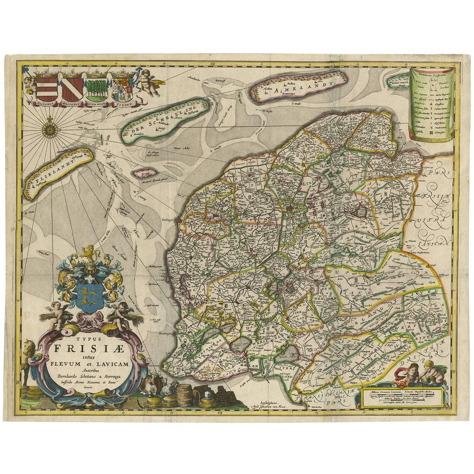
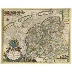
Beautiful First State Map of Friesland, the Netherlands, c.1665
About the Item
Antique map titled 'Dominii Frisiae Tabula, inter Flevum et Lavicam'. Beautiful first state map of Friesland, the Netherlands. With small inset map of the Frisian Wadden islands Vlieland, Terschelling, Ameland and Schiermonnikoog. Artists and Engravers: Cartographer: Bernardus Schotanus a Sterringa (1640-1704).
Artist: Cartographer: Bernardus Schotanus a Sterringa (1640-1704).
Condition: Very good, general age-related toning. Please study image carefully.
Date: c.1665
Overall size: 63 x 53 cm.
Image size: 56 x 47 cm.
We sell original antique maps to collectors, historians, educators and interior decorators all over the world. Our collection includes a wide range of authentic antique maps from the 16th to the 20th centuries. Buying and collecting antique maps is a tradition that goes back hundreds of years. Antique maps have proved a richly rewarding investment over the past decade, thanks to a growing appreciation of their unique historical appeal. Today the decorative qualities of antique maps are widely recognized by interior designers who appreciate their beauty and design flexibility. Depending on the individual map, presentation, and context, a rare or antique map can be modern, traditional, abstract, figurative, serious or whimsical. We offer a wide range of authentic antique maps for any budget.
- Dimensions:Height: 20.87 in (53 cm)Width: 24.81 in (63 cm)Depth: 0 in (0.01 mm)
- Materials and Techniques:
- Period:
- Date of Manufacture:c.1665
- Condition:
- Seller Location:Langweer, NL
- Reference Number:
About the Seller
5.0
Platinum Seller
These expertly vetted sellers are 1stDibs' most experienced sellers and are rated highest by our customers.
Established in 2009
1stDibs seller since 2017
1,929 sales on 1stDibs
Typical response time: <1 hour
- ShippingRetrieving quote...Ships From: Langweer, Netherlands
- Return PolicyA return for this item may be initiated within 14 days of delivery.
More From This SellerView All
- Antique Map of Leeuwarderadeel in Friesland, The Netherlands, 1868Located in Langweer, NLAntique map titled 'Provincie Friesland - Gemeente Leeuwarderadeel'. Map of the township of Leeuwarderadeel including Friesland's Capital Leeuwarden and furthermore: Wirdum, Wytg...Category
Antique 19th Century Maps
MaterialsPaper
- Antique Map of Gaasterland, Friesland in the Netherlands, 1868Located in Langweer, NLAntique map titled 'Provincie Friesland - Gemeente Gaasterland'. Map of the township of Gaasterland including Balk, Bakhuizen, Wijckel, Sloten and many other villages. This map origi...Category
Antique 19th Century Maps
MaterialsPaper
- Antique Map of Gaasterland in Friesland, the Netherlands, 1718Located in Langweer, NLAntique map titled 'Gaasterland. De zevende Grietenije van de Zevenwolden (..)'. Original antique map of Gaasterland, Friesland, the Netherlands. Originates from 'Uitbeelding van de ...Category
Antique 18th Century Maps
MaterialsPaper
- Antique Map of Friesland 'The Netherlands' by J. Bussemacher, 1596By Johann BussemacherLocated in Langweer, NLBeautiful hand-colored engraving of the province Friesland (The Netherlands). This map originates from the Atlas 'Europae totius orbis terrarium partis praestantissimae, universalis ...Category
Antique 16th Century Maps
MaterialsPaper
- Antique Map of Friesland 'The Netherlands' by B. Schotanus, 1664By B. SchotanusLocated in Langweer, NLHand-colored map of the Dutch province Friesland. Also shows the Wadden islands Vlieland, Terschelling and Ameland and a part of Schiermonnikoog. With a decorative cartouche with two...Category
Antique Late 17th Century Maps
MaterialsPaper
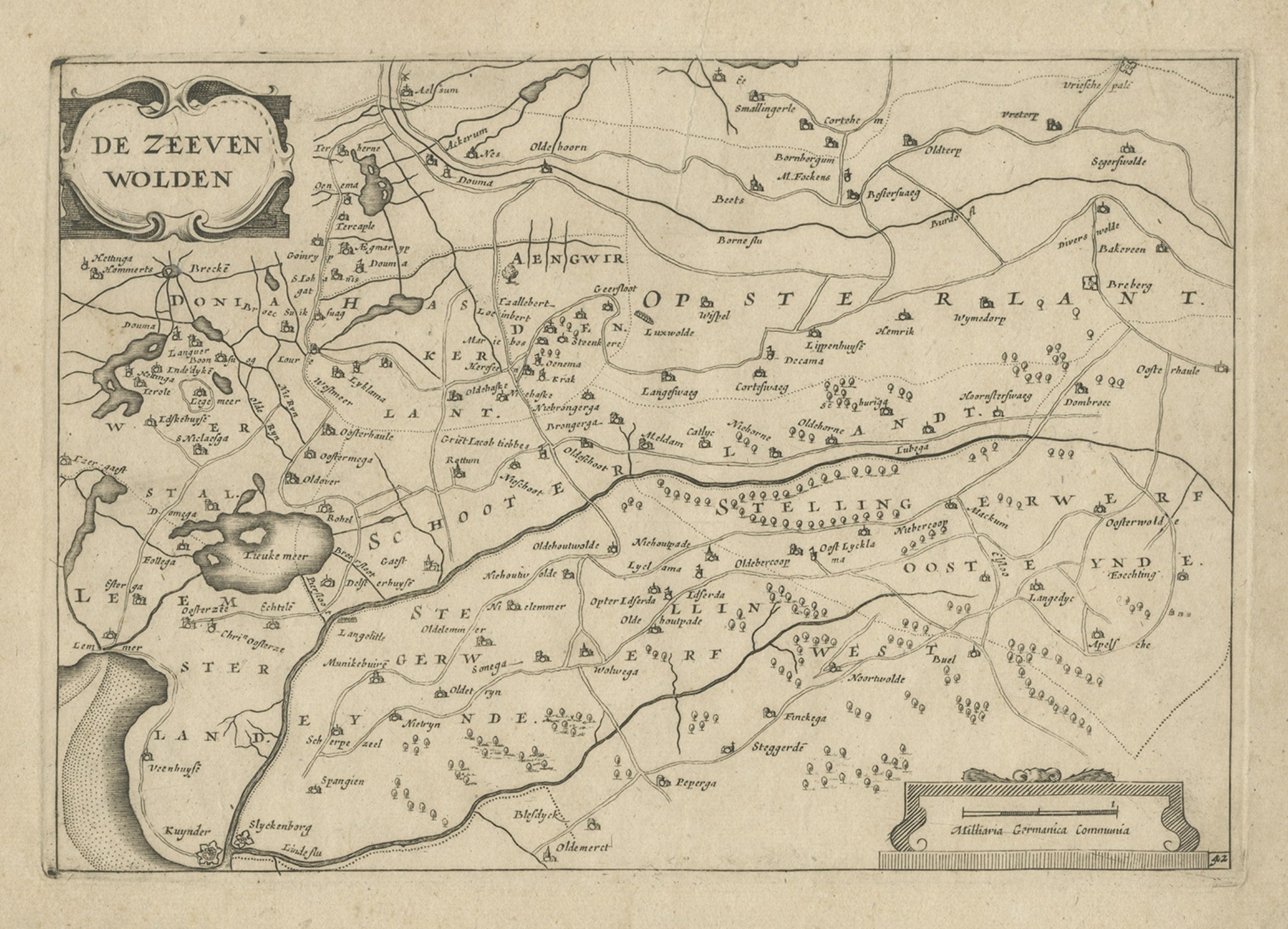
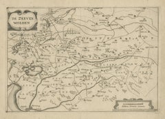
- Antique Map of the Region of Zevenwouden, Friesland, The Netherlands, 1660Located in Langweer, NLAntique map titled 'De Zeeven Wolden'. Map of the region of Zevenwouden (or Zevenwolden) in Friesland, the Netherlands. This region include the villages of Langweer, Echtenerbrug...Category
Antique 17th Century Maps
MaterialsPaper


You May Also Like
- Antique 18th Century Map of the Province of Pensilvania 'Pennsylvania State'Located in Philadelphia, PAA fine antique of the colony of Pennsylvania. Noted at the top of the sheet as a 'Map of the province of Pensilvania'. This undated and anonymous map is thought to be from the Gentleman's Magazine, London, circa 1775, although the general appearance could date it to the 1760's. The southern boundary reflects the Mason-Dixon survey (1768), the western boundary is placed just west of Pittsburgh, and the northern boundary is not marked. The map has a number of reference points that likely refer to companion text and appear to be connected to boundaries. The western and southern boundaries are marked Q, R, S, for example. A diagonal line runs from the Susquehanna R to the Lake Erie P. A broken line marked by many letters A, B, N, O, etc., appears in the east. There are no latitude or longitude markings, blank verso. Framed in a shaped contemporary gilt wooden frame and matted under a cream colored matte. Bearing an old Graham Arader Gallery...Category
Antique 18th Century British American Colonial Maps
MaterialsPaper
- Original Antique Map of The Netherlands, Engraved by Barlow, Dated 1807Located in St Annes, LancashireGreat map of Netherlands Copper-plate engraving by Barlow Published by Brightly & Kinnersly, Bungay, Suffolk. Dated 1807 Unframed.Category
Antique Early 1800s English Maps
MaterialsPaper
- Original Antique Map of The Netherlands, Sherwood, Neely & Jones, Dated 1809Located in St Annes, LancashireGreat map of The Netherlands Copper-plate engraving by Cooper Published by Sherwood, Neely & Jones. Dated 1809 Unframed.Category
Antique Early 1800s English Maps
MaterialsPaper
- Map of the Republic of GenoaLocated in New York, NYFramed antique hand-coloured map of the Republic of Genoa including the duchies of Mantua, Modena, and Parma. Europe, late 18th century. Dimension: 25...Category
Antique Late 18th Century European Maps
- Map "Estuary- Mouth of the Thames"Located in Alessandria, PiemonteST/426 - Antique French Map of the estuary of the Thames, map dated 1769 - "Mape of the entrance of the Thames. Designed by filing of Navy cards fo...Category
Antique Mid-18th Century French Other Prints
MaterialsPaper
- Vintage "View of the Center of Paris Taken from the Air" Lithograph MapLocated in San Diego, CAA very stylish "View of the Center of Paris Taken from the Air" lithograph map published by the Paris Ministry of Tourism, circa early 1950s. The piece measures 27" x 43" and shows...Category
20th Century French Mid-Century Modern Prints
MaterialsPaper


Recently Viewed
View AllMore Ways To Browse
Netherlands 16th Century
Antique State Maps
17th Century World Map
Antique 17th Century World Map
Netherlands 16th Century
Antique Furniture In Texas
Antique Maps Of England
Antique Map Of England
Antique Furniture North East
Natural History Curiosities
Antique United States Maps
Antique Map United States
United States Map Antique
Antique United States Map
Antique Western Collectibles
Antique Railroad
Railroad Antique
Antique Maps Of United States