Items Similar to Large Decorative Antique Map of the Mediterranean, ca.1770


Want more images or videos?
Request additional images or videos from the seller
1 of 5
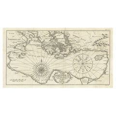
Large Decorative Antique Map of the Mediterranean, ca.1770
$1,093.65
$1,367.0620% Off
£813.57
£1,016.9620% Off
€912
€1,14020% Off
CA$1,497.58
CA$1,871.9820% Off
A$1,665.11
A$2,081.3820% Off
CHF 869.43
CHF 1,086.7820% Off
MX$20,268.42
MX$25,335.5220% Off
NOK 11,093.52
NOK 13,866.9020% Off
SEK 10,394.09
SEK 12,992.6220% Off
DKK 6,942.55
DKK 8,678.1920% Off
Shipping
Retrieving quote...The 1stDibs Promise:
Authenticity Guarantee,
Money-Back Guarantee,
24-Hour Cancellation
About the Item
Antique map titled 'Carte de la Mer Mediterranee en Douze Feuilles'.
First map out of twelve fine engraved double-page and folding maps that join to create a large wall map of the Mediterranean. The detailed charts show depths, ports, fortifications and towns of the entire Mediterranean coast: for Cadiz and the Strait of Gibraltar to Oran and Tunis; Algeria and the Balearic Islands; Languedoc to Corsica and Elba; Tyrrhenian Sea; Minorca, Sardinia and Tunisia; Sicily, Malta and Libya; Adriatic Sea; Libya; Crete, Libya and Egypt; south of Turkey, Cyprus, Palestine and Egypt; south of the Egadi Islands and Crete; and north of the Egadi Islands and the Dardanelles.
Artists and Engravers: Joseph Roux owned a chart-publishing and selling business in Marseilles during the middle and latter part of the eighteenth century. A copy of this atlas was used aboard Nelson's flagship, HMS Victory, in 1802 and 1803 - a fact which shows that the Royal Navy was relying on British and foreign privately printed charts even after Alexander Dalrymple had established the Admiralty Hydrographic Office in 1795.
- Dimensions:Height: 22.25 in (56.5 cm)Width: 32.29 in (82 cm)Depth: 0 in (0.02 mm)
- Materials and Techniques:
- Period:1770-1779
- Date of Manufacture:circa 1770
- Condition:Repaired: Several repairs with tape, visible on verso. Condition: Good. General age-related toning. Several repairs with tape, visible on verso. Please study image carefully.
- Seller Location:Langweer, NL
- Reference Number:Seller: BG-049111stDibs: LU3054327382102
About the Seller
5.0
Recognized Seller
These prestigious sellers are industry leaders and represent the highest echelon for item quality and design.
Platinum Seller
Premium sellers with a 4.7+ rating and 24-hour response times
Established in 2009
1stDibs seller since 2017
2,510 sales on 1stDibs
Typical response time: <1 hour
- ShippingRetrieving quote...Shipping from: Langweer, Netherlands
- Return Policy
Authenticity Guarantee
In the unlikely event there’s an issue with an item’s authenticity, contact us within 1 year for a full refund. DetailsMoney-Back Guarantee
If your item is not as described, is damaged in transit, or does not arrive, contact us within 7 days for a full refund. Details24-Hour Cancellation
You have a 24-hour grace period in which to reconsider your purchase, with no questions asked.Vetted Professional Sellers
Our world-class sellers must adhere to strict standards for service and quality, maintaining the integrity of our listings.Price-Match Guarantee
If you find that a seller listed the same item for a lower price elsewhere, we’ll match it.Trusted Global Delivery
Our best-in-class carrier network provides specialized shipping options worldwide, including custom delivery.More From This Seller
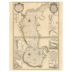
View AllAntique Map of the Coast of Southern France, 1793
Located in Langweer, NL
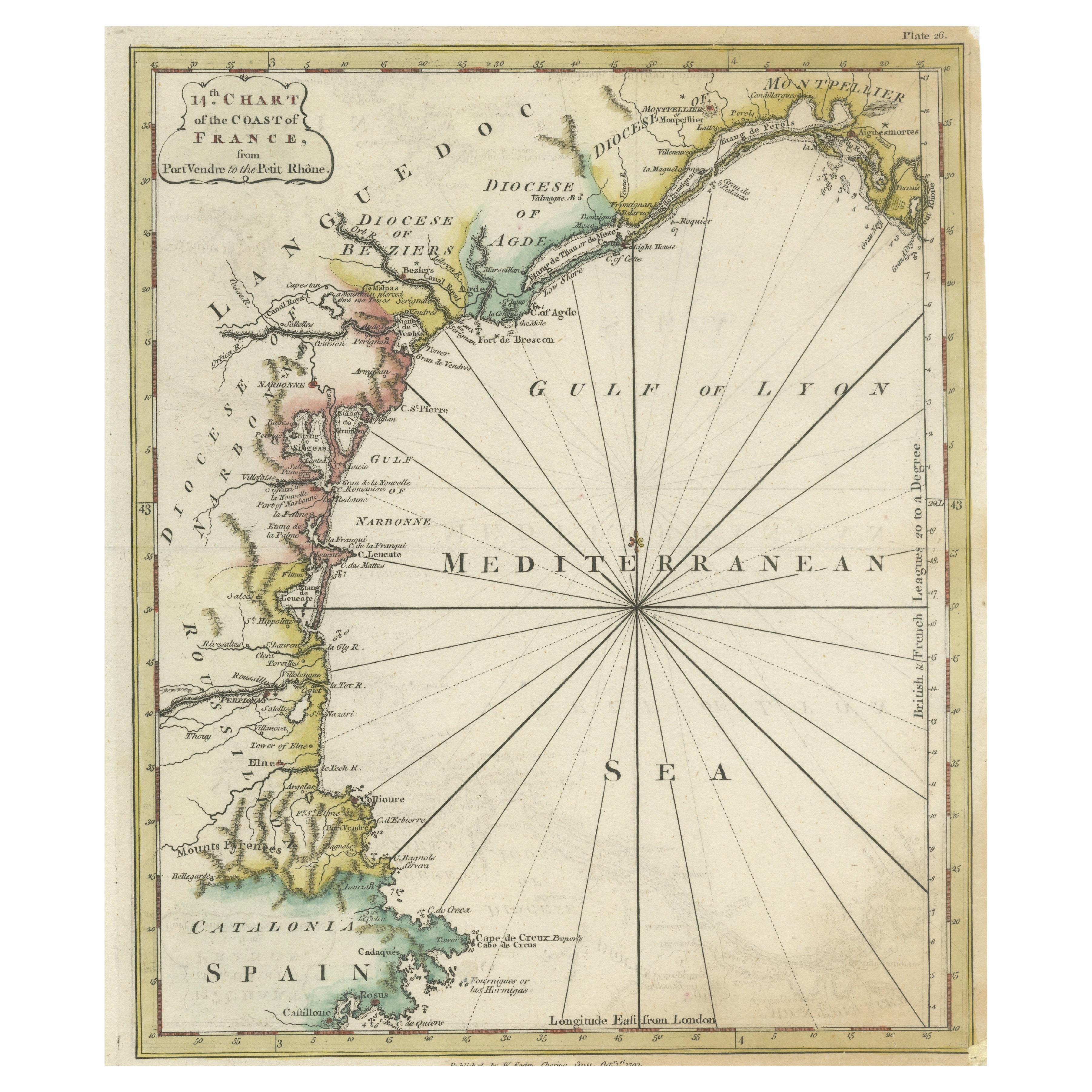
Antique map titled '14th Chart of the Coast of France, from Port Vendres to the Petit Rhône'. Original map with later hand coroling of the coast of Southern France.
The "14th Chart of the Coast of France, from Port Vendres to the Petit Rhône" is an antique map that offers a detailed depiction of the southern coast of France, specifically highlighting the Mediterranean coastline. This map, which dates back to 1793, was originally part of "Le Petit Neptune Français; Or, French Coasting Pilot," a publication designed for maritime navigation along the French coastlines.
Key Features of the Map:
1. **Geographic Coverage**:
- The map covers the southern French coastline from Port Vendres in the west to the Petit Rhône in the east.
- It includes notable regions such as Languedoc, the Gulf of Lyon, and parts of Catalonia (Spain).
2. **Notable Places**:
- **Montpellier**: A major city in the Diocese of Montpellier, an important cultural and economic center.
- **Narbonne**: Located in the Diocese of Narbonne, a historical city with Roman heritage.
- **Agde**: Situated in the Diocese of Agde, known for its ancient Greek colony origins.
- **Béziers**: Part of the Diocese of Béziers, another city with deep historical roots dating back to Roman times.
- **Port Vendres**: A critical port near the Spanish border.
- **Catalonia**: Including parts of northeastern Spain, emphasizing the coastal connection between France and Spain.
3. **Dioceses and Regions**:
- The map is marked with various dioceses such as Montpellier, Agde, Narbonne, and Béziers, indicating ecclesiastical boundaries.
- It highlights the broader region of Languedoc, a historical province known for its wine production and medieval history.
4. **Navigational Aids**:
- The map features a compass rose with radiating lines, a common navigational aid in maritime maps...
Category
Antique Late 18th Century Maps
Materials
Paper

$230 Sale Price
20% Off
Old Dutch Map of the Region Around the Mediterranean Sea, 1773
Located in Langweer, NL
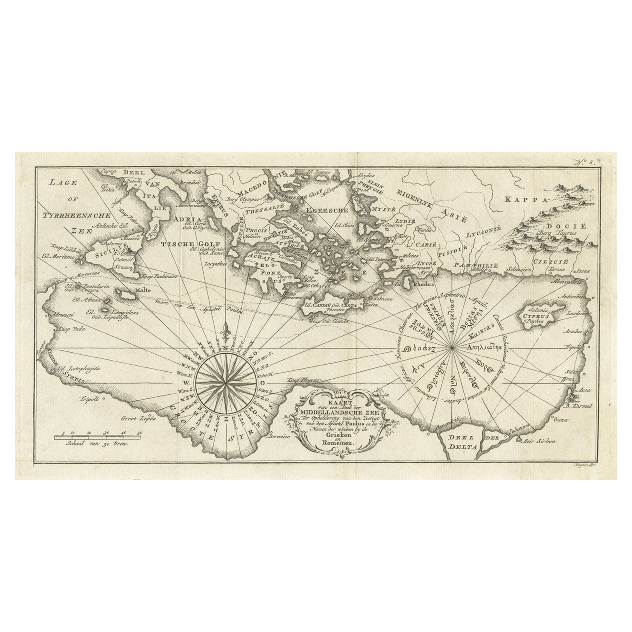
Antique map titled 'Kaart van een Deel der Middelandsche Zee (..)'.
Old map of the region around the Mediterranean Sea. Originates from the first Dutch editon of an interesting t...
Category
Antique 1770s Maps
Materials
Paper
$345 Sale Price
20% Off
Original Antique Engraving of a Sea Chart of the Western Mediterranean, ca.1650
Located in Langweer, NL
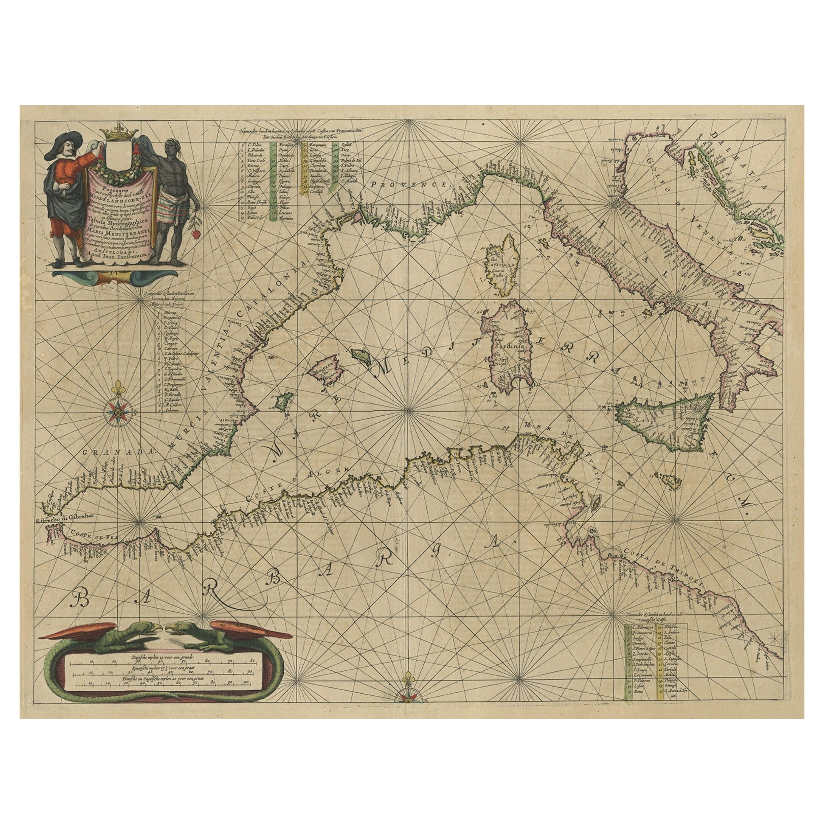
Antique map titled 'Pascaerte van 't westlyckste deel vande Middelandsche-Zee (..)'.
Sea chart of the Western Mediterranean. The map extends from the Straits of Gibralter to Italy ...
Category
Antique 1650s Maps
Materials
Paper

$1,198 Sale Price
20% Off
Antique Map of the Mediterranean Sea and Surroundings by Keizer & de Lat, 1788
Located in Langweer, NL
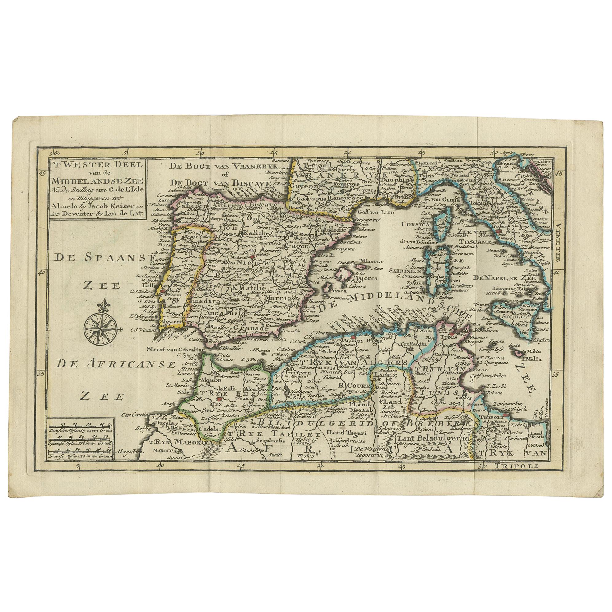
Antique map titled 't Wester Deel van de Middelandse Zee (..)'. Uncommon original antique map of the Mediterranean Sea and surroundings. This map originates from 'Nieuwe Natuur- Gesc...
Category
Antique Late 18th Century Maps
Materials
Paper

$335 Sale Price
20% Off
Antique Map of the Northern Coast of Africa and Southern Europe, circa 1745
By Covens & Mortier
Located in Langweer, NL
Antique map titled 'In Notitiam Ecclesiasticam Africae Tabula Geographica'. Very decorative hand-colored map of the northern coast of Africa, Spain, Italy and the Mediterranean with the islands of Sardinia, Corsica, Majorca, Minorca etc. Sicily features a smoking Mount Aetna. Embellished with three architectural cartouches...
Category
Antique Mid-18th Century Maps
Materials
Paper

$306 Sale Price
67% Off
Fabulous Original Antique two-sheet Map of the Caspian Sea, ca.1723
Located in Langweer, NL
Carte Marine de la Mer Caspiene... [and] Coste de Perse sur la Mer Caspiene et Partie de Celles de Tartarie", Delisle, Guillaume (2 maps)
Subject: Caspian Sea
...
Category
Antique 1720s Maps
Materials
Paper
$2,110 Sale Price
20% Off
You May Also Like
Southern Greece: A Large 17th C. Hand-colored Map by Sanson and Jaillot
By Nicolas Sanson
Located in Alamo, CA
This large original hand-colored copperplate engraved map of southern Greece and the Pelopponese Peninsula entitled "La Moree Et Les Isles De Zante, Cefalonie, Ste. Marie, Cerigo & C...
Category
Antique 1690s French Maps
Materials
Paper

Original Antique Map of South America. C.1780
Located in St Annes, Lancashire
Great map of South America
Copper-plate engraving
Published C.1780
Two small worm holes to left side of map
Unframed.
Category
Antique Early 1800s English Georgian Maps
Materials
Paper

Mediterranean and Adriatic Seas: Original 18th Century Hand-colored Map by Bowen
Located in Alamo, CA
This is an original 18th century hand-colored map entitled "An Accurate Chart of The Mediterranean and Adriatic Sea's; with the Archipelago & Part of the Black Sea. Exhibiting all th...
Category
Mid-18th Century Old Masters Landscape Prints
Materials
Engraving

Antique Map - Gallia - Etching by Johannes Janssonius - 1650s
By Johannes Janssonius
Located in Roma, IT
Antique Map - Gallia is an antique map realized in 1650 by Johannes Janssonius (1588-1664).
The Map is Hand-colored etching, with coeval watercoloring.
Good conditions with slight ...
Category
1650s Modern Figurative Prints
Materials
Etching

Plymouth, England: A Hand-Colored 17th Century Sea Chart by Captain Collins
By Captain Greenvile Collins
Located in Alamo, CA
This hand-colored sea chart of the area around Plymouth, England from "Great Britain's Coasting Pilot. Being a New and Exact Survey of the Sea-Coast of England", first published in 1...
Category
Antique Late 17th Century English Maps
Materials
Paper

Large Framed Map of the Mediterranean
Located in Queens, NY
Large map/chart chart of The Mediterranean and the Grecian Archipelago showing Italy, Sardinia, Corsica, part of France, etc. in a black frame.
Category
20th Century French Mid-Century Modern Maps
More Ways To Browse
Mediterranean Antique
Royal Navy Antique
Large Wall Maps
Antique Crete
Antique Maltese Furniture
Malta Antique
Sardinia Map
Gibraltar Antique Map
Hms Victory
Map Of Palestine
Antique Maps Of Malta
Antique Map Palestine
Tunisia Antique Map
Alexander Roux
Antique Map Of Thailand
Antique Mississippi Map
Antique Ohio Maps
Burgundy Map