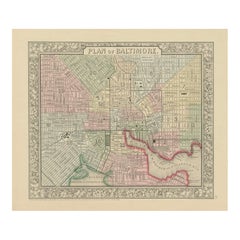
Items Similar to Large Original Antique City Plan of Baltimore, USA, 1894
Want more images or videos?
Request additional images or videos from the seller
1 of 5
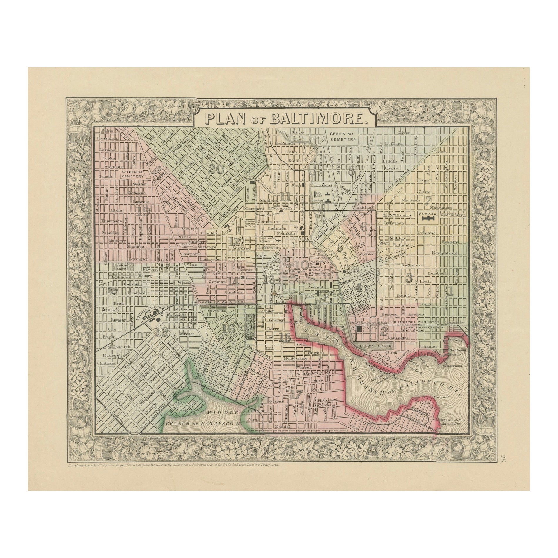
Large Original Antique City Plan of Baltimore, USA, 1894
$90
£68.81
€79.25
CA$126.12
A$140.80
CHF 73.78
MX$1,723.51
NOK 936.96
SEK 883.43
DKK 591.49
About the Item
Fabulous colorful map of Baltimore
Original color
By Rand, McNally & Co.
Published, 1894
Unframed
Free shipping.
- Creator:Rand McNally & Co. (Maker)
- Dimensions:Height: 26.75 in (67.95 cm)Width: 20.5 in (52.07 cm)Depth: 0.07 in (1.78 mm)
- Materials and Techniques:Paper,Other
- Place of Origin:
- Period:
- Date of Manufacture:1894
- Condition:Wear consistent with age and use.
- Seller Location:St Annes, GB
- Reference Number:1stDibs: LU1836328810752
About the Seller
4.9
Platinum Seller
Premium sellers with a 4.7+ rating and 24-hour response times
1stDibs seller since 2016
3,116 sales on 1stDibs
Typical response time: 1 hour
Associations
International Confederation of Art and Antique Dealers' Associations
- ShippingRetrieving quote...Shipping from: St Annes, United Kingdom
- Return Policy
Authenticity Guarantee
In the unlikely event there’s an issue with an item’s authenticity, contact us within 1 year for a full refund. DetailsMoney-Back Guarantee
If your item is not as described, is damaged in transit, or does not arrive, contact us within 7 days for a full refund. Details24-Hour Cancellation
You have a 24-hour grace period in which to reconsider your purchase, with no questions asked.Vetted Professional Sellers
Our world-class sellers must adhere to strict standards for service and quality, maintaining the integrity of our listings.Price-Match Guarantee
If you find that a seller listed the same item for a lower price elsewhere, we’ll match it.Trusted Global Delivery
Our best-in-class carrier network provides specialized shipping options worldwide, including custom delivery.More From This Seller
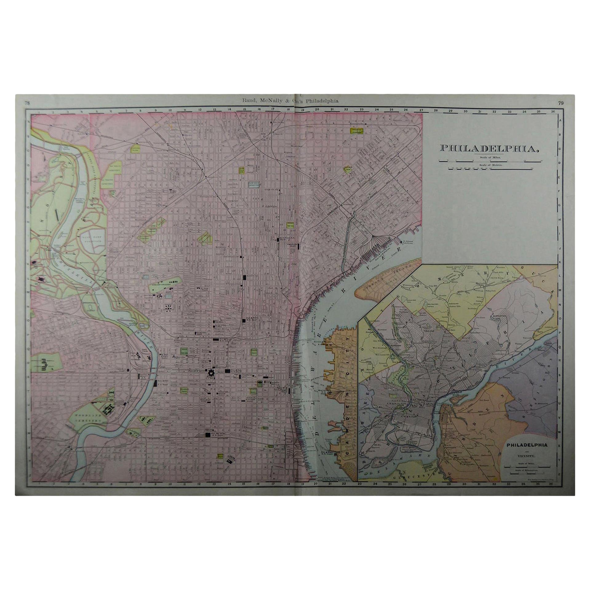
View AllLarge Original Antique City Plan of Philadelphia, USA, circa 1900
By Rand McNally & Co.
Located in St Annes, Lancashire
Fabulous colorful map of Philadelphia
Original color
By Rand, McNally & Co.
Published, circa 1900.
Unframed
Free shipping.
Category
Antique Early 1900s American Maps
Materials
Paper

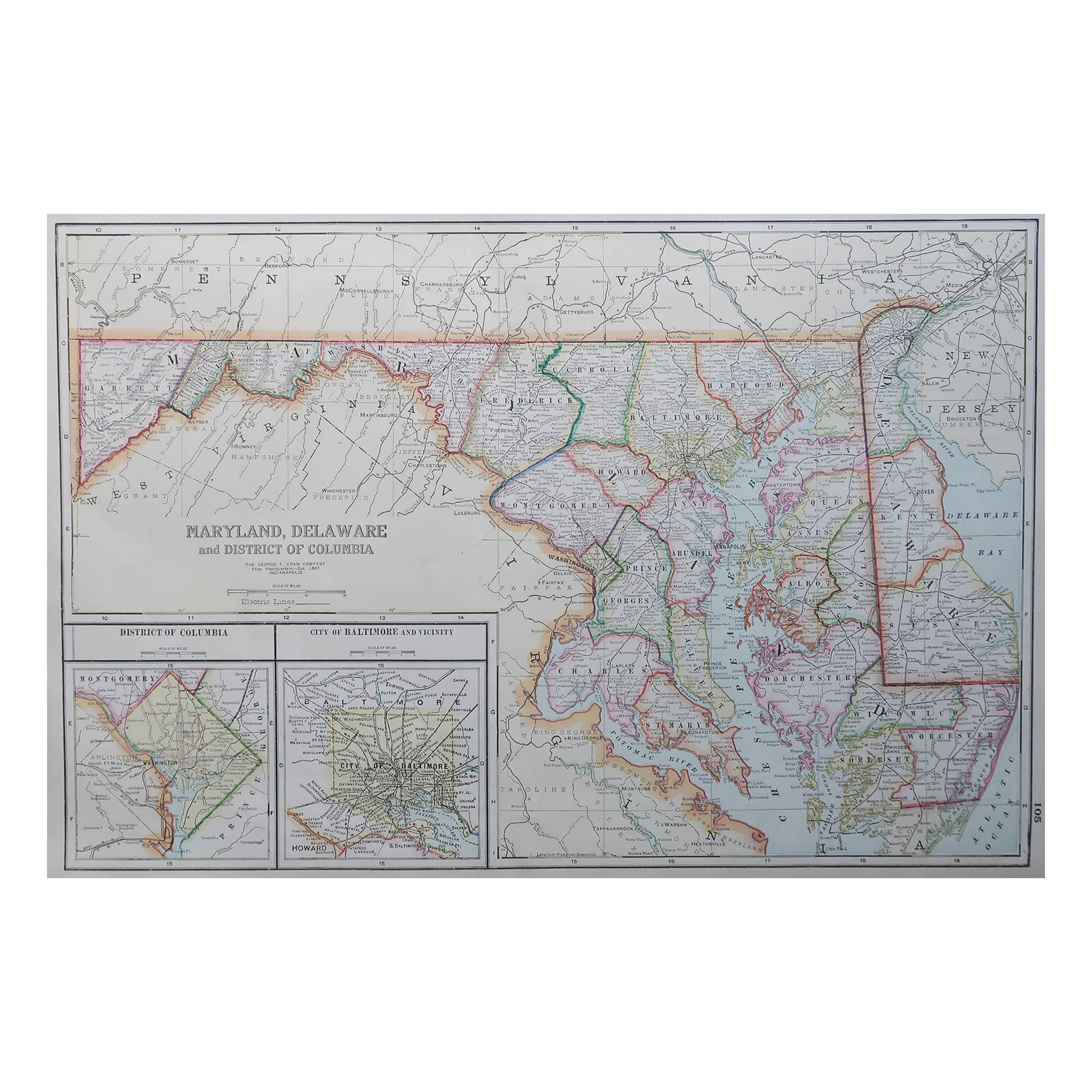
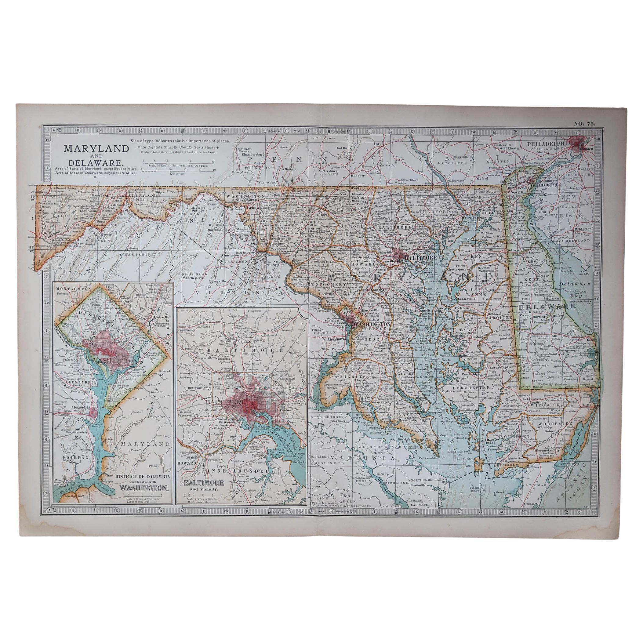
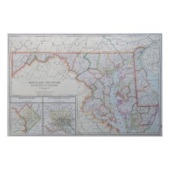
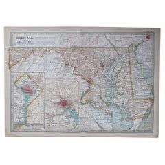
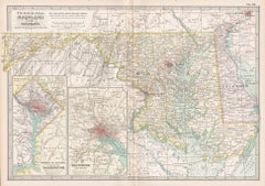
Large Original Antique Map of Maryland, Delaware & DC, USA, C.1900
Located in St Annes, Lancashire
Fabulous map of Maryland, Delaware And District of Columbia
Original color
Engraved and printed by the George F. Cram Company, Indianapolis.
Pu...
Category
Antique 1890s American Maps
Materials
Paper
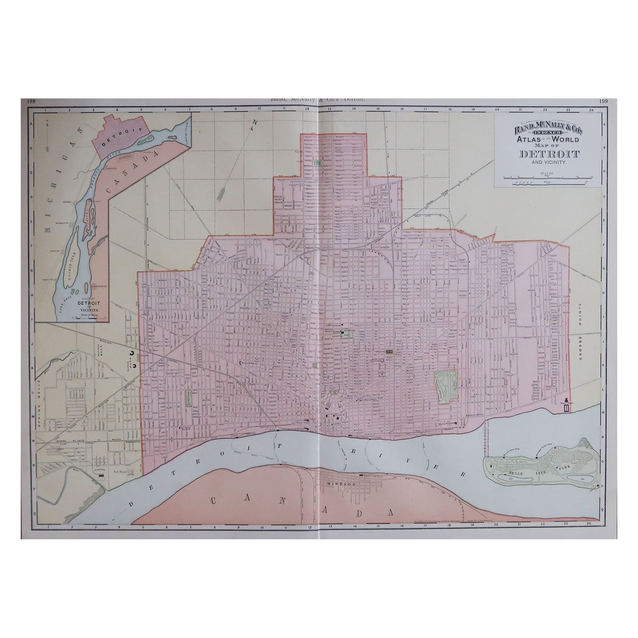
Large Original Antique City Plan of Detroit, USA, 1894
By Rand McNally & Co.
Located in St Annes, Lancashire
Fabulous colorful map of Detroit
Original color
By Rand, McNally & Co.
Published, 1894
Unframed
Free shipping.
Category
Antique 1890s American Maps
Materials
Paper
Original Antique Map of the American State of Maryland & Delaware, 1903
Located in St Annes, Lancashire
Antique map of Maryland And Delaware
Published By A & C Black. 1903
Original colour
Good condition
Unframed.
Free shipping
Category
Antique Early 1900s English Maps
Materials
Paper
Large Original Antique City Plan of Montreal, Canada, circa 1900
By Rand McNally & Co.
Located in St Annes, Lancashire
Fabulous colorful map of Montreal
Original color
By Rand, McNally & Co.
Published, circa 1900
Unframed
Minor edge tears
Free shipping.
Category
Antique Early 1900s American Maps
Materials
Paper

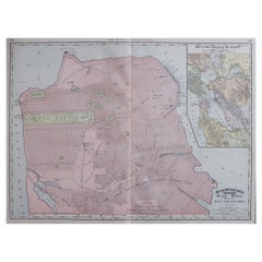
Large Original Antique City Plan of San Francisco, USA, 1894
By Rand McNally & Co.
Located in St Annes, Lancashire
Fabulous colorful map of San Francisco
Original color
By Rand, McNally & Co.
Published, 1894
Unframed
Free shipping.
Category
Antique 1890s American Maps
Materials
Paper
You May Also Like
Plan of Baltimore City Map, USA c.1870 – Hand-Colored Street Plan
Located in Langweer, NL
Plan of Baltimore City Map, USA c.1870 – Hand-Colored Street Plan
This is a finely engraved and hand-colored street plan titled Plan of Baltimore, published in the United States cir...
Category
Antique Mid-19th Century American Maps
Materials
Paper
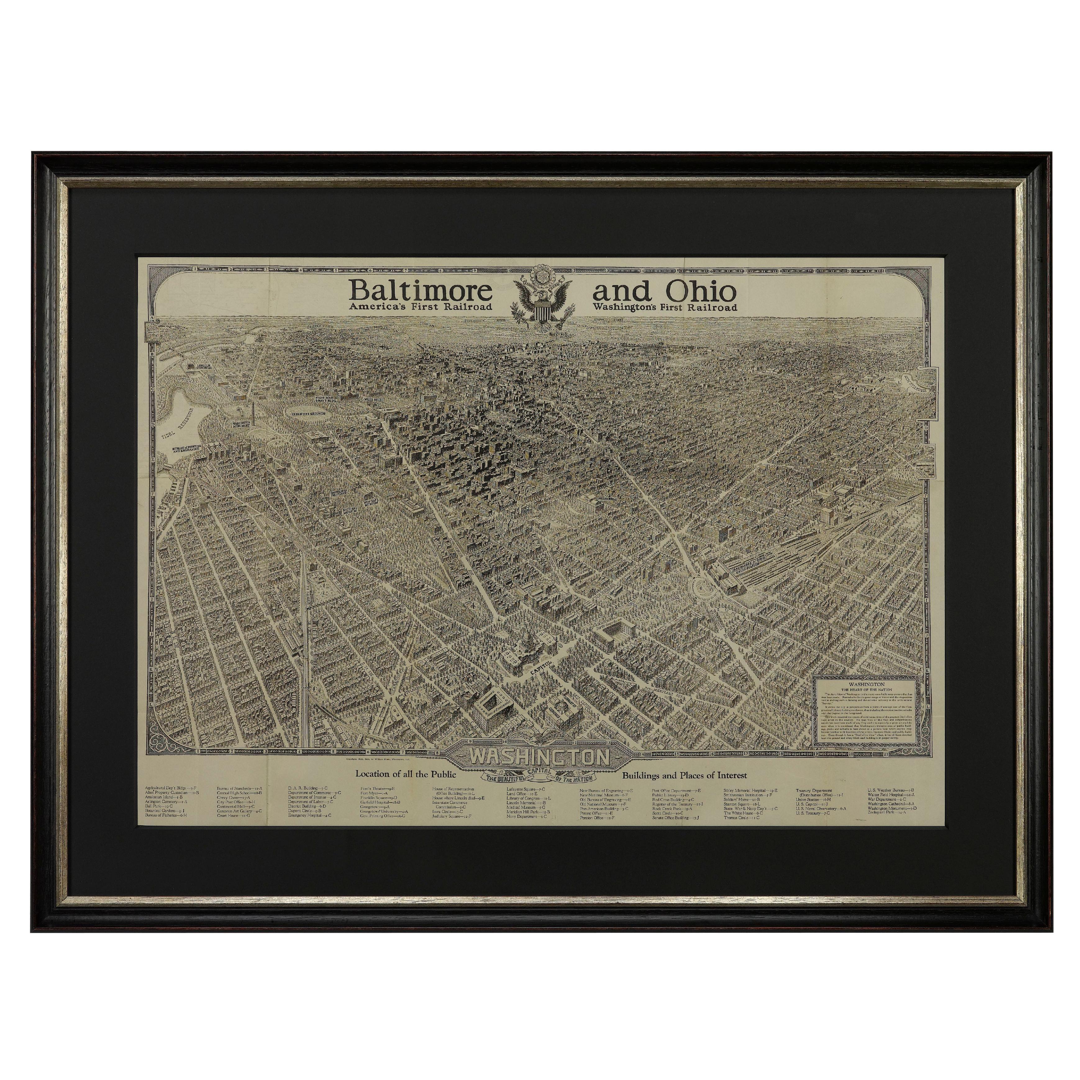
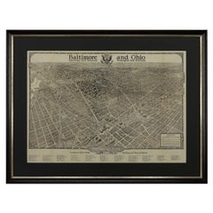
1923 "Washington, The Beautiful Capital of the Nation" Baltimore and Ohio RR Map
Located in Colorado Springs, CO
This is a fabulous 1923 bird's eye map of Washington, DC that shows the city in amazing detail. Every building is individually drawn and all major roads in the city are shown. The vi...
Category
Vintage 1920s American Art Deco Maps
Materials
Paper
Maryland and Delaware. USA. Century Atlas state antique vintage map
Located in Melbourne, Victoria
'The Century Atlas. Maryland and Delaware.'
Original antique map, 1903.
Central fold as issued. Map name and number printed on the reverse corners.
Sheet 29.5cm by 40cm.
Category
Early 20th Century Victorian More Prints
Materials
Lithograph
1840 Map of the City of Washington Published by William M. Morrison
Located in Colorado Springs, CO
This map, printed in 1840, is a detailed representation of Washington, D.C. in the mid-19th century. The map shows block numbers, wards, and government buildings as well as details o...
Category
Antique 1840s American Federal Maps
Materials
Paper

Antique Map of St. Louis and Chicago
Located in Langweer, NL
Antique map titled 'The City of St. Louis Missouri - The City of Chicago Illinois'. Dual map on single page showing St. Louis and Chicago. Finely produ...
Category
Antique Mid-19th Century Maps
Materials
Paper

$141 Sale Price
20% Off
Antique Map of Virginia, with Inset Map of the South Western Continuation
Located in Langweer, NL
Antique map titled 'Virginia'. Original antique map of Virginia, United States. With inset map of the south western continuation of Virginia. T...
Category
Antique Late 19th Century Maps
Materials
Paper
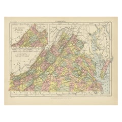
$274 Sale Price
20% Off
More Ways To Browse
Baltimore Antique Furniture
Antique Map Of Yorkshire
Antique Map Vietnam
Antique Maps Massachusetts
Guyana Antique Map
Peninsular War
Santa Cruz Island
Ukraine Antique Map
Antique Life Buoy
Antique Map Nova Scotia
Antique Map Of Argentina
Antique Maps Of Kansas
Cambodia Antique Map
Magellan Map
Map Ukraine
Mariners Chart
Papua New Guinea Antique Map
Bermuda Map