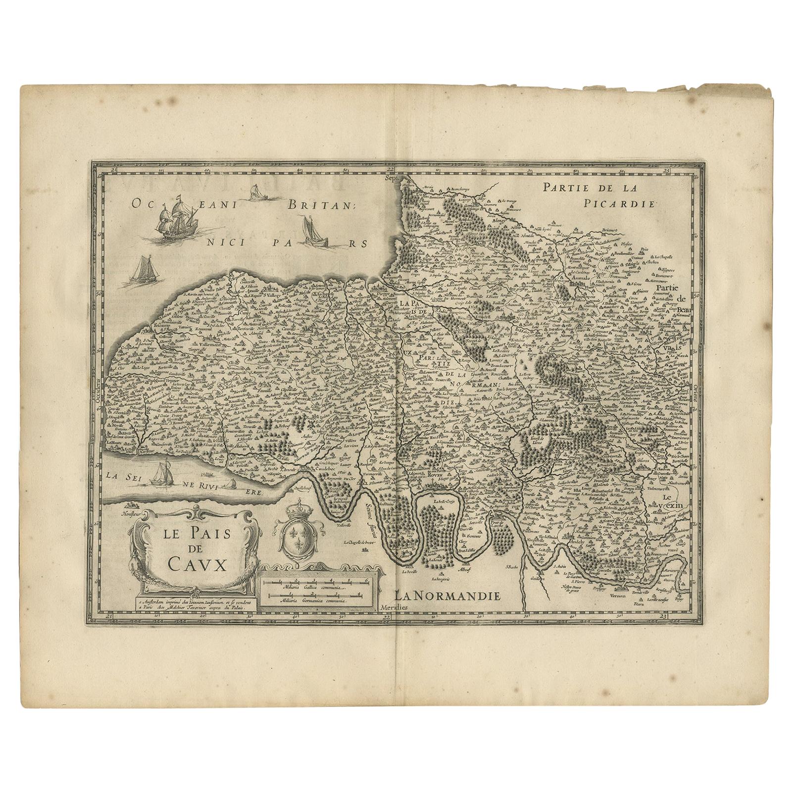
Items Similar to Old Handcolored Antique Map of Pays De Caux in Normandy, France, ca.1640


Want more images or videos?
Request additional images or videos from the seller
1 of 5
Old Handcolored Antique Map of Pays De Caux in Normandy, France, ca.1640
$1,294
$1,617.4920% Off
£963.30
£1,204.1220% Off
€1,080
€1,35020% Off
CA$1,772.45
CA$2,215.5620% Off
A$1,971.35
A$2,464.1920% Off
CHF 1,029.38
CHF 1,286.7220% Off
MX$23,989.25
MX$29,986.5620% Off
NOK 13,146.73
NOK 16,433.4120% Off
SEK 12,329.31
SEK 15,411.6420% Off
DKK 8,221.66
DKK 10,277.0820% Off
Shipping
Retrieving quote...The 1stDibs Promise:
Authenticity Guarantee,
Money-Back Guarantee,
24-Hour Cancellation
About the Item
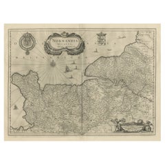
Antique map titled 'Le Pais de Caux'.
Old map of Pays de Caux, France. Pays de Caux is an area in Normandy occupying the greater part of the French département of Seine Maritime in Normandy. It is a chalk plateau to the north of the Seine Estuary and extending to the cliffs on the English Channel coast; its coastline is known as the Côte d'Albâtre. The principal settlements are Le Havre, Dieppe, Fécamp, Yvetot and Étretat. This map originates from a composite atlas.
Artists and Engravers: Johannes Janssonius also known as Jan Jansson (1588-1664) was born in Arnhem, Netherlands. His father was a bookseller and publisher (Jan Janszoon the Elder). When he married the daughter of the cartographer Jodocus Hondius he also set up a business as book publisher in Amsterdam. His first map was published in 1616. Around 15 years later he set up a partnership with his brother in law Hondius add issued further editions of the Mercator/Hondius atlas. After his death his heirs still have published several maps. Many of his plates have been acquired by Pieter Schenk and Gerard Valk.
Condition: Good, original/contemporary hand coloring. The old color has made the paper fragile a few small tears. Small worm hole near 'Allezon'. Latin text on verso, please study image carefully.
- Dimensions:Height: 19.49 in (49.5 cm)Width: 23.04 in (58.5 cm)Depth: 0 in (0.02 mm)
- Materials and Techniques:
- Period:1640-1649
- Date of Manufacture:circa 1640
- Condition:Wear consistent with age and use.
- Seller Location:Langweer, NL
- Reference Number:Seller: BG-12380-16 1stDibs: LU3054326789062
About the Seller
5.0
Recognized Seller
These prestigious sellers are industry leaders and represent the highest echelon for item quality and design.
Platinum Seller
Premium sellers with a 4.7+ rating and 24-hour response times
Established in 2009
1stDibs seller since 2017
2,510 sales on 1stDibs
Typical response time: <1 hour
- ShippingRetrieving quote...Shipping from: Langweer, Netherlands
- Return Policy
Authenticity Guarantee
In the unlikely event there’s an issue with an item’s authenticity, contact us within 1 year for a full refund. DetailsMoney-Back Guarantee
If your item is not as described, is damaged in transit, or does not arrive, contact us within 7 days for a full refund. Details24-Hour Cancellation
You have a 24-hour grace period in which to reconsider your purchase, with no questions asked.Vetted Professional Sellers
Our world-class sellers must adhere to strict standards for service and quality, maintaining the integrity of our listings.Price-Match Guarantee
If you find that a seller listed the same item for a lower price elsewhere, we’ll match it.Trusted Global Delivery
Our best-in-class carrier network provides specialized shipping options worldwide, including custom delivery.More From This Seller
View AllAntique Map of the Region of Pays de Caux by Janssonius, 1657
By Johannes Janssonius
Located in Langweer, NL
Antique map 'Le Pais de Caux'. Decorative map of the region of Pays de Caux, France. This map originates from 'Atlas Novus, Sive Theatrum Orbis Orbis Terrarum: In quo Galliae, Helvet...
Category
Antique Mid-17th Century Maps
Materials
Paper

$527 Sale Price
20% Off
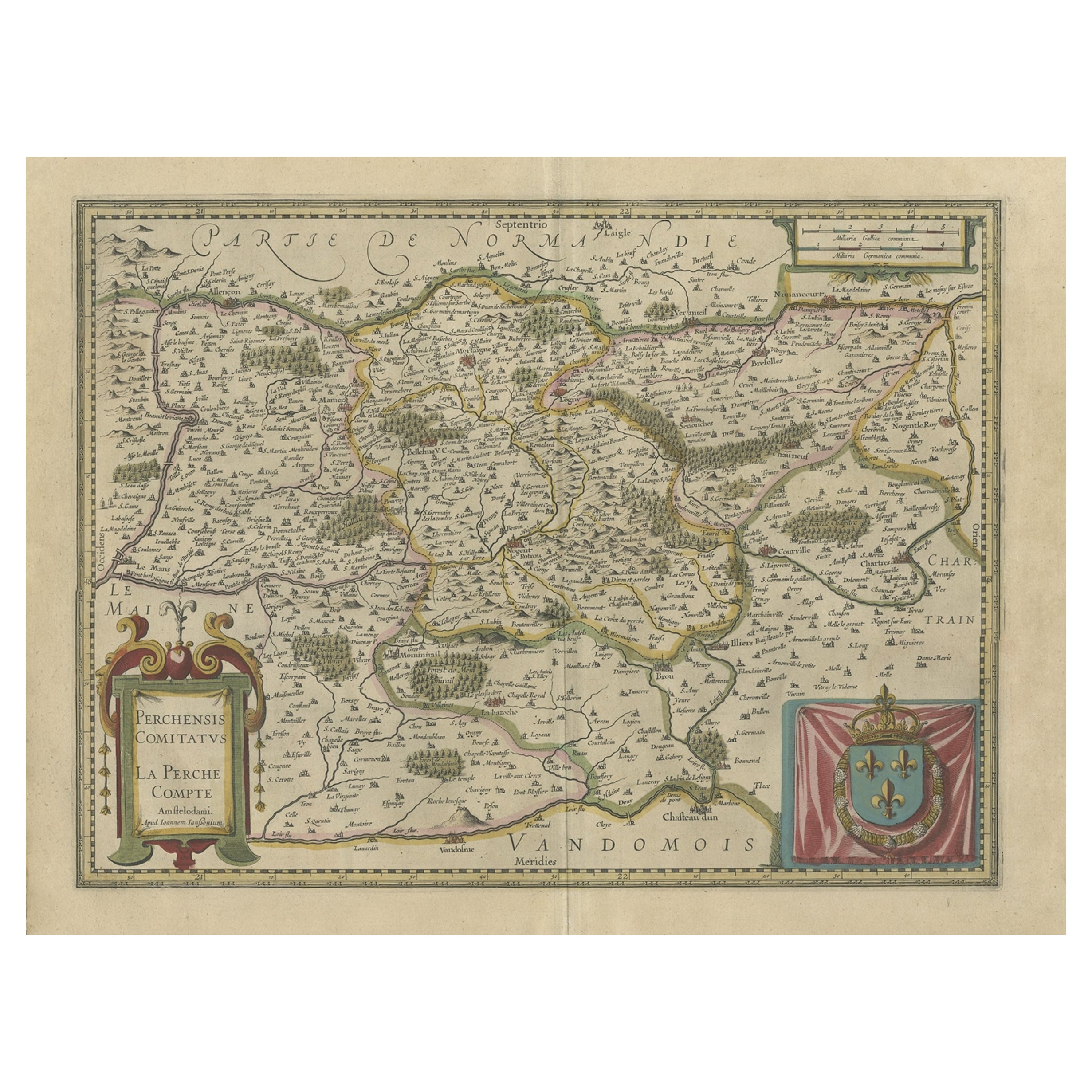
Old Original Handcoloured Map of the Former Province of Perche, France, ca.1640
Located in Langweer, NL
Antique map titled 'Perchensis Comitatus - La Perche compte'.
Old map of the former province of Perche, France. Until the French Revolution, Perche was bounded by four ancient te...
Category
Antique 1640s Maps
Materials
Paper
$690 Sale Price
20% Off
Antique Map of the Region of Lyon by Hondius, circa 1630
Located in Langweer, NL
Antique map titled 'Lionnois, Forest et Beauiolois'. Old map of the former region of Lyon, Vienne, Bresse, Rohan and the Rhône River. This map originates f...
Category
Antique Mid-17th Century Maps
Materials
Paper

$479 Sale Price
20% Off
Hand-Colored 17th-Century Map of Orléanais in France by Frederik De Wit c. 1688
Located in Langweer, NL
Title: Hand-Colored 17th-Century Map of Orléanais by Frederik De Wit c. 1688
Description: This beautifully crafted map, "Gouvernement General du Pays Orléanois," illustrates the Orl...
Category
Antique 1680s Maps
Materials
Paper

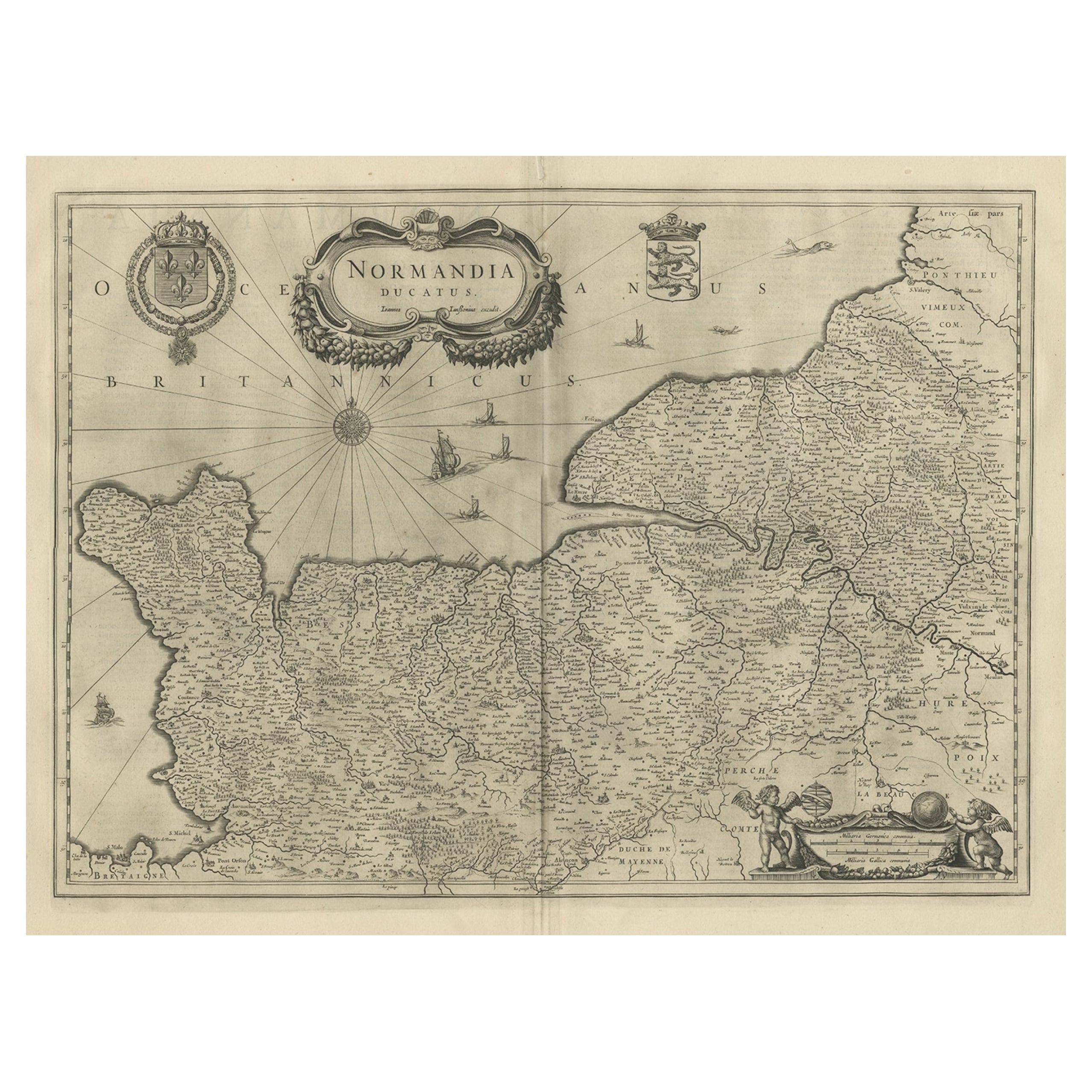
Antique Map of Normandy by Janssonius, 1657
Located in Langweer, NL
Antique map of France titled 'Normandia Ducatus'. Decorative map of the Normandy region, including decorative cartouche, sailing ships and compass rose. This map originates from 'Atl...
Category
Antique 17th Century Maps
Materials
Paper
$343 Sale Price
20% Off
Antique Map of the Picardy Region of France by Ortelius, 'circa 1590'
Located in Langweer, NL
Antique map titled 'Picardiae Belgicae regionis descriptio'. Original antique map of the Picardy region, France. Published by A. Ortelius, circa 1590.
Category
Antique 16th Century Maps
Materials
Paper

$575 Sale Price
20% Off
You May Also Like
17th Century Hand Colored Map of the Liege Region in Belgium by Visscher
By Nicolaes Visscher II
Located in Alamo, CA
An original 17th century map entitled "Leodiensis Episcopatus in omnes Subjacentes Provincias distincté divisusVisscher, Leodiensis Episcopatus" by Nicolaes Visscher II, published in Amsterdam in 1688. The map is centered on Liege, Belgium, includes the area between Antwerp, Turnhout, Roermond, Cologne, Trier and Dinant.
This attractive map is presented in a cream-colored mat measuring 30" wide x 27.5" high. There is a central fold, as issued. There is minimal spotting in the upper margin and a tiny spot in the right lower margin, which are under the mat. The map is otherwise in excellent condition.
The Visscher family were one of the great cartographic families of the 17th century. Begun by Claes Jansz Visscher...
Category
Antique Late 17th Century Dutch Maps
Materials
Paper

The Normandy Region of France: A 17th C. Hand-colored Map by Sanson and Jaillot
By Nicolas Sanson
Located in Alamo, CA
This large hand-colored map entitled "Le Duché et Gouvernement de Normandie divisée en Haute et Basse Normandie en divers Pays; et par evêchez, avec le Gouvernement General du Havre ...
Category
Antique 1690s French Maps
Materials
Paper

17th Century Hand-Colored Map of a Region in West Germany by Janssonius
By Johannes Janssonius
Located in Alamo, CA
This attractive highly detailed 17th century original hand-colored map is entitled "Archiepiscopatus Maghdeburgensis et Anhaltinus Ducatus cum terris adjacentibus". It was published ...
Category
Antique Mid-17th Century Dutch Maps
Materials
Paper

1630 Pierre Petit map "Description du Gouvernement de la Capelle" Ric0010
Located in Norton, MA
1630 Pierre Petit map entitled
"Description du Gouvernement de la Capelle,"
Ric0010
Pierre Petit was the son of a minor provincial official in Montluçon. The town, in the Auver...
Category
Antique 17th Century Dutch Maps
Materials
Paper

Prussia, Poland, N. Germany, Etc: A Hand-colored 17th Century Map by Janssonius
By Johannes Janssonius
Located in Alamo, CA
This is an attractive hand-colored copperplate engraved 17th century map of Prussia entitled "Prussia Accurate Descripta a Gasparo Henneberg Erlichensi", published in Amsterdam by Joannes Janssonius in 1664. This very detailed map from the golden age of Dutch cartography includes present-day Poland, Latvia, Lithuania, Estonia and portions of Germany. This highly detailed map is embellished by three ornate pink, red, mint green and gold...
Category
Antique Mid-17th Century Dutch Maps
Materials
Paper

1640 Joan Bleau Map Entitled"Diocecese de rheims et le pais de rethel, " Eic.a011
Located in Norton, MA
1640 Joan Bleau map entitled
"Diocecese de rheims et le pais de rethel,"
Ric.a011
OAN BLAEU
Diocecese de Rheims, et le pais de Rethel.
Handcolored engraving, c.1640.
...
Category
Antique 17th Century Dutch Maps
Materials
Paper

More Ways To Browse
Map Of Normandy
Antique Navigational Tools
Antique German Compass
Key Trade Sign
Spanish Galleon
World Map Of Trade Routes
Antique Puerto Rico
Albanian Antique
Antique Furniture Wiltshire
Antique Maps Of Israel
Framed Africa Maps
Antique Furniture Goa
Croatian Antiques
Map Of Israel
Teak Sphere
18th Century Scottish Collectibles
Map Of Mexican California
Ottoman Map