Items Similar to Old Map of the Gulf of Bothnia, the Northernmost Arm of the Baltic Sea, 1759


Want more images or videos?
Request additional images or videos from the seller
1 of 6
Old Map of the Gulf of Bothnia, the Northernmost Arm of the Baltic Sea, 1759
$226.84
$283.5520% Off
£170.03
£212.5420% Off
€192
€24020% Off
CA$311.64
CA$389.5520% Off
A$347.91
A$434.8920% Off
CHF 182.30
CHF 227.8820% Off
MX$4,258.82
MX$5,323.5220% Off
NOK 2,315.24
NOK 2,894.0520% Off
SEK 2,182.98
SEK 2,728.7220% Off
DKK 1,461.57
DKK 1,826.9720% Off
Shipping
Retrieving quote...The 1stDibs Promise:
Authenticity Guarantee,
Money-Back Guarantee,
24-Hour Cancellation
About the Item
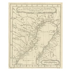
Antique map titled 'Carte du Golphe de Bothnie'.
Original antique map of the Gulf of Bothnia, the northernmost arm of the Baltic Sea. It is situated between Finland's west coast (Ostrobothnia) and Sweden's east coast (Westrobothnia and North Bothnia). This print originates from volume 19 of 'Histoire generale des voyages (..)' by Antoine Francois Prevost d'Exile.
Artists and Engravers: Published by Didot.
- Dimensions:Height: 9.85 in (25 cm)Width: 7.49 in (19 cm)Depth: 0 in (0.02 mm)
- Materials and Techniques:
- Period:1750-1759
- Date of Manufacture:1759
- Condition:Condition: Very good, general age-related toning. Minor wear and soiling, blank verso. Please study image carefully.
- Seller Location:Langweer, NL
- Reference Number:Seller: BG-12645-121stDibs: LU3054327295012
About the Seller
5.0
Recognized Seller
These prestigious sellers are industry leaders and represent the highest echelon for item quality and design.
Platinum Seller
Premium sellers with a 4.7+ rating and 24-hour response times
Established in 2009
1stDibs seller since 2017
2,511 sales on 1stDibs
Typical response time: <1 hour
- ShippingRetrieving quote...Shipping from: Langweer, Netherlands
- Return Policy
Authenticity Guarantee
In the unlikely event there’s an issue with an item’s authenticity, contact us within 1 year for a full refund. DetailsMoney-Back Guarantee
If your item is not as described, is damaged in transit, or does not arrive, contact us within 7 days for a full refund. Details24-Hour Cancellation
You have a 24-hour grace period in which to reconsider your purchase, with no questions asked.Vetted Professional Sellers
Our world-class sellers must adhere to strict standards for service and quality, maintaining the integrity of our listings.Price-Match Guarantee
If you find that a seller listed the same item for a lower price elsewhere, we’ll match it.Trusted Global Delivery
Our best-in-class carrier network provides specialized shipping options worldwide, including custom delivery.More From This Seller
View AllAntique Map of the Gulf of Bothnia, the Northernmost Arm of the Baltic, 1759
Located in Langweer, NL
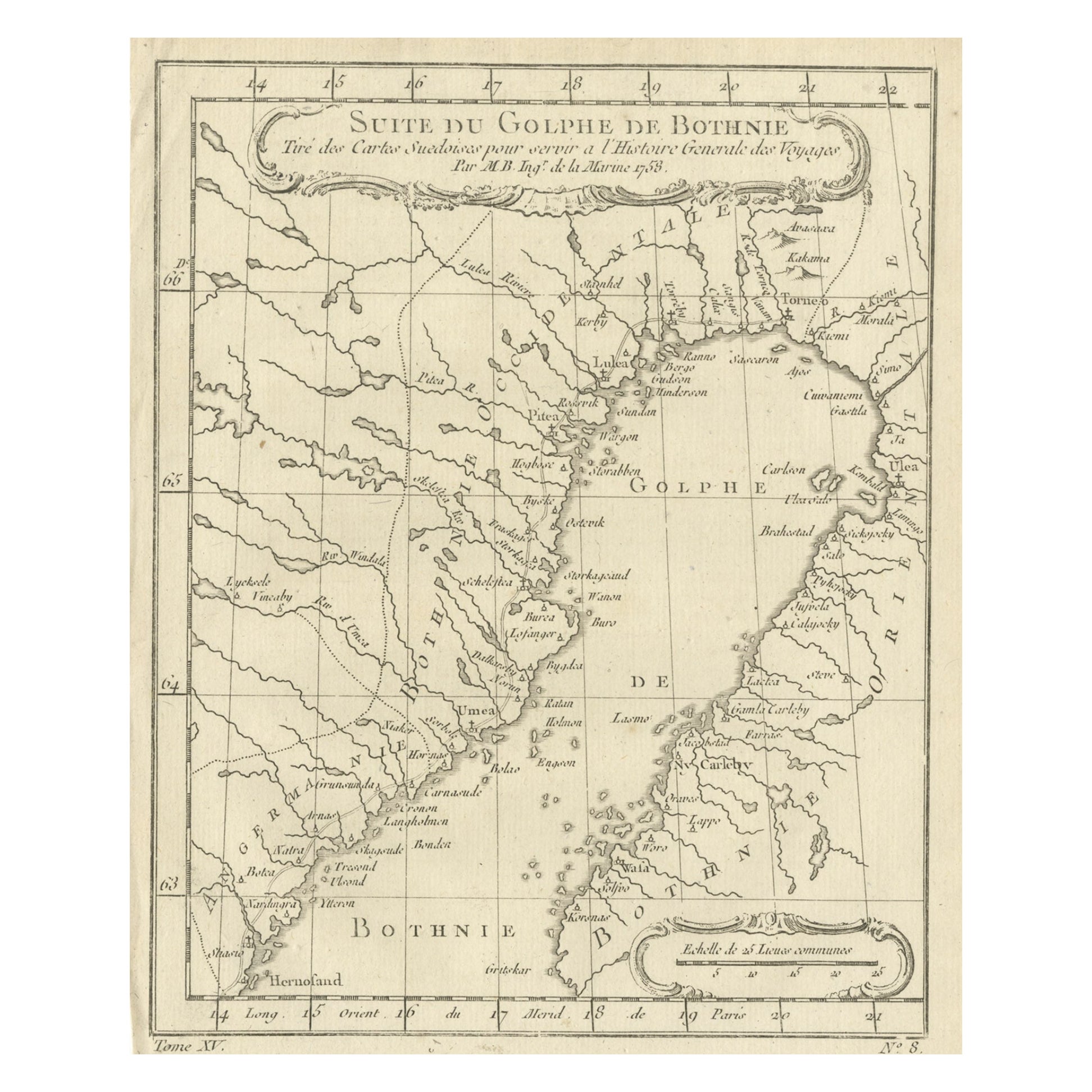
Antique map titled 'Suite du Golphe de Bothnie'.
Original antique map of the Gulf of Bothnia, the northernmost arm of the Baltic Sea. It is situated between Finland's west coast ...
Category
Antique 1750s Maps
Materials
Paper
$226 Sale Price
20% Off
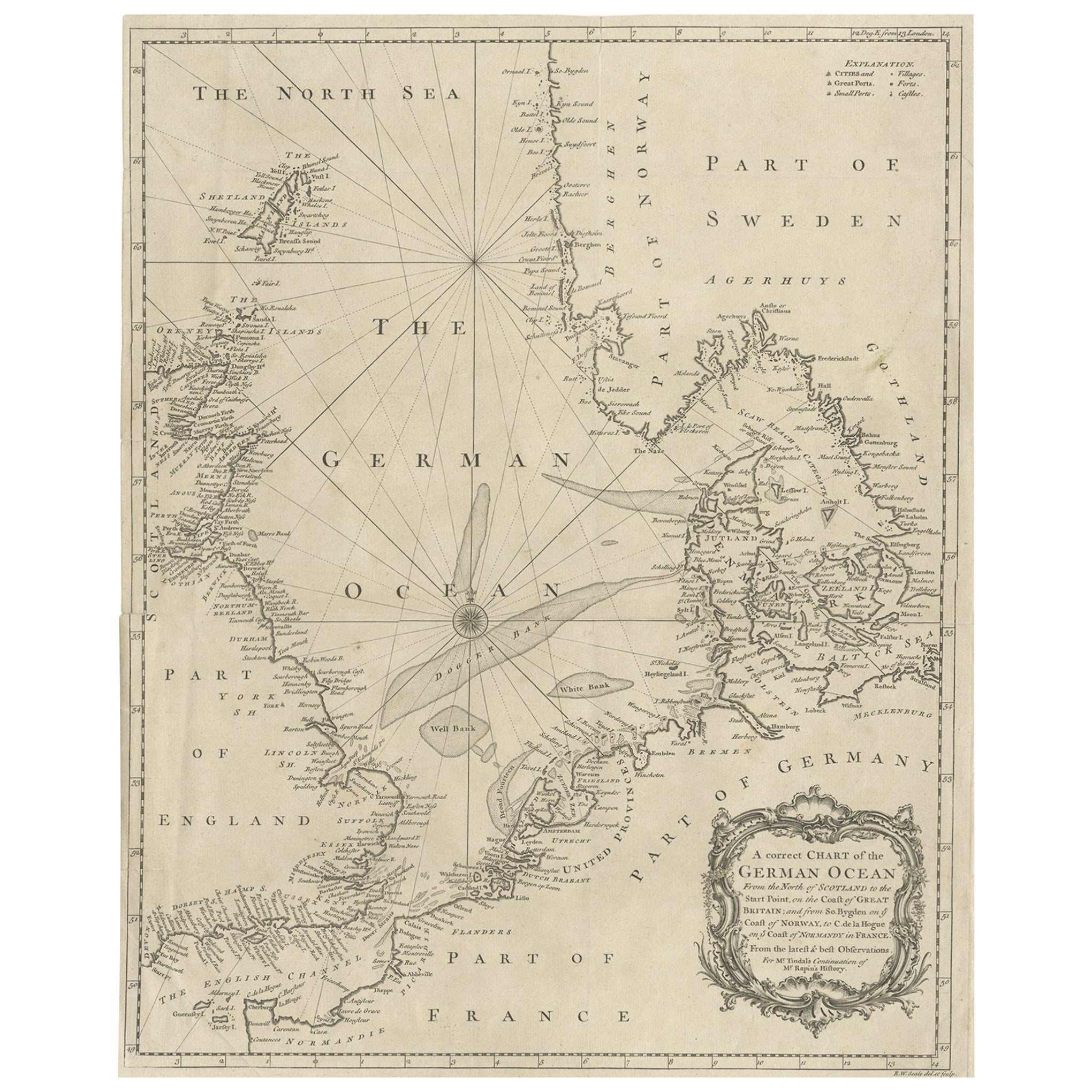
Antique Map of the North Sea From the English Channel to Norway & Sweden, 1746
Located in Langweer, NL
Antique map titled 'A correct Chart of the German Ocean from the North of Scotland to the Start Point, on the Coast of Great Britain; and from So. Bygden on ye coast of Norway, to C....
Category
Antique 1740s Maps
Materials
Paper

$463 Sale Price
20% Off
Antique Map of Scandinavia by T. Jefferys, circa 1750
Located in Langweer, NL
Antique map titled 'Sweden, Denmark, Norway & Finland'. An original mid-18th century copper engraved antique map of Scandinavia by Thomas Jefferys....
Category
Antique Mid-18th Century Maps
Materials
Paper

$179 Sale Price
20% Off
Antique Map of Denmark and Southern Sweden, c.1658
Located in Langweer, NL
Antique map titled 'Royaume de Danemarq.' Map centered on Sjaelland and covers all of Denmark and part of southern Sweden where a dramatic title cartouche obscures the interior. Sour...
Category
Antique 17th Century Maps
Materials
Paper

$255 Sale Price
20% Off
Denmark and Baltic Region – Antique Map by Guillaume de l’Isle, c.1730
By Covens & Mortier
Located in Langweer, NL
Denmark and Baltic Region – Antique Map by Guillaume de l’Isle, c.1730
This antique map titled Carte du Royaume de Danemark is a detailed 18th-century depiction of Denmark and its surrounding regions. Originally created by renowned French cartographer Guillaume de l’Isle, the map was published around 1730 by the Dutch publishers Covens...
Category
Antique Mid-18th Century Maps
Materials
Paper

$557 Sale Price
20% Off
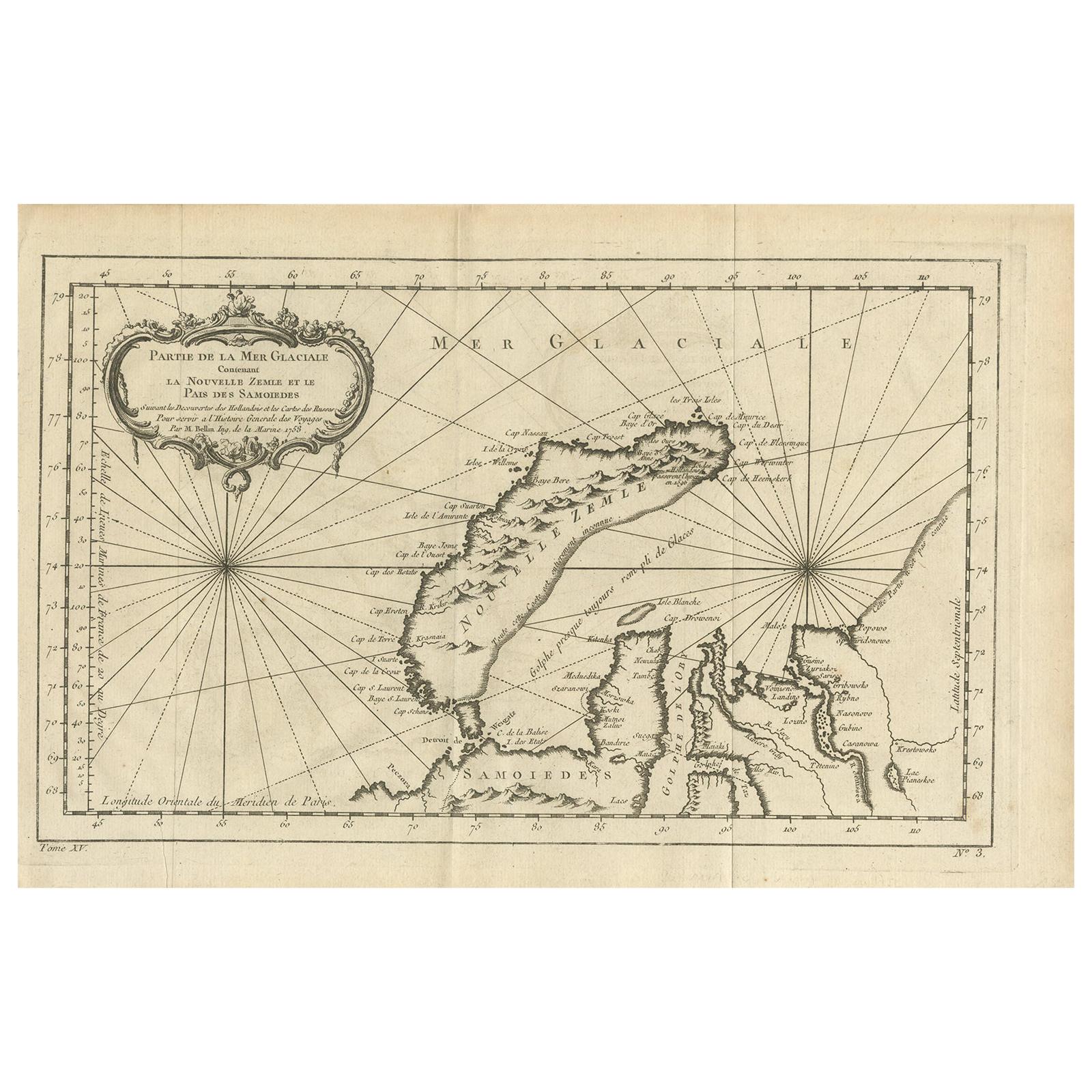
Antique Map of the Arctic Ocean and Novaya Zemlya by Bellin '1759'
Located in Langweer, NL
Antique map titled 'Partie de la Mer Glaciale contenant la Nouvelle Zemle et le Pais des Samoiedes (..)'. Original antique map of the Arctic Ocean containing Novaya Zemlya and the co...
Category
Antique Mid-18th Century Maps
Materials
Paper

$330 Sale Price
20% Off
You May Also Like
Original Antique Map of Sweden, Engraved by Barlow, 1806
Located in St Annes, Lancashire
Great map of Sweden
Copper-plate engraving by Barlow
Published by Brightly & Kinnersly, Bungay, Suffolk. 1806
Unframed.
Category
Antique Early 1800s English Maps
Materials
Paper

Hand-Colored 18th Century Homann Map of Denmark and Islands in the Baltic Sea
By Johann Baptist Homann
Located in Alamo, CA
An 18th century copper plate hand-colored map entitled "Insulae Danicae in Mari Balthico Sitae utpote Zeelandia, Fionia, Langelandia, Lalandia, Falstria, Fembria Mona" created by Joh...
Category
Antique Early 18th Century German Maps
Materials
Paper

17th Century Map of Denmark by French Cartographer Sanson, Dated 1658
By Nicolas Sanson
Located in Copenhagen, K
17th century map of Denmark by French cartographer Sanson.
Nicolas Sanson (20 December 1600-7 July 1667) was a French cartographer, termed by some the creator of French geography an...
Category
Antique 17th Century French Maps
Materials
Paper

1646 Jansson Map Entitled "Procinvia Connactiae, " Ric.a006
Located in Norton, MA
1646 Jansson map entitled
"Procinvia connactiae,"
Ric.a006
Description: The PROVINCE of CONNAVGT 490 x 380From vol 4 of Jansson's Atlas Novus 1646, published in Amsterdam with...
Category
Antique 17th Century Unknown Maps
Materials
Paper

Ancient Map-Poli Arctici (Map of the Poles)-Etching by Johannes Janssonius-1650s
By Johannes Janssonius
Located in Roma, IT
Poli Arctici is an ancient map realized in 1650 by Johannes Janssonius (1588-1664).
The Map is a Hand-colored etching, with coeval watercoloring.
Good conditions with slight foxing...
Category
1650s Modern Figurative Prints
Materials
Etching

Scandinavia & Portions of Eastern Europe: 18th Century Hand-Colored Homann Map
By Johann Baptist Homann
Located in Alamo, CA
An early 18th century hand-colored copper-plate map entitled "Regni Sueciae in omnes suas Subjacentes Provincias accurate divisi Tabula Generalis" by Johann Baptist Homann (1663-1724...
Category
Antique Early 18th Century German Maps
Materials
Paper

More Ways To Browse
Antique Maps Of Sicily
Antique Celestial Maps
Antique Compass Maritime Compasses
Bengal Map
J C Walker Map
Map Of Ancient Greece
Ptolemy Map
Antique Marine Compass
Map Of Jerusalem
1820 World Map
Cyprus Antique Maps
Antique Ecuador
Antique Map Of Thailand
Antique Mississippi Map
Antique Ohio Maps
Burgundy Map
John Speed Maps
Antique Map Of Turkish Empire