Items Similar to Original Antique Map of Juan Fernandez by Van Schley, 1757


Want more images or videos?
Request additional images or videos from the seller
1 of 6
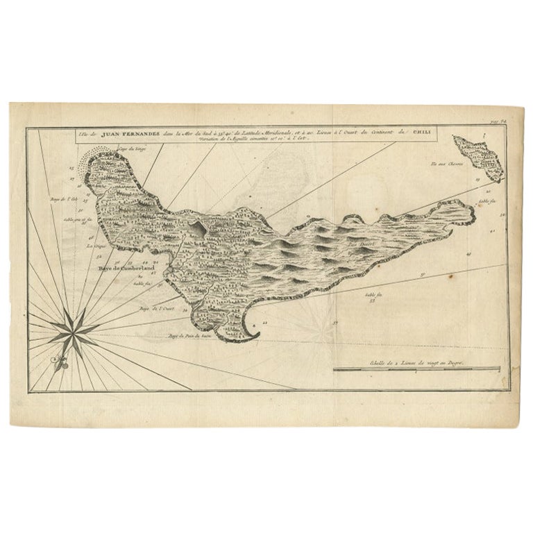
Original Antique Map of Juan Fernandez by Van Schley, 1757
$274
$342.5120% Off
£206.28
£257.8520% Off
€232
€29020% Off
CA$377.46
CA$471.8220% Off
A$422.73
A$528.4120% Off
CHF 220.57
CHF 275.7220% Off
MX$5,163.48
MX$6,454.3520% Off
NOK 2,806.35
NOK 3,507.9320% Off
SEK 2,645.32
SEK 3,306.6520% Off
DKK 1,766.02
DKK 2,207.5220% Off
About the Item
Antique map titled 'Carte Particuliere de l'Isle de Juan Fernandez - Byzondere Kaart van 't Eiland Juan Fernandez'.
Map of the Chilean Juan Fernandez Island, topped by a view of its rocky profile and adorned with a decorative title cartouche and a compass rose with fleur-de-lys. The map was based on Admiral George Anson's voyage in 1740, when he set sail in command of a squadron sent to attack Spanish possessions and interests in South America. The expedition was ill-equipped and failed to carry out its original ambitious mission. By June 1741 when Anson reached Juan Fernandes, his force had been reduced to only three of the original six ships, while the strength of his crews had fallen from 961 to 335. After launching several attacks on the west coast of South America and recuperating on the island, he collected the remaining survivors on his flagship, the Centurion, and set sail in search of one of the richly laden galleons that conducted the trade between Mexico and the Philippines. The indomitable perseverance he had shown during one of the most arduous voyages the history of sea adventure gained the reward of the capture of an immensely rich prize, the Nuestra Senora de Covadonga, which he encountered off Cape Espiritu Santo on June 20, 1743. Juan Fernandes Island was later made famous by Daniel Defoe's novel Robinson Crusoe as the island upon which he was marooned. This map originates from 'Histoire générale des voyages' by Antoine-François Prévost.
Artists and Engravers: Engraved by J. van Schley. Jakob van der Schley (Amsterdam, 1715-1779) was a Dutch draughtsman and engraver, who studied under Bernard Picart, and whose style he subsequently copied.
Condition: Good, given age. Some small damp stains in the lower margin. Left edge with a small tear. Small light crease bottom left corner. Original folds as issued. General age-related toning and/or occasional minor defects from handling. Please study image carefully.
Date: 1757.
- Dimensions:Height: 14.18 in (36 cm)Width: 9.97 in (25.3 cm)Depth: 0 in (0.01 mm)
- Materials and Techniques:
- Period:
- Date of Manufacture:1757
- Condition:Condition: Good, given age. Some small damp stains in the lower margin. Left edge with a small tear. Small light crease bottom left corner. Original folds as issued. General age-related toning and/or occasional minor defects from handling.
- Seller Location:Langweer, NL
- Reference Number:Seller: PCT-579081stDibs: LU3054326362392
About the Seller
5.0
Recognized Seller
These prestigious sellers are industry leaders and represent the highest echelon for item quality and design.
Platinum Seller
Premium sellers with a 4.7+ rating and 24-hour response times
Established in 2009
1stDibs seller since 2017
2,533 sales on 1stDibs
Typical response time: <1 hour
- ShippingRetrieving quote...Shipping from: Langweer, Netherlands
- Return Policy
Authenticity Guarantee
In the unlikely event there’s an issue with an item’s authenticity, contact us within 1 year for a full refund. DetailsMoney-Back Guarantee
If your item is not as described, is damaged in transit, or does not arrive, contact us within 7 days for a full refund. Details24-Hour Cancellation
You have a 24-hour grace period in which to reconsider your purchase, with no questions asked.Vetted Professional Sellers
Our world-class sellers must adhere to strict standards for service and quality, maintaining the integrity of our listings.Price-Match Guarantee
If you find that a seller listed the same item for a lower price elsewhere, we’ll match it.Trusted Global Delivery
Our best-in-class carrier network provides specialized shipping options worldwide, including custom delivery.More From This Seller
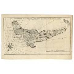
View AllAntique Map of the Coast of Juan Fernandez by Van Schley, 1757
Located in Langweer, NL
Antique map titled 'Cote du Nord Est de l'Isle de Juan Fernandez (..).' Map of the Chilean South Pacific archipelago of the Juan Fernandez Islands. This island was made famous by Dan...
Category
Antique 18th Century Maps
Materials
Paper

$135 Sale Price
20% Off
Antique Map of Juan Fernandez Island by Anson '1749'
Located in Langweer, NL
Antique map titled 'l'Ile de Juan Fernandes dans la Mer du Sud (..) - Het Eiland Juan Fernandes in de Zuid Zee (..)'. This map depicts Juan Fernandez Island in the Southern Sea. This...
Category
Antique Mid-18th Century Maps
Materials
Paper

$188 Sale Price
20% Off
Antique Map of Guadelupe in the Caribbean, 1759
By Jacques-Nicolas Bellin
Located in Langweer, NL
Antique map titled 'Carte De L'Isle De La Guadeloupe'. Detailed map of Guadalupe, Mari-Galante and the Isles de Saintes. Produced by Nichlas Bellin for Prevost d'Exiles influential t...
Category
Antique Mid-18th Century French Maps
Materials
Paper

Authentic Antique Map of the Caribbean, Gulf Coast and Central America, 1787
Located in Langweer, NL
Antique map titled 'Les Isles Antilles et le Golfe du Méxique'. Original old map of the Caribbean, Gulf Coast and Central America. With inset map of Bermuda...
Category
Antique Late 18th Century Maps
Materials
Paper

$292 Sale Price
20% Off
Free Shipping
Antique Map of Juan Fernandez Island by Anson, c.1740
Located in Langweer, NL
Antique map titled 'Plan de la Côte du N.E. de l 'Ile de Juan Fernandes'.
Map of the northeast coast of the island of Juan Fernandez with Cumberland Bay, South America. In 1740 Ans...
Category
Antique 18th Century Maps
Materials
Paper

$226 Sale Price
20% Off
Antique Map of Juan Fernandez, Chile, c.1740
Located in Langweer, NL
Antique map titled 'l'Ile de Juan Fernandes dans la Mer du Sud (..)'.
This map depicts Juan Fernandez Island in the Southern Sea. Source unknown, to be determined.
Artists and En...
Category
Antique 18th Century Maps
Materials
Paper
$179 Sale Price
20% Off
You May Also Like
Original Antique Map of South America. C.1780
Located in St Annes, Lancashire
Great map of South America
Copper-plate engraving
Published C.1780
Two small worm holes to left side of map
Unframed.
Category
Antique Early 1800s English Georgian Maps
Materials
Paper

1654 Joan Blaeu Map the Sutherland, Scotland, Entitled "Southerlandia, "Ric0007
Located in Norton, MA
1654 Joan Blaeu map of the
Sutherland, Scotland, entitled
"Southerlandia,"
Hand Colored
Ric0007
Description:
Lovely map centered on Sedan and D...
Category
Antique 17th Century Dutch Maps
Materials
Paper

Antique Map - Mare Pacificum - Etching by Johannes Janssonius - 1650s
By Johannes Janssonius
Located in Roma, IT
Mare Pacificum is an antique map realized in 1650 by Johannes Janssonius (1588-1664).
The Map is Hand-colored etching, with coeval watercolorang.
Good conditions with slight foxing...
Category
1650s Modern Figurative Prints
Materials
Etching

1705 Golfe de Mexico and Florida Framed Map
Located in Stamford, CT
Framed map of Mexico & Florida circa 1705, Paris. Small map with Mexico and the Gulf Coast. Inset text indicating Panama, Acapulco, Mexico City and the Mississippi. Extends North to ...
Category
Antique Early 1700s French Spanish Colonial Maps
Materials
Glass, Wood, Paper

Original Antique Map of Switzerland, Engraved By Barlow, Dated 1807
Located in St Annes, Lancashire
Great map of Switzerland
Copper-plate engraving by Barlow
Published by Brightly & Kinnersly, Bungay, Suffolk.
Dated 1807
Unframed.
Category
Antique Early 1800s English Maps
Materials
Paper

1627 Hendrik Hondius Map Entitled "Vltoniae Orientalis Pars, " Ric.a009
Located in Norton, MA
1627 Hendrik Hondius map entitled
"Vltoniae orientalis pars,"
Ric.a009
Title:
Vltoniae orientalis : pars
Title (alt.) :
Ultoniae orientalis pars
Creator:
Mercator, Gerh...
Category
Antique 17th Century Dutch Maps
Materials
Paper

More Ways To Browse
Mexican 18th Century Furniture
Mexican Santos
Spanish Santos
18th Century Santos
Ship Compass Antique
Small Antique Compass
Spanish Filipino
Galleon Ship
Cape Dutch Furniture
Philippines Map
Antique Map Of The Philippines
Spanish Galleon
Antique Furniture Centurion
Antique Map Chile
Nuestra Senora
Santos Philippines
T Robinson Furniture
Caribbean Colonial Furniture