Items Similar to Original Antique Sea Chart of the Northern Part of Hispaniola, Western Cuba

Want more images or videos?
Request additional images or videos from the seller
1 of 6
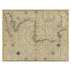
Original Antique Sea Chart of the Northern Part of Hispaniola, Western Cuba
$1,822.75
$2,278.4420% Off
£1,355.94
£1,694.9320% Off
€1,520
€1,90020% Off
CA$2,495.97
CA$3,119.9620% Off
A$2,775.18
A$3,468.9720% Off
CHF 1,449.05
CHF 1,811.3120% Off
MX$33,780.70
MX$42,225.8720% Off
NOK 18,489.19
NOK 23,111.4920% Off
SEK 17,323.49
SEK 21,654.3620% Off
DKK 11,570.92
DKK 14,463.6520% Off
Shipping
Retrieving quote...The 1stDibs Promise:
Authenticity Guarantee,
Money-Back Guarantee,
24-Hour Cancellation
About the Item
Antique map titled 'Pas kaart van de Noord Kust van Espaniola (..)'. Beautiful sea chart of the northern part of Hispaniola, western Cuba. The map includes the Turks & Caicos Islands and southern part of the Bahamas. Shows Guanahami or S. Salvador. Guanahani is an island in the Bahamas that was the first land in the New World sighted and visited by Christopher Columbus' first voyage, on October 12, 1492. It is not known precisely which island it was, and several theories have been put forth by historians. Guanahani is the native Taíno name; Columbus called it San Salvador. Originates from 'De Nieuwe Groote Lightende Zee-Fakkel'. Published by J. van Keulen, circa 1684.
The Van Keulens were a family of chartmakers and publishers. The firm, In de Gekroonde Lootsman (In the Crowned Pilot), was founded in 1678 by Johannes van Keulen (1654-1715). Van Keulen originally registered his business as a vendor of books and instruments (specifically cross-staffs). In 1680, however, he gained a privilege from the States of Holland and West Friesland for the publication of pilot guides and sea atlases.
In that year, van Keulen released his Zee-Atlas (Sea Atlas), which secured him a name in the competitive maritime publishing market. In 1681, he published the first volume of Nieuwe Lichtende Zee-Fakkel (New Shining Sea Torch). This would be the first of an eventual five volumes originally published between 1680 and 1684. A sixth volume was added in 1753. The Zee-Fakkel won van Keulen lasting fame. The atlas had charts compiled by Claes Jansz Vooght and artwork from Jan Luyken. It proved immensely popular and was reprinted until 1783. There were translations in French, English, Spanish, and Italian.
- Dimensions:Height: 21.26 in (54 cm)Width: 24.02 in (61 cm)Depth: 0.02 in (0.5 mm)
- Materials and Techniques:
- Period:Late 17th Century
- Date of Manufacture:circa 1684
- Condition:Additions or alterations made to the original: Top margin has been extended, repair on central vertical line. Both professional, and hardly visible. Wear consistent with age and use. General age-related toning. Later hand coloring, blank verso. Few small tears, mainly in bottom margin. Top margin has been extended, repair on central vertical line. Both professional, and hardly visible. Please study images carefully.
- Seller Location:Langweer, NL
- Reference Number:Seller: BG-132281stDibs: LU3054331099862
About the Seller
5.0
Recognized Seller
These prestigious sellers are industry leaders and represent the highest echelon for item quality and design.
Platinum Seller
Premium sellers with a 4.7+ rating and 24-hour response times
Established in 2009
1stDibs seller since 2017
2,511 sales on 1stDibs
Typical response time: <1 hour
- ShippingRetrieving quote...Shipping from: Langweer, Netherlands
- Return Policy
Authenticity Guarantee
In the unlikely event there’s an issue with an item’s authenticity, contact us within 1 year for a full refund. DetailsMoney-Back Guarantee
If your item is not as described, is damaged in transit, or does not arrive, contact us within 7 days for a full refund. Details24-Hour Cancellation
You have a 24-hour grace period in which to reconsider your purchase, with no questions asked.Vetted Professional Sellers
Our world-class sellers must adhere to strict standards for service and quality, maintaining the integrity of our listings.Price-Match Guarantee
If you find that a seller listed the same item for a lower price elsewhere, we’ll match it.Trusted Global Delivery
Our best-in-class carrier network provides specialized shipping options worldwide, including custom delivery.More From This Seller
View AllRare North Atlantic and Caribbean Sea Chart: Newfoundland to Venezuela, 1745
Located in Langweer, NL
This impressive map titled "Terra Neuf, en de Custen van Nieu Vranckryck, Nieuw Engeland... Venezuela," published by Louis Renard in 1745, captures the North Atlantic coastline, enco...
Category
Antique 1740s Maps
Materials
Paper
Sea Chart of Central America and the Northwest Coast of South America, ca.1745
Located in Langweer, NL
Antique map titled 'Novae Hispaniae, Chili, Peruviae et Guatamala Littorae.'
Sea chart of Central America and the northwest coast of South America, oriented to the east, by Reinier & Joshua Ottens (after Frederick de Wit - 1675) in 1745 ('Atlas van de Zeevaart'). The map shows all or parts of the coasts of Peru, Chili, Honduras, Costa Rica and Mexico as well as the western Caribbean and the Galapagos...
Category
Antique 1740s Maps
Materials
Paper
$2,350 Sale Price
20% Off
Free Shipping
Antique Sea Chart of North America by Ottens, circa 1745
Located in Langweer, NL
Antique map titled 'Septemtrionaliora Americae a Groenlandia (..)'. Sea chart of the northern waters of North America, including the coast of Labrador and pa...
Category
Antique Mid-18th Century Maps
Materials
Paper

Antique Sea Chart of the Western Coast of Africa
Located in Langweer, NL
Antique map titled 'Nieuwe Paskaert van de Kust van Genehoa (..)'. This attractive sea chart covers the western coast of Africa from Cape Blanco (Ras Nouadhibou) to Cape Verde (Dakar...
Category
Antique Late 17th Century Maps
Materials
Paper
$853 Sale Price
20% Off
Original Antique Sea Chart of the Coastline from England to Gibraltar, ca.1700
Located in Langweer, NL
Antique map titled 'A Chart of the Sea-Coast from England to the Streights.'
Original antique map showing the European coastline from the South of England (and North of France) to ...
Category
Antique Early 1700s Maps
Materials
Paper
$911 Sale Price
20% Off
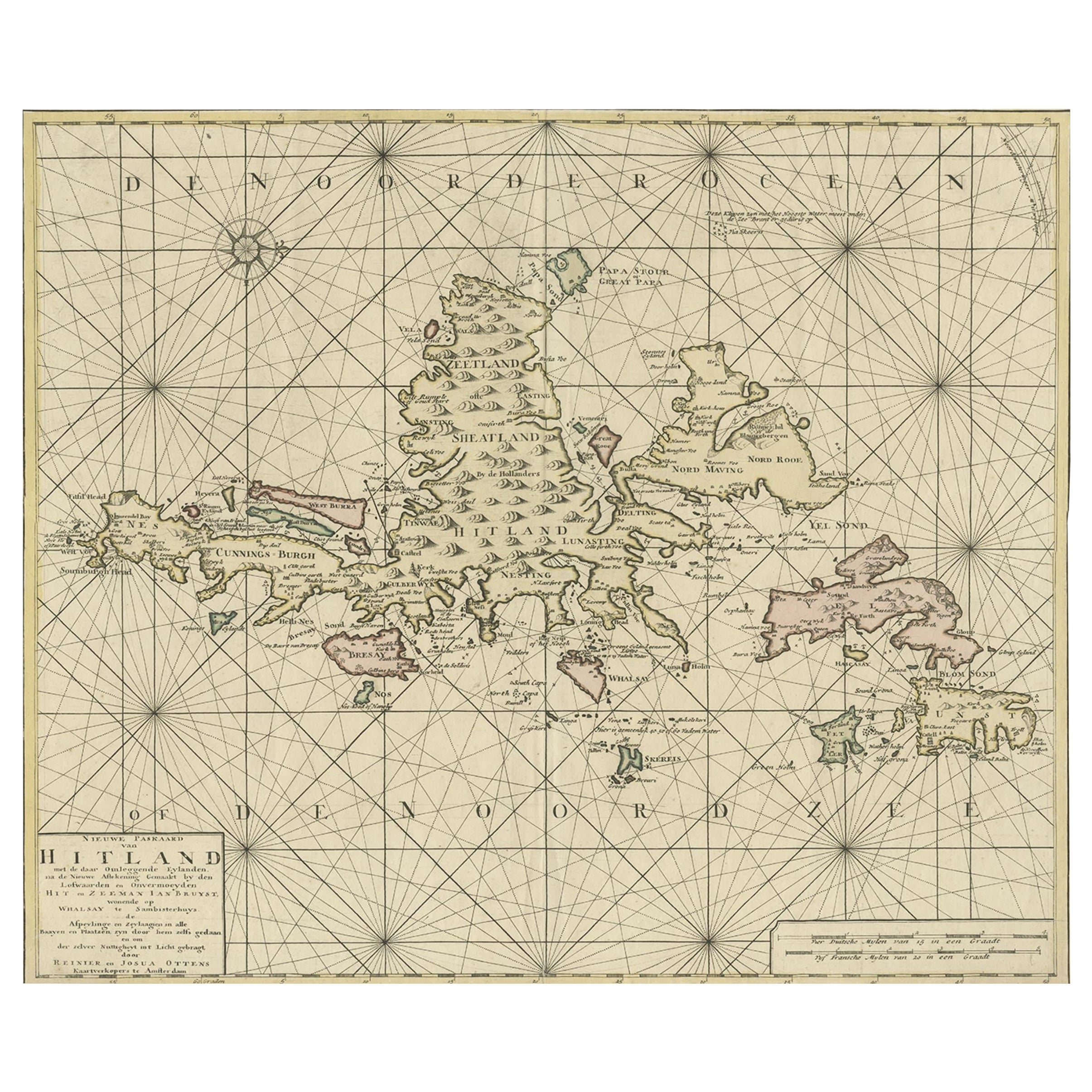
Shetland Islands Sea Chart – Antique Nautical Map by Ottens Brother c.1745
Located in Langweer, NL
Shetland Islands Sea Chart – Antique Nautical Map by Ottens Brothers, c.1740s
This striking antique nautical chart titled Nieuwe Paskaard van Hitland… presents the Shetland Islands ...
Category
Antique 1740s Dutch Maps
Materials
Paper
$1,199 Sale Price
20% Off
You May Also Like
Plymouth, England: A Hand-Colored 17th Century Sea Chart by Captain Collins
By Captain Greenvile Collins
Located in Alamo, CA
This hand-colored sea chart of the area around Plymouth, England from "Great Britain's Coasting Pilot. Being a New and Exact Survey of the Sea-Coast of England", first published in 1...
Category
Antique Late 17th Century English Maps
Materials
Paper

19th Century Nautical Chart of Martinique
Located in Norwell, MA
Original map of Martinique from 1887 with chartered waters around the island. Prepared from a French survey, completed in 1825, showing town, ports, rivers and tributaries. Published...
Category
Antique 19th Century Nautical Objects

Early 19th Century Hand Colored Map of the United States and Caribbean Islands
Located in Hamilton, Ontario
Hand coloured early 19th century map by Giraldon of France titled "Etats Unis et Grandes Antilles" (United States and Greater Antilles).
Category
Antique Early 19th Century French Maps
Materials
Paper

$595 Sale Price
40% Off
West Coast of Africa, Guinea & Sierra Leone: An 18th Century Map by Bellin
By Jacques-Nicolas Bellin
Located in Alamo, CA
Jacques Bellin's copper-plate map entitled "Partie de la Coste de Guinee Dupuis la Riviere de Sierra Leona Jusquau Cap das Palmas", depicting the coast of Guinea and Sierra Leone in ...
Category
Antique Mid-18th Century French Maps
Materials
Paper

California, Alaska and Mexico: 18th Century Hand-Colored Map by de Vaugondy
By Didier Robert de Vaugondy
Located in Alamo, CA
This is an 18th century hand-colored map of the western portions of North America entitled "Carte de la Californie et des Pays Nord-Ouest separés de l'Asie par le détroit d'Anian, ex...
Category
Antique 1770s French Maps
Materials
Paper

Antique Map of the Southern Oceans, South America and Africa
Located in New York, NY
Antique Map of the South Atlantic, c. 1800s
Engraving
20 x 28 in.
Framed: 25 3/4 x 33 3/4 in.
Category
19th Century Realist Figurative Prints
Materials
Engraving
More Ways To Browse
Antique Curiosities Artwork
Maritime Antiques
Bahamas Furniture
Used Furniture Bahamas
Cuban Antiques
Jan Luyken
Patagonia Map
Shepherd And Hedger
Vignola Furniture
Washington Dc Map
Antique Map Of Cornwall
Coronelli Globe
Vintage Bartholomew Maps
Antique Alabama Map
Cape Cod Map
Goa France
Antique Planisphere
Charlotte Reine