Items Similar to Original Antique Sea Chart of the Coastline from England to Gibraltar, ca.1700

Want more images or videos?
Request additional images or videos from the seller
1 of 6
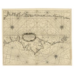
Original Antique Sea Chart of the Coastline from England to Gibraltar, ca.1700
About the Item
Antique map titled 'A Chart of the Sea-Coast from England to the Streights.'
Original antique map showing the European coastline from the South of England (and North of France) to the Strait of Gibraltar and the northern coast of Africa. Soundings are indicated in the Channel, Strait and along the Spanish and Portugese coasts. Rocks, islands, etc. are also indicated.
Artists and Engravers: Published by Mount & Page, London.
Condition: Good, given age. Original middle fold, as issued. Left and right margins cropped close to the image area (right with very slight loss of image). Both margins extended with contemporary paper (backed with acid-free archival tape on the rear) for framing purposes. A crease beside the middle fold, from the top into the image. A few small tears in the margin edges. A small closed tear in the right edge of the image, just above the punched library stamp (Brooklyn Public Library; backed with contemporary paper). General age-related toning and/or occasional minor defects from handling. Please study image carefully.
- Dimensions:Height: 18.47 in (46.9 cm)Width: 23.55 in (59.8 cm)Depth: 0 in (0.02 mm)
- Materials and Techniques:
- Period:1700-1709
- Date of Manufacture:circa 1700
- Condition:Repaired: Both margins extended with contemporary paper (backed with acid-free archival tape on the rear) for framing purposes. Wear consistent with age and use. Original middle fold, as issued. Left and right margins cropped close to the image area (right with very slight loss of image). Both margins extended with contemporary paper (backed with acid-free archival tape on the rear) for framing purposes.
- Seller Location:Langweer, NL
- Reference Number:Seller: PCT-567961stDibs: LU3054326767842
About the Seller
5.0
Platinum Seller
These expertly vetted sellers are 1stDibs' most experienced sellers and are rated highest by our customers.
Established in 2009
1stDibs seller since 2017
1,922 sales on 1stDibs
Typical response time: <1 hour
- ShippingRetrieving quote...Ships From: Langweer, Netherlands
- Return PolicyA return for this item may be initiated within 14 days of delivery.
Auctions on 1stDibs
Our timed auctions are an opportunity to bid on extraordinary design. We do not charge a Buyer's Premium and shipping is facilitated by 1stDibs and/or the seller. Plus, all auction purchases are covered by our comprehensive Buyer Protection. Learn More
More From This SellerView All
- Antique Chart of The Spanish Coastline from Bilbao Eastwards, C.1720Located in Langweer, NLAntique map titled 'A Chart of the Sea Coasts Biscay and Gallicia Between Cape Machicaca and Cape de Pinas and from Cape de Pinas to Cape de Finisterre.' Map of the Spanish coastline...Category
Antique 18th Century Maps
MaterialsPaper
- Antique Sea Chart of the Shetland Islands, Scotland, ca.1745Located in Langweer, NLAntique map of Scotland titled 'Nieuwe Paskaard van Hitland met de daar omleggende eylanden na de nieuwe aftekening gemaakt by den Lofwaarden en onvermoeyden Hit en Zeeman Ian Bruyst...Category
Antique 1740s Maps
MaterialsPaper
- Original Antique Sea Chart of the Northern Part of Hispaniola, Western CubaLocated in Langweer, NLAntique map titled 'Pas kaart van de Noord Kust van Espaniola (..)'. Beautiful sea chart of the northern part of Hispaniola, western Cuba. The map includes the Turks & Caicos Islands and southern part of the Bahamas. Shows Guanahami or S. Salvador. Guanahani is an island in the Bahamas that was the first land in the New World sighted and visited by Christopher Columbus' first voyage, on October 12, 1492. It is not known precisely which island it was, and several theories have been put forth by historians. Guanahani is the native Taíno name; Columbus called it San Salvador. Originates from 'De Nieuwe Groote Lightende Zee-Fakkel'. Published by J. van Keulen, circa 1684. The Van Keulens were a family of chartmakers and publishers. The firm, In de Gekroonde Lootsman (In the Crowned Pilot), was founded in 1678 by Johannes van Keulen (1654-1715). Van Keulen originally registered his business as a vendor of books and instruments (specifically cross-staffs). In 1680, however, he gained a privilege from the States of Holland and West Friesland for the publication of pilot guides and sea atlases. In that year, van Keulen released his Zee-Atlas (Sea Atlas), which secured him a name in the competitive maritime publishing market. In 1681, he published the first volume of Nieuwe Lichtende Zee-Fakkel (New Shining Sea Torch). This would be the first of an eventual five volumes originally published between 1680 and 1684. A sixth volume was added in 1753. The Zee-Fakkel won van Keulen lasting fame. The atlas had charts compiled by Claes Jansz Vooght and artwork from Jan Luyken...Category
Antique Late 17th Century Maps
MaterialsPaper
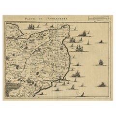
- Uncommon Antique Map of the English Channel Coastline, ca.1709Located in Langweer, NLAntique map titled 'Partie de L'Angleterre' Uncommon map of the English Channel coastline with many boats on the sea. Source unknown, to be determined. Artists and Engravers: Made...Category
Antique Early 1700s Maps
MaterialsPaper
- Attractive Original Map of the Province of Overijssel, the Netherlands, Ca.1700Located in Langweer, NLAntique print, titled: 'Transisalania Provincia vulgo Over-yssel.' Attractive original handcoloured map of the province of Overijssel, The Netherlands. With beautiful title carto...Category
Antique Early 1700s Maps
MaterialsPaper
- Curious Map of the Laptev Sea 'Arctic Ocean' and the Mediterranean, ca.1700Located in Langweer, NLAntique map, untitled. Map of the Laptev Sea (Arctic Ocean) and the Mediterranean, printed for Scherer's 'Atlas Novus' (1702-1710). Scherer's 'Atlas Novus' forms an important mil...Category
Antique Early 1700s Maps
MaterialsPaper

You May Also Like
- Antique Anatomical Wall Chart Depicting the Human SkeletonLocated in Berghuelen, DEA rare 19th century anatomical wall chart depicting the human skeleton. On the sides On the sides are detailed description in German language. The wall...Category
Early 20th Century German Victorian Prints
MaterialsPaper
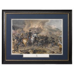
- "On the March to the Sea" Print by Alexander Hay Ritchie, after F.O.C DarleyBy Alexander Hay RitchieLocated in Colorado Springs, COThis color print of On The March to the Sea by Felix O.C. Darley, and engraved by A.H. Ritchie, is a stunning portrayal of William T. Sherman’s notorious Georgia Campaign. Originally...Category
Antique 1860s American Prints
MaterialsPaper
- Antique Foldable Anatomical Wall Chart Depicting Human MusculatureLocated in Berghuelen, DEAntique Foldable Anatomical Wall Chart Depicting Human Musculature The rare 19th century anatomical wall chart depicts the human musculature and inter...Category
Early 20th Century German Victorian Prints
MaterialsWood, Paper
- Alpine Ski Photograph, 'THE JUMP' Taken from 1930s OriginalLocated in Oxfordshire, GBVintage, Alpine Ski photograph. 'THE JUMP', a new mounted black and white photographic image after an original 1930s skiing photograph. Prior to being a recreational activity skiing was purely a means of travelling from A to B through the snow, it only started to become the sport it is today in the mid-1800s. The price displayed is for the mounted photo only. Image size 25.5cm x 40cm = 10 X 15 ½" ". The alpine photograph...Category
Vintage 1930s English Sporting Art Sports Equipment and Memorabilia
MaterialsPaper
- “A Football Match, Scotland v. England” Antique Engraving, Proof Edition of 100By Overend and SmytheLocated in Colorado Springs, COThis is the 1889 William H. Overend (1851-1898) and Lionel Smythe (1839-1918) first edition, photogravure of the Calcutta Cup – a Rugby match between Scotland and England, that has been played over 100 times, the first match...Category
Antique 19th Century English Prints
MaterialsPaper
- Old Horizontal Map of EnglandBy TassoLocated in Alessandria, PiemonteST/520 - Old rare Italian map of England, dated 1826-1827 - by Girolamo Tasso, editor in Venise, for the atlas of M.r Le-Sage.Category
Antique Early 19th Century Italian Other Prints
MaterialsPaper