Early 1800s Maps
to
84
98
98
4
1
2,976
2,230
476
3
290
34
10
126
9
37
9
2
5
4
3
3
98
1
13
6
6
4
1
98
98
98
1
Period: Early 1800s
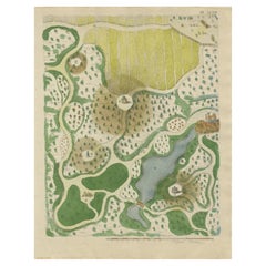
18th-Century Dutch Garden Design by Gijsbert van Laar, Published in 1802
Located in Langweer, NL
18th-Century Dutch Garden Design by Gijsbert van Laar – Magazijn van tuin-sieraaden, 1802
This exquisite hand-colored engraving is from the renowned work 'Magazijn van tuin-sieraa...
Category
Antique Early 1800s Maps
Materials
Paper
$130 Sale Price
20% Off
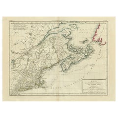
Antique Map of the Northeastern United States and Canada by Tardieu, 1802
Located in Langweer, NL
This antique map titled "Carte de la Partie Septentrionale des Etats Unis," created by Pierre Antoine Tardieu, depicts the northeastern part of the United States and parts of Canada....
Category
Antique Early 1800s Maps
Materials
Paper
$522 Sale Price
20% Off
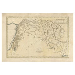
Antique 19th Century Map of Ancient Syria & Assyria - Historical Regions, c.1802
Located in Langweer, NL
19th Century Map of Ancient Syria and Assyria: 'Tabula Regiones inter Syriam et Assyriam continens'"*
This beautifully detailed 18th-century map, titled...
Category
Antique Early 1800s Maps
Materials
Paper
$288 Sale Price
20% Off
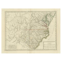
Antique Map of South Carolina, North Carolina, and Virginia by Tardieu, 1802
Located in Langweer, NL
This is an original antique map titled "Carte de la Caroline Méridionale et Septentrionale et de la Virginie," depicting the regions of South Carolina, North Carolina, and Virginia in the early 19th century. Created by Pierre Antoine Tardieu, this map provides a detailed view of the geographical and political landscape of these southeastern United States areas.
Map Details:
- **Title**: Carte de la Caroline Méridionale et Septentrionale et de la Virginie
- **Creator**: Pierre Antoine Tardieu (1784-1869)
- **Publication Date**: Early 19th century
- **Dimensions**: Approximately 34.5 x 43.5 cm (13.5 x 17.25 inches)
- **Features**: The map includes detailed representations of South Carolina, North Carolina, and Virginia, highlighting political boundaries, major cities, rivers, and other geographical features. The title cartouche is located in the lower right corner, and the outlines are hand-colored to distinguish different regions.
Key Geographic Features and Areas:
1. **South Carolina**:
- Major cities such as Charleston and Columbia are marked.
- The map details the rivers and topography, including the Savannah River and various inland features.
2. **North Carolina**:
- Key locations such as Raleigh and New Bern...
Category
Antique Early 1800s Maps
Materials
Paper
$522 Sale Price
20% Off
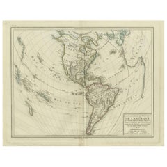
Antique Map of North and South America by Pierre Antoine Tardieu (1784-1869)
Located in Langweer, NL
This is an original antique map titled "Carte Générale et Politique de l'Amérique," depicting the political and geographical features of North and South America. This map, created by Pierre Antoine Tardieu, illustrates the continent's boundaries, major regions, and significant features as understood in the early 19th century.
Map Details:
- **Title**: Carte Générale et Politique de l'Amérique
- **Creator**: Pierre Antoine Tardieu (1784-1869)
- **Publication Date**: Early 19th century
- **Dimensions**: Approximately 34.5 x 43.5 cm (13.5 x 17.25 inches)
- **Features**: The map includes detailed representations of North and South America, highlighting political boundaries, major cities, rivers, and mountain ranges. The title cartouche is located in the lower right corner, and the outlines are hand-colored to distinguish different regions and countries.
Condition Overview:
1. Paper Quality: The paper shows typical signs of aging, such as slight yellowing, but remains in good condition without major tears or damage.
2. Edges and Corners: The edges are slightly worn, with minor fraying and small tears, particularly near the center fold. These imperfections do not significantly impact the overall readability or aesthetic value.
3. Center Fold: A center fold is present, which is common for maps of this period that were often folded for storage or publication. The fold appears intact without significant separation or damage, except for a small split at the lower end.
4. Color and Print Quality: The hand-colored outlines remain vibrant and clear, highlighting the borders of different regions. The print quality is excellent, with sharp, legible text and detailed illustrations.
5. Staining and Spots: There are a few spots and stains, particularly near the edges and along the fold. These do not obscure any critical details of the map.
Historical Context
Around the year 1800, the Americas were a region of significant political change and exploration. Here’s an overview of the region during that period:
Political Landscape
1. North America:
- United States: The United States was a young nation, having gained independence from Great Britain in 1776. The early 19th century was a period of westward expansion and the establishment of new states.
- Canada: Canada was divided into British colonies, including Upper Canada (Ontario) and Lower Canada (Quebec). The British maintained control over these territories following the American Revolution.
- Mexico: Mexico was part of the Spanish Empire, known as New Spain. It would gain independence from Spain in 1821.
2. Central and South America:
- Spanish Colonies: Much of Central and South America was under Spanish colonial rule. Significant regions included New Granada (Colombia), Peru, and the Viceroyalty of the Rio de la Plata (Argentina).
- Portuguese Brazil: Brazil was a Portuguese colony and the largest territory in South America. It would gain independence from Portugal in 1822.
- Independence Movements: The early 19th century was marked by independence movements across Latin America, led by figures such as Simón Bolívar and José de San Martín, which resulted in the creation of new nations.
3. Caribbean:
- The Caribbean islands were controlled by various European powers, including Spain, France, Great Britain, and the Netherlands. These islands were significant for their sugar plantations and as hubs of the Atlantic slave trade.
Socio-Economic Conditions
1. Trade and Commerce:
- The Americas were integral to global trade, exporting commodities such as sugar, tobacco, cotton, and coffee. The port cities of Havana, Veracruz, and Buenos Aires were crucial trade...
Category
Antique Early 1800s Maps
Materials
Paper
$484 Sale Price
20% Off
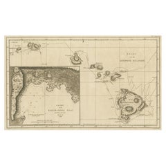
Map of the Hawaiian Islands with a Large Inset of Karakakooa Bay, 1803
Located in Langweer, NL
Antique map titled 'Kaart van de Sandwich Eilanden'.
Map of the Hawaiian Islands with a large inset of Karakakooa Bay, including soundings and anchorages. Originates from 'Reizen R...
Category
Antique Early 1800s Maps
Materials
Paper
$2,097 Sale Price
20% Off
Map of Italy and Neighboring Regions by Delamarche – Antique Map, c.1800
Located in Langweer, NL
Antique Map of Italy and Surrounding Regions by Delamarche, circa 1800
This elegant and detailed antique map titled Carte Générale de l’Italie was drawn and engraved by the French g...
Category
French Antique Early 1800s Maps
Materials
Paper
Political Map of Europe: Early 19th Century, from the 1802 Tardieu Atlas
Located in Langweer, NL
Antique Map Description
Title: Carte Générale et Politique de l'Europe
Publication Details:
- **Atlas Title:** Nouvel Atlas Universel de Géographie Ancienne et Moderne
- **Purpose...
Category
Antique Early 1800s Maps
Materials
Paper
$447 Sale Price
20% Off
Ptolemaic Armillary Sphere Charles-François Delamarche Paris, 1805-1810 Circa
Located in Milano, IT
Charles-François Delamarche
Ptolemaic armillary sphere
Paris, circa 1805-1810
Wood and papier-mâché
covered with printed and partly hand-coloured paper
It measures 15.74” in height, ...
Category
French Empire Antique Early 1800s Maps
Materials
Paper, Wood
1806 John Cary Map of Hindoostan – Detailed British Cartography of India
Located in Langweer, NL
Title: 1806 John Cary Map of Hindoostan – Detailed British Cartography of India
This highly detailed map, titled "A New Map of Hindoostan from the Latest Authorities," was engraved ...
Category
Antique Early 1800s Maps
Materials
Paper
$503 Sale Price
20% Off
1808 C. Smith Map of Hindoostan – British India with Intricate Details
Located in Langweer, NL
Title: 1808 C. Smith Map of Hindoostan – British India with Intricate Details
This map, titled "Hindoostan," was published by C. Smith, a prominent London map seller, on January 6, ...
Category
Antique Early 1800s Maps
Materials
Paper
$363 Sale Price
20% Off
Old Print of a Countrywoman of Upper Carniola, Slovenia, Eastern Europe, 1804
Located in Langweer, NL
Old print of a countrywoman of Upper Carniola, Slovenia.
This print originates from 'The Costume of the Hereditary States of the House of Austria' by William Miller.
Artists and engravers: Engraved by William Ellis.
Category
Antique Early 1800s Maps
Materials
Paper
$261 Sale Price
20% Off
Map of Ancient Gaul & Roman Provinces: Early 19th Century - 1802 Tardieu Atlas
Located in Langweer, NL
### Antique Map Description
**Title:** La Gaule et Ses Grandes Dignités Romaines au Temps des Empereurs
**Publication Details:**
- **Atlas Title:** Nouvel Atlas Universel de Géogra...
Category
Antique Early 1800s Maps
Materials
Paper
1802 Map of Australasia and the South Pacific - European Exploration Routes
Located in Langweer, NL
1802 Johann Walch Map of Australasia and the South Pacific - European Exploration Routes
This 1802 map by Johann Walch provides a highly detailed view of Australasia and the South P...
Category
Antique Early 1800s Maps
Materials
Paper
$1,677 Sale Price
20% Off
Antique Map of Jamaica and Hispaniola (Saint-Domingue and Santo Domingo), 1802
Located in Langweer, NL
This is an original antique map titled "Carte des Isles de la Jamaïque et de St. Domingue," depicting the islands of Jamaica and Saint-Domingue (modern-day Haiti and the Dominican Re...
Category
Antique Early 1800s Maps
Materials
Paper
$522 Sale Price
20% Off
Antique Map of the Gulf of Mexico and Caribbean Islands by Tardieu, 1802
Located in Langweer, NL
This is an original antique map titled "Carte du Golfe du Mexique et des Isles Antilles," depicting the Gulf of Mexico and the Caribbean islands. Created by Pierre Antoine Tardieu, t...
Category
Antique Early 1800s Maps
Materials
Paper
$522 Sale Price
20% Off
Antique Map of the Island of Tahiti, Polynesia, 1803
Located in Langweer, NL
Antique map Tahiti titled 'Kaart van het Eiland Otahiti'.
Antique map of the Island of Tahiti, Polynesia. Originates from 'Reizen Rondom de Waereld door James Cook (..)'.
Artists...
Category
Dutch Antique Early 1800s Maps
Materials
Paper
Original Antique Map of Dresden, Germany by J. Stockdale, 1800
Located in Langweer, NL
Vintage Map of Dresden, Germany by J. Stockdale, 1800
This vintage map titled "A Plan of the City of Dresden" was published by J. Stockdale in Piccadilly, London, in 1800. It provid...
Category
Antique Early 1800s Maps
Materials
Paper
Original Hand-Colored Antique Costume Print of a Peasant from Hungary, 1804
Located in Langweer, NL
Old print of a Hungarian peasant. This print originates from 'The Costume of the Hereditary States of the House of Austria' by William Miller.
Artists and Engravers: Engraved by William Ellis.
Category
Antique Early 1800s Maps
Materials
Paper
$261 Sale Price
20% Off
World Map in Two Hemispheres: Eastern & Western - 1802 Tardieu Atlas
Located in Langweer, NL
Antique Map with Title: "Mappemonde en Deux Hémisphères"
Publication Details:
- **Atlas Title:** Nouvel Atlas Universel de Géographie Ancienne et Moderne
- **Purpose:** For the Nouvelle Edition de la Géographie de Guthrie
- **Mapmakers:** P. F. Tardieu, with contributions from various geographical works
- **Publisher:** Chez Hyacinthe Langlois, Libraire, quai des Augustins, n° 45
- **Year:** An X - 1802 (French Revolutionary Calendar)
**Geographical Scope:**
This antique map illustrates a double-hemisphere world map, showing both the Eastern (Old World) and Western (New World) hemispheres. It provides a global perspective, capturing the entire known world as understood in the early 19th century.
**Map Features:**
- **Hemispheres Displayed:**
- **Western Hemisphere:** The Americas, labeled as "Hémisphère Occidental ou Nouveau Monde...
Category
Antique Early 1800s Maps
Materials
Paper
$428 Sale Price
20% Off
Antique Map of the Dusky Bay or Dusky Sound of New Zealand by Captain Cook, 1803
Located in Langweer, NL
Antique map New Zealand titled 'Schets van de Donkere Baai in Nieuw Zeeland 1773'.
Antique map of the Dusky Bay/Dusky Sound of New Zealand....
Category
Antique Early 1800s Maps
Materials
Paper
$549 Sale Price / item
20% Off
Antique Print of Oedidee, a Native from Bora Bora, 1803
Located in Langweer, NL
Antique print titled 'Oedidee Jongman van Bolabola'.
Antique print of Oedidee, a native from Bora Bora. Originates from 'Reizen Rondom de Waereld door James Cook (..)'.
Artis...
Category
Antique Early 1800s Maps
Materials
Paper
$167 Sale Price
20% Off
De Natsche – Ceremony for the King's Son, Tonga c.1795
Located in Langweer, NL
De Natsche – Ceremony for the King's Son, Tonga c.1795
This antique print depicts a grand ceremony held in honour of the son of the King of Tonga, known as the Natsche, in the villa...
Category
European Antique Early 1800s Maps
Materials
Paper
$549 Sale Price
20% Off
Antique Map of Egypt with Detailed Inset of the Nile Delta, ca. 1799
Located in Langweer, NL
Antique Map of Egypt with Detailed Inset of the Nile Delta, ca. 1799
This finely engraved antique map titled Carte Physique et Politique de l’Égypte presents a detailed and scientif...
Category
French Antique Early 1800s Maps
Materials
Paper
Decorative Antique Map of Sweden and Part of Finland, 1806
Located in Langweer, NL
Antique map titled 'La Suede.'
Decorative map of Sweden and part of Finland by Robert de Vaugondy, revised and published by Delamarche. Source unknown, to be determined.
Artists and Engravers: Made by 'Charles Francois Delamarche' after an anonymous artist. Charles Francois Delamarche (1740-1817) founded the important and prolific Paris based Maison Delamarche map publishing firm in the late 18th century. A lawyer by trade Delamarche entered the map business with the acquisition from Jean-Baptiste Fortin of Robert de Vaugondy's map plates...
Category
French Antique Early 1800s Maps
Materials
Paper
Early Map of Sydney with Botany Bay, Port Jackson & Broken Bay, Australia, 1802
Located in Langweer, NL
Interesting chart of the three harbours of Botany Bay, Port Jackson, and Broken Bay showing the ground cultivated by the colonists. In the early days of the settlement in Australia t...
Category
Antique Early 1800s Maps
Materials
Paper
$1,053 Sale Price
20% Off
Original 1806 Engraved Map of Asia and Surrounding Regions by John Cary
Located in Langweer, NL
The map titled "A New Map of Asia, From the Latest Authorities" was published in 1806. It is a detailed and comprehensive depiction of the continent of Asia, extending from Europe and the Arabian Peninsula in the west to Japan and the Pacific Islands in the east, and from the Arctic regions in the north to parts of New Holland (Australia) and the Indian Ocean in the south.
The map is finely engraved, with political boundaries delineated using color to distinguish different empires, kingdoms, and colonial possessions of the time. Key geographical features such as mountain ranges, rivers, and major cities are clearly marked. It also includes significant maritime routes and islands across the Indian and Pacific Oceans, reflecting the global trade and exploration activities of the early 19th century.
Notable Features:
- Asia is represented with its vast and diverse regions, including the extensive Russian Empire in the north, the Ottoman Empire in the west, the Qing Dynasty's control over China, and the Mughal Empire's influence in India, which is under increasing British control.
- India is shown with its numerous princely states, many of which are under British influence or control.
- Southeast Asia includes the colonial possessions of European powers, particularly the Dutch East Indies, Spanish Philippines...
Category
Antique Early 1800s Maps
Materials
Paper
$736 Sale Price
20% Off
Old Print of a Peasant of Hermannstadt 'Sibiu', Transylvania, 1804
Located in Langweer, NL
Old print of a peasant of the neighbourhood of Hermannstadt (Sibiu), Transylvania.
This print originates from 'The Costume of the Hereditary States of the House of Austria' by William Miller.
Artists and Engravers: Engraved by William Ellis.
Category
Antique Early 1800s Maps
Materials
Paper
$242 Sale Price
20% Off
Original Antique Map of South America. C.1780
Located in St Annes, Lancashire
Great map of South America
Copper-plate engraving
Published C.1780
Two small worm holes to left side of map
Unframed.
Category
English Georgian Antique Early 1800s Maps
Materials
Paper
Rare City View of London and Westminster, Showing Many Battles Ships, 1804
Located in Langweer, NL
Title: The Cities of London & Westminster, accurately copied from the table of the Camera Obscura in the Royal Observatory at Greenwich
This is a rare plate from a serie of 22 landmarks taken from Modern London, published in 1804 by Richard Phillips...
Category
Antique Early 1800s Maps
Materials
Paper
$727 Sale Price
20% Off
Western Roman Empire Map: British Isles & Gaul - 1802 Tardieu Atlas
Located in Langweer, NL
Antique Map Description and title: "Partie Occidentale de l'Empire Romain ou du Monde connu des Anciens d'Après d'Anville"
Publication Details:
- **Atlas Title:** Nouvel Atlas Univ...
Category
Antique Early 1800s Maps
Materials
Paper
$410 Sale Price
20% Off
1802 German Map of Kashmir and Surrounding Regions by Weimar, Based on Gentil
Located in Langweer, NL
Title: 1802 German Map of Kashmir and Surrounding Regions by Weimar, Based on Gentil
Description: This rare and finely detailed antique map, titled Charte von Kaschemir, was pub...
Category
Antique Early 1800s Maps
Materials
Paper
Original Map of the Kingdom of Bohemia, with Silesia, Moravia and Lusatia, 1804
Located in Langweer, NL
Antique map titled 'The Kingdom of Bohemia with the Duchy of Silesia and the Marquisates of Moravia and Lusatia.'
Map of the Kingdom of Bohemia, with Silesia, Moravia and Lusatia...
Category
Antique Early 1800s Maps
Materials
Paper
Original Antique Map of Munich, Germany by J. Stockdale, 1800
Located in Langweer, NL
Title: Vintage Map of Munich, Germany by J. Stockdale, 1800
This vintage map, titled "A Plan of the City of Munich," was published by J. Stockdale in Piccadilly, London, in 1800. Th...
Category
Antique Early 1800s Maps
Materials
Paper
Genuine Antique Map of European Turkey by Pierre Antoine Tardieu (1784-1869)
Located in Langweer, NL
This is an original antique map titled "Carte de la Turquie d'Europe," which depicts the European territories of the Ottoman Empire. The map features detailed geographical and political boundaries, showcasing various regions, cities, rivers, and mountains within the Ottoman European territories. The map was created by Pierre Antoine Tardieu, a renowned French engraver, steel engraver, and cartographer known for his high-quality work.
Map Details:
- **Title**: Carte de la Turquie d'Europe
- **Creator**: Pierre Antoine Tardieu (1784-1869)
- **Publication Date**: Early 19th century
- **Dimensions**: Approximately 34.5 x 43.5 cm (13.5 x 17.25 inches)
- **Features**: The map includes a detailed representation of the European territories of the Ottoman Empire, with place names, rivers, mountains, and regions clearly marked. The title cartouche is located in the upper left corner, and the mile scale is presented in the lower left.
Around the year 1800, the region referred to as "European Turkey" or "Ottoman Europe" was a significant part of the Ottoman Empire, which was one of the most powerful empires in the world at the time. Here are some key aspects of European Turkey during this period:
### Geographic Scope
European Turkey included a large part of Southeastern Europe, encompassing modern-day:
- Greece
- Bulgaria
- Romania (specifically the regions of Dobruja and parts of Wallachia)
- Serbia
- Albania
- Montenegro
- Bosnia and Herzegovina
- Parts of Croatia, Macedonia, and Hungary
Political Structure
- **Ottoman Administration**: The region was governed by the Ottoman administrative system, which divided territories into provinces (vilayets) and smaller administrative units (sanjaks). Each province was overseen by a governor (pasha) appointed by the Sultan.
- **Autonomy and Vassal States**: Some areas within European Turkey had varying degrees of autonomy or were vassal states. For example, Wallachia and Moldavia (in modern-day Romania) were vassal principalities that retained local rulers under Ottoman suzerainty.
Society and Demographics
- **Ethnic Diversity**: The region was extremely diverse, home to numerous ethnic groups, including Turks, Greeks, Bulgarians, Serbs, Albanians, Vlachs (Romanians), and Jews, among others.
- **Religious Diversity**: There was significant religious diversity, with Islam being the dominant religion due to Ottoman rule, but large Christian (Eastern Orthodox, Roman Catholic) and Jewish populations coexisted.
Economy
- **Agriculture**: The economy was largely agrarian, with agriculture being the primary occupation. Key crops included grains, tobacco, and cotton.
- **Trade and Commerce**: European Turkey was strategically important for trade, connecting the Mediterranean with Central Europe and the Black Sea. Major cities like Constantinople (modern-day Istanbul), Thessaloniki, and Belgrade were key commercial hubs.
Culture
- **Cultural Influence**: The region was a melting pot of various cultures, influenced by Byzantine, Slavic, and Ottoman traditions. This mix was reflected in architecture, cuisine, music, and customs.
- **Education and Language**: The official language of administration was Ottoman Turkish, but many local languages were spoken. Education was often conducted in religious institutions, with different communities maintaining their own schools.
Challenges and Conflicts
- **Internal Strife**: The Ottoman Empire faced numerous internal challenges, including administrative inefficiency, corruption, and local uprisings.
- **External Threats**: The empire was also under pressure from external forces, particularly from the Habsburg Empire, Russia, and later from nationalist movements within the Balkans, which sought independence or autonomy from Ottoman rule.
Decline of Ottoman Power
By 1800, the Ottoman Empire was experiencing a gradual decline, which would intensify throughout the 19th century. This period saw increasing nationalist sentiments among various ethnic groups within European Turkey, leading to uprisings and eventual wars of independence, such as the Serbian Revolution (1804-1835) and the Greek War of Independence (1821-1829).
Overall, European Turkey around 1800 was a complex and diverse region under the Ottoman Empire's waning control, characterized by a rich tapestry of cultures, economic activities, and political structures.
Condition Overview:
1. **Paper Quality**: The map exhibits signs of aging, such as yellowing along the edges, which is typical for documents of this age. The paper remains in good condition without major tears or damage.
2. **Edges and Corners**: The edges are slightly worn, with minor fraying and a few small tears that do not significantly impact the map's readability or aesthetic value.
3. **Center Fold**: There is a visible center fold, common for maps that were folded for storage or publication. The fold is in good condition without significant wear but with splits on both sidess.
4. **Color and Print Quality**: The colors used to outline the boundaries remain vibrant and clear. The print quality is excellent, with sharp, legible text and detailed illustrations.
5. **Staining and Spots**: There are a few spots and stains, particularly near the edges and along the fold. These do not obscure any critical details of the map.
Historical and Artistic Value:
Pierre Antoine Tardieu was known for his meticulous craftsmanship and contributions to cartography. His work drew the attention of prominent figures such as Alexander von Humboldt...
Category
Antique Early 1800s Maps
Materials
Paper
$363 Sale Price
20% Off
Antique Map of Asian Turkey, Levant, and Mesopotamia by Tardieu, circa 1802
Located in Langweer, NL
This is an original antique map titled "Carte de la Turquie Asiatique," depicting the Asian territories of the Ottoman Empire. Created by Pierre Antoine Tardieu, this map illustrates...
Category
Antique Early 1800s Maps
Materials
Paper
$410 Sale Price
20% Off
Map of Denmark Proper & Jutland: Early 19th Century from the 1802 Tardieu Atlas
Located in Langweer, NL
Antique Map with Title: "Royaume de Danemarck: Deuxieme Carte. Danemarck Propre, le Jutland et les Isles"
Publication Details:
- **Atlas Title:** Nouvel Atlas Universel de Géograp...
Category
Antique Early 1800s Maps
Materials
Paper
$410 Sale Price
20% Off
Antique Hand-Colored County Map of Rutland, England, 1804
Located in Langweer, NL
Antique county map of Rutland first published c.1800. Villages, towns, and cities illustrated include Oakham, Uppingham, and Normanton.
Charles ...
Category
Antique Early 1800s Maps
Materials
Paper
$302 Sale Price
20% Off
Circa 1802 Map of the Troad Region by Tardieu – From the Voyage de la Troade
Located in Langweer, NL
This is a large fold-out map titled *Carte de la Troade*, measuring approximately 53.5 x 68 cm, engraved by Tardieu, and extracted from the atlas of *Voyage de la Troade, fait dans l...
Category
Antique Early 1800s Maps
Materials
Paper
$233 Sale Price
20% Off
Map of the East Coast of Hanshu or Honshu & a View of the Japanese Coast, 1803
Located in Langweer, NL
Antique map titled 'Gedeelte van Japan of Nipon'.
Map of the east coast of Hanshu, with a view of the Japanese coast titled 'Gezigt van de Kust van Japan, wanneer wij haar voor h...
Category
Antique Early 1800s Maps
Materials
Paper
$484 Sale Price
20% Off
Antique Decorative County Map of Huntingdonshire, England, 1804
Located in Langweer, NL
Antique county map of Huntingdonshire first published c.1800. Cities illustrated include Kimbolton, Chesterton, Folkesworth, and Great Stewkeley.
Charles Smith was a cartographer ...
Category
Antique Early 1800s Maps
Materials
Paper
$302 Sale Price
20% Off
Antique Map of Northern Germany and the Netherlands – circa 1806
Located in Langweer, NL
Title: Antique Map of Northern Germany and the Netherlands – circa 1806
Description: This finely engraved antique map, titled L'Allemagne 1re Feuille, depicts the northern regions...
Category
Antique Early 1800s Maps
Materials
Paper
Ancient World Map: Europe, Africa & Asia - 1802 Tardieu Atlas
Located in Langweer, NL
Antique Map Description with title: "Monde Connu Des Anciens"
Publication Details:
- Atlas Title: Nouvel Atlas Universel de Géographie Ancienne et Moderne
- Purpose: For the Nouvel...
Category
Antique Early 1800s Maps
Materials
Paper
$410 Sale Price
20% Off
Antique Map of Northern India, Bengal, and Surrounding Regions by Tardieu, 1802
Located in Langweer, NL
This is an original antique map titled "Inde, Indostan Bengale &c. et Partie Septentrionale de la Presqu'isle en deça du Gange," depicting the northern part of the Indian subcontinen...
Category
Antique Early 1800s Maps
Materials
Paper
$410 Sale Price
20% Off
Antique Map of the Black Sea and Crimea by Pierre Antoine Tardieu (1784-1869)
Located in Langweer, NL
This is an original antique map titled "Carte de la Mer Noire ou Kara Degniz," depicting the Black Sea region. This map, created by Pierre Antoine Tardieu, highlights the geographica...
Category
Antique Early 1800s Maps
Materials
Paper
$410 Sale Price
20% Off
Small Original Antique Map of Switzerland and Surroundings, 1807
Located in Langweer, NL
Antique map titled 'Switzerland with its subjects & allies from the best authorities'.
Small map of Switzerland and surroundings. Originates from 'A general view of the world' by...
Category
Antique Early 1800s Maps
Materials
Paper
$121 Sale Price
20% Off
Map of Ireland: Early 19th Century - from the 1802 Tardieu Atlas
Located in Langweer, NL
Antique Map Description
**Title:** Carte d'Irlande
**Publication Details:**
- **Atlas Title:** Nouvel Atlas Universel de Géographie Ancienne et Moderne
- **Purpose:** For the Nouve...
Category
Antique Early 1800s Maps
Materials
Paper
$410 Sale Price
20% Off
Human Sacrifice in a Morai, Tahiti – Cook Voyage Engraving c.1795
Located in Langweer, NL
Menschelijke Offerhande in eene Morai of Otahiti verrigt – Human Sacrifice in Tahiti c.1795
This antique print depicts a dramatic and solemn scene of a human sacrifice performed in ...
Category
European Antique Early 1800s Maps
Materials
Paper
$689 Sale Price
20% Off
Old Original Hand-Colored Print of a Peasant of Little Russia, 1804
Located in Langweer, NL
Old print of a peasant of Little Russia.
This print originates from 'The Costume of the Hereditary States of the House of Austria' by William Miller....
Category
Antique Early 1800s Maps
Materials
Paper
$261 Sale Price
20% Off
Iberian Peninsula & Mediterranean Map: Western Roman Empire, by Tardieu, 1802
Located in Langweer, NL
Antique Map with Title: "Partie Occidentale de l'Empire Romain ou du Monde connu des Anciens"
Publication Details:
- Atlas Title: Nouvel Atlas Universel de Géographie Ancienne et M...
Category
Antique Early 1800s Maps
Materials
Paper
$503 Sale Price
20% Off
Old Costume Print of a Peasant of Upper Carniola, Slovenia, Eastern Europe, 1804
Located in Langweer, NL
Old print of a peasant of upper Carniola, Slovenia.
This print originates from 'The Costume of the Hereditary States of the House of Austria' by William Miller.
Artists and Engravers: Engraved by William Ellis.
Category
Antique Early 1800s Maps
Materials
Paper
$261 Sale Price
20% Off
Antique Copper Engraving of Folding Plan of London, Published in 1804
Located in Langweer, NL
This rare map comes originally from the publication: Modern London: Being the History and Present State of the British Metropolis.
It was published in London and Printed for Richard...
Category
Antique Early 1800s Maps
Materials
Paper
$699 Sale Price
20% Off
Original Hand-Colored Antique County Map of Durham, England, 1804
Located in Langweer, NL
Antique county map of Durham first published c.1800. Villages, towns, and cities illustrated include Gateshead, South Shields, and Darlington.
C...
Category
Antique Early 1800s Maps
Materials
Paper
$302 Sale Price
20% Off
Map of Denmark, Norway & Iceland: Early 19th Century from the 1802 Tardieu Atlas
Located in Langweer, NL
Antique Map Description
Title: Royaume de Danemarck: Première Carte. Danemarck, Norwege et Islande
Publication Details:
- **Atlas Title:** Nouvel Atlas Universel de Géographie Anc...
Category
Antique Early 1800s Maps
Materials
Paper
$447 Sale Price
20% Off
Map of England and Surrounding Regions: Early 19th Century - 1802 Tardieu Atlas
Located in Langweer, NL
Title: Isles Britanniques. Troisieme Carte, Angleterre
Publication Details:
- **Atlas Title:** Nouvel Atlas Universel de Géographie Ancienne et Moderne
- **Purpose:** For the Nouve...
Category
Antique Early 1800s Maps
Materials
Paper
$354 Sale Price
20% Off
Black Sea & Eastern Mediterranean Map: Eastern Roman Empire, Tardieu Atlas, 1802
Located in Langweer, NL
Antique Map with Title: "Partie Orientale de l'Empire Romain ou du Monde connu des Anciens"
Publication Details:
- **Atlas Title:** Nouvel Atlas Universel de Géographie Ancienne e...
Category
Antique Early 1800s Maps
Materials
Paper
$484 Sale Price
20% Off
Original Antique Map of Switzerland, Engraved By Barlow, Dated 1807
Located in St Annes, Lancashire
Great map of Switzerland
Copper-plate engraving by Barlow
Published by Brightly & Kinnersly, Bungay, Suffolk.
Dated 1807
Unframed.
Category
English Antique Early 1800s Maps
Materials
Paper
Map of Northern European Russia: Early 19th Century - 1802 Tardieu Atlas
Located in Langweer, NL
Title: Russie Européenne: Partie Septentrionale. Deuxieme Carte.
**Publication Details:**
- **Atlas Title:** Nouvel Atlas Universel de Géographie Ancienne et Moderne
- **Purpose:**...
Category
Antique Early 1800s Maps
Materials
Paper
$447 Sale Price
20% Off
Captain Cook's Encampment in Australia where The Endeavour was Beached, 1803
Located in Langweer, NL
Antique print Australia titled 'Gezigt van de Rivier Endeavour op de Kust van Nieuw-Holland'.
View of an encampent on the shore of the Endeavour river on the coast of Australia where the Endeavour boat was beached. Originates from 'Reizen Rondom de Waereld door James Cook (..)'.
HMS Endeavour was a British Royal Navy research vessel that Lieutenant James Cook commanded to Australia and New Zealand on his first voyage of discovery from 1768 to 1771.
She was launched in 1764 as the collier Earl of Pembroke, with the Navy purchasing her in 1768 for a scientific mission to the Pacific Ocean and to explore the seas for the surmised Terra Australis Incognita or "unknown southern land". Commissioned as His Majesty's Bark Endeavour, she departed Plymouth in August 1768, rounded Cape Horn and reached Tahiti in time to observe the 1769 transit of Venus across the Sun. She then set sail into the largely uncharted ocean to the south, stopping at the islands of Huahine, Bora Bora, and Raiatea west of Tahiti to allow Cook to claim them for Great Britain. In September 1769, she anchored off New Zealand, becoming the first European vessel to reach the islands since Abel Tasman's Heemskerck 127 years earlier.
In April 1770, Endeavour became the first European ship to reach the east coast of Australia, with Cook going ashore at what is now known as Botany Bay. Endeavour then sailed north along the Australian coast. She narrowly avoided disaster after running aground on the Great Barrier Reef, and Cook had to throw her guns overboard to lighten her. Endeavour was beached on the Australian mainland for seven weeks to permit rudimentary repairs to her hull. Resuming her voyage, she limped into port in Batavia in October 1770, her crew sworn to secrecy about the lands that they had visited. From Batavia Endeavour continued westward, rounded the Cape of Good Hope on 13 March 1771 and reached the English port of Dover on 12 July, having been at sea for nearly three years.
The ship was largely forgotten after her Pacific voyage, spending the next three years hauling troops and cargo to and from the Falkland Islands. She was renamed in 1775 after being sold into private hands, and used to transport timber from the Baltic. Rehired as a British troop transport during the American War of Independence, she was finally scuttled in a blockade of Narragansett Bay, Rhode Island in 1778. Historical evidence indicates the ship was sunk just north of Goat Island in Newport Harbor, along with four other British transports.
Relics from Endeavour are displayed at maritime museums worldwide, including an anchor and six of her cannon. A replica of Endeavour was launched in 1994 and is berthed alongside the Australian National Maritime Museum in Sydney Harbour. The NASA Space Shuttle...
Category
Antique Early 1800s Maps
Materials
Paper
$510 Sale Price
40% Off
Old Antique Print of a Peasant of Upper Carniola, Slovenia, Eastern Europe, 1804
Located in Langweer, NL
Old print of a peasant of upper Carniola, Slovenia.
This print originates from 'The Costume of the Hereditary States of the House of Austria' by William Miller.
Artists and engravers: Engraved by William Ellis.
Category
Antique Early 1800s Maps
Materials
Paper
$261 Sale Price
20% Off
