Early 1800s Maps
to
81
97
97
4
1
2,927
2,257
475
3
290
34
10
126
10
37
9
2
5
4
3
3
97
1
18
8
8
7
1
97
97
97
1
Period: Early 1800s
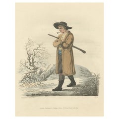
Old Antique Print of a Peasant of Upper Carniola, Slovenia, Eastern Europe, 1804
Located in Langweer, NL
Old print of a peasant of upper Carniola, Slovenia.
This print originates from 'The Costume of the Hereditary States of the House of Austria' by William Miller.
Artists and engravers: Engraved by William Ellis.
Category
Antique Early 1800s Maps
Materials
Paper
$264 Sale Price
20% Off
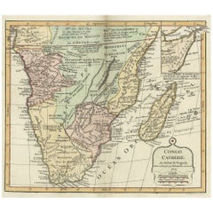
Decorative Antique Map of the Southern Part of Africa, 1806
Located in Langweer, NL
Antique map titled 'Congo, Cafrerie.'
Decorative map of the southern part of Africa by Robert de Vaugondy, revised and published by Delamarche. Source unknown, to be determined.
Artists and Engravers: Charles Francois Delamarche (1740-1817) founded the important and prolific Paris based Maison Delamarche map publishing firm in the late 18th century. A lawyer by trade Delamarche entered the map business with the acquisition from Jean-Baptiste Fortin of Robert de Vaugondy's map plates...
Category
Antique Early 1800s Maps
Materials
Paper
$529 Sale Price
20% Off
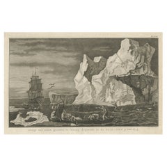
Old Print from Capt. Cooks Travels with Boats and a Ship in the South Sea, 1803
Located in Langweer, NL
Antique print titled 'Gezigt van eenen grooten Ys-klomp drijvende in de Zuid-Zee 9. jan. 1773'.
Antique print depicting boats and a ship near ice islands. Originates from 'Reizen...
Category
Antique Early 1800s Maps
Materials
Paper
$302 Sale Price
20% Off
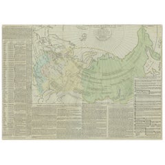
Antique Map of the Extension of the Russian Empire in the XIXth Century, 1806
Located in Langweer, NL
Antique map titled 'L'Empire Russe en Europe et en Asie'.
Map showing the extension of the Russian Empire at the beginning of the XIXth century. Several letterpress notations are...
Category
Antique Early 1800s Maps
Materials
Paper
$529 Sale Price
20% Off
Beautiful View of Pulau 'Island' Onrust, Batavia 'Jakarta, Indonesia', ca.1805
Located in Langweer, NL
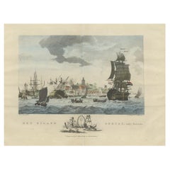
Antique print titled 'Het Eiland Onrust'. Beautiful view of the sea near Onrust Island, also known as Pulau Onrust or Pulau Kapal (ship island), Indonesia. Published by E. Maaskamp, ...
Category
Antique Early 1800s Maps
Materials
Paper
$689 Sale Price
20% Off
Decorative Antique Map of the Southern Part of South America, 1806
Located in Langweer, NL
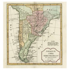
Description: Antique map titled 'Paraguay, Chili, Terre Magellan?'
Decorative map of the southern part of South America by Robert de Vaugondy, revised and published by Delamarche. Source unknown, to be determined.
Artists and Engravers: Charles Francois Delamarche (1740-1817) founded the important and prolific Paris based Maison Delamarche map publishing firm in the late 18th century. A lawyer by trade Delamarche entered the map business with the acquisition from Jean-Baptiste Fortin of Robert de Vaugondy's map plates...
Category
Antique Early 1800s Maps
Materials
Paper
$519 Sale Price
20% Off
Antique Map of the Strait of Le Maire Between Terra Fuego & Staten Island, 1803
Located in Langweer, NL
Antique map titled 'Kaart van de Good Success Baai in de Straat van Le Maire (..)'.
Antique map of the Strait of Le Maire between Terra Fuego and Staten Island. On top, various c...
Category
Antique Early 1800s Maps
Materials
Paper
$595 Sale Price
20% Off
Antique Coastal Views and a Map of Van Diemens Land (Tasmania), Australia, 1803
Located in Langweer, NL
Antique map Tasmania titled 'Kaart van Diemens Land'.
Coastal views and a map of van Diemens Land (Tasmania). Originates from 'Reizen Rondom de Waereld ...
Category
Antique Early 1800s Maps
Materials
Paper
$812 Sale Price
20% Off
Capt. Cook Aiming His Gun Near Islands of the New Hebrides, Vanuatu, 1803
Located in Langweer, NL
Antique print New Hebrides titled 'Landing op het Eiland Erramanga, een van de Nieuwe Hebriden'.
Antique print depicting the landing at one of the isl...
Category
Antique Early 1800s Maps
Materials
Paper
$595 Sale Price
40% Off
Original Engraving of Rotterdam Island, Nowadays Nomuka, Kingdom of Tonga, c1800
Located in Langweer, NL
Antique print titled 'Gezigt op het eiland Rotterdam'.
View of Rotterdam Island, Pacific. Originates from 'Reizen Rondom de Waereld door James Cook (..)'.
Rotterdam or nowadays Nomuka is a small island in the southern part of the Ha?apai group of islands in the Kingdom of Tonga. It is part of the Nomuka Group of islands, also called the ?Otu Mu?omu?a.
Nomuka, is 7 square kilometres in area and contains a large, brackish lake (Ano Lahi) in the middle, and also three other smaller lakes—Ano Ha'amea, Ano Fungalei, and Molou. There are approximately 400-500 inhabitants who subsist on fishing, farming, and remittances from family members abroad. The island has a secondary school, two primary schools, and a kindergarten. It also has seven churches.
The island is accessible by boat only. Boats leave weekly from Nuku?alofa and Lifuka, Ha?apai. There is one guesthouse on the island, and three or four small fale koloa, or convenience stores. It is also home to the Royal Nomuka Yacht Club
Notable historic visitors include Abel Tasman, Captain Cook, Captain Bligh, and William Mariner. The Dutch Abel Tasman made the first European discovery of the island on 24 January 1643. A party went ashore to get water, and the description of the huge lake they brought back afterwards leaves little doubt about the identification. Tasman called it Rotterdam island, after the city of Rotterdam, a major port in the Netherlands, and noted in his maps the indigenous name of Amamocka, a misspelling of ?a Nomuka, ?a being a subject-indicating article. We also find the name of Amorkakij for Nomuka iki.[1] Captain Bligh in the Bounty spent 3 days wooding and watering at Nomuka in April 1789. The Mutiny on the Bounty occurred the day after they left.
Nomuka is known for raising up the greatest number of church leaders for the major Christian denominations in Tonga such as Rev. Sione Lepa To'a the former president of the Free Wesleyan Church of Tonga, Rev. Seluipepeli Mafi and his son Rev Dr Feke Mafi as both former presidents of the Church of Tonga, and Pastor Tetileti Pahulu, a former president of the Seventh Day Adventist...
Category
Antique Early 1800s Maps
Materials
Paper
$188 Sale Price
52% Off
Old Map of Cook's Discovery and Charting of the East Coast of Australia, 1803
Located in Langweer, NL
Antique map titled 'Kaart van Nieuw Zuid Wales of de Oostlyke Kust van Nieuw Holland ontdekt en onderzogt door den Luitenant J. Cook met het Schip de Endeavour in het Jaar 1770'.
...
Category
Antique Early 1800s Maps
Materials
Paper
$1,653 Sale Price
20% Off
Uncommon Miniature Map of the Region around the Caspian Sea, ca.1800
Located in Langweer, NL
Uncommon miniature map of the region around the Caspian Sea.
Including the black sea and several mountains. Source unknown, to be determined.
Artist...
Category
Antique Early 1800s Maps
Materials
Paper
$179 Sale Price
20% Off
View of the Island of Tahiti, with Outrigger Canoes and Sailing Catamarans, 1803
Located in Langweer, NL
Antique print Polynesia titled 'Gezigt van het eiland Otahiti op den afstand van eene zee-mijl in het Z.O'.
View of the island of Tahiti, with outrigger canoes...
Category
Antique Early 1800s Maps
Materials
Paper
$623 Sale Price
20% Off
Antique Colourful and Decorative County Map of Bedfordshire, England, 1804
Located in Langweer, NL
Antique county map of Bedfordshire first published c.1800. Villages, towns, and cities illustrated include Bedford, Todington, and Potton.
Charl...
Category
Antique Early 1800s Maps
Materials
Paper
$307 Sale Price
20% Off
Early Coastal Views of Various Islands of the American West Coast, 1803
Located in Langweer, NL
Antique print America titled 'Gezigten der West-Kust van Amerika'.
Coastal views of various islands of the American coast. Originates from 'Reizen Rondom de Waereld door James Co...
Category
Antique Early 1800s Maps
Materials
Paper
$595 Sale Price
20% Off
Old Handcolored Print of an Inhabitant of the Lowlands of Moravia, 1804
Located in Langweer, NL
Old print of an inhabitant of the Lowlands of Moravia.
Moravia, traditional region in central Europe that served as the centre of a major medieval kingdom, known as Great Moravia, before it was incorporated into the kingdom of Bohemia in the 11th century. In the 20th century Moravia became part of the modern state of Czechoslovakia and subsequently of the Czech Republic. The region is bounded by Bohemia on the west and northwest, by Silesia on the northeast, by Slovakia on the east, and by Lower Austria on the south.
This print originates from 'The Costume of the Hereditary States of the House of Austria' by William Miller.
Artists and engravers: Engraved by William Ellis.
Category
Antique Early 1800s Maps
Materials
Paper
$226 Sale Price
20% Off
Original Copper Engraving of the Northeast Coast of Australia, 1803
Located in Langweer, NL
Antique map Australia titled 'Kaart van een gedeelte van de Kust van Nieuw Zuid Wales van Kwelling Kaap tot de Endeavour-Straat door Luit. J. Cook'.
A chart of the northeast coast...
Category
Antique Early 1800s Maps
Materials
Paper
$841 Sale Price
20% Off
Antique Map of the Harbour of Tongatabu, One of the Tonga Islands, 1803
Located in Langweer, NL
Antique map Tonga titled 'Kaart van de Haven van Tongataboo'.
Antique map of the harbour of Tongatabu, one of the Tonga Islands. Originates from 'Reizen Rondom de Waereld door Ja...
Category
Antique Early 1800s Maps
Materials
Paper
$340 Sale Price
20% Off
View of the Church of Cortona, a Town and Comune Arezzo, in Tuscany, Italy, 1800
Located in Langweer, NL
Antique print titled 'Veduta della Chiesa ed Episcopio di Cortona'.
View of the church of Cortona, a town and comune in the province of Arezzo, in Tuscany, Italy. Source unknown,...
Category
Antique Early 1800s Maps
Materials
Paper
$302 Sale Price
20% Off
Original Old China Map, From Korea and the Sea of Japan to Teypin Island, 1803
Located in Langweer, NL
Antique map titled 'China, Contains 15 Subject Provinces Including the 2 Islands of Hainan, Formosa and the Tributary Kingdoms of Corea, Tonkin'.
Old map depicting China, extendi...
Category
Antique Early 1800s Maps
Materials
Paper
$519 Sale Price
20% Off
Antique Decorative County Map of Lincolnshire, England, 1804
Located in Langweer, NL
Antique county map of Lincolnshire first published circa 1800 Cities illustrated include Grantham, Spalding, Boston, and Market Raisin.
Charles Smith was a cartographer working in...
Category
Antique Early 1800s Maps
Materials
Paper
$307 Sale Price
20% Off
Antique County Map of Derbyshire, England, 1804
Located in Langweer, NL
Antique county map of Derbyshire first published, circa 1800. Villages, towns, and cities illustrated include Chesterfield, Wirksworth, Derby, and ...
Category
Antique Early 1800s Maps
Materials
Paper
$307 Sale Price
20% Off
Map of the United Provinces & Low Countries: Early 19th Century - 1802
Located in Langweer, NL
Antique Map with Title: 'Carte Générale des Provinces Unies et des Pays-Bas'
**Publication Details:**
- **Atlas Title:** Nouvel Atlas Universel de Géographie Ancienne et Moderne
- *...
Category
Antique Early 1800s Maps
Materials
Paper
China with Hainan and Formosa Islands and the Kingdoms Corea and Tonkin, 1802
Located in Langweer, NL
Antique map titled 'China, Contains 15 Subject Provinces Including the 2 Islands of Hainan, Formosa and the Tributary Kingdoms of Korea, Tonkin'.
Old map depicting China, extendi...
Category
Antique Early 1800s Maps
Materials
Paper
$274 Sale Price
20% Off
Old Antique of the Southern Georgia and the Sandwich Islands by Capt Cook, 1803
Located in Langweer, NL
Antique map Atlantic titled 'Kaart van de Ontdekkingen gedaan in den Zuider Atlantischen Oceaan (..)'.
Antique chart depicting Southern Georgia and the Sandwich Islands. Originat...
Category
Antique Early 1800s Maps
Materials
Paper
$604 Sale Price
20% Off
Original Copper Engraved Map of the Bering Strait by Captain Cook, 1803
Located in Langweer, NL
Antique map titled 'Kaart van den Mond van Norton, en van de Engte van Bhering, toonende de meest Oostlijke Kaap van Asien, en den meest Westlijken Urthoek van Amerika'.
Map of t...
Category
Antique Early 1800s Maps
Materials
Paper
$699 Sale Price
25% Off
Original Chart Showing the Region between Cape Grenville and Cape Suckling, 1803
Located in Langweer, NL
Antique map titled 'Kaart van Cook's Rivier in het N.O. gedeelte van Amerika'.
Chart showing the region between Cape Grenville and Cape Suckling, including Whitsuntide Bay, Cape Whitsunday, Smokey Bay, Cape Douglas, Mount St. Augustine, Volcano Mountain, R. Turn-again, Cook's River, Point Possession, Anchor Point, Point Beale Cape Elizabeth...
Category
Antique Early 1800s Maps
Materials
Paper
$538 Sale Price
20% Off
Antique Decorative Map of The County of Nottinghamshire, England, 1804
Located in Langweer, NL
Antique county map of Nottinghamshire first published c.1800. Villages, towns, and cities illustrated include Worksop, Neware, Tuxford, and Maplebe...
Category
Antique Early 1800s Maps
Materials
Paper
$307 Sale Price
20% Off
Two Sheet Map of the Principality of Wales Divided into Counties, 1804
Located in Langweer, NL
A well engraved and detailed large-scale map of Wales, printed on two sheets .
The map is thoroughly detailed and includes good information regarding t...
Category
Antique Early 1800s Maps
Materials
Paper
$519 Sale Price / set
20% Off
Antique Decorative and Detailed County Map of Cumberland, England, 1804
Located in Langweer, NL
Antique county map of Cumberland first published c.1800. Villages, towns, and cities illustrated include Carlisle, Penrith, Copeland Forest, and Wigt...
Category
Antique Early 1800s Maps
Materials
Paper
$307 Sale Price
20% Off
Antique County Map of Monmouthshire, England, circa 1804
Located in Langweer, NL
Antique county map of Monmouthshire first published circa 1800. Villages, towns, and cities illustrated include Newport, Chepstow, Rockfield, and P...
Category
Antique Early 1800s Maps
Materials
Paper
$307 Sale Price
20% Off
Antique County Map of Leicestershire, England, 1804
Located in Langweer, NL
Antique county map of Leicestershire first published c.1800. Villages, towns, and cities illustrated include Lutterworth, Ashby, Hinkley, and Marke...
Category
Antique Early 1800s Maps
Materials
Paper
$307 Sale Price
20% Off
Old Map Showing the Tracks of Cook Between North America and Asia's Coast, 1803
Located in Langweer, NL
Description: Antique map titled 'Kaart van de Noord-West kust van Amerika en de Noord-Oost kust van Asia'.
Antique chart depicting America's northwest coast and Asia's northeast ...
Category
Antique Early 1800s Maps
Materials
Paper
$897 Sale Price
20% Off
Engraving of a Chinese Garden in Canton and the Festival of Death in Macao, 1808
Located in Langweer, NL
Antique print titled 'Plan d'un Jardin Chinois à Quanton, Fête des Morts à Macao'.
Two images on one sheet depicting a Chinese garden and Festival of the Death in Macao. Originat...
Category
Antique Early 1800s Maps
Materials
Paper
$396 Sale Price
20% Off
Staffordshire 1645 Hand Colored Antique Print Staffordiensis Comitatvs Map
Located in West Sussex, Pulborough
We are delighted to offer for sale this lovely antique Atlas page map of Staffordshire printed in 1645 Amsterdam Staffordiensis Comitatvs Vulgo
This o...
Category
English Georgian Antique Early 1800s Maps
Materials
Paper
$427 Sale Price
30% Off
Double Sided and Glazed Cheshire 1645 Hand Colored Antique Print Map Rare Find
Located in West Sussex, Pulborough
We are delighted to offer for sale this lovely antique Atlas page map of Cheshire printed in 1645 Amsterdam Staffordiensis Comitatvs Vulgo
I have thre...
Category
English Georgian Antique Early 1800s Maps
Materials
Paper
$427 Sale Price
30% Off
Double Sided Northamptonshire 1645 Hand Colored Antique Print Map Rare Find
Located in West Sussex, Pulborough
We are delighted to this lovely antique Atlas page map of Northamptonshire printed in 1645 Amsterdam Staffordiensis Comitatvs Vulgo
I have three of th...
Category
English Georgian Antique Early 1800s Maps
Materials
Paper
$427 Sale Price
30% Off
