Items Similar to Antique Map of the Extension of the Russian Empire in the XIXth Century, 1806


Want more images or videos?
Request additional images or videos from the seller
1 of 6
Antique Map of the Extension of the Russian Empire in the XIXth Century, 1806
About the Item
Antique map titled 'L'Empire Russe en Europe et en Asie'.
Map showing the extension of the Russian Empire at the beginning of the XIXth century. Several letterpress notations are present on the map. Surrounding letterpress explanatory text (in French) includes information about geography, history, genealogy, religion, etc.
Artists and Engravers: Published by P. Didot.
- Dimensions:Height: 20.08 in (51 cm)Width: 26.78 in (68 cm)Depth: 0 in (0.02 mm)
- Materials and Techniques:
- Period:
- Date of Manufacture:1806
- Condition:Wear consistent with age and use. Condition: Good, minor defects from handling. Please study image carefully.
- Seller Location:Langweer, NL
- Reference Number:
About the Seller
5.0
Platinum Seller
These expertly vetted sellers are 1stDibs' most experienced sellers and are rated highest by our customers.
Established in 2009
1stDibs seller since 2017
1,922 sales on 1stDibs
Typical response time: <1 hour
- ShippingRetrieving quote...Ships From: Langweer, Netherlands
- Return PolicyA return for this item may be initiated within 14 days of delivery.
More From This SellerView All
- Antique Map of the Russian Empire in Europe, ca.1780Located in Langweer, NLDescription: Antique map titled 'Bowles's New Pocket Map of the Russian Empire in Europe, Comprehending the West Part of the Empire in Asia' Large and detai...Category
Antique 1780s Maps
MaterialsPaper
- Original Antique Engraved Map of the Russian Empire, 1778Located in Langweer, NLDescription: Antique map titled 'A New and Correct Map of the Russian Empire'. Original antique map of the Russian Empire. This map originates from Moore's 'New and Complete Coll...Category
Antique 1770s Maps
MaterialsPaper
- Antique Map of the Russian Empire by R. Bonne, 1780Located in Langweer, NLAntique map titled 'Carte de l'Empire de Russie.' Drawn by R. Bonne for G. Raynal’s Atlas de Toutes les Parties Connues du Globe Terrestre, Dressé pour l'Histoire Philosophique et Po...Category
Antique Late 18th Century Maps
MaterialsPaper
- Antique Map of the Russian Empire in Europe by Vaugondy, 1750Located in Langweer, NLAntique map titled 'Partie Occidentale de l'Empire de Russie (..)'. Detailed map of the western part of Russia, extending south to the Caspian and east to Irkurkoy and Ilimskoy. A...Category
Antique 18th Century Maps
MaterialsPaper
- Detailed Original Antique Map of the Russian Empire in Asia, 1750Located in Langweer, NLAntique map titled 'Partie Orientale de l'Empire de Russie en Asie (..)'. Detailed map of the Russian Empire in Asia. Artists and Engravers: Gilles Robert de Vaugondy (1688-1766) was the head of a leading family of geographers in eighteenth century France. Gilles got his start when he jointly inherited the shop of Pierre-Moullart Sanson, grandson of the famous geographer Nicholas Sanson. The inheritance included the business, its stock of plates, and a roller press...Category
Antique 1750s Maps
MaterialsPaper
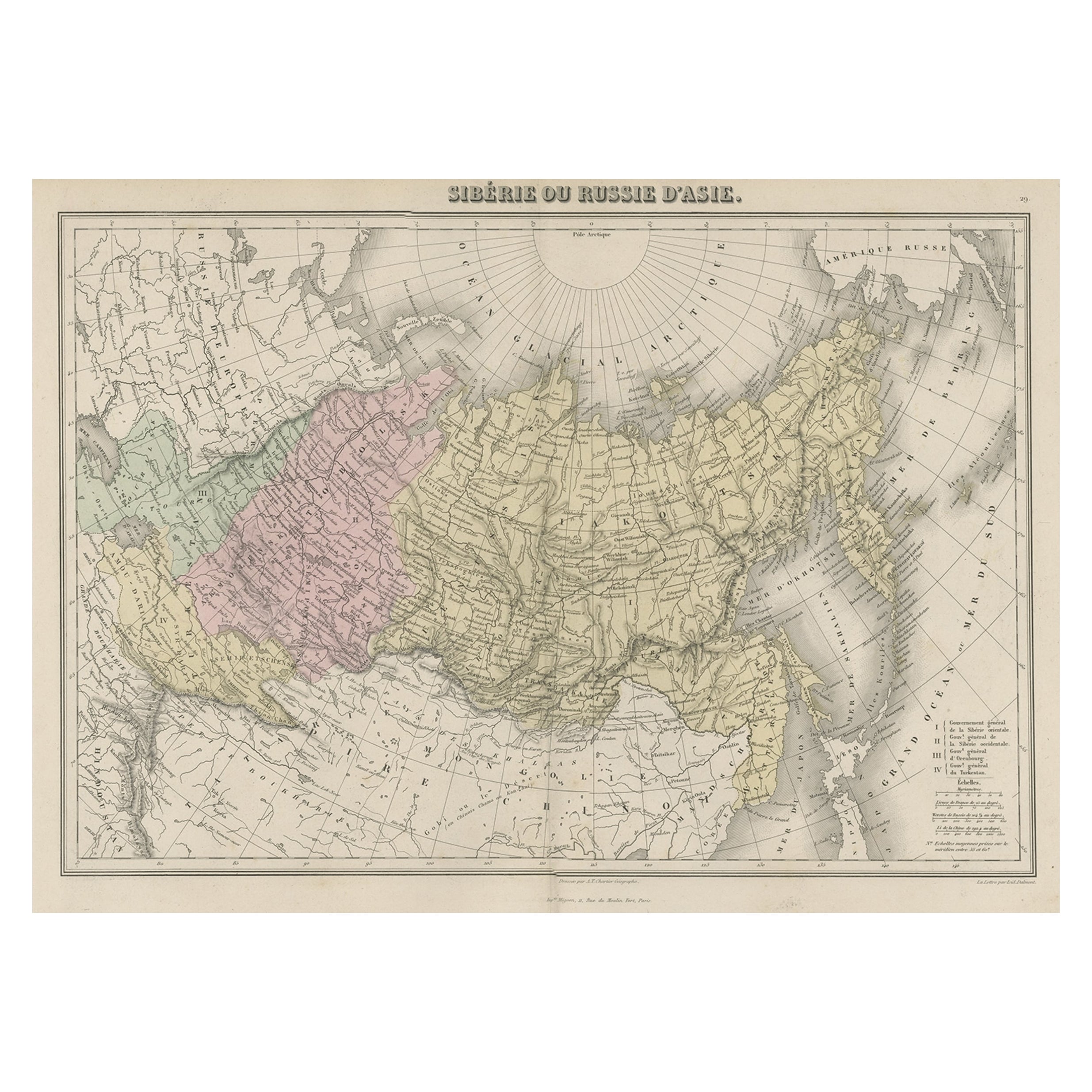
- Original Antique Map Covering the Russian Empire in Asia, 1880Located in Langweer, NLAntique map titled 'Sibérie ou Russie d'Asie'. Migeon's map covers the Russian empire in Asia from european Russia and the Ural Mountains to the Bering Strait and from the Arctic...Category
Antique 1880s Maps
MaterialsPaper


You May Also Like
- Original Antique Map of Spain and Portugal, Engraved By Barlow, 1806Located in St Annes, LancashireGreat map of Spain And Portugal Copper-plate engraving by Barlow Published by Brightly & Kinnersly, Bungay, Suffolk. 1806 Unframed.Category
Antique Early 1800s English Maps
MaterialsPaper
- Original Antique Map of Russia By Arrowsmith. 1820Located in St Annes, LancashireGreat map of Russia Drawn under the direction of Arrowsmith Copper-plate engraving Published by Longman, Hurst, Rees, Orme and Brown, 1820 Unframed.Category
Antique 1820s English Maps
MaterialsPaper
- Antique 18th Century Map of the Province of Pensilvania 'Pennsylvania State'Located in Philadelphia, PAA fine antique of the colony of Pennsylvania. Noted at the top of the sheet as a 'Map of the province of Pensilvania'. This undated and anonymous map is thought to be from the Gentleman's Magazine, London, circa 1775, although the general appearance could date it to the 1760's. The southern boundary reflects the Mason-Dixon survey (1768), the western boundary is placed just west of Pittsburgh, and the northern boundary is not marked. The map has a number of reference points that likely refer to companion text and appear to be connected to boundaries. The western and southern boundaries are marked Q, R, S, for example. A diagonal line runs from the Susquehanna R to the Lake Erie P. A broken line marked by many letters A, B, N, O, etc., appears in the east. There are no latitude or longitude markings, blank verso. Framed in a shaped contemporary gilt wooden frame and matted under a cream colored matte. Bearing an old Graham Arader Gallery...Category
Antique 18th Century British American Colonial Maps
MaterialsPaper
- Map of the Republic of GenoaLocated in New York, NYFramed antique hand-coloured map of the Republic of Genoa including the duchies of Mantua, Modena, and Parma. Europe, late 18th century. Dimension: 25...Category
Antique Late 18th Century European Maps
- Antique Map of Principality of MonacoBy Antonio Vallardi EditoreLocated in Alessandria, PiemonteST/619 - "Old Geographical Atlas of Italy - Topographic map of ex-Principality of Monaco" - ediz Vallardi - Milano - A somewhat special edition ---Category
Antique Late 19th Century Italian Other Prints
MaterialsPaper
- Original Antique Map of The World by Thomas Clerk, 1817Located in St Annes, LancashireGreat map of The Eastern and Western Hemispheres On 2 sheets Copper-plate engraving Drawn and engraved by Thomas Clerk, Edinburgh. Published by Mackenzie And Dent, 1817 ...Category
Antique 1810s English Maps
MaterialsPaper


Recently Viewed
View AllMore Ways To Browse
French Extension
Russia Empire
Russian Empire Furniture
Antique Russian Empire
Antique Russian Map
Antique Map Russia
Antique Map Of Russia
Antique Maps Of Russia
Antique Genealogy
Letterpress Furniture
Asie Antique
Antique Maps Of Russian Empire
Wood And Sons Plate
Antique Caribbean
Holland Utrecht
Antique Paper Globe
Small Antique Globes
Antique Map India