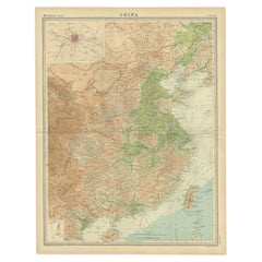
Items Similar to China with Hainan and Formosa Islands and the Kingdoms Corea and Tonkin, 1802

Want more images or videos?
Request additional images or videos from the seller
1 of 5
China with Hainan and Formosa Islands and the Kingdoms Corea and Tonkin, 1802
About the Item
Antique map titled 'China, Contains 15 Subject Provinces Including the 2 Islands of Hainan, Formosa and the Tributary Kingdoms of Korea, Tonkin'.
Old map depicting China, extending from Korea and the Sea of Japan to Teypin Island in the south.
Originates from Wilkinson's 'A General Atlas, being a Collection of Maps of the World and Quarters the Principal Empires, Kingdoms &c. with their several Provinces & other subdivisions, correctly delineated'.
- Dimensions:Height: 10.04 in (25.5 cm)Width: 12.21 in (31 cm)Depth: 0 in (0.02 mm)
- Materials and Techniques:
- Period:
- Date of Manufacture:1802
- Condition:One corner with a tear but well outside the image in a wide margin. One vertical fold from the book in which the map was issued.
- Seller Location:Langweer, NL
- Reference Number:
About the Seller
5.0
Platinum Seller
These expertly vetted sellers are 1stDibs' most experienced sellers and are rated highest by our customers.
Established in 2009
1stDibs seller since 2017
1,928 sales on 1stDibs
Typical response time: <1 hour
- ShippingRetrieving quote...Ships From: Langweer, Netherlands
- Return PolicyA return for this item may be initiated within 14 days of delivery.
More From This SellerView All
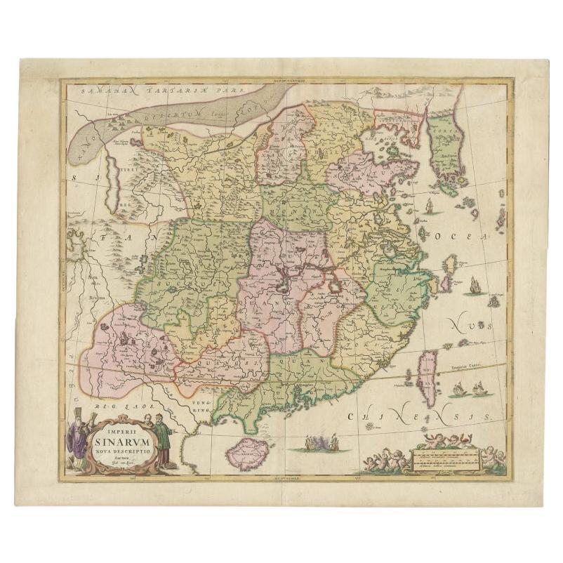
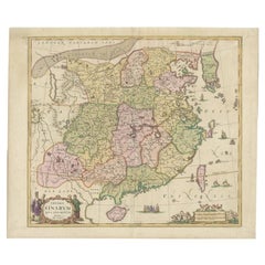
- Antique Map of China and Korea incl Formosa and Hainan, by Janssonius, ca.1650Located in Langweer, NLAntique map titled 'Imperii Sinarum Nova Descriptio'. Beautiful map of China and Korea, much detail troughout the map. Including the Islands of Formosa (Taiwan) and Hainan. The Great...Category
Antique 17th Century Maps
MaterialsPaper
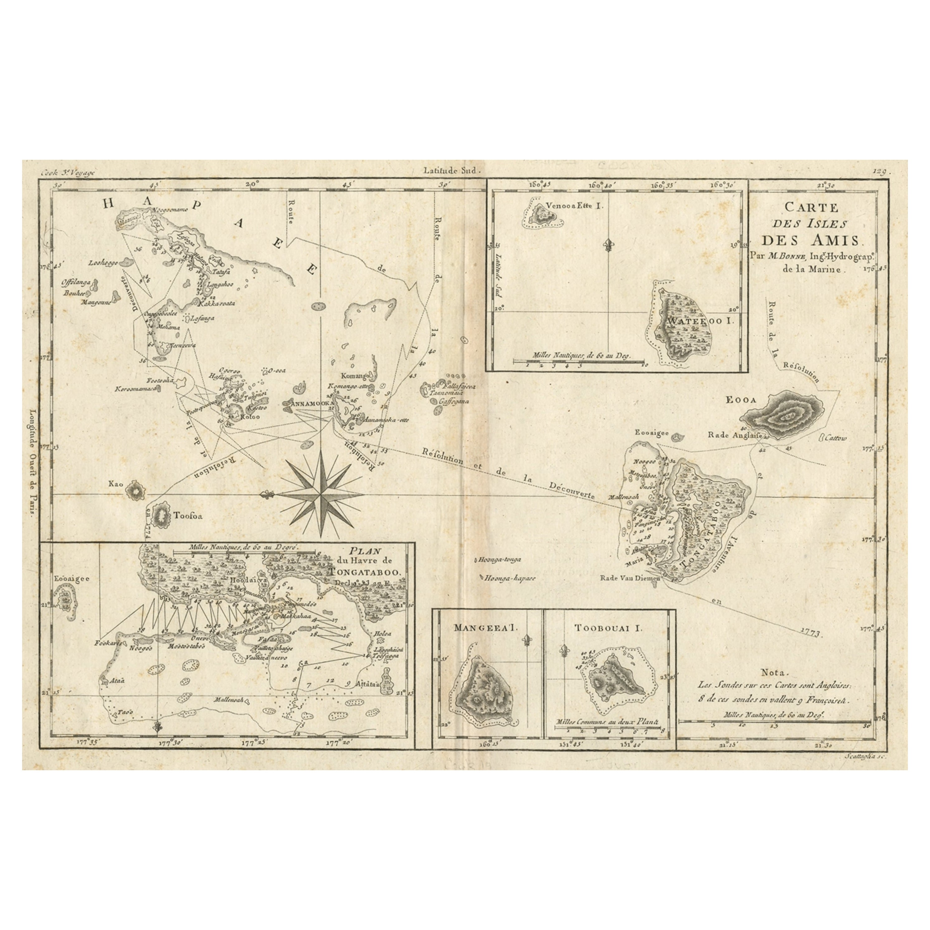
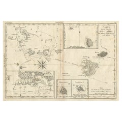
- Old Map of the Kingdom of Tonga, Also Known as the Friendly Islands, ca.1780Located in Langweer, NLAntique print, titled: 'Carte des Isles des Amis.' Map of the Kingdom of Tonga, also known as the Friendly Islands, and one of the last hereditary monarchies. Cook named this gro...Category
Antique 1780s Maps
MaterialsPaper
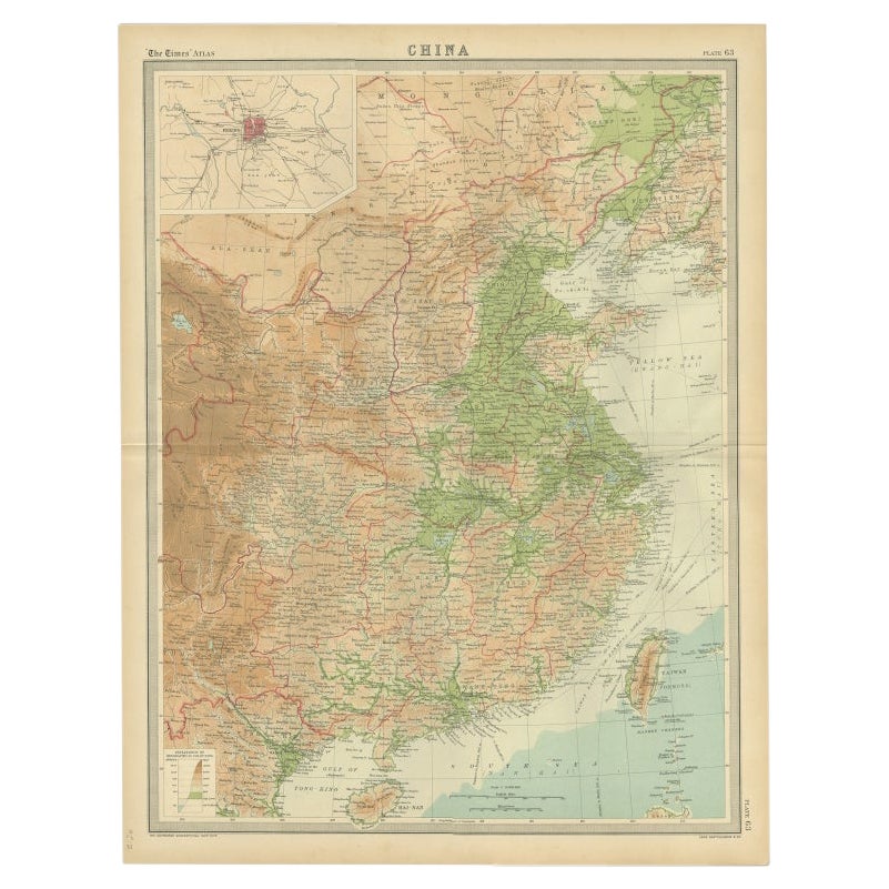
- Original Old Map of Eastern China, Also Depicting Taiwan 'Formosa', 1922Located in Langweer, NLLarge map of China titled 'China - Peking'. Old map of eastern China depicting Kiangsi, Chekiang, Fukien, Kwangtung, Taiwan (Formosa) and surroundings. With inset map of Peking. This...Category
20th Century Maps
MaterialsPaper
- Antique Map of the Tonkin River ‘Vietnam’ by J.N. Bellin, 1764Located in Langweer, NLOne of the maps produced by Bellin for Prevost d'Exiles' influential travel book, ‘L'Histoire Generale des Voyages’. This map depicts part of Southeast Asia, most likely northern Vie...Category
Antique Mid-18th Century Maps
MaterialsPaper
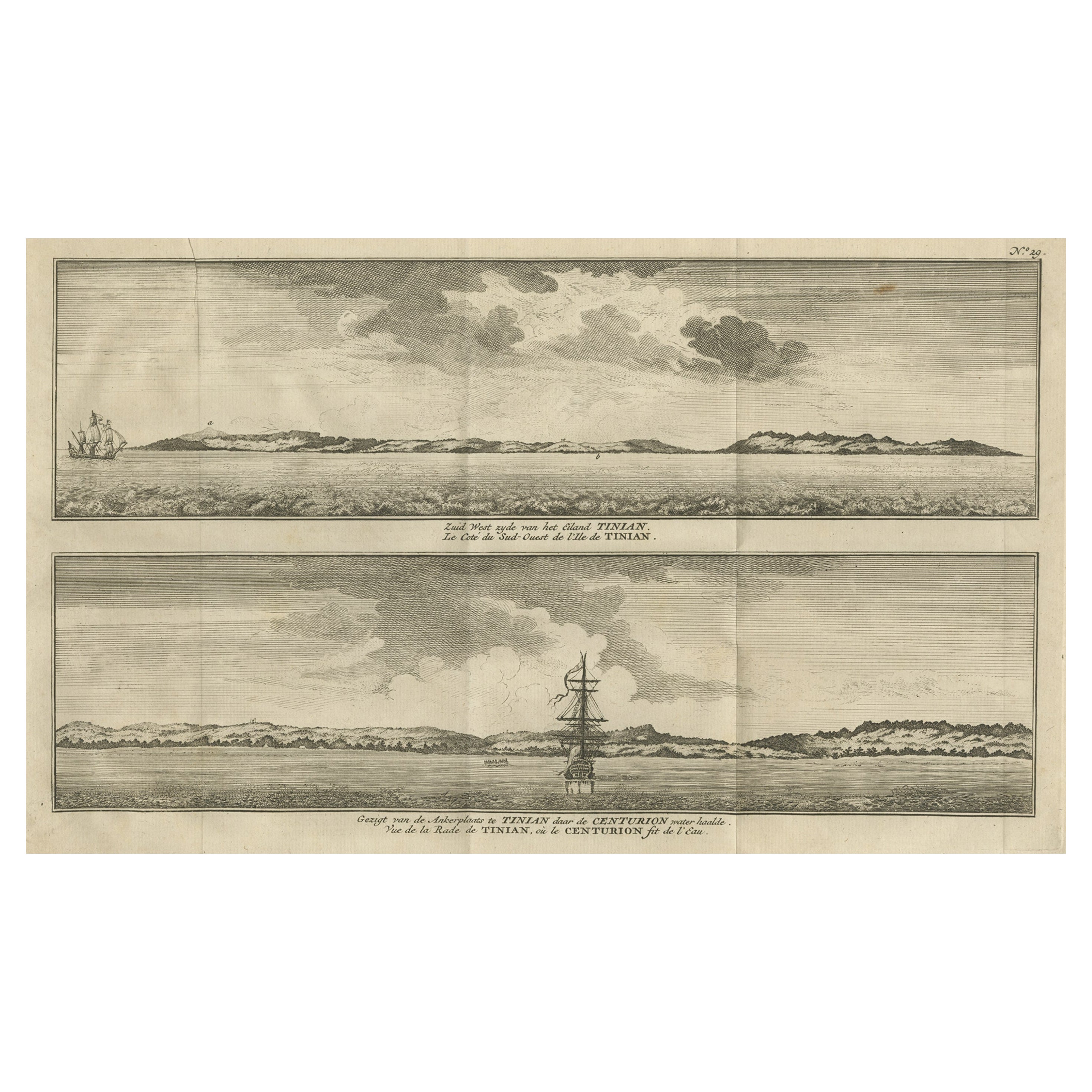
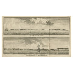
- Antique Print with Views of Tinian Island, the Northern Mariana Islands, 1749Located in Langweer, NLAntique print titled 'Le cote du sud-ouest de l'Ile de Tinian' and 'Vue de la rade de Tinian, ou le Centurion fit de l'eau.' Views of the south-west side of the island of Tinian and a view of the anchorage of Tinian, where the Centurion got water. This print originates from 'Reize rondsom de Werreld (..)' by George Anson, published 1749. Tinian is one of the three principal islands of the Commonwealth of the Northern Mariana Islands...Category
Antique 18th Century Prints
MaterialsPaper
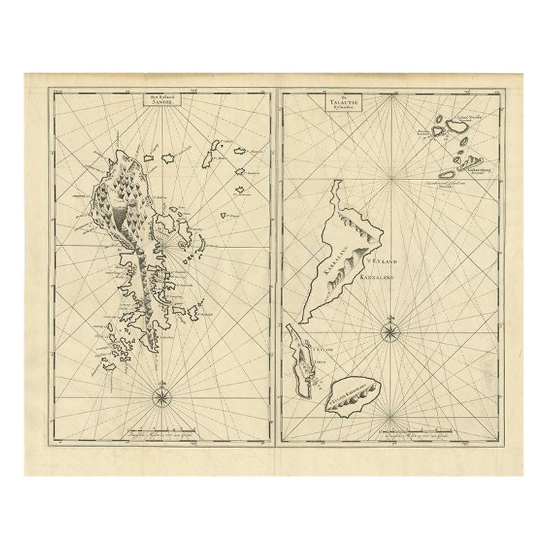
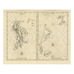
- Antique Map of Sangir Island and the Talaud Islands by Valentijn, 1726Located in Langweer, NLAntique map titled 'Het Eyland Sangir & De Talautse Eylanden'. Two maps on one sheet. To the left, a map of Sangir Island, Indonesia. To the right, a map of the Talaud Islands, Indon...Category
Antique 18th Century Maps
MaterialsPaper

You May Also Like
- The Kingdom of Naples and Southern Italy: A Hand-Colored 18th Century Homann MapBy Johann Baptist HomannLocated in Alamo, CA"Novissima & exactissimus Totius Regni Neapolis Tabula Presentis Belli Satui Accommo Data" is a hand colored map of southern Italy and the ancient Kingdom of Naples created by Johann...Category
Antique Early 18th Century German Maps
MaterialsPaper
- Hand-Colored 18th Century Homann Map of Denmark and Islands in the Baltic SeaBy Johann Baptist HomannLocated in Alamo, CAAn 18th century copper plate hand-colored map entitled "Insulae Danicae in Mari Balthico Sitae utpote Zeelandia, Fionia, Langelandia, Lalandia, Falstria, Fembria Mona" created by Joh...Category
Antique Early 18th Century German Maps
MaterialsPaper
- St. Christophe 'St. Kitts' Island: An 18th Century Hand-colored Map by BellinBy Jacques-Nicolas BellinLocated in Alamo, CAJacques Bellin's copper-plate map of the Caribbean island of Saint Kitts entitled "Carte De De l'Isle St. Christophe Pour servir á l'Histoire Genle. des V...Category
Antique Mid-18th Century French Maps
MaterialsPaper
- Dendy Sadler, "The Royal and Ancient" Golf PrintLocated in Oxfordshire, GBGolf print 'The Royal and Ancient' after Dendy Sadler. A good oak framed artist proof golf etching by James Dobie after the painting by Dendy Sadler. The ...Category
Vintage 1910s English Sporting Art Sports Equipment and Memorabilia
MaterialsOak, Paper
- H.M. Tomlinson "The Sea and The Jungle" 1st Edition Woodcuts by Clare LeightonBy TomlinsonLocated in San Francisco, CAH.M. Tomlinson "The Sea and The Jungle" First Edition with woodcuts by Clare Leighton, circa 1930 Rare First Edition. Very good condition. Fantastic woodcuts by noted artist Clare...Category
Early 20th Century American American Classical Books
MaterialsOther
- Chessboard "Homaage á Marcel Duchamp" with the L.H.O.O.Q. Mustache by ArmanBy ArmanLocated in Philadelphia, PAA shadow-box framed chessboard with the L.H.O.O.Q. mustache by Arman (1928-2005) entitled "Homaage á Marcel Duchamp". A screen-print on Skivertex leather chessboard. Framed behind g...Category
Vintage 1970s American Modern Prints
MaterialsLeather


Recently Viewed
View AllMore Ways To Browse
Antique Quarters
Japanese Empire
Antique Furniture From Korea
Atlas China
Map Of Korea
Korean Map
Map Korea
Korea Antique Map
Antique Map Of Korea
Map South China Sea
Large Antique Compass
Antique New England Maps
Antique Map New England
Antique Map Of New England
Antique Maps New England
Antique Map Of Greece
Antique Greek Map
Antique Greece Map