Items Similar to Old Antique of the Southern Georgia and the Sandwich Islands by Capt Cook, 1803

Want more images or videos?
Request additional images or videos from the seller
1 of 7
Old Antique of the Southern Georgia and the Sandwich Islands by Capt Cook, 1803
About the Item
Antique map Atlantic titled 'Kaart van de Ontdekkingen gedaan in den Zuider Atlantischen Oceaan (..)'.
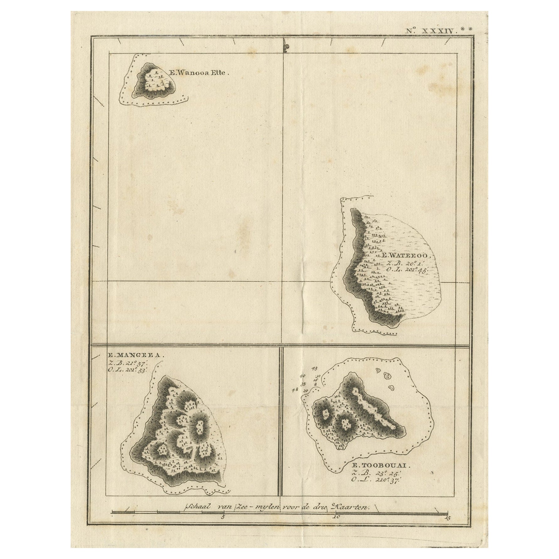
Antique chart depicting Southern Georgia and the Sandwich Islands. Originates from 'Reizen Rondom de Waereld door James Cook (..)'.
Artists and Engravers: Translated by J.D. Pasteur. Published by Honkoop, Allart en Van Cleef.
- Dimensions:Height: 13.98 in (35.5 cm)Width: 19.69 in (50 cm)Depth: 0 in (0.02 mm)
- Materials and Techniques:
- Period:
- Date of Manufacture:1803
- Condition:Condition: Good, general age-related toning. Some wear, please study image carefully.
- Seller Location:Langweer, NL
- Reference Number:
About the Seller
5.0
Platinum Seller
These expertly vetted sellers are 1stDibs' most experienced sellers and are rated highest by our customers.
Established in 2009
1stDibs seller since 2017
1,919 sales on 1stDibs
Typical response time: <1 hour
- ShippingRetrieving quote...Ships From: Langweer, Netherlands
- Return PolicyA return for this item may be initiated within 14 days of delivery.
More From This SellerView All
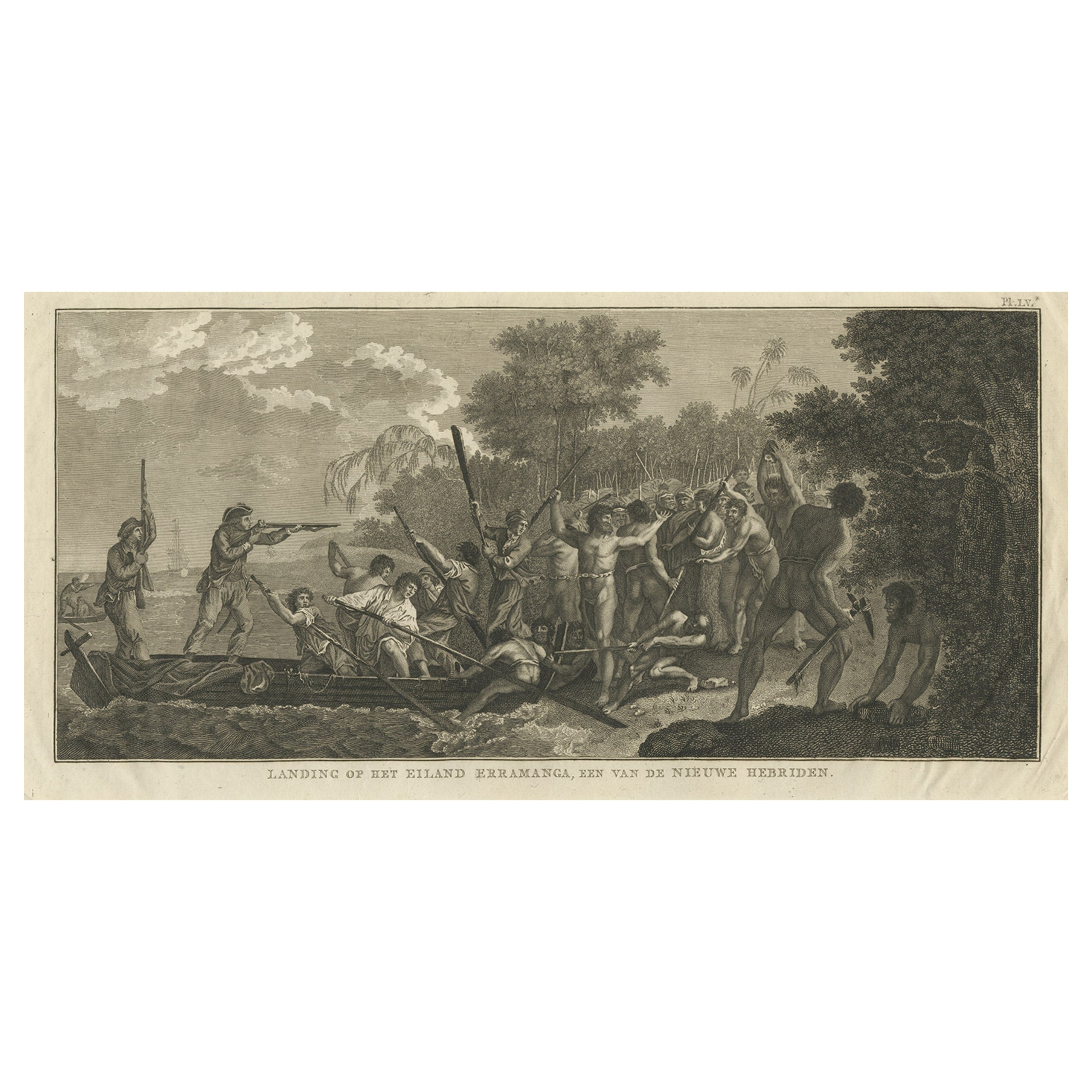
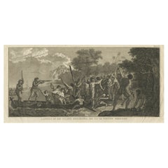
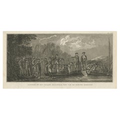
- Capt. Cook Aiming His Gun Near Islands of the New Hebrides, Vanuatu, 1803Located in Langweer, NLAntique print New Hebrides titled 'Landing op het Eiland Erramanga, een van de Nieuwe Hebriden'. Antique print depicting the landing at one of the isl...Category
Antique Early 1800s Prints
MaterialsPaper
- Antique Map of Suffren Island by Cook, 1803Located in Langweer, NLAntique map Australia titled 'Gezigt van het Eil. Suffren'. Antique map of Suffren Island. Originates from 'Reizen Rondom de Waereld door James C...Category
Antique 19th Century Maps
MaterialsPaper
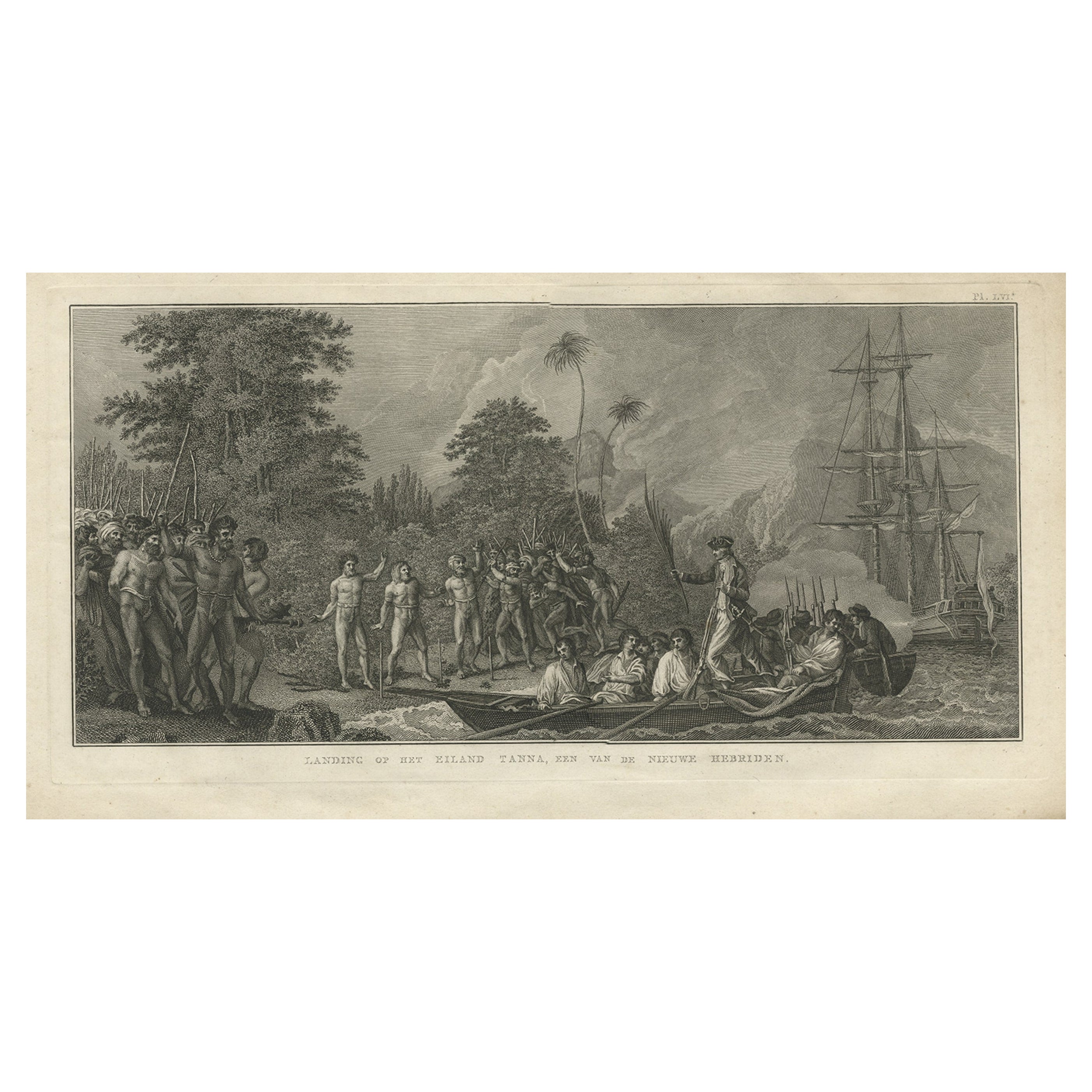
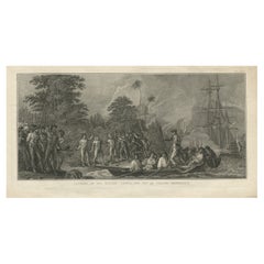
- Antique Print of the Landing at Tanna Island by Cook, 1803Located in Langweer, NLAntique print New Hebrides titled 'Landing op het Eiland Tanna, een van de Nieuwe Hebriden'. Antique print depicting the landing at one of the islands of the New Hebrides, Vanuatu. O...Category
Antique 19th Century Prints
MaterialsPaper
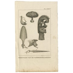
- Antique Print depicting Tools of the Sandwich Islands by Cook '1803'Located in Langweer, NLAntique print titled 'Werktuigen van de Sandiwch-Eilanders'. This print depicts various tools of the Inhabitants of the Sandwich Islands. Originates f...Category
Antique Early 19th Century Dutch Prints
MaterialsPaper
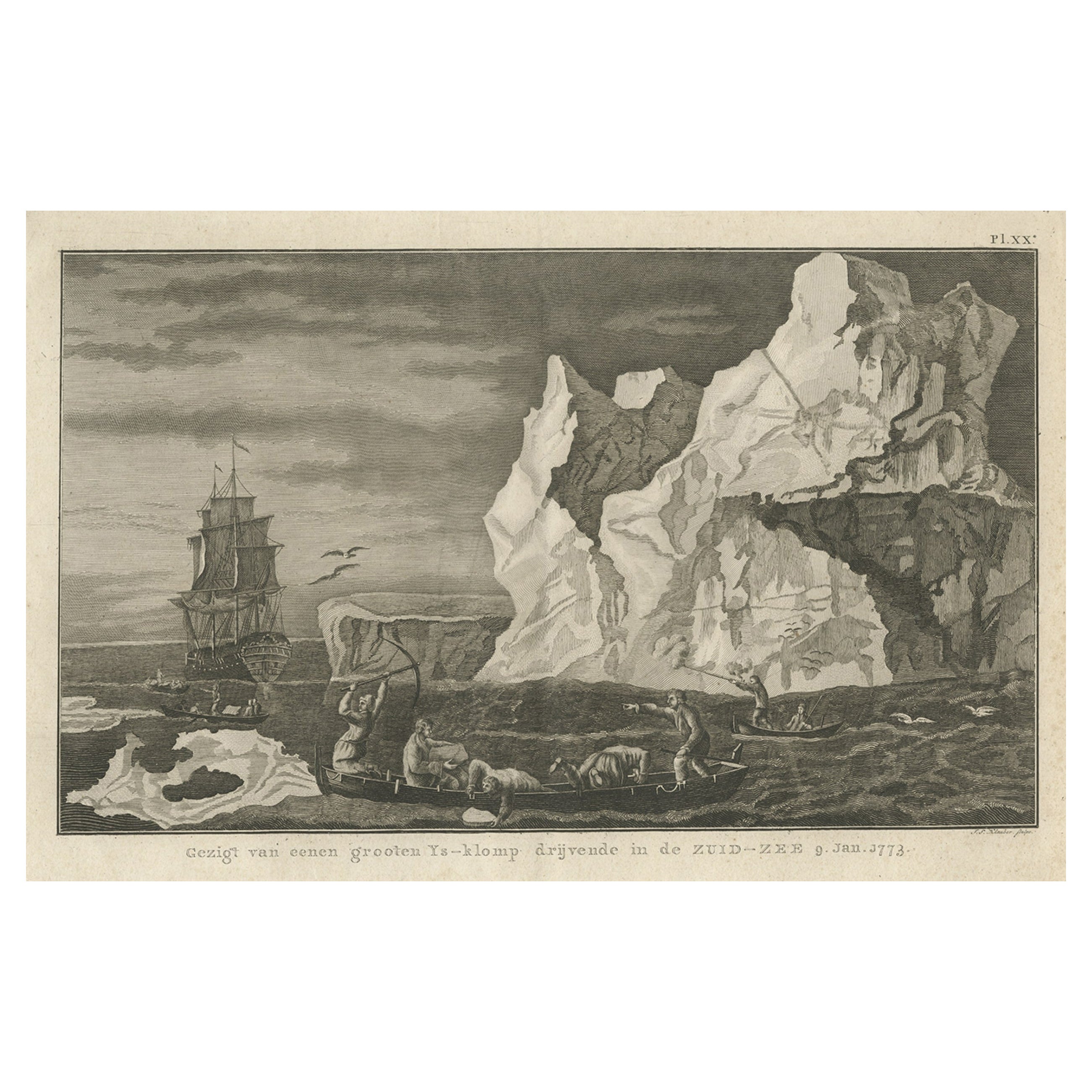
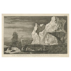
- Old Print from Capt. Cooks Travels with Boats and a Ship in the South Sea, 1803Located in Langweer, NLAntique print titled 'Gezigt van eenen grooten Ys-klomp drijvende in de Zuid-Zee 9. jan. 1773'. Antique print depicting boats and a ship near ice islands. Originates from 'Reizen...Category
Antique Early 1800s Prints
MaterialsPaper
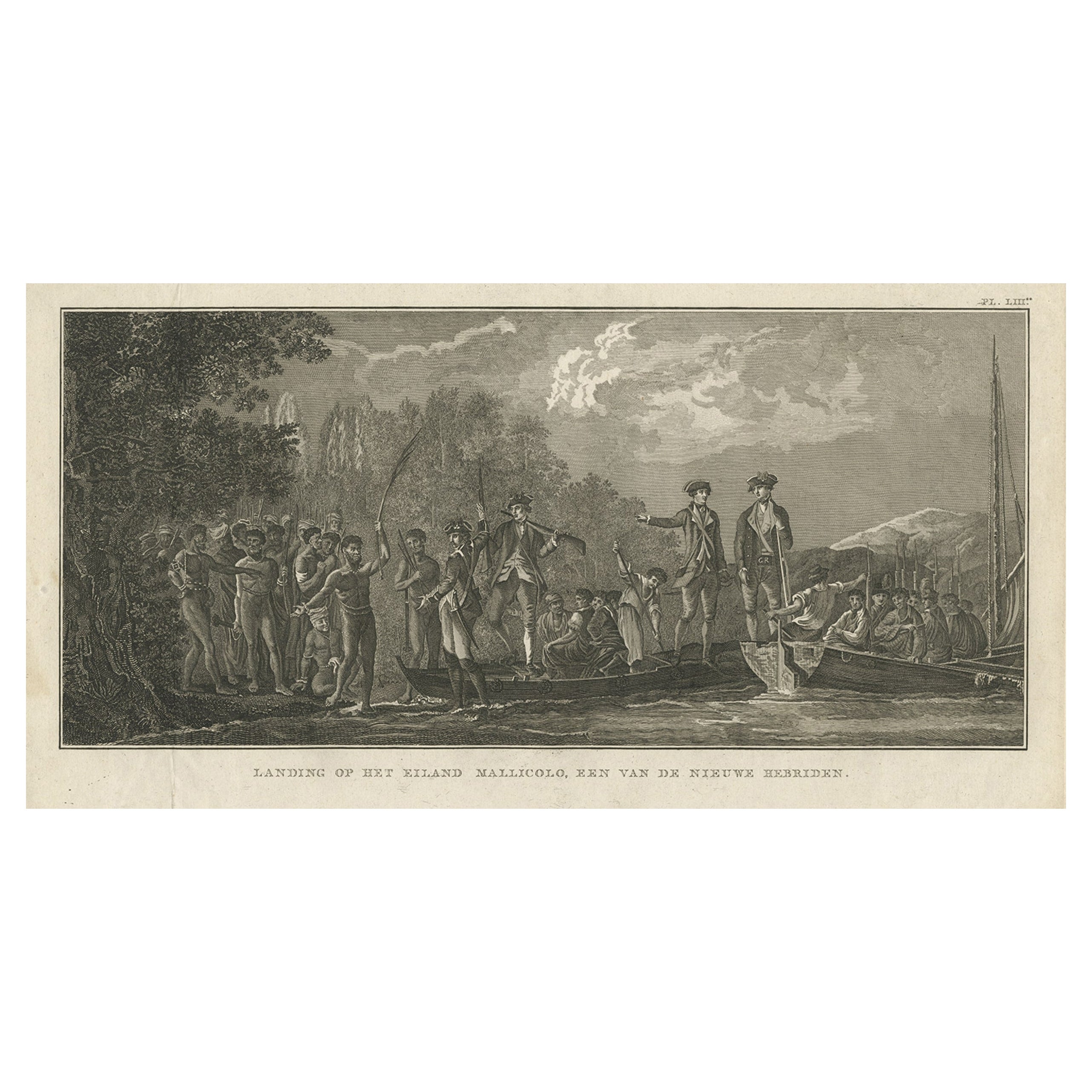
- Antique Print of the Landing at Malakula Island, Vanuatu, by Cook, 1803Located in Langweer, NLAntique print New Hebrides titled 'Landing op het Eiland Mallicolo, een van de Nieuwe Hebriden'. Antique print depicting the landing at one of the islands of the New Hebrides, Vanuat...Category
Antique 19th Century Prints
MaterialsPaper

You May Also Like
- The Kingdom of Naples and Southern Italy: A Hand-Colored 18th Century Homann MapBy Johann Baptist HomannLocated in Alamo, CA"Novissima & exactissimus Totius Regni Neapolis Tabula Presentis Belli Satui Accommo Data" is a hand colored map of southern Italy and the ancient Kingdom of Naples created by Johann...Category
Antique Early 18th Century German Maps
MaterialsPaper
- Old Nautical Print Depicting the Bombardment of Cadiz by the French Navy 1823Located in Milan, ITPrint by engraving on copper plate of the first half of the 19th century, depicting the bombardment of Cadiz by the French Navy, 23 September 1823. The print is signed peint par Crep...Category
Antique 1830s French Nautical Objects
MaterialsPaper
- Captain Cook's Exploration of Tahiti 18th C. Hand-Colored Map by BellinBy Jacques-Nicolas BellinLocated in Alamo, CAThis beautiful 18th century hand-colored copper plate engraved map is entitled "Carte de l'Isle de Taiti, par le Lieutenant J. Cook" was created by Jacques Nicolas Bellin and publish...Category
Antique Mid-18th Century French Maps
MaterialsPaper
- Hand-Colored 18th Century Homann Map of Denmark and Islands in the Baltic SeaBy Johann Baptist HomannLocated in Alamo, CAAn 18th century copper plate hand-colored map entitled "Insulae Danicae in Mari Balthico Sitae utpote Zeelandia, Fionia, Langelandia, Lalandia, Falstria, Fembria Mona" created by Joh...Category
Antique Early 18th Century German Maps
MaterialsPaper
- Southern Greece: A Large 17th C. Hand-colored Map by Sanson and JaillotBy Nicolas SansonLocated in Alamo, CAThis large original hand-colored copperplate engraved map of southern Greece and the Pelopponese Peninsula entitled "La Moree Et Les Isles De Zante, Cefalonie, Ste. Marie, Cerigo & C...Category
Antique 1690s French Maps
MaterialsPaper
- Original Antique Map of The World by Thomas Clerk, 1817Located in St Annes, LancashireGreat map of The Eastern and Western Hemispheres On 2 sheets Copper-plate engraving Drawn and engraved by Thomas Clerk, Edinburgh. Published by Mackenzie And Dent, 1817 ...Category
Antique 1810s English Maps
MaterialsPaper


Recently Viewed
View AllMore Ways To Browse
Georgian Antique Doors
Antique Sandwich
Cook Islands
Antique Van Cleef
James Cook Map
Georgia Map
Antique Georgia Maps
Antique Georgia Map
Maps Of Georgia
Antique Map Of Georgia
18th Century Southern Antiques
Antique French Globe
South African Antique Furniture
Antique Furniture South Africa
Used Booksellers
Used Bookseller
Antique British Maps
Antique 17th Century World Map