Items Similar to Original Map of the Kingdom of Bohemia, with Silesia, Moravia and Lusatia, 1804


Want more images or videos?
Request additional images or videos from the seller
1 of 5
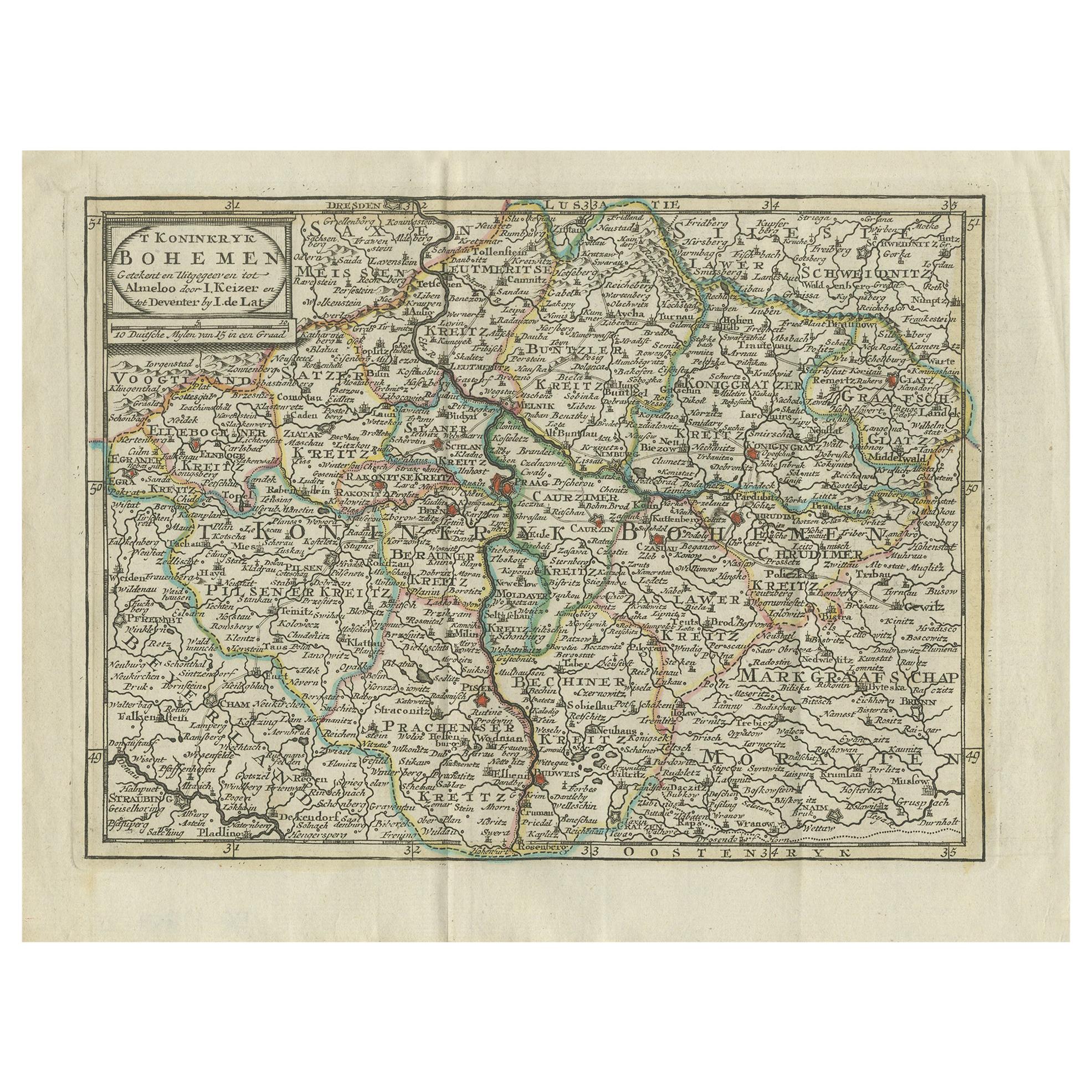
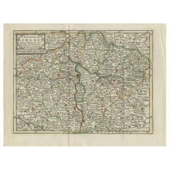
Original Map of the Kingdom of Bohemia, with Silesia, Moravia and Lusatia, 1804
About the Item
Antique map titled 'The Kingdom of Bohemia with the Duchy of Silesia and the Marquisates of Moravia and Lusatia.'
Map of the Kingdom of Bohemia, with Silesia, Moravia and Lusatia. This map originates from 'A new universal atlas, exhibiting all the empires, kingdoms, states, republics, &c. &c. in the whole World; being a complete collection of the most approved maps extant; corrected with the greatest care, and augmented from the last edition of D'Anville and Robert (de Vaugondy) with many improvements by Major James Rennel, and other eminent geographers, including all the tracks and new discoveries of the British circumnavigators, Biron, Wallis, Carteret, Captain James Cook, Vancouver, Perouse, &c. &c. 6th Ed. (..)' London, R. Laurie & J. Whittle, 1804. Map dated 1794.
Artists and Engravers: Cartographer: 'Thomas Jefferys'. Thomas Jefferys (c.1719 - 1771), "Geographer to King George III", was an English cartographer who was the leading map supplier of his day. He engraved and printed maps for government and other official bodies and produced a wide range of commercial maps and atlases, especially of North America. Publisher: Laurie & Whittle and Thomas Kitchin. Robert Laurie (c. 1755–1836) was an Anglo-Scottish mezzotint engraver and publisher. He signed his name as Lowery, Lowry, Lowrie, Lawrey, Lawrie, or Laurie. James Whittle, English publisher.
- Dimensions:Height: 21.38 in (54.3 cm)Width: 27.37 in (69.5 cm)Depth: 0 in (0.02 mm)
- Materials and Techniques:
- Period:
- Date of Manufacture:1804
- Condition:Wear consistent with age and use. Condition: Good, given age. Original middle fold, as issued. Paper separation in lower and top middle fold margin, backed. 2 Small tears in top paper edges, not effecting image. Contemporary hand coloring. General age-related toning.
- Seller Location:Langweer, NL
- Reference Number:
About the Seller
5.0
Platinum Seller
These expertly vetted sellers are 1stDibs' most experienced sellers and are rated highest by our customers.
Established in 2009
1stDibs seller since 2017
1,929 sales on 1stDibs
Typical response time: <1 hour
- ShippingRetrieving quote...Ships From: Langweer, Netherlands
- Return PolicyA return for this item may be initiated within 14 days of delivery.
More From This SellerView All
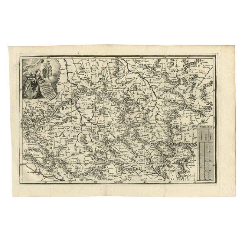
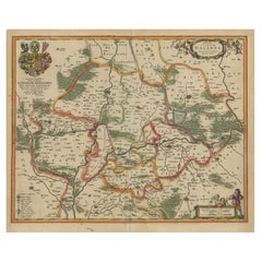
- Antique Uncommon Map of Bohemia, Moravia and Silesia, 1699Located in Langweer, NLAntique map titled 'B. V. Boleslaviensis in Bohemia, Moravia et Silesia (..).' Detailed uncommon map of the Bohemia, Moravia and Silesia. Source unknown, to be determined. Artists...Category
Antique 17th Century Maps
MaterialsPaper
- Antique Map of the Kingdom of Bohemia by Keizer & de Lat, 1788Located in Langweer, NLAntique map titled 't Koninkryk Bohemen (..)'. Uncommon original antique map of the Kingdom of Bohemia. This map originates from 'Nieuwe Natuur- Geschied- en Handelkundige Zak- en Re...Category
Antique Late 18th Century Maps
MaterialsPaper
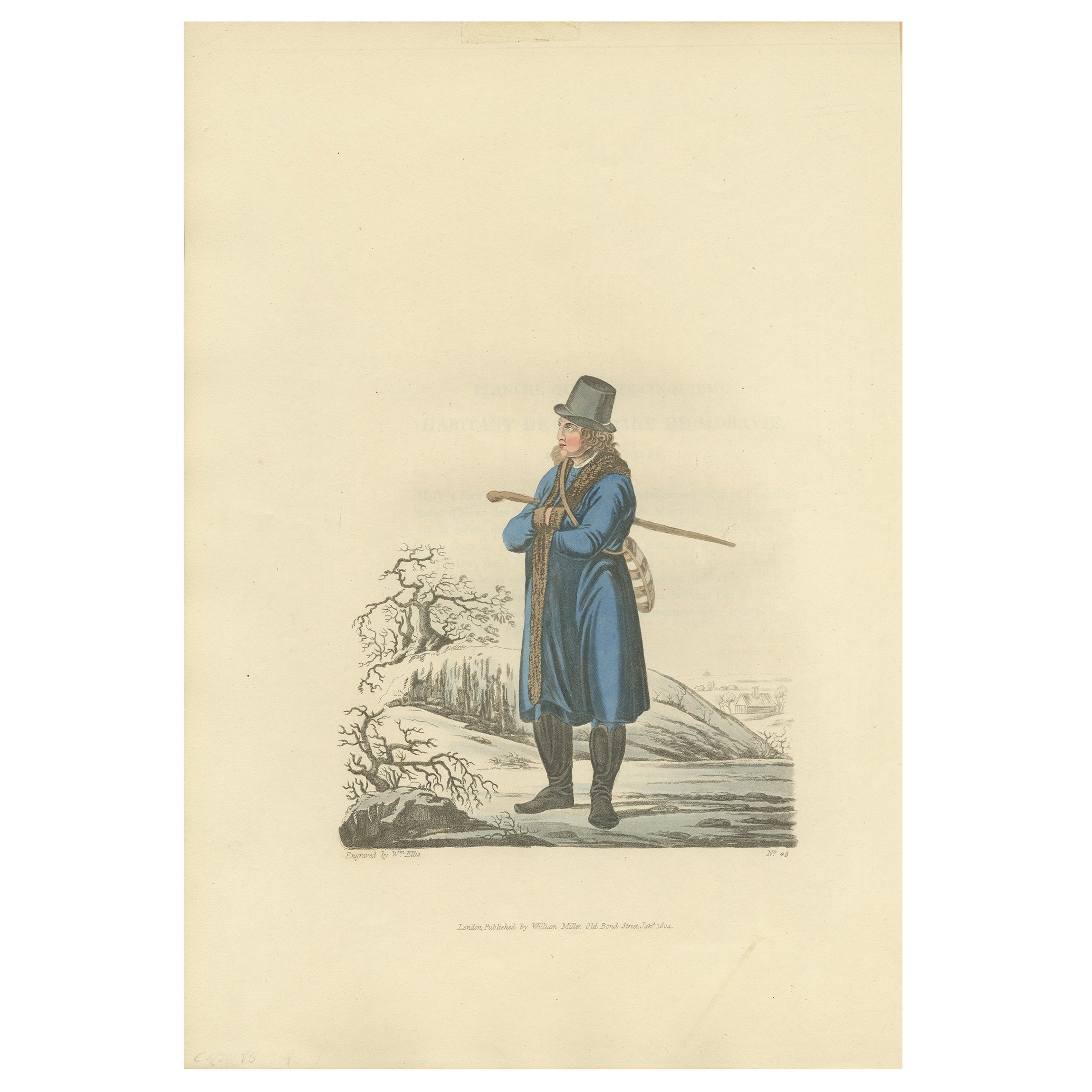
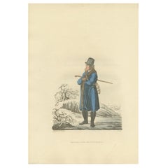
- Old Handcolored Print of an Inhabitant of the Lowlands of Moravia, 1804Located in Langweer, NLOld print of an inhabitant of the Lowlands of Moravia. Moravia, traditional region in central Europe that served as the centre of a major medieval kingdom, known as Great Moravia, before it was incorporated into the kingdom of Bohemia in the 11th century. In the 20th century Moravia became part of the modern state of Czechoslovakia and subsequently of the Czech Republic. The region is bounded by Bohemia on the west and northwest, by Silesia on the northeast, by Slovakia on the east, and by Lower Austria on the south. This print originates from 'The Costume of the Hereditary States of the House of Austria' by William Miller. Artists and engravers: Engraved by William Ellis.Category
Antique Early 1800s Prints
MaterialsPaper
- Antique Map of Lower Silesia of The Famous Mapmaker Blaeu, c.1650Located in Langweer, NLAntique map titled 'Ducatus Silesiae Wolanus'. \ Antique map depicting lower Silesia with the cities of Wolow (Wohlau), Winsko (Winzig), Herrnstadt, Chobie (Koben), Lubin (Lüben), R...Category
Antique 17th Century Maps
MaterialsPaper
- Original Antique Map of the United Kingdom and Ireland, Published in 1875Located in Langweer, NLAntique map titled 'Iles Britanniques ou Royaume-Uni de la Grande Bretagne (..)'. Large map of the United Kingdom and Ireland. This map originates from...Category
Antique Late 19th Century Maps
MaterialsPaper
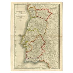
- Engraved Large Map of The Kingdom of Portugal Original Handcolored, 1854Located in Langweer, NLAntique map titled 'Mappa Corografica do Reino de Portugal - Chorographical map of the Kingdom of Portugal divided into its Grand Provinces.' Large map of...Category
Antique 1850s Maps
MaterialsPaper

You May Also Like
- The Kingdom of Naples and Southern Italy: A Hand-Colored 18th Century Homann MapBy Johann Baptist HomannLocated in Alamo, CA"Novissima & exactissimus Totius Regni Neapolis Tabula Presentis Belli Satui Accommo Data" is a hand colored map of southern Italy and the ancient Kingdom of Naples created by Johann...Category
Antique Early 18th Century German Maps
MaterialsPaper
- Original Antique Map of The World by Thomas Clerk, 1817Located in St Annes, LancashireGreat map of The Eastern and Western Hemispheres On 2 sheets Copper-plate engraving Drawn and engraved by Thomas Clerk, Edinburgh. Published by Mackenzie And Dent, 1817 ...Category
Antique 1810s English Maps
MaterialsPaper
- Map of the Republic of GenoaLocated in New York, NYFramed antique hand-coloured map of the Republic of Genoa including the duchies of Mantua, Modena, and Parma. Europe, late 18th century. Dimension: 25...Category
Antique Late 18th Century European Maps
- Original Antique Map of Italy. C.1780Located in St Annes, LancashireGreat map of Italy Copper-plate engraving Published C.1780 Unframed.Category
Antique Early 1800s English Georgian Maps
MaterialsPaper

- Original Antique Map of Asia. C.1780Located in St Annes, LancashireGreat map of Asia Copper-plate engraving Published C.1780 Two small worm holes to right side of map Unframed.Category
Antique Early 1800s English Georgian Maps
MaterialsPaper

- Original Antique Map of India. C.1780Located in St Annes, LancashireGreat map of India Copper-plate engraving Published C.1780 Three small worm holes to right side of map and one bottom left corner Unframed.Category
Antique Early 1800s English Georgian Maps
MaterialsPaper


Recently Viewed
View AllMore Ways To Browse
King Of The Range
George Map
King George Iii
King Of Scotland
Antique Maps Of Britain
Antique Map Of Scotland
Antique London Map Print
Map Of Scotland
Antique North America Map
Antique Maps North America
Antique Map North America
Antique Maps Of North America
North America Antique Map
Used Furniture Vancouver
World Map British
Cook London
Antique Map Of North America
Used Furniture In Vancouver