Items Similar to Antique Uncommon Map of Bohemia, Moravia and Silesia, 1699

Want more images or videos?
Request additional images or videos from the seller
1 of 5
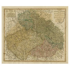
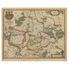
Antique Uncommon Map of Bohemia, Moravia and Silesia, 1699
About the Item
Antique map titled 'B. V. Boleslaviensis in Bohemia, Moravia et Silesia (..).' Detailed uncommon map of the Bohemia, Moravia and Silesia. Source unknown, to be determined.
Artists and Engravers: Heinrich Scherer (1628-1704) was a Professor of Hebrew, Mathematics and Ethics at the University of Dillingen until about 1680. Thereafter he obtained important positions as Official Tutor to the Royal Princes of Mantua and Bavaria. It was during his time in Munich as Tutor to the Princely house of Bavaria that his lifetime’s work as a cartographer received acclaim and recognition. Scherer’s world atlas, the Atlas Novus, first published in Munich between 1702 and 1710 and reissued in a second edition between 1730 and 1737, forms a singularly unusual, almost revolutionary work in terms of the development of European mapmaking at the beginning of the 18th Century.
Condition: Very good, given age. Original folds as issued. General age-related toning and/or occasional minor defects from handling. Please study image carefully.
Date: 1699
Overall size: 40.5 x 27.3 cm.
Image size: 0.001 x 35.5 x 23 cm.
We sell original antique maps to collectors, historians, educators and interior decorators all over the world. Our collection includes a wide range of authentic antique maps from the 16th to the 20th centuries. Buying and collecting antique maps is a tradition that goes back hundreds of years. Antique maps have proved a richly rewarding investment over the past decade, thanks to a growing appreciation of their unique historical appeal. Today the decorative qualities of antique maps are widely recognized by interior designers who appreciate their beauty and design flexibility. Depending on the individual map, presentation, and context, a rare or antique map can be modern, traditional, abstract, figurative, serious or whimsical. We offer a wide range of authentic antique maps for any budget.
- Dimensions:Height: 10.75 in (27.3 cm)Width: 15.95 in (40.5 cm)Depth: 0 in (0.01 mm)
- Materials and Techniques:
- Period:
- Date of Manufacture:1699
- Condition:
- Seller Location:Langweer, NL
- Reference Number:
About the Seller
5.0
Platinum Seller
These expertly vetted sellers are 1stDibs' most experienced sellers and are rated highest by our customers.
Established in 2009
1stDibs seller since 2017
1,929 sales on 1stDibs
Typical response time: <1 hour
- ShippingRetrieving quote...Ships From: Langweer, Netherlands
- Return PolicyA return for this item may be initiated within 14 days of delivery.
More From This SellerView All
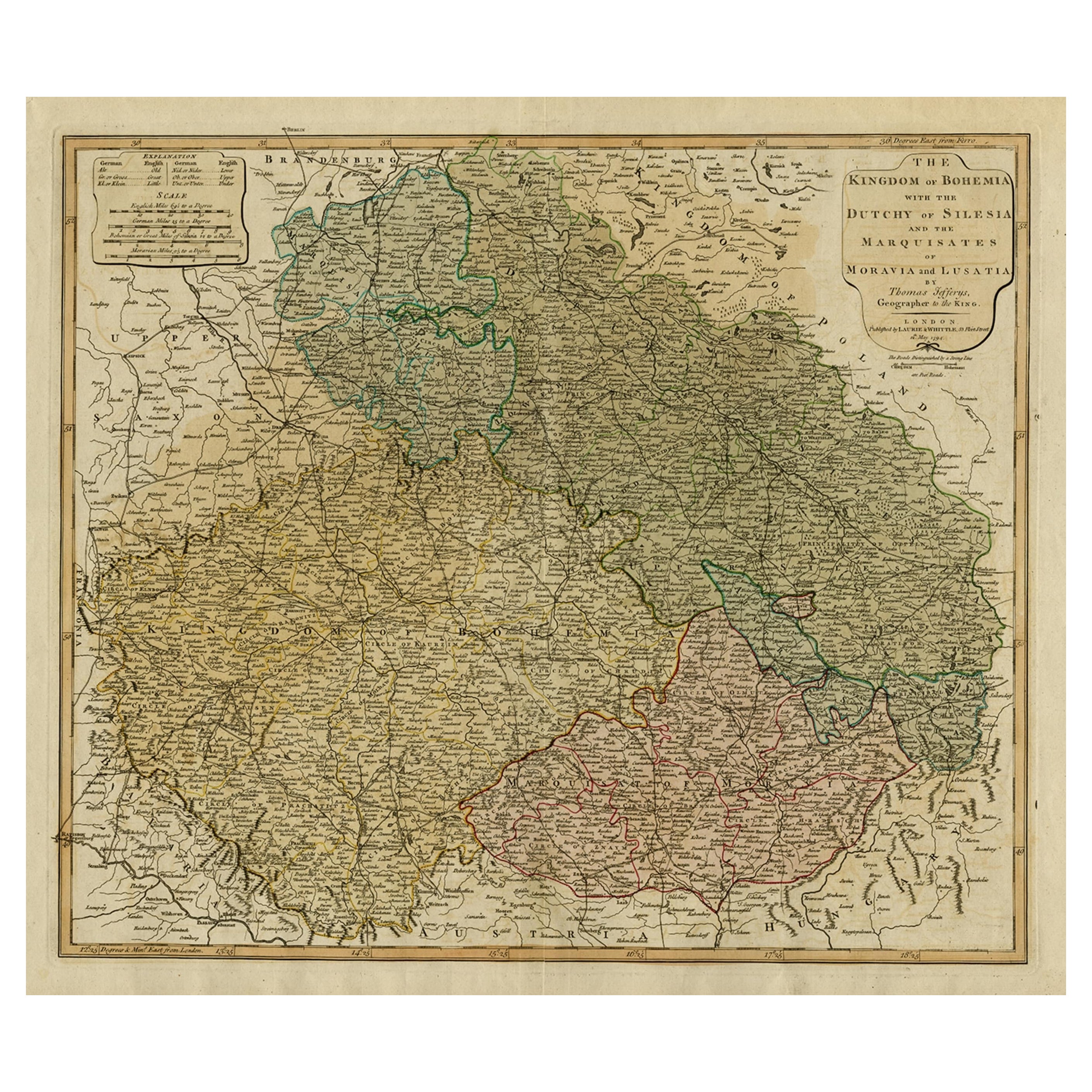
- Original Map of the Kingdom of Bohemia, with Silesia, Moravia and Lusatia, 1804Located in Langweer, NLAntique map titled 'The Kingdom of Bohemia with the Duchy of Silesia and the Marquisates of Moravia and Lusatia.' Map of the Kingdom of Bohemia, with Silesia, Moravia and Lusatia...Category
Antique Early 1800s Maps
MaterialsPaper
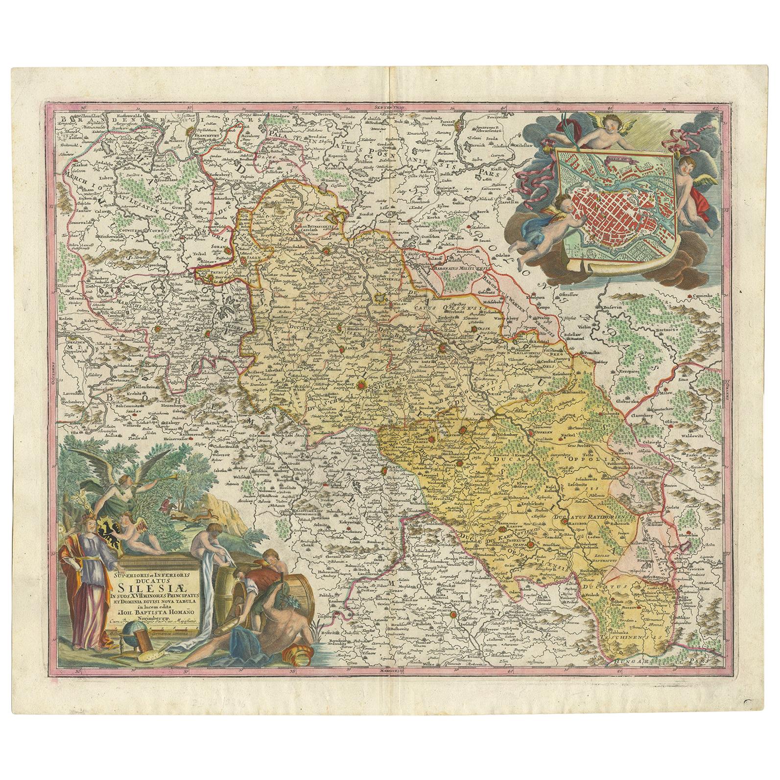
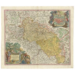
- Antique Map of Silesia, Southwest Poland and a City View of Wroclaw, c 1720By Johann Baptist HomannLocated in Langweer, NLAntique map titled 'Superioris et Inferioris ducatus Silesiae (..)'. Detailed map of Silesia by Johann Baptist Homann. Shows the Southwestern part of Poland between Frankfurt Oder ...Category
Antique Early 18th Century Maps
MaterialsPaper
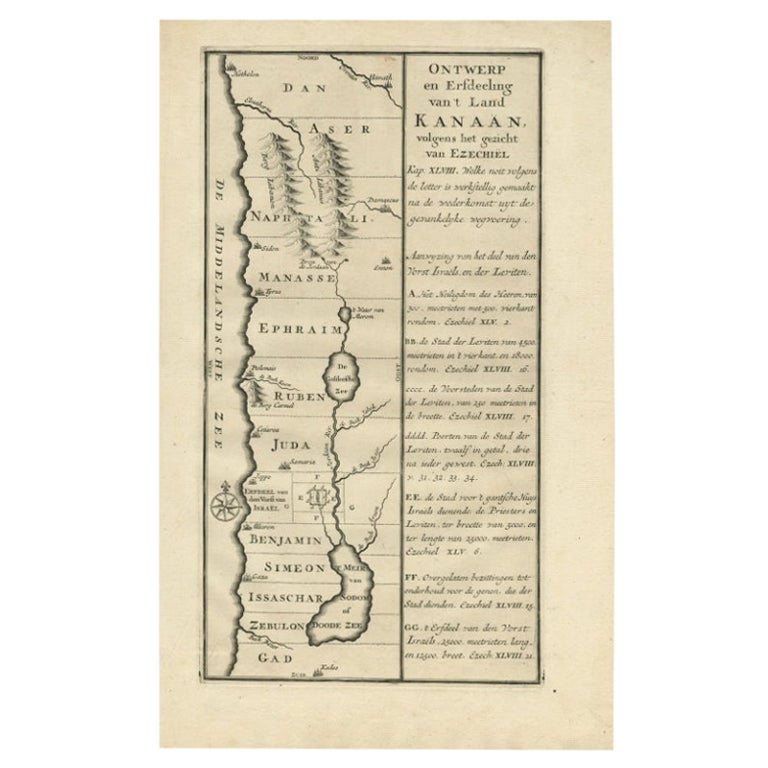
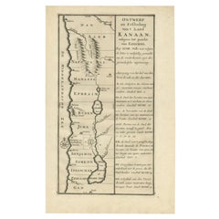
- Antique Uncommon Dutch Map of Ancient Israel, c.1730Located in Langweer, NLAntique map titled 'Ontwerp en Erfdeeling van't Land Kanaan, volgens het gezicht van Ezechiel.' Uncommon map of ancient Israel. This map shows Israel fr...Category
Antique 18th Century Maps
MaterialsPaper
- Antique Map of Lower Silesia of The Famous Mapmaker Blaeu, c.1650Located in Langweer, NLAntique map titled 'Ducatus Silesiae Wolanus'. \ Antique map depicting lower Silesia with the cities of Wolow (Wohlau), Winsko (Winzig), Herrnstadt, Chobie (Koben), Lubin (Lüben), R...Category
Antique 17th Century Maps
MaterialsPaper
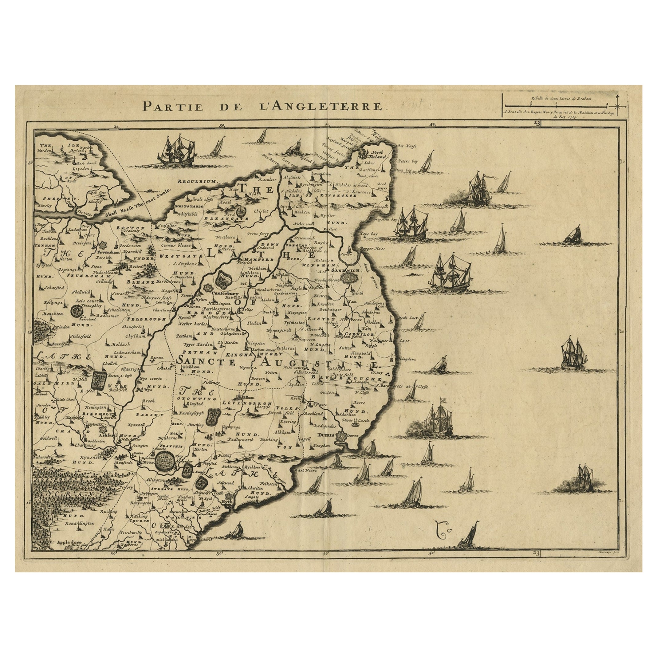
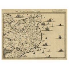
- Uncommon Antique Map of the English Channel Coastline, ca.1709Located in Langweer, NLAntique map titled 'Partie de L'Angleterre' Uncommon map of the English Channel coastline with many boats on the sea. Source unknown, to be determined. Artists and Engravers: Made...Category
Antique Early 1700s Maps
MaterialsPaper
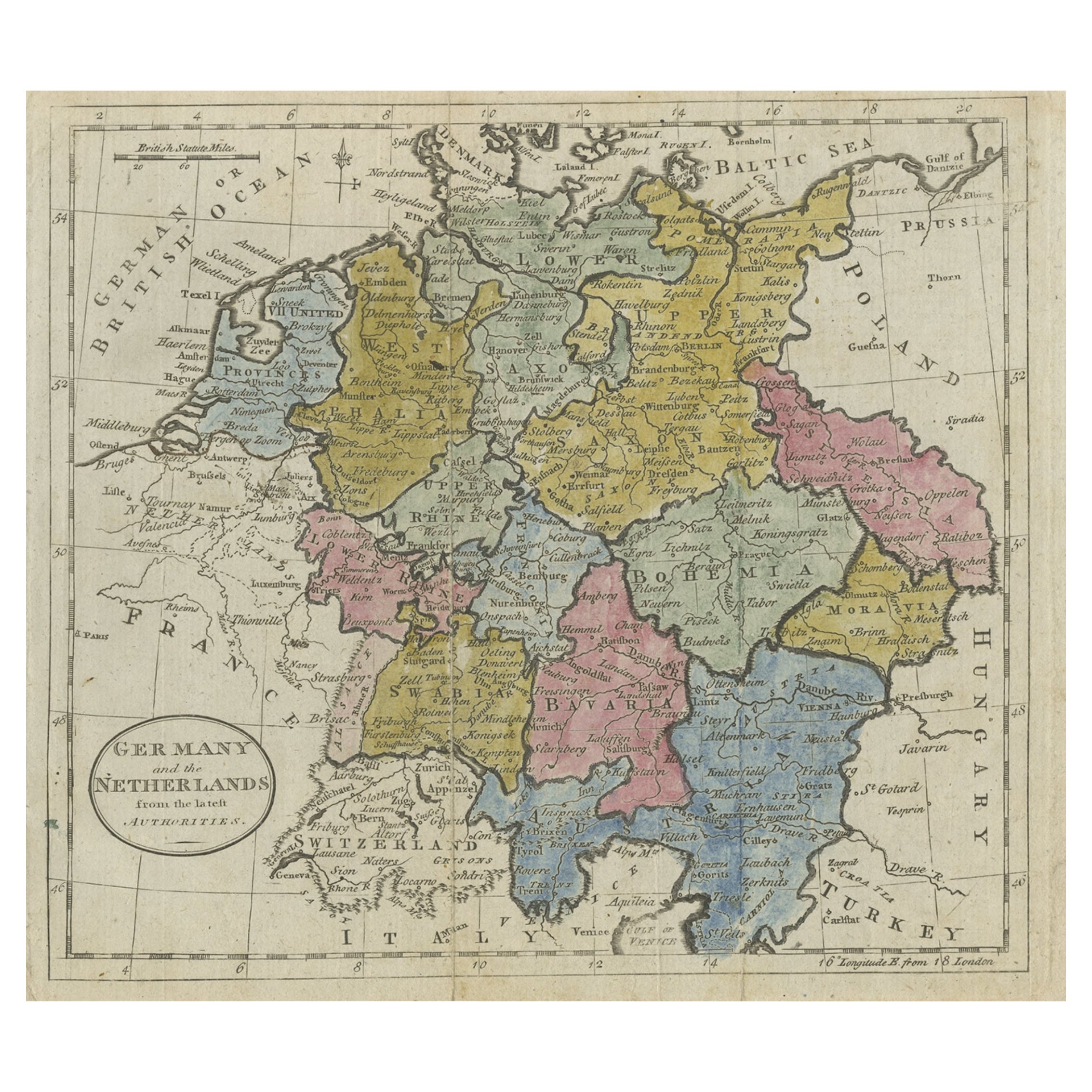
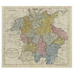
- Antique Map of Germany, the Netherlands, Bohemia, Bavaria and Switzerland, 1785Located in Langweer, NLAntique map titled 'Germany and the Netherlands from the latest authorities'. Depicts Germany, the Netherlands and the surrounding region including Bohemia, Bavaria, and Switzerland....Category
Antique 18th Century Maps
MaterialsPaper
You May Also Like
- Antique Map of Principality of MonacoBy Antonio Vallardi EditoreLocated in Alessandria, PiemonteST/619 - "Old Geographical Atlas of Italy - Topographic map of ex-Principality of Monaco" - ediz Vallardi - Milano - A somewhat special edition ---Category
Antique Late 19th Century Italian Other Prints
MaterialsPaper
- Original Antique Map of Spain and Portugal, circa 1790Located in St Annes, LancashireSuper map of Spain and Portugal Copper plate engraving by A. Bell Published, circa 1790. Unframed.Category
Antique 1790s English Other Maps
MaterialsPaper
- Original Antique Map of Ireland- Tipperary and Waterford. C.1840Located in St Annes, LancashireGreat map of Tipperary and Waterford Steel engraving Drawn under the direction of A.Adlard Published by How and Parsons, C.1840 Unframed.Category
Antique 1840s English Maps
MaterialsPaper
- Original Antique Map of Italy. C.1780Located in St Annes, LancashireGreat map of Italy Copper-plate engraving Published C.1780 Unframed.Category
Antique Early 1800s English Georgian Maps
MaterialsPaper

- Original Antique Map of Asia. C.1780Located in St Annes, LancashireGreat map of Asia Copper-plate engraving Published C.1780 Two small worm holes to right side of map Unframed.Category
Antique Early 1800s English Georgian Maps
MaterialsPaper

- Original Antique Map of India. C.1780Located in St Annes, LancashireGreat map of India Copper-plate engraving Published C.1780 Three small worm holes to right side of map and one bottom left corner Unframed.Category
Antique Early 1800s English Georgian Maps
MaterialsPaper


Recently Viewed
View AllMore Ways To Browse
Unusual Antique Collectables
Antique Prince And
Munich Antiques
17th Century World Map
Antique 17th Century World Map
Antique Bavaria
Hebrew Antique
Heinrich Bavaria
Map Bavaria
Map Of Bavaria
Bohemia Map
Moravia Map
Antique Texas Furniture
Texas Antique Furniture
Cross Decor
Antique Large Maps
Britain Map
American West Antiques