Items Similar to A Rare and Old Trapezoidal Projection of the Ganges and Himalaya Range in India


Want more images or videos?
Request additional images or videos from the seller
1 of 7
A Rare and Old Trapezoidal Projection of the Ganges and Himalaya Range in India
$613.24
$766.5520% Off
£454.45
£568.0620% Off
€512
€64020% Off
CA$837.19
CA$1,046.4920% Off
A$931.34
A$1,164.1820% Off
CHF 488.22
CHF 610.2820% Off
MX$11,380.78
MX$14,225.9820% Off
NOK 6,216.89
NOK 7,771.1220% Off
SEK 5,852.34
SEK 7,315.4320% Off
DKK 3,898.32
DKK 4,872.9020% Off
Shipping
Retrieving quote...The 1stDibs Promise:
Authenticity Guarantee,
Money-Back Guarantee,
24-Hour Cancellation
About the Item
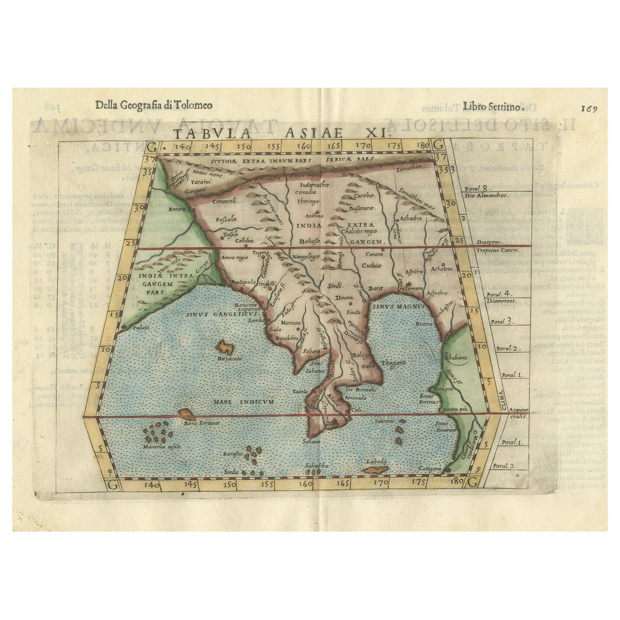
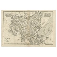
Antique map titled 'Tabula Asiae X'. This Ptolemaic map on a trapezoidal projection is centered on India with recognizable river systems, but completely lacking the sub-continental shape of the landmass. The top of a large unnamed Sri Lanka appears at bottom. Latin text on verso. This map originates from 'Geographia Cl. Ptolemaei Alexandrini (..)'.
- Dimensions:Height: 9.06 in (23 cm)Width: 12.41 in (31.5 cm)Depth: 0.02 in (0.5 mm)
- Materials and Techniques:
- Period:
- Date of Manufacture:circa 1561
- Condition:Very good, given age. General age-related toning. Original folding line, minor wear and foxing. Latin text on verso. Please study images carefully.
- Seller Location:Langweer, NL
- Reference Number:Seller: BG-133371stDibs: LU3054331030662
About the Seller
5.0
Recognized Seller
These prestigious sellers are industry leaders and represent the highest echelon for item quality and design.
Platinum Seller
Premium sellers with a 4.7+ rating and 24-hour response times
Established in 2009
1stDibs seller since 2017
2,502 sales on 1stDibs
Typical response time: <1 hour
- ShippingRetrieving quote...Shipping from: Langweer, Netherlands
- Return Policy
Authenticity Guarantee
In the unlikely event there’s an issue with an item’s authenticity, contact us within 1 year for a full refund. DetailsMoney-Back Guarantee
If your item is not as described, is damaged in transit, or does not arrive, contact us within 7 days for a full refund. Details24-Hour Cancellation
You have a 24-hour grace period in which to reconsider your purchase, with no questions asked.Vetted Professional Sellers
Our world-class sellers must adhere to strict standards for service and quality, maintaining the integrity of our listings.Price-Match Guarantee
If you find that a seller listed the same item for a lower price elsewhere, we’ll match it.Trusted Global Delivery
Our best-in-class carrier network provides specialized shipping options worldwide, including custom delivery.More From This Seller
View AllRare and Very Old Antique Map of South East Asia, Published circa 1574
Located in Langweer, NL
A very fine impression of this map of the Malay Peninsula, Sumatra, Java, with Singapore denoted as 'Cinca Pula'.
Highly distorted and inaccurate map by Girolamo Ruscelli after J...
Category
Antique 16th Century Maps
Materials
Paper

$1,149 Sale Price
20% Off
Free Shipping
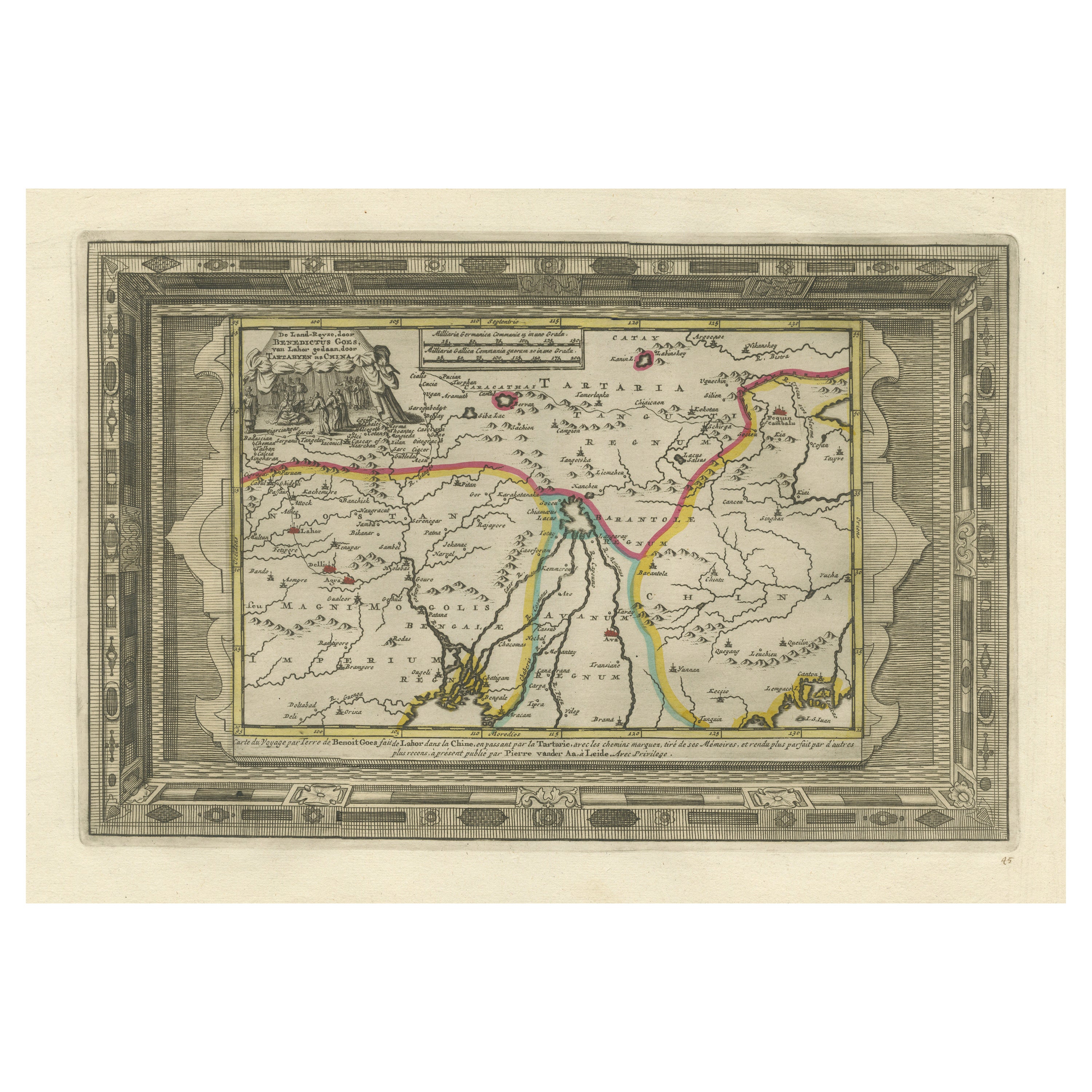
Benedictus Goes’ Route – Antique Map of Tartary to China by Van der Aa, 1714
Located in Langweer, NL
Benedictus Goes’ Route – Antique Map of Tartary to China by Van der Aa, 1714
This fascinating antique map titled De Land-Reyse door Benedictus Goes, van Lahor gedaan, door Tartaryen...
Category
Antique Early 18th Century Dutch Maps
Materials
Paper
$517 Sale Price
20% Off
Antique Map of India as Described It Was before the 5th Century, 1744
Located in Langweer, NL
Antique map titled 'India, as described by all Authors before the fifth Century'. Detailed map of part of India, including Hyrcania, Parthia, Carmania, Gedorossii, Drangiana, Aria, M...
Category
Antique 18th Century Maps
Materials
Paper

$306 Sale Price
20% Off
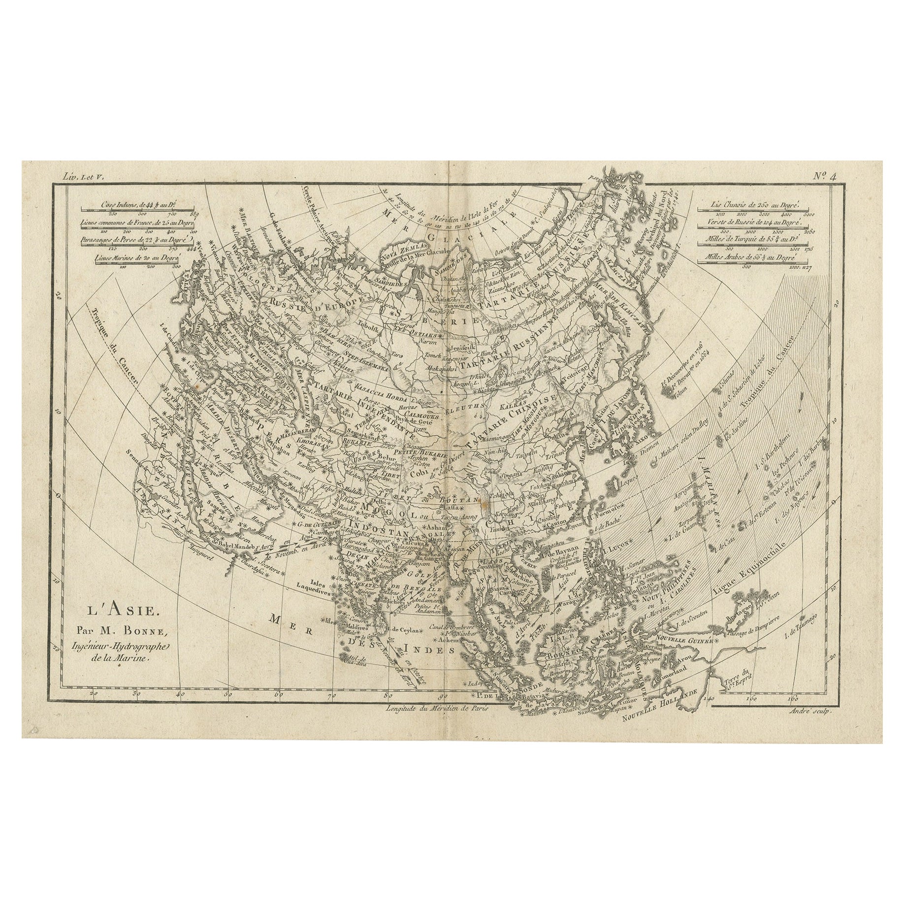
Original Antique Map of Asia
Located in Langweer, NL
Antique map titled 'l'Asie'. Original antique map of Asia. Engraved by André after Bonne. Published circa 1780.
Category
Antique Late 18th Century Maps
Materials
Paper
$277 Sale Price
20% Off
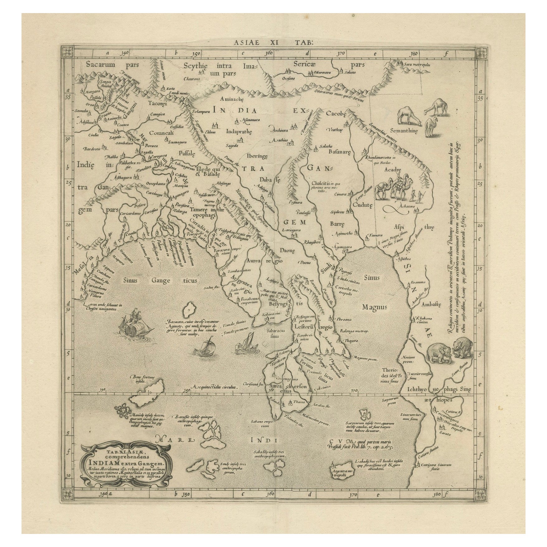
Original Antique Ptolemaic Map of the Region of Thailand and Malaysia
Located in Langweer, NL
Antique map titled 'Tabula Asiae XI'. Based on the interpretations of Solinus and Munster, this Ptolemaic map covers the region roughly of Thailand and Malaysia. An oddly shaped (Mal...
Category
Antique 16th Century Maps
Materials
Paper

$546 Sale Price
20% Off
1698 Mercator Ptolemaic Map of Asia East of the Ganges
Located in Langweer, NL
**Catalogue Description:**
**Title:** Tab. XI. Asiae, comprehendens Indiam extra Gangem.
**Description:**
This is an exquisite Ptolemaic map depicting Asia east of the Ganges, ti...
Category
Antique 1680s Maps
Materials
Paper

$900 Sale Price
20% Off
You May Also Like
Antique 1803 Italian Map of Asia Including China Indoneseia India
Located in Amsterdam, Noord Holland
Antique 1803 Italian Map of Asia Including China Indoneseia India
Very nice map of Asia. 1803.
Additional information:
Type: Map
Country of Manufacturing: Europe
Period: 19th centu...
Category
Antique 19th Century European Maps
Materials
Paper

$584 Sale Price
20% Off
Antique French Map of Asia Including China Indoneseia India, 1783
Located in Amsterdam, Noord Holland
Very nice map of Asia. 1783 Dedie au Roy.
Additional information:
Country of Manufacturing: Europe
Period: 18th century Qing (1661 - 1912)
Condition: Overall Condition B (Good Used)...
Category
Antique 18th Century European Maps
Materials
Paper

$648 Sale Price
20% Off
1718 Ides & Witsen Map "Route D'amsterdam a Moscow Et De La Ispahan Et Gamron
Located in Norton, MA
1718 Ides & Witsen map, entitled
"Route D'Amsterdam A Moscow Et De La Ispahan Et Gamron,"
Ric.b005
Subject: Eastern Europe and Central Asia
Period: 1718 (published)
Publicati...
Category
Antique Early 18th Century Dutch Maps
Materials
Paper

West Coast of Africa, Guinea & Sierra Leone: An 18th Century Map by Bellin
By Jacques-Nicolas Bellin
Located in Alamo, CA
Jacques Bellin's copper-plate map entitled "Partie de la Coste de Guinee Dupuis la Riviere de Sierra Leona Jusquau Cap das Palmas", depicting the coast of Guinea and Sierra Leone in ...
Category
Antique Mid-18th Century French Maps
Materials
Paper

1627 Hendrik Hondius Map Entitled "Vltoniae Orientalis Pars, " Ric.a009
Located in Norton, MA
1627 Hendrik Hondius map entitled
"Vltoniae orientalis pars,"
Ric.a009
Title:
Vltoniae orientalis : pars
Title (alt.) :
Ultoniae orientalis pars
Creator:
Mercator, Gerh...
Category
Antique 17th Century Dutch Maps
Materials
Paper

Ancient National Atlas of France with Marengo
Located in Alessandria, Piemonte
Ancient National Atlas of France with the department of Marengo: a rare French etching dated 1806.
ST/178.
Category
Antique Early 19th Century French Other Prints
Materials
Paper

More Ways To Browse
Patagonia Map
Shepherd And Hedger
Vignola Furniture
Washington Dc Map
Antique Map Of Cornwall
Coronelli Globe
Vintage Bartholomew Maps
Antique Alabama Map
Cape Cod Map
Goa France
Antique Planisphere
Charlotte Reine
Dutch Malacca
Gabon Antique Map
J And C Bavaria
Map Of Barbados
Montreal Map
Antique Furniture Toledo Ohio