Items Similar to Rhine Splendor: Antique Map of the Lower Rhine Region, circa 1680


Want more images or videos?
Request additional images or videos from the seller
1 of 5
Rhine Splendor: Antique Map of the Lower Rhine Region, circa 1680
$920.17
$1,150.2220% Off
£685.01
£856.2620% Off
€768
€96020% Off
CA$1,260.41
CA$1,575.5120% Off
A$1,401.85
A$1,752.3120% Off
CHF 732
CHF 91520% Off
MX$17,059.02
MX$21,323.7720% Off
NOK 9,348.79
NOK 11,685.9820% Off
SEK 8,767.51
SEK 10,959.3920% Off
DKK 5,846.52
DKK 7,308.1420% Off
Shipping
Retrieving quote...The 1stDibs Promise:
Authenticity Guarantee,
Money-Back Guarantee,
24-Hour Cancellation
About the Item
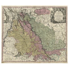
The antique map titled 'Novissima et Accuratissima Archiepiscopatus et Electoratus Coloniensis Ducatuum Iuliancensis et Montensis et Meursiae Comitatus' is a handsome and detailed map of the lower Rhine region in Germany, with a focus on the city of Cologne. Here are the key details:
1. **Geographic Coverage**:
- The map provides a comprehensive view of the lower Rhine region in Germany.
- It covers the territories of the Archbishopric and Electorate of Cologne, the Duchy of Julich (Jülich), the Duchy of Berg (Montensis), and the County of Meurs (Meursiae).
2. **Cartographic Details**:
- The map is fully engraved with precise details, including the locations of towns, political boundaries, rivers, and forests.
- It offers a valuable historical representation of the geography of the region during the period in which it was created.
3. **Cartouches**:
- The map is embellished with two cartouches:
- The title cartouche features putti (cherubic figures) and coats of arms, adding decorative elements to the map.
- Below, there is another cartouche that includes a scale and more putti, enhancing the map's aesthetic appeal.
4. **Attribution**:
- The map is attributed to 'Frederick de Wit,' who likely played a role in its production. However, the map was made after the work of an anonymous artist.
5. **Source**:
- The exact source of this map, such as the original publication or source material used, may require further historical research to determine.
Overall, this antique map serves as a valuable historical document that provides insights into the lower Rhine region of Germany during the period it represents. Its detailed cartography and decorative elements make it a notable example of cartographic artistry from the era in which it was created.Frederik/Frederick de Wit (Amsterdam 1630-1706), was a famous engraver and publisher in Amsterdam. He acquired many of the printing plates of Blaeu and Janssonius when it came to auction. His map were very popular because of the quality of the engravings and the beautiful colouring. After his death his work was re-issued by Pieter Mortier and Covens & Mortier.
- Dimensions:Height: 21.03 in (53.4 cm)Width: 24.22 in (61.5 cm)Depth: 0 in (0.02 mm)
- Materials and Techniques:
- Period:1680-1689
- Date of Manufacture:circa 1680
- Condition:Good, given age. Minor paper separation bottom middle fold in margin; backed. Vertical crease left and right of middle fold. A few spots in the margins. Original middle fold as issued. General age-related toning and/or occasional minor defects.
- Seller Location:Langweer, NL
- Reference Number:Seller: PCT-580301stDibs: LU3054327310332
About the Seller
5.0
Recognized Seller
These prestigious sellers are industry leaders and represent the highest echelon for item quality and design.
Platinum Seller
Premium sellers with a 4.7+ rating and 24-hour response times
Established in 2009
1stDibs seller since 2017
2,510 sales on 1stDibs
Typical response time: <1 hour
- ShippingRetrieving quote...Shipping from: Langweer, Netherlands
- Return Policy
Authenticity Guarantee
In the unlikely event there’s an issue with an item’s authenticity, contact us within 1 year for a full refund. DetailsMoney-Back Guarantee
If your item is not as described, is damaged in transit, or does not arrive, contact us within 7 days for a full refund. Details24-Hour Cancellation
You have a 24-hour grace period in which to reconsider your purchase, with no questions asked.Vetted Professional Sellers
Our world-class sellers must adhere to strict standards for service and quality, maintaining the integrity of our listings.Price-Match Guarantee
If you find that a seller listed the same item for a lower price elsewhere, we’ll match it.Trusted Global Delivery
Our best-in-class carrier network provides specialized shipping options worldwide, including custom delivery.More From This Seller
View AllDetailed Antique Map of the Lower Rhine region, Germany
Located in Langweer, NL
Antique map titled 'S.R.I. Circulus Rhanus Inferior sive Electorum Rheni (..)'. Detailed map of the Lower Rhine region, Germany. The title cartouche in the upper left quadrant featur...
Category
Antique Mid-18th Century Maps
Materials
Paper

$431 Sale Price
20% Off
Antique Map of the Rhine centered on Cologne, Germany
Located in Langweer, NL
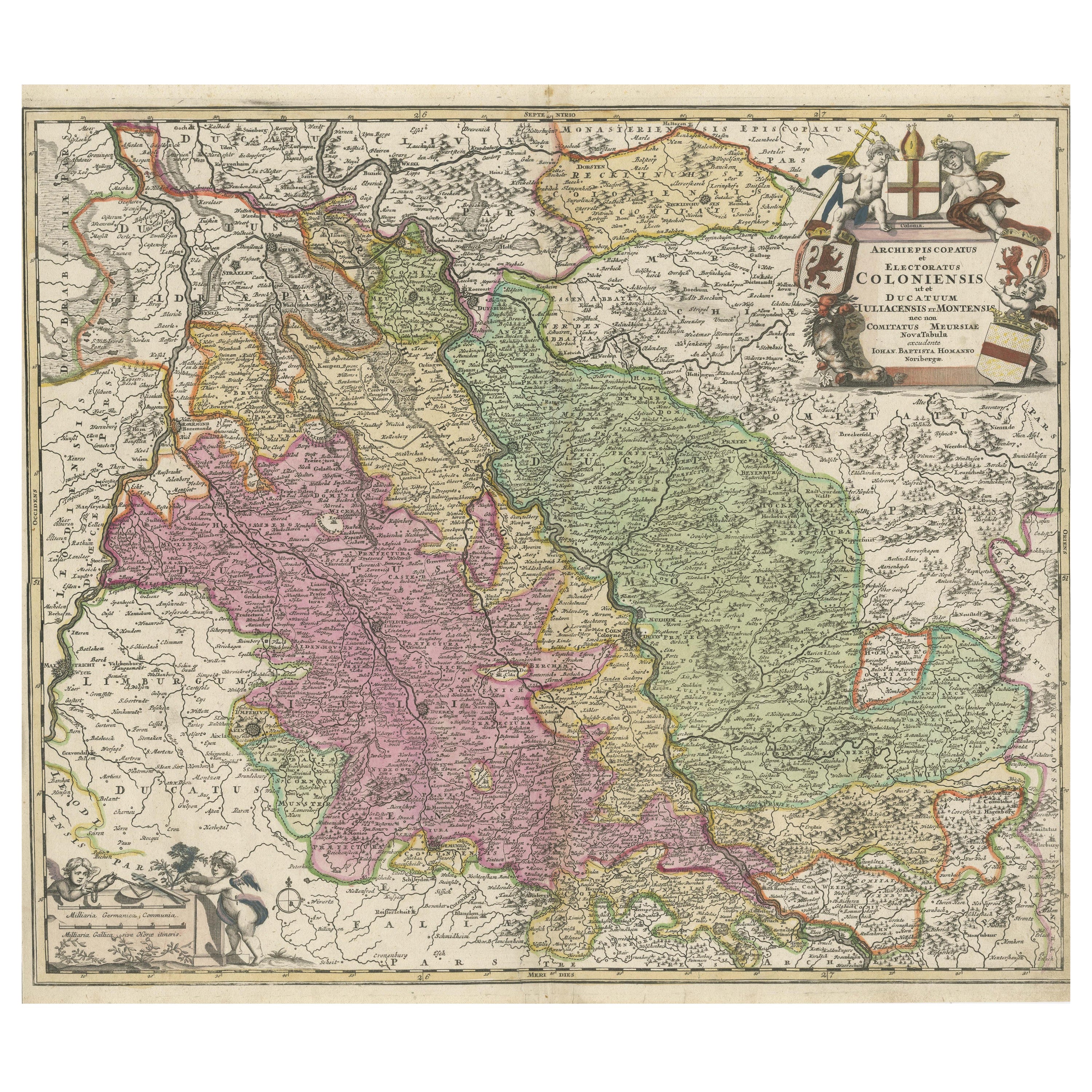
Antique map titled 'Archiepsiscopatus et Electoratus Coloniensis (..)'. Original antique map of the Rhine river, centered on Cologne, Germany. The Rhine River cuts across this map fr...
Category
Antique Early 18th Century Maps
Materials
Paper

$527 Sale Price
20% Off
Antique Map of Southern Germany by F. de Wit, circa 1680
Located in Langweer, NL
This antique map depicts a portion of southern Germany that included the historic regions of Bavaria, the Palatinate, Prussia-Brandenburg, the Rhineland and Saxony. Regensberg, Freis...
Category
Antique Late 17th Century Maps
Materials
Paper

$666 Sale Price
20% Off
Antique Map of the Saxony Region 'Germany' by F. de Wit, circa 1680
Located in Langweer, NL
A detailed map of a region in eastern Germany. Cartouches depict coat of arms surrounded by cherubs. The map is fully engraved with towns, political boundaries, rivers and forests. P...
Category
Antique Late 17th Century Dutch Maps
Materials
Paper

Antique Map of both sides of the Central Rhine River, Germany
Located in Langweer, NL
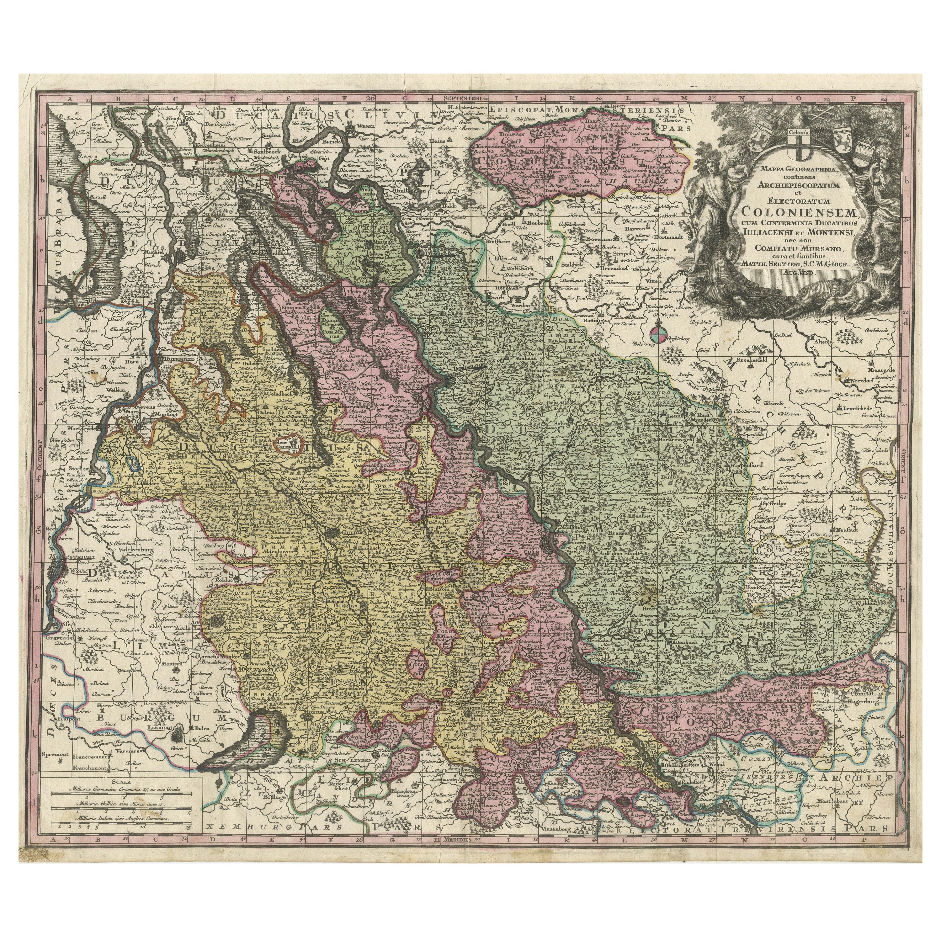
Antique map titled 'Mappa Geographica continens Archiepiscopatum et Electoratum Coloniensem (..)'. Decorative map of region on either side of the Central Rhine River, showing Dusseld...
Category
Antique Mid-18th Century Maps
Materials
Paper
$517 Sale Price
20% Off
Antique Map of Belgium and Surroundings, 1692
Located in Langweer, NL
Antique map titled 'Provincie Meridionali de Paesi Bassi Intese sotto nome di Fiandra overo Li Paesi Bassi Cattolici con li confini di Francia di Allemagna et di Hollanda'. Uncommon map of Belgium...
Category
Antique 17th Century Maps
Materials
Paper

$407 Sale Price
20% Off
You May Also Like
17th Century Hand-Colored Map of a Region in West Germany by Janssonius
By Johannes Janssonius
Located in Alamo, CA
This attractive highly detailed 17th century original hand-colored map is entitled "Archiepiscopatus Maghdeburgensis et Anhaltinus Ducatus cum terris adjacentibus". It was published ...
Category
Antique Mid-17th Century Dutch Maps
Materials
Paper

17th Century Hand Colored Map of the Liege Region in Belgium by Visscher
By Nicolaes Visscher II
Located in Alamo, CA
An original 17th century map entitled "Leodiensis Episcopatus in omnes Subjacentes Provincias distincté divisusVisscher, Leodiensis Episcopatus" by Nicolaes Visscher II, published in Amsterdam in 1688. The map is centered on Liege, Belgium, includes the area between Antwerp, Turnhout, Roermond, Cologne, Trier and Dinant.
This attractive map is presented in a cream-colored mat measuring 30" wide x 27.5" high. There is a central fold, as issued. There is minimal spotting in the upper margin and a tiny spot in the right lower margin, which are under the mat. The map is otherwise in excellent condition.
The Visscher family were one of the great cartographic families of the 17th century. Begun by Claes Jansz Visscher...
Category
Antique Late 17th Century Dutch Maps
Materials
Paper

Prussia, Poland, N. Germany, Etc: A Hand-colored 17th Century Map by Janssonius
By Johannes Janssonius
Located in Alamo, CA
This is an attractive hand-colored copperplate engraved 17th century map of Prussia entitled "Prussia Accurate Descripta a Gasparo Henneberg Erlichensi", published in Amsterdam by Joannes Janssonius in 1664. This very detailed map from the golden age of Dutch cartography includes present-day Poland, Latvia, Lithuania, Estonia and portions of Germany. This highly detailed map is embellished by three ornate pink, red, mint green and gold...
Category
Antique Mid-17th Century Dutch Maps
Materials
Paper

18th Century Hand-Colored Homann Map of Germany, Including Frankfurt and Berlin
By Johann Baptist Homann
Located in Alamo, CA
An 18th century hand-colored map entitled "Tabula Marchionatus Brandenburgici et Ducatus Pomeraniae quae sunt Pars Septentrionalis Circuli Saxoniae Superioris" by Johann Baptist Homa...
Category
Antique Early 18th Century German Maps
Materials
Paper

1752 Vaugoundy Map of Flanders : Belgium, France, and the Netherlands, Ric.a002
Located in Norton, MA
Large Vaugoundy Map of Flanders:
Belgium, France, and the Netherlands
Colored -1752
Ric.a002
Description: This is a 1752 Didier Robert de Vaugondy map of Flanders. The map de...
Category
Antique 17th Century Unknown Maps
Materials
Paper

1643 Willem&Joan Blaeu Map NW Flanders "Flandriae Teutonicae Pars Prientalior
Located in Norton, MA
1643 Willem and Joan Blaeu map of northwest Flanders, entitled
"Flandriae Teutonicae Pars Prientalior,"
Ric0012
" Authentic" - Map of the northwest Fl...
Category
Antique 17th Century Dutch Maps
Materials
Paper

More Ways To Browse
Ptolemy Map
Map Of Jerusalem
1820 World Map
Cyprus Antique Maps
Antique Ecuador
Antique Map Of Thailand
Antique Mississippi Map
Antique Ohio Maps
Burgundy Map
John Speed Maps
Antique Map Of Turkish Empire
Antique Portuguese Scales
Canadian Atlas Furniture
Prussia Map
Afghanistan Map
Malabar Map
Antique Compass Made In France
Antique Maps Dublin