Early Victorian Maps
to
11
11
77
35
18
13
6
5
4
4
4
3
1
1
11
7
6
1
1
1
11
8
3
3
11
11
11
1
1
Style: Early Victorian
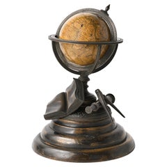
Miniature Terrestrial Globe Newton & Son London, Post 1833, Ante 1858
Located in Milano, IT
Miniature Terrestrial Globe
Newton & Son
London, post 1833, ante 1858
Paper, papier-mâché, bronze and wood
It measures: sphere diameter 2.95 in (7.6 cm); diameter of the wooden base 6.02 in (15.3 cm); height 8.36 in (21.24 cm).
Weight: 2,067 lb.
State of conservation: the globe still bears its original paint, but has various small gaps, abrasions and stains on the surface.
The globe is hinged with two pins at the meridian circle, which is in turn inserted perpendicular to the horizon circle; this is supported by four semi-arches connected at the bottom by a small goblet-shaped foot, resting on a wooden bell-shaped base.
Apart from the wooden base, the entire support structure is made of bronze; on the foot there are the scale reproductions of a compass, a telescope and an open book.
The sphere is made of papier-mâché and is covered with twelve printed paper gores.
In the North Pacific Ocean the globe bears a cartouche with the inscription (about 30% of the writing is illegible, but the missing parts can be easily integrated based on the rest):
NEWTON’S
New & Improved
TERRESTRIAL
Globe
Published by Newton & Son
66 Chancery Lane
LONDON
On the globe, much of central Africa is empty and the great lakes Tanganyika and Victoria are not marked (Europeans would begin to explore the area after 1858). Canada is called "British Territory" and Alaska "Russian Territory" (it would become part of the United States in 1867). Australia already bears its modern name (until 1829 it had been called New Holland) and its coasts are completely designed; Tasmania is listed as an island (Matthew Flinders circumnavigated it in 1798). The routes of Cook's various voyages are plotted; both the route followed by Biscoe in 1831 and the "Land of Enderby" which he discovered on the coast of Antarctica, south of Africa, are marked.
Bibliography
P. Van der Krogt, Old Globes...
Category
1840s English Antique Early Victorian Maps
Materials
Bronze
Antique Lithography Map, Western Russia, English, Framed, Cartography, Victorian
Located in Hele, Devon, GB
This is an antique lithography map of Western Russia. An English, framed atlas engraving of cartographic interest by John Rapkin, dating to the early Victorian period and later, circ...
Category
Mid-19th Century British Antique Early Victorian Maps
Materials
Wood
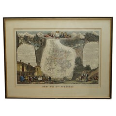
Fine French Antique 1856 Hand Watercolour Map of Dept Des Hautes Pyrenees
Located in West Sussex, Pulborough
We are delighted to offer for sale this stunning 1856 hand watercolour map of the Austrian Alps titled Dept Des Hautes Pyrenees taken from the Atlas Nat...
Category
1850s French Antique Early Victorian Maps
Materials
Paper
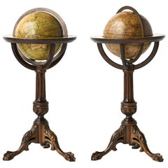
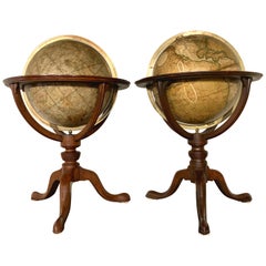
Pair of Miniature Globes Lane’s on Tripod Bases, London post 1833, ante 1858
By Lane's
Located in Milano, IT
Pair of miniature globes
Lane’s, London, post 1833, ante 1858
Papier-mâché, wood and paper
They measure:
Height 9.44 in (24 cm);
Sphere diameter 2.75 in (7 cm);
Diameter of t...
Category
1840s English Antique Early Victorian Maps
Materials
Paper, Wood
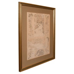
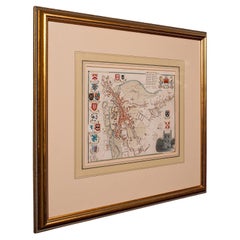
Antique Lithography Map, Coastal England, Framed Cartography Interest, Victorian
Located in Hele, Devon, GB
This is an antique lithography map of Coastal England. A Scottish, framed town engraving of cartographic interest, dating to the early Victorian period and later.
Superb lithograph...
Category
Mid-19th Century British Antique Early Victorian Maps
Materials
Glass, Wood
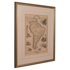
Antique Lithography Map, South America, English, Framed, Cartography, Victorian
Located in Hele, Devon, GB
This is an antique lithography map of South America. An English, framed atlas engraving of cartographic interest by John Rapkin , dating to the early Victorian period and later, circ...
Category
Mid-19th Century British Antique Early Victorian Maps
Materials
Wood
Antique Lithography Map, West Africa, English, Framed, Cartography, Victorian
Located in Hele, Devon, GB
This is an antique lithography map of Western Africa. An English, framed atlas engraving of cartographic interest by John Rapkin, dating to the early Victorian period and later, circ...
Category
Mid-19th Century British Antique Early Victorian Maps
Materials
Wood
Antique Lithography Map, Black Sea, English, Framed, Cartography, Victorian
Located in Hele, Devon, GB
This is an antique lithography map of the Black Sea region. An English, framed atlas engraving of cartographic interest by John Rapkin, dating to the early Victorian period and later...
Category
Mid-19th Century British Antique Early Victorian Maps
Materials
Wood
Map Hanging Wall County of Devon C&J Greenwood 1827 Exeter Cathedral Lundy Isle
Located in BUNGAY, SUFFOLK
C & J GREENWOOD MAP OF THE COUNTY OF DEVON, FROM AN ORIGINAL SURVEY, PUBLISHED 1827, WITH ENGRAVING OF EXETER CATHEDRAL AND MAP OF LUNDY INSET, 6ft 2 ...
Category
1820s English Antique Early Victorian Maps
Materials
Paper
Fine Antique 1856 Hand Watercolour Map of Dept Des Hautes Alpes by Levasseur's
Located in West Sussex, Pulborough
We are delighted to offer for sale this stunning 1856 hand watercolour map of the Austrian Alps titled Dept Des Hautes Alpes taken from the Atlas National...
Category
1850s French Antique Early Victorian Maps
Materials
Paper
Beautiful Colour French Antique 1856 Hand Watercolour Map of Dept Des La Corse
Located in West Sussex, Pulborough
We are delighted to offer for sale this stunning 1856 hand watercolour map of the Austrian Alps titled Dept Des La Course taken from the Atlas National ...
Category
1850s French Antique Early Victorian Maps
Materials
Paper
Related Items
Chinoiserie Grand Piano From Rogers and Sons London
Located in Berlin, DE
Chinoiserie Grand Piano by Rogers and Sons London
The grand piano was manufactured according to the device number 1930.
The grand piano was sold in 1932 by Harrods London to a lady ...
Category
1930s Vintage Early Victorian Maps
Materials
Wood
Pair of 19th Century English J & W Cary Celestial/Terrestrial Table Model Globes
Located in Milford, NH
A fine assembled pair of 12-inch English table model globes on stands manufactured by J & W. Cary, the left globe with cartouche labeled “The New Celestial Globe, on which are correc...
Category
Early 19th Century English Antique Early Victorian Maps
Materials
Brass
$18,900 / set
H 25 in Dm 16.5 in
Antique Map of Russia by Tyrer, 1821
Located in Langweer, NL
Antique map titled 'Russia'. Beautiful antique map of Russia engraved by Tyrer. Artists and Engravers: Published by J. Souter, London.
Artist...
Category
19th Century Antique Early Victorian Maps
Materials
Paper
Antique Hammond's 6-Inch Terrestrial Globe on Stand
Located in Philadelphia, PA
Offered here for your consideration is, A fine antique 6-inch terrestrial globe.
Additional Details:
By C.S. Hammond & Co.
The globe likely dates from 1927 to 1930 due to the ...
Category
20th Century Unknown Early Victorian Maps
Materials
Wood, Paper
Antique World Globe From Fleet Street London 1923 on Wooden Stand
Located in Reading, Berkshire
Antique Terrestrial Geographia of Fleet Street London 12"inch World Globe on handcrafted Wooden Three Legged Base 1923
Made 55 Fleet Street, London
Beautiful desktop globe, sho...
Category
1920s British Vintage Early Victorian Maps
Materials
Wood, Paper
$1,331 Sale Price
25% Off
H 18.51 in Dm 11.82 in
Antique Map of Venezuela by Montanus, 1671
Located in Langweer, NL
Antique map titled 'Venezuela cum parte Australi Novae Andalusiae'. The map extends from Coquibocoa to the Orinoque River, centered on Bariquicemento and Cape de Curiacao. Large cart...
Category
Mid-17th Century English Antique Early Victorian Maps
Materials
Paper
Antique Map of South America by Johnston '1909'
Located in Langweer, NL
Antique map titled 'South America, Southern Sheet'. Depicting Chile, Argentina, Brazil, Patagonia, the Falkland Island and more. With inset maps of Valparaiso, Rio de Janeiro and Bue...
Category
Early 20th Century Early Victorian Maps
Materials
Paper
$239 Sale Price
20% Off
H 19.49 in W 24.41 in D 0.02 in
19th Century German Miniature Pocket Terrestrial Globe
Located in Essex, MA
A miniature 19th century 3.5 inch diameter pocket terrestrial globe by C. Abel-Klinger, Nuremberg, Germany, in English for the English speaking markets. Signed with cartouche reading...
Category
1880s German Antique Early Victorian Maps
Materials
Brass
Old Original Antique Map of Western Canada, 1882
Located in Langweer, NL
Antique map titled 'Dominion of Canada'.
Old map of Western Canada. This map originates from 'The Royal Atlas of Modern Geography, Exhibiting, in a ...
Category
1880s Antique Early Victorian Maps
Materials
Paper
Large and Extremely Rare Terrestrial Globe by Newton
By Newton Globes - Planer & Newton
Located in Lymington, Hampshire
A large and extremely rare 24-inch terrestrial globe by Newton
Our most magnificent and rare globes were a pair of 24-inch Newton globes.
These too were updated in 1852 (terre...
Category
Mid-19th Century English Antique Early Victorian Maps
Materials
Mahogany
Pair of Trompe L'oeil Miniature Chests
Located in West Palm Beach, FL
Very sweet pair of small trompe l'oeil chests with art work on all four sides.
Category
20th Century Early Victorian Maps
Materials
Wood
7 Vol. Set- Charles Merivale, A History Of The Romans Under The Empire, 1858
Located in Bridgeport, CT
London, Longman, Brown, Green, Longmans, & Roberts, various publishing dates. Bound in tan leather with red and brown with gilt spines. Marbelized end papers. All with bookplates ins...
Category
19th Century English Antique Early Victorian Maps
Materials
Leather, Paper
$1,320 / set
H 8.75 in W 6 in D 1.75 in
Previously Available Items
Antique Collegiate Map, Cambridge, English, Framed Cartography, Victorian, 1838
Located in Hele, Devon, GB
This is an antique collegiate map of Cambridge. An English, framed coloured lithograph of cartographic interest by Thomas Moule, dating to the early Victorian period, circa 1838.
T...
Category
Early 19th Century British Antique Early Victorian Maps
Materials
Glass, Wood, Paper
H 17.33 in W 19.3 in D 0.99 in
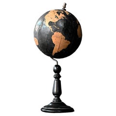
Rare 19th Century Philips Graphic Globe
Located in London, GB
Rare 19th century Philips graphic globe.
Dated to the mid-19th century this geometric paper Philips graphic globe stands on an ebonised turned base. Stamped, Philips graphic globe land areas in white, George Philips and sons ltd 32 fleet St. A rare example in this model and in overall presentable condition considering its age and use.
Size in inches: H 9” x W 4” x D 4”
Origin: United Kingdom
Material: wood and paper
Date: mid-19th century
Completely solid in structure and form without any breaks. Detail loss across the printed paper surface as shown. We sell antique...
Category
1850s British Antique Early Victorian Maps
Materials
Wood
Large Original Antique Street Map of London, 1861
Located in St Annes, Lancashire
Wonderful street map of London showing the area between Kensington in the west and Limehouse in the east.
It is compiled and engraved by Edward Weller, London, 1861.
It compr...
Category
1860s English Antique Early Victorian Maps
Materials
Paper
Early Victorian maps for sale on 1stDibs.
Find a broad range of unique Early Victorian maps for sale on 1stDibs. Many of these items were first offered in the 19th Century, but contemporary artisans have continued to produce works inspired by this style. If you’re looking to add vintage maps created in this style to your space, the works available on 1stDibs include more furniture and collectibles, wall decorations and other home furnishings, frequently crafted with paper, wood and other materials. If you’re shopping for used Early Victorian maps made in a specific country, there are Europe, United Kingdom, and England pieces for sale on 1stDibs. While there are many designers and brands associated with original maps, popular names associated with this style include Lane's, and Newton and Son. It’s true that these talented designers have at times inspired knockoffs, but our experienced specialists have partnered with only top vetted sellers to offer authentic pieces that come with a buyer protection guarantee. Prices for maps differ depending upon multiple factors, including designer, materials, construction methods, condition and provenance. On 1stDibs, the price for these items starts at $971 and tops out at $12,842 while the average work can sell for $1,726.
Recently Viewed
View AllMore Ways To Browse
Bavarian Porcelain Vases
Beer Tankard
Bjorn L
Black Cabinet With Flowers And Birds
Black Tansu Chest
Blue Morpho
Blue Opaline Crystal Vases
Bow Front Buffet
Boy And Girl Statues
Brass Donkey
Brass Hound
Bread Oven
Bronze Atlas Sculpture
Bronze Door Stop
Bronze Shakespeare Sculpture
Buddha Bell
Bull Terrier
Butlers Chest
