Items Similar to 18th Century Hand-Colored Homann Map of Germany, Including Frankfurt and Berlin


Want more images or videos?
Request additional images or videos from the seller
1 of 6
18th Century Hand-Colored Homann Map of Germany, Including Frankfurt and Berlin
$775
£588.48
€672.97
CA$1,082.79
A$1,204.30
CHF 628.85
MX$14,655
NOK 8,031.32
SEK 7,531.96
DKK 5,022.60
Shipping
Retrieving quote...The 1stDibs Promise:
Authenticity Guarantee,
Money-Back Guarantee,
24-Hour Cancellation
About the Item
An 18th century hand-colored map entitled "Tabula Marchionatus Brandenburgici et Ducatus Pomeraniae quae sunt Pars Septentrionalis Circuli Saxoniae Superioris" by Johann Baptist Homann (1663-1724), published in Nuremberg, Germany initially in 1720 in his 'Grosser Atlas' and again in 1728, shortly after his death, in Homann Heirs’ 'Maior Atlas Scholasticus'. The map depicts the Brandenburg and Pomerania regions of Germany, including the cities of Frankfurt, Brandenburg and Berlin. It also includes parts of Denmark and much of Poland. The title cartouche in the upper right quadrant features cherubs and armorial shields for both Brandenburg and Pomerania. There is a legend in the lower right quadrant.
There is a central vertical fold as issued. There is a small closed tear in the right margin, a small area of paper loss in the lower margin on the right, a small faint area of discoloration in the right upper periphery and mild discoloration in the lower margin. The map is otherwise in very good condition.
Johann Baptist Homann (1663-1724) was a mapmaker who founded a respected and prolific publishing company, which continued long after his death as Homann Heirs. Homann lived his entire life in Bavaria, particularly in Nuremberg. Initially, Johann trained to become a priest before converting to Protestantism and working as a notary. In 1702, Johann founded a publishing house that specialized in engravings. The firm flourished, becoming the leading map publisher in Germany and an important entity in the European map market. In 1715, Johann was named Imperial Geographer to the Holy Roman Empire by Charles VI and made a member of the Prussian Academy of Sciences. Most importantly for his business, his reputation and contacts gained him imperial printing privileges which protected his publications and recommended him to customers.
- Creator:Johann Baptist Homann (Artist)
- Dimensions:Height: 20.25 in (51.44 cm)Width: 23.5 in (59.69 cm)Depth: 0.07 in (1.78 mm)
- Materials and Techniques:Paper,Engraved
- Place of Origin:
- Period:
- Date of Manufacture:1728
- Condition:Wear consistent with age and use.
- Seller Location:Alamo, CA
- Reference Number:Seller: # 12871stDibs: LU5206221023842

Johann Baptist Homann
Johann Baptist Homann (1663-1724) was a mapmaker who founded a respected and prolific publishing company, which continued long after his death as Homann Heirs. Homann lived his entire life in Bavaria, particularly in Nuremberg. Initially, Johann trained to become a priest before converting to Protestantism and working as a notary. In 1702, Johann founded a publishing house that specialized in engravings. The firm flourished, becoming the leading map publisher in Germany and an important entity in the European map market. In 1715, Johann was named Imperial Geographer to the Holy Roman Empire by Charles VI and made a member of the Prussian Academy of Sciences. Most importantly for his business, his reputation and contacts gained him imperial printing privileges which protected his publications and recommended him to customers.
About the Seller
5.0
Vetted Professional Seller
Every seller passes strict standards for authenticity and reliability
1stDibs seller since 2020
15 sales on 1stDibs
- ShippingRetrieving quote...Shipping from: Alamo, CA
- Return Policy
Authenticity Guarantee
In the unlikely event there’s an issue with an item’s authenticity, contact us within 1 year for a full refund. DetailsMoney-Back Guarantee
If your item is not as described, is damaged in transit, or does not arrive, contact us within 7 days for a full refund. Details24-Hour Cancellation
You have a 24-hour grace period in which to reconsider your purchase, with no questions asked.Vetted Professional Sellers
Our world-class sellers must adhere to strict standards for service and quality, maintaining the integrity of our listings.Price-Match Guarantee
If you find that a seller listed the same item for a lower price elsewhere, we’ll match it.Trusted Global Delivery
Our best-in-class carrier network provides specialized shipping options worldwide, including custom delivery.More From This Seller
View AllHand Colored 18th Century Homann Map of Austria Including Vienna and the Danube
By Johann Baptist Homann
Located in Alamo, CA
"Archiducatus Austriae inferioris" is a hand colored map of Austria created by Johann Baptist Homann (1663-1724) and published in Nuremberg, Germany in 1728 shortly after his death. ...
Category
Antique Early 18th Century German Maps
Materials
Paper

17th Century Hand-Colored Map of a Region in West Germany by Janssonius
By Johannes Janssonius
Located in Alamo, CA
This attractive highly detailed 17th century original hand-colored map is entitled "Archiepiscopatus Maghdeburgensis et Anhaltinus Ducatus cum terris adjacentibus". It was published ...
Category
Antique Mid-17th Century Dutch Maps
Materials
Paper

Prussia, Poland, N. Germany, Etc: A Hand-colored 17th Century Map by Janssonius
By Johannes Janssonius
Located in Alamo, CA
This is an attractive hand-colored copperplate engraved 17th century map of Prussia entitled "Prussia Accurate Descripta a Gasparo Henneberg Erlichensi", published in Amsterdam by Joannes Janssonius in 1664. This very detailed map from the golden age of Dutch cartography includes present-day Poland, Latvia, Lithuania, Estonia and portions of Germany. This highly detailed map is embellished by three ornate pink, red, mint green and gold...
Category
Antique Mid-17th Century Dutch Maps
Materials
Paper

Hand-Colored 18th Century Homann Map of the Black Sea, Turkey and Asia Minor
By Johann Baptist Homann
Located in Alamo, CA
An attractive original early 18th century hand-colored map of the Black Sea and Turkey entitled "Carte de L'Asie Minevre ou de la Natolie et du Pont Evxin Tiree des Voyages et des Ob...
Category
Antique Early 18th Century German Maps
Materials
Paper

17th Century Hand Colored Map of the Liege Region in Belgium by Visscher
By Nicolaes Visscher II
Located in Alamo, CA
An original 17th century map entitled "Leodiensis Episcopatus in omnes Subjacentes Provincias distincté divisusVisscher, Leodiensis Episcopatus" by Nicolaes Visscher II, published in Amsterdam in 1688. The map is centered on Liege, Belgium, includes the area between Antwerp, Turnhout, Roermond, Cologne, Trier and Dinant.
This attractive map is presented in a cream-colored mat measuring 30" wide x 27.5" high. There is a central fold, as issued. There is minimal spotting in the upper margin and a tiny spot in the right lower margin, which are under the mat. The map is otherwise in excellent condition.
The Visscher family were one of the great cartographic families of the 17th century. Begun by Claes Jansz Visscher...
Category
Antique Late 17th Century Dutch Maps
Materials
Paper

Hand-Colored 18th Century Homann Map of Denmark and Islands in the Baltic Sea
By Johann Baptist Homann
Located in Alamo, CA
An 18th century copper plate hand-colored map entitled "Insulae Danicae in Mari Balthico Sitae utpote Zeelandia, Fionia, Langelandia, Lalandia, Falstria, Fembria Mona" created by Joh...
Category
Antique Early 18th Century German Maps
Materials
Paper

You May Also Like
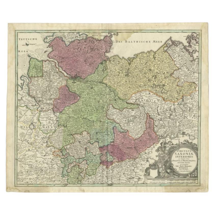
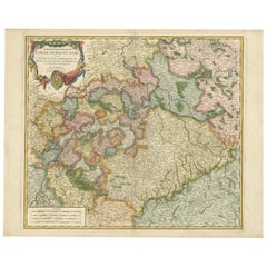
Antique Map of the Lower Saxony Region by Homann, c.1730
By Johann Baptist Homann
Located in Langweer, NL
Antique map titled 'Circulus Saxoniae Inferioris (..)'. Map of the Circle of Lower Saxony. The map covers most of present-day northern Germany, as far south as Göttingen, including m...
Category
Antique 18th Century Maps
Materials
Paper

$181 Sale Price
20% Off
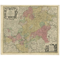
Antique Map of Northern Germany by M. Seutter, circa 1730
By Matthew Seutter
Located in Langweer, NL
Antique map titled 'Saxoniae Inferioris Circulus'. Old map of the northern part of Germany by M. Seutter. Covering the area of Lower Saxony, Mecklenburg-Vorpommern and Schleswig-Hols...
Category
Antique Mid-18th Century Maps
Materials
Paper

$565 Sale Price
20% Off
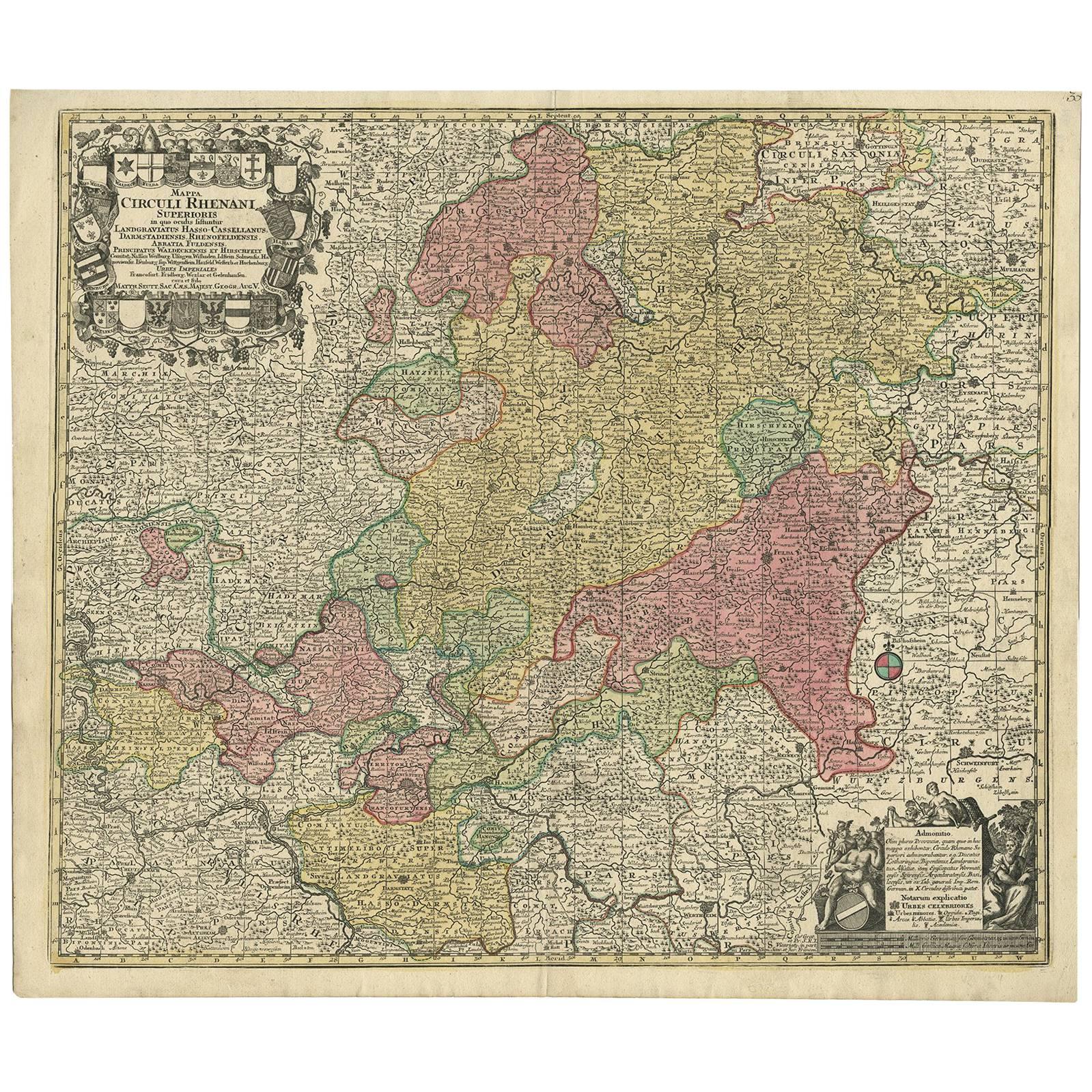
Hand-Colored Antique Map of part of Germany by M. Seutter, c. 1730
By Matthew Seutter
Located in Langweer, NL
Antique map titled 'Mappa Circuli Rhenani Superioris (..). Original map with hand coloring of part of Germany. It includes the region of Kassel, Göttingen, Eisenach, Schweinfurt, Wer...
Category
Antique Mid-18th Century Maps
Materials
Paper
$565 Sale Price
20% Off
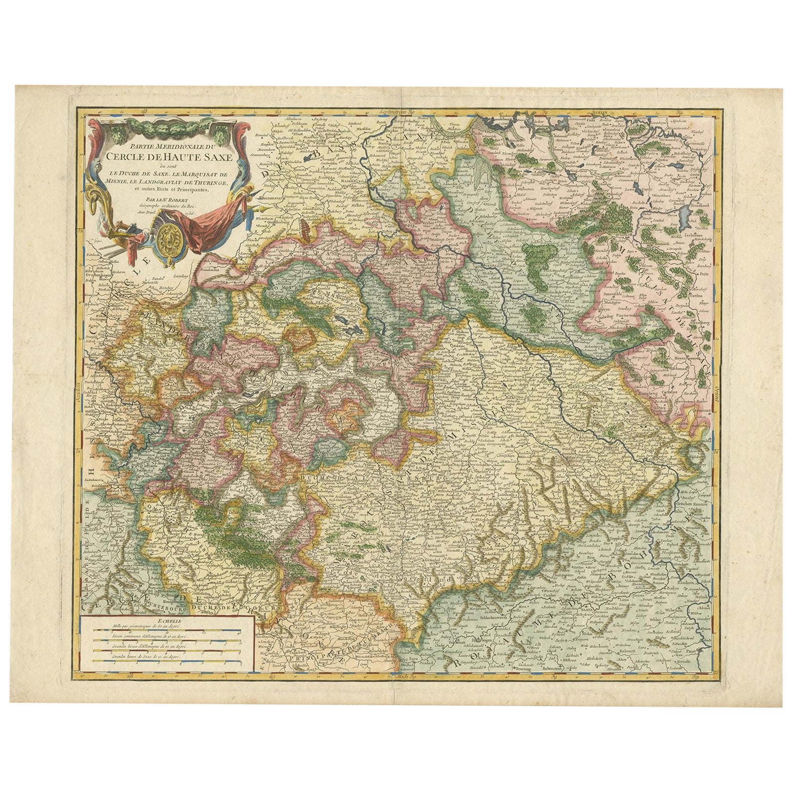
Nicely Colored Original Antique Map of Upper Saxony, Middle Germany, 1756
Located in Langweer, NL
Antique map titled 'Partie Meridionale du cercle de Haute Saxe (..)'.
Original antique map of upper Saxony, Germany. It was the name given to the majority of the German lands held by the House of Wettin, in what is now called Central Germany.
Artists and Engravers: Gilles Robert de Vaugondy (1688 - 1766), also known as Le Sieur or Monsieur Robert, and his son, Didier Robert de Vaugondy (c.1723 - 1786), were leading mapmakers in France during the 18th century. In 1757, they published The Atlas Universel, one of the most important atlases of the 18th century. To produce the atlas, the Vaugondys integrated older sources with more modern surveyed maps...
Category
Antique 1750s Maps
Materials
Paper
$1,102 Sale Price
20% Off
1720 Johann Baptist Homann Map of the Austrian Circle and Surrounding Regions
Located in Langweer, NL
"1720 Johann Baptist Homann Map of the Austrian Circle and Surrounding Regions"
Description of the Map:
This map, crafted by the renowned cartographer Johann Baptist Homann around...
Category
Antique 1720s Maps
Materials
Paper
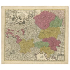
$738 Sale Price
20% Off
Antique Map of the Duchies of Bremen and Verden by Homann, c.1730
By Johann Baptist Homann
Located in Langweer, NL
Antique map titled 'Ducatus Bremae et Ferdae (..)'. Map of the Duchies of Bremen and Verden, Germany. Source unknown, to be determined.
Artists and Engravers: Johann Baptist Homan...
Category
Antique 18th Century Maps
Materials
Paper
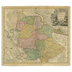
$223 Sale Price
20% Off