Items Similar to Antique Chart of the Voyage of Captain Cook by Benard, 1780

Want more images or videos?
Request additional images or videos from the seller
1 of 6
Antique Chart of the Voyage of Captain Cook by Benard, 1780
$264.65
$330.8120% Off
£198.37
£247.9620% Off
€224
€28020% Off
CA$363.58
CA$454.4720% Off
A$405.90
A$507.3820% Off
CHF 212.69
CHF 265.8620% Off
MX$4,968.62
MX$6,210.7720% Off
NOK 2,701.11
NOK 3,376.3920% Off
SEK 2,546.80
SEK 3,183.5120% Off
DKK 1,705.17
DKK 2,131.4620% Off
About the Item
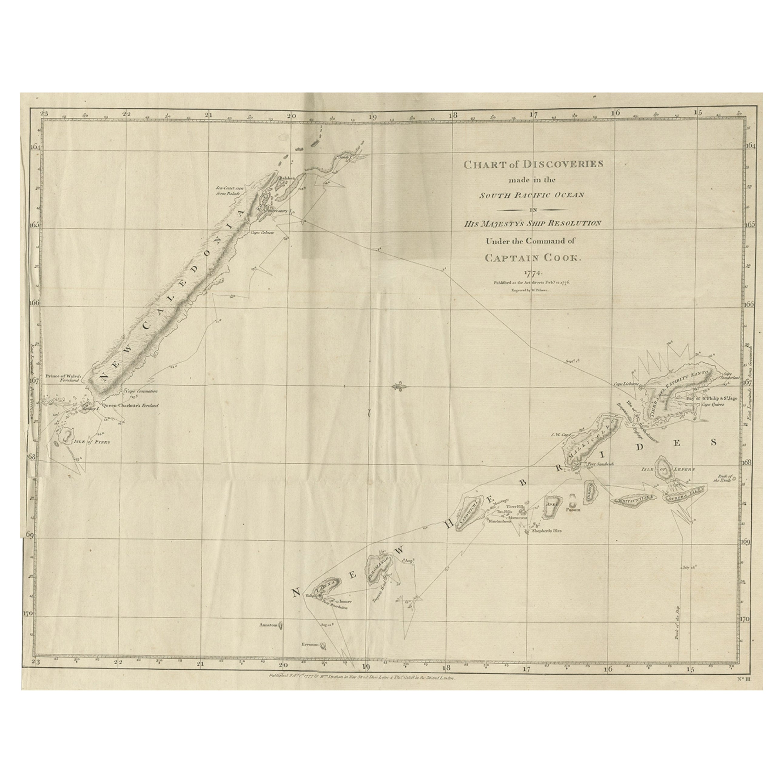
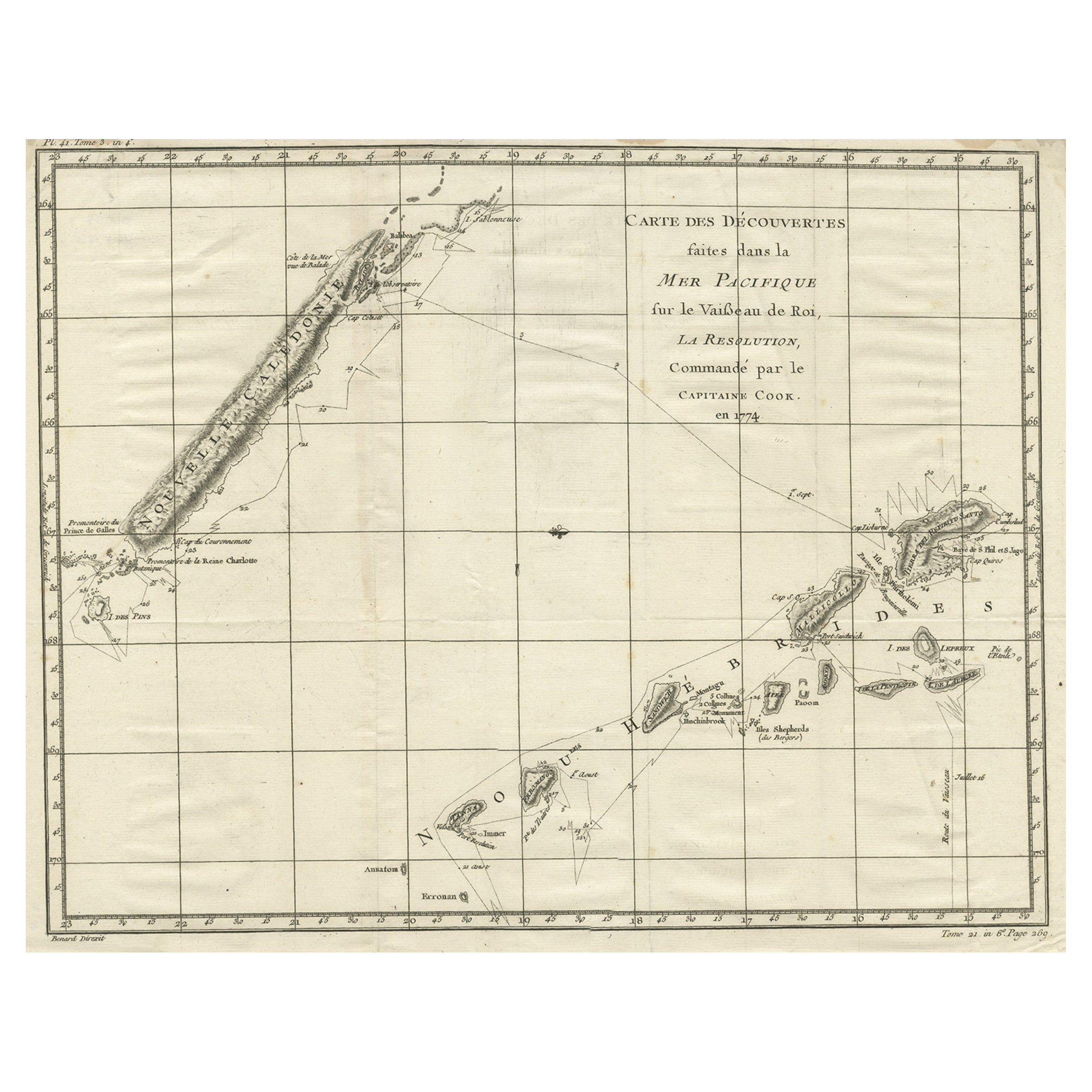
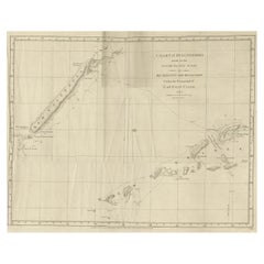
Antique map titled 'Carte des Découvertes faites dans la Mer Pacifique sur la Vaisse au de Roi, La Resolution, Commandé par le Capitaine Cook en 1774'. Chart detailing the 1774 voyage of Captain Cook in the Pacific, showing the track and dates of the Resolution near New Caledonia and New Hebrides. Originates from 'Voyage das L’Hemisphere Austral, et autour du Monde (..)'.
Artists and Engravers: Engraved by Benard. Published by La Harpe, Paris.
Condition: Good,general age-related toning. Few creases, please study image carefully.
Date: 1780
Overall size: 54 x 41.5 cm.
Image size: 46.5 x 36 cm.
We sell original antique maps to collectors, historians, educators and interior decorators all over the world. Our collection includes a wide range of authentic antique maps from the 16th to the 20th centuries. Buying and collecting antique maps is a tradition that goes back hundreds of years. Antique maps have proved a richly rewarding investment over the past decade, thanks to a growing appreciation of their unique historical appeal. Today the decorative qualities of antique maps are widely recognized by interior designers who appreciate their beauty and design flexibility. Depending on the individual map, presentation, and context, a rare or antique map can be modern, traditional, abstract, figurative, serious or whimsical. We offer a wide range of authentic antique maps for any budget.
- Dimensions:Height: 16.34 in (41.5 cm)Width: 21.26 in (54 cm)Depth: 0 in (0.01 mm)
- Materials and Techniques:
- Period:
- Date of Manufacture:1780
- Condition:Condition: Good,general age-related toning. Few creases, please study image carefully.
- Seller Location:Langweer, NL
- Reference Number:Seller: BGJC-2341stDibs: LU3054329623482
About the Seller
5.0
Recognized Seller
These prestigious sellers are industry leaders and represent the highest echelon for item quality and design.
Platinum Seller
Premium sellers with a 4.7+ rating and 24-hour response times
Established in 2009
1stDibs seller since 2017
2,513 sales on 1stDibs
Typical response time: <1 hour
- ShippingRetrieving quote...Shipping from: Langweer, Netherlands
- Return Policy
Authenticity Guarantee
In the unlikely event there’s an issue with an item’s authenticity, contact us within 1 year for a full refund. DetailsMoney-Back Guarantee
If your item is not as described, is damaged in transit, or does not arrive, contact us within 7 days for a full refund. Details24-Hour Cancellation
You have a 24-hour grace period in which to reconsider your purchase, with no questions asked.Vetted Professional Sellers
Our world-class sellers must adhere to strict standards for service and quality, maintaining the integrity of our listings.Price-Match Guarantee
If you find that a seller listed the same item for a lower price elsewhere, we’ll match it.Trusted Global Delivery
Our best-in-class carrier network provides specialized shipping options worldwide, including custom delivery.More From This Seller
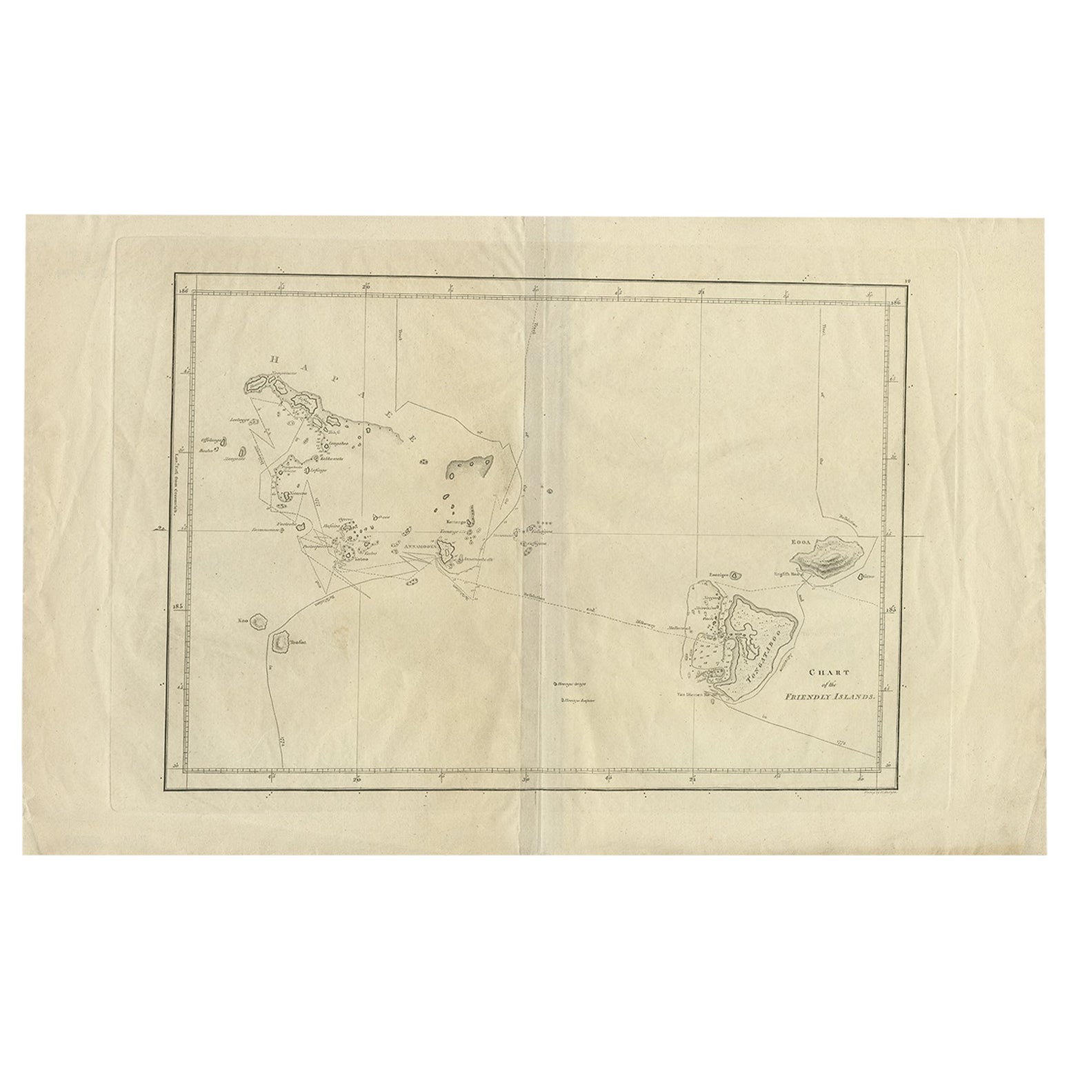
View AllAntique Chart of the Friendly Islands or Tonga in the Pacific Ocean, 1785
By James Cook
Located in Langweer, NL
Antique print titled 'Chart of the Friendly Islands'. Antique map of the Friendly Islands depicting Rotterdam or Anamocka, Middelburg or Eaoowe and Amsterdam or Tongatabu. Originates...
Category
Antique 18th Century Prints
Materials
Paper
$179 Sale Price
20% Off
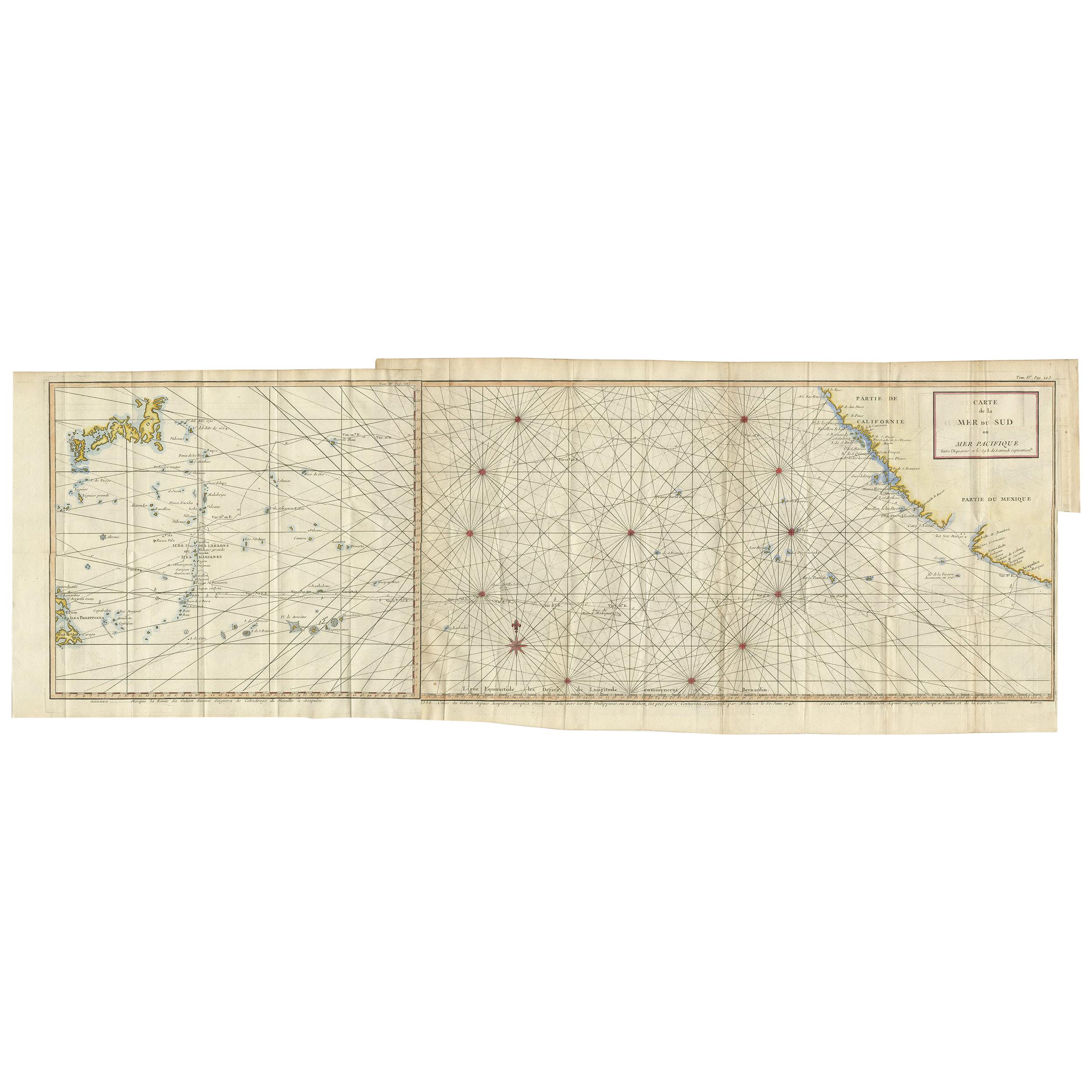
Antique Chart of the Mid-Pacific Ocean by Anson, 'c.1784'
Located in Langweer, NL
Antique map titled 'Carte de la Mer du Sud ou Mer Pacifique'. Original chart of the mid-Pacific Ocean, includes voyage tracks of Anson’s Centurion and the ship he stalked, the Spanish treasure...
Category
Antique Late 18th Century Maps
Materials
Paper
$1,329 Sale Price
25% Off
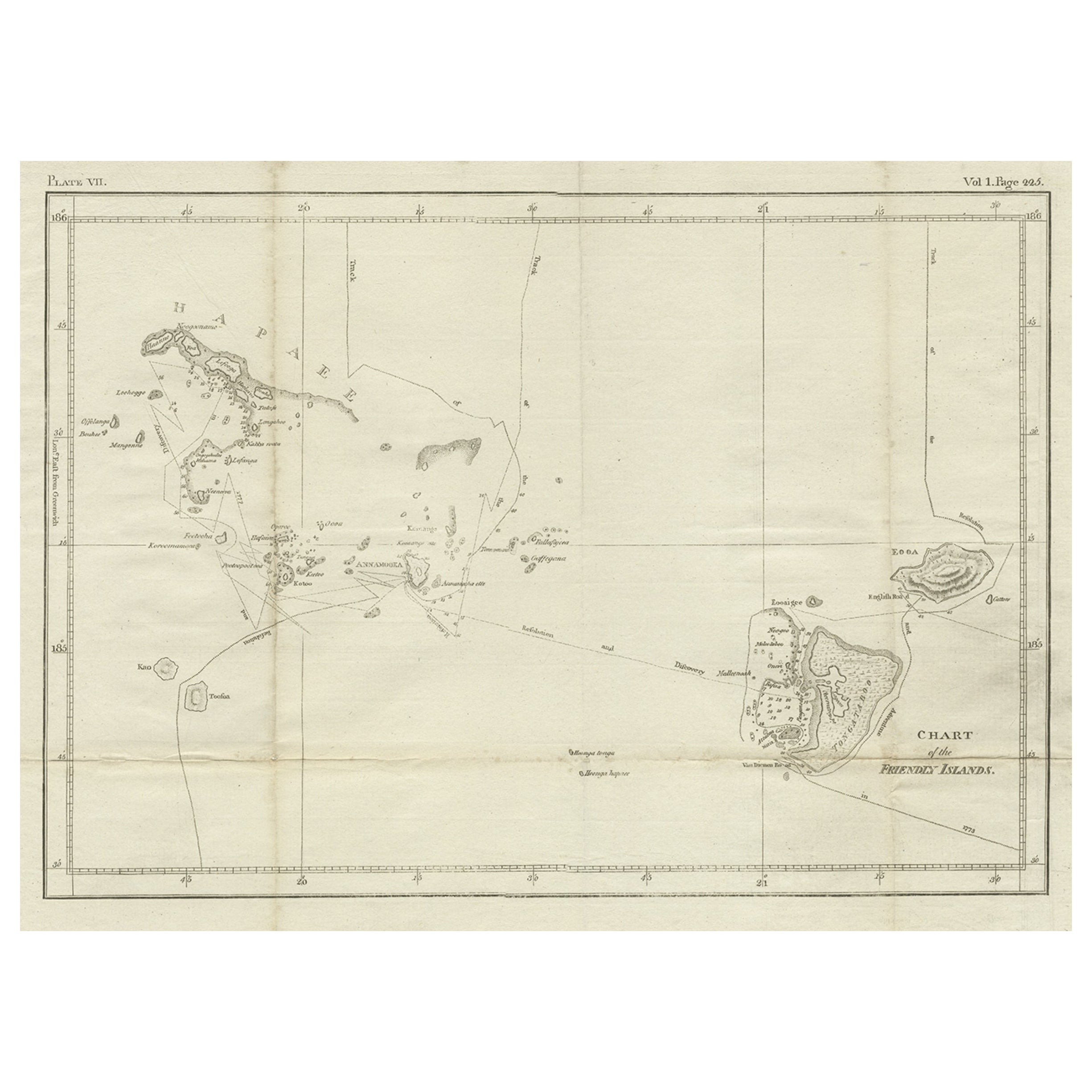
Antique Chart of the Friendly Islands or Nowadays Tonga, by Cook, 1784
By James Cook
Located in Langweer, NL
Antique print titled 'Chart of the Friendly Islands'. Antique map of the Friendly Islands depicting Rotterdam or Anamocka, Middelburg or Eaoowe and Amsterdam or Tongatabu. Originates...
Category
Antique 18th Century Prints
Materials
Paper
$321 Sale Price
20% Off
Antique Map of New Guinea and New Britain by P. Carteret, circa 1773
Located in Langweer, NL
Antique Map: A Chart of Captain Carteret's Discoveries at New Britain (1769)
This rare and historically significant 18th-century map, titled *A Chart of Captn Carteret's Discoveries at New Britain,* offers a fascinating glimpse into early European explorations of the Pacific. Published in 1769, the map meticulously charts Captain Philip Carteret's 1767 voyage through New Guinea and the islands of New Britain and New Ireland, showcasing his contributions to the understanding of the Bismarck Archipelago. Adding to its significance, the map traces the paths of earlier explorer William Dampier...
Category
Antique Late 18th Century Maps
Materials
Paper

$519 Sale Price
20% Off
Rare Engraving of New Caledonia & New Hebrides from Capt. Cook's Travels, 1777
Located in Langweer, NL
Antique map titled 'Chart of Discoveries made in the South Pacific Ocean'.
Rare engraving from the official British Admiralty sanctioned edition of the accounts of Cook’s second voyage. All other later copies made of this image by other publishers were unauthorised, usually smaller and inferior in quality. Made after Cook's discovery of the island group on 4 September 1774, which he named New Caledonia...
Category
Antique 1770s Maps
Materials
Paper
$708 Sale Price
20% Off
Old Engraving of the Track of the Resolution Captain Cook in the Pacific, 1780
Located in Langweer, NL
Antique map titled 'Carte des Découvertes faites dans la Mer Pacifique sur la Vaisse au de Roi, La Resolution, Commandé par le Capitaine Cook en 1774'. Chart detailing the 1774 voyag...
Category
Antique 18th Century Maps
Materials
Paper
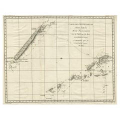
$406 Sale Price
20% Off
You May Also Like
Captain Cook's Exploration of Tahiti 18th C. Hand-Colored Map by Bellin
By Jacques-Nicolas Bellin
Located in Alamo, CA
This beautiful 18th century hand-colored copper plate engraved map is entitled "Carte de l'Isle de Taiti, par le Lieutenant J. Cook" was created by Jacques Nicolas Bellin and publish...
Category
Antique Mid-18th Century French Maps
Materials
Paper

1844 French Antique Nautical print Engraved Portolano of Syrie by Antoine Roux
By Antoine Roux
Located in Milan, IT
Antique portolano, nautical map of Syrie engraved on a copper plate by Antoine Roux, Marseille France 1844, from his work Recueil des principaux plans des ports et de Rades de la Mer...
Category
Antique 1840s French Nautical Objects
Materials
Paper
Ancient Map of Oceania - Original Etching - 19th century
Located in Roma, IT
This Map of Oceania is an etching realized in the 19th century.
The state of preservation of the artwork is good. At the top of the paper, the inscription “Longitudine del Meridiano...
Category
19th Century More Prints
Materials
Etching

Antique Maritime Chart of East Coast Virginia to Nova Scotia
Located in Norwell, MA
1920 nautical chart of the East Coast of the United States from Virginia to Maine, New Brunswick, and Nova Scotia. The chart shows Cape Cod, Long Island, the Connecticut coast, Jersey Shore, Maine, New Hampshire, etc. Very detailed, showing ports, lighthouses, shoals, depths, etc. The chart is by famous cartographer George W. Eldridge, compiled from surveys of the United States government, British Admiralty, George Eldridge, and others. First authorized by George Eldridge, published in 1916 by Wilfred O. White with a merchant's stamp of Charles Hutchinson...
Category
Vintage 1920s North American Maps
Materials
Paper

Captain Cook's Exploration of Tahiti: 18th C. Hand-colored Map by Bellin
By Jacques-Nicolas Bellin
Located in Alamo, CA
This beautiful 18th century hand-colored copper plate engraved map is entitled "Carte de l'Isle de Taiti, par le Lieutenant J. Cook" was created by Jacques Nicolas Bellin and publish...
Category
Late 18th Century Landscape Prints
Materials
Engraving

Original Antique Map of South America. C.1780
Located in St Annes, Lancashire
Great map of South America
Copper-plate engraving
Published C.1780
Two small worm holes to left side of map
Unframed.
Category
Antique Early 1800s English Georgian Maps
Materials
Paper

More Ways To Browse
Antique Cook
Captain Cook
Peninsular War
Ukraine Antique Map
Antique Life Buoy
Antique Map Nova Scotia
Antique Map Of Argentina
Antique Maps Of Kansas
Cambodia Antique Map
Magellan Map
Map Ukraine
Mariners Chart
Papua New Guinea Antique Map
Bermuda Map
Scan Globe
Tunisia Antique Map
Antique Map New Orleans
Antique Maps Of Maryland