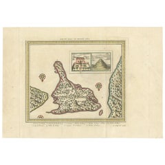
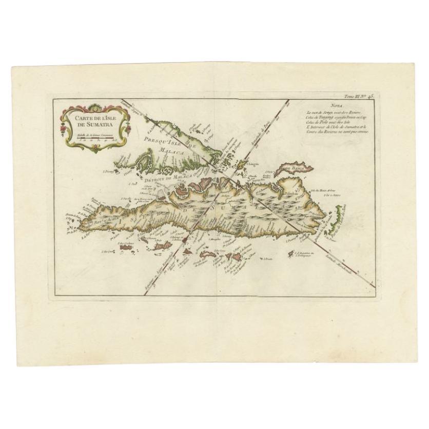
Antique Map of Bali 'Indonesia' by Bellin '1757'
View Similar Items


Want more images or videos?
Request additional images or videos from the seller
1 of 5
Antique Map of Bali 'Indonesia' by Bellin '1757'
$359.75List Price
About the Item
- Dimensions:Height: 10.04 in (25.5 cm)Width: 14.38 in (36.5 cm)Depth: 0.02 in (0.5 mm)
- Materials and Techniques:
- Period:
- Date of Manufacture:1757
- Condition:
- Seller Location:Langweer, NL
- Reference Number:Seller: BGJC-363-31stDibs: LU3054317572301
About the Seller
5.0
Recognized Seller
These prestigious sellers are industry leaders and represent the highest echelon for item quality and design.
Platinum Seller
Premium sellers with a 4.7+ rating and 24-hour response times
Established in 2009
1stDibs seller since 2017
2,510 sales on 1stDibs
Authenticity Guarantee
In the unlikely event there’s an issue with an item’s authenticity, contact us within 1 year for a full refund. DetailsMoney-Back Guarantee
If your item is not as described, is damaged in transit, or does not arrive, contact us within 7 days for a full refund. Details24-Hour Cancellation
You have a 24-hour grace period in which to reconsider your purchase, with no questions asked.Vetted Professional Sellers
Our world-class sellers must adhere to strict standards for service and quality, maintaining the integrity of our listings.Price-Match Guarantee
If you find that a seller listed the same item for a lower price elsewhere, we’ll match it.Trusted Global Delivery
Our best-in-class carrier network provides specialized shipping options worldwide, including custom delivery.More From This Seller
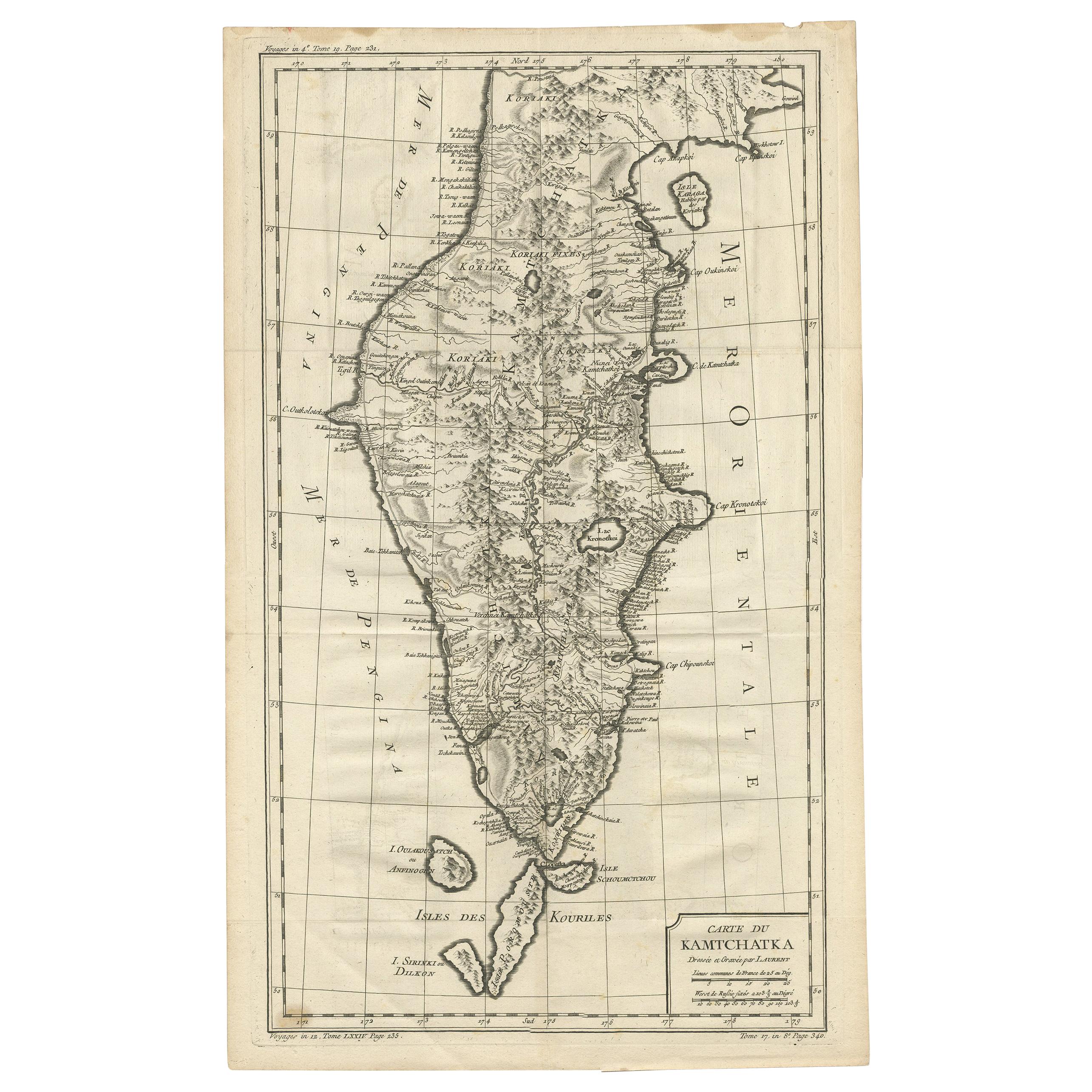
View AllAntique Map of Kamchatka by Bellin, '1757'
By Jacques-Nicolas Bellin
Located in Langweer, NL
Antique map titled 'Carte du Kamtchatka'. Antique map of the Kamchatka Peninsula. The map includes the island of Ouiakous Atch ou Anfinogen, Schoumctchou, and Sirinki ou Dilkon. Orig...
Category
Antique Mid-18th Century Maps
Materials
Paper
$268 Sale Price
20% Off
Antique Map of the Kamchatka Peninsula by Bellin, 1757
By J. Laurent
Located in Langweer, NL
Antique map titled 'Carte du Kamtchatka'. Antique map of the Kamchatka Peninsula. The map includes the island of Ouiakous Atch ou Anfinogen, Schoumctchou, and Sirinki ou Dilkon. Orig...
Category
Antique 18th Century Maps
Materials
Paper
$157 Sale Price
20% Off
Antique Map of Nova Zembla 'Russia' by J.N. Bellin, 1757
Located in Langweer, NL
Decorative map of Nova Zembla and environs in the Arctic Sea. Includes a large decorative title cartouche. One of the maps produced by Jacques-Nicolas Bellin for Prevost d'Exiles inf...
Category
Antique Mid-18th Century Maps
Materials
Paper

$263 Sale Price
20% Off
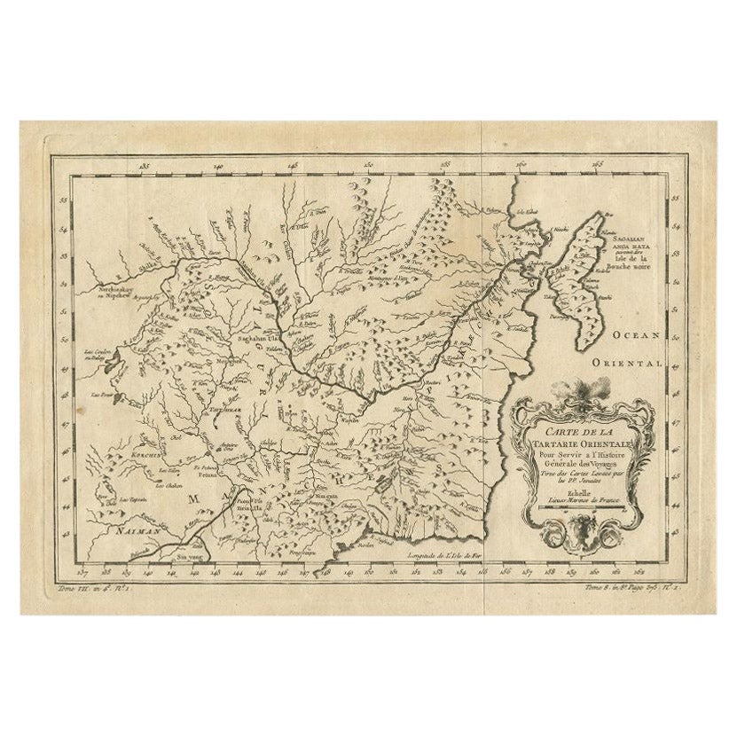
Antique Map of Northern China and Eastern Russia by Bellin, 1757
Located in Langweer, NL
Antique map titled 'Carte de la Tartarie Orientale (..)'. Original antique map of what is present day northern China and far eastern Russia. Centered on...
Category
Antique 18th Century Maps
Materials
Paper
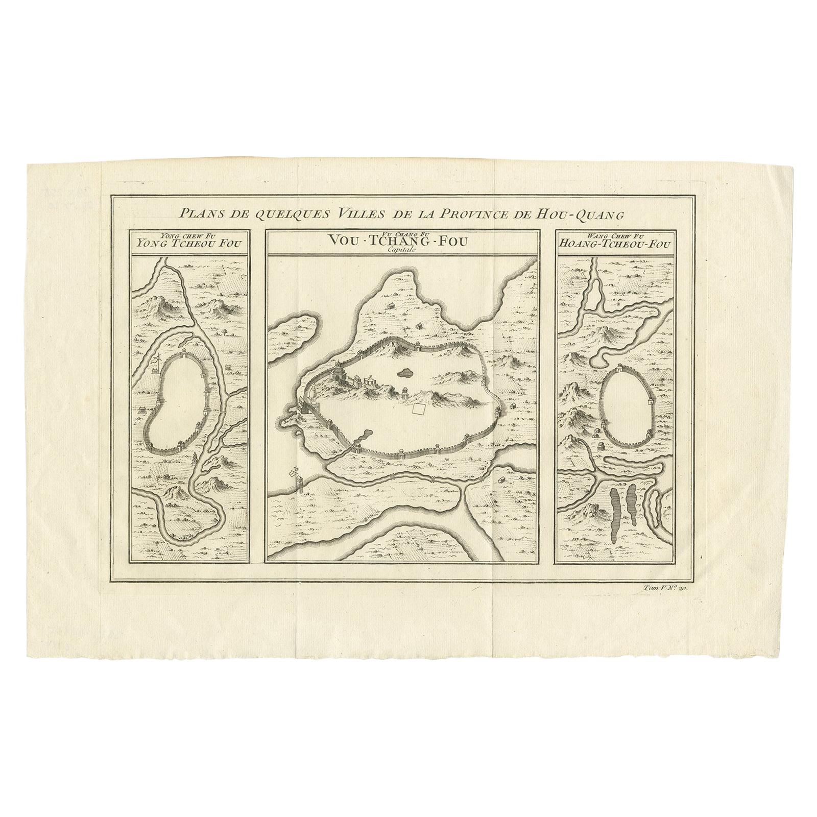
Antique Map of Three Cities of China's Hubei and Hunan Provinces by Bellin
By Jacques-Nicolas Bellin
Located in Langweer, NL
Antique print titled 'Plans de Quelques villes de la province de Hou-Quang.' Three bird's-eye view plans of walled cities in what are now China's Hubei (Hou-Quang) and Hunan Province...
Category
Antique Mid-18th Century Maps
Materials
Paper
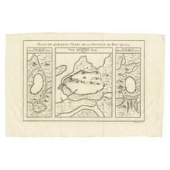
$158 Sale Price
20% Off
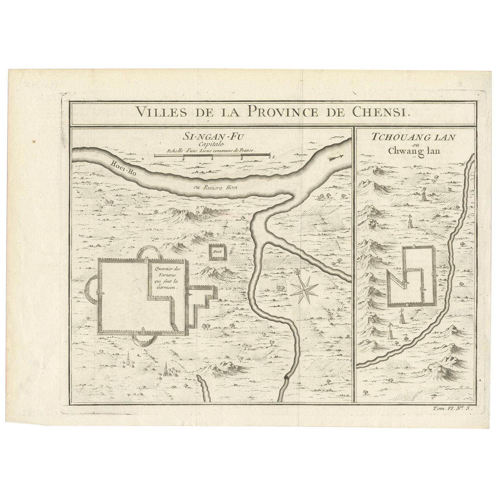
Antique Map of Si-Ngan-fu and Tchang Lan 'China' by Bellin '1748'
By Jacques-Nicolas Bellin
Located in Langweer, NL
Antique map China titled ‘Villes de la Province de Chensi’. Interesting set of two local town plans of "Si-Ngan-Fu: Capitale, Hoofdstad." and "Tchang...
Category
Antique Mid-18th Century Maps
Materials
Paper
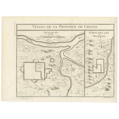
$143 Sale Price
20% Off
You May Also Like
Original Antique Map of India by Dower, circa 1835
Located in St Annes, Lancashire
Nice map of India
Drawn and engraved by J.Dower
Published by Orr & Smith. C.1835
Unframed.
Free shipping
Category
Antique 1830s English Maps
Materials
Paper

Original Antique Map of Australia by Dower, circa 1835
Located in St Annes, Lancashire
Nice map of Australia
Drawn and engraved by J.Dower
Published by Orr & Smith. C.1835
Unframed.
Free shipping
Category
Antique 1830s English Maps
Materials
Paper

Original Antique Map of Africa by Dower, circa 1835
Located in St Annes, Lancashire
Nice map of Africa
Drawn and engraved by J.Dower
Published by Orr & Smith. C.1835
Unframed.
Free shipping
Category
Antique 1830s English Maps
Materials
Paper

Original Antique Map of Scotland by Dower, circa 1835
Located in St Annes, Lancashire
Nice map of Scotland
Drawn and engraved by J.Dower
Published by Orr & Smith. C.1835
Unframed.
Free shipping
Category
Antique 1830s English Maps
Materials
Paper

Large Original Antique Map of Poland by Sidney Hall, 1847
Located in St Annes, Lancashire
Great map of Poland
Drawn and engraved by Sidney Hall
Steel engraving
Original colour outline
Published by A & C Black. 1847
Unframed
...
Category
Antique 1840s Scottish Maps
Materials
Paper

Large Original Antique Map of Australia by Sidney Hall, 1847
Located in St Annes, Lancashire
Great map of Australia
Drawn and engraved by Sidney Hall
Steel engraving
Original colour outline
Published by A & C Black. 1847
Unframed
Free shipping.
Category
Antique 1840s Scottish Maps
Materials
Paper

Recently Viewed
View AllMore Ways To Browse
Balinese Antique Furniture
Bali Temple
Bali Map
Balinese Temple
Antique Maps Of Italy
Antique Map India
Antique Topographic Maps
Antique Railroad
Antique Maps Of Africa
Railroad Furniture
Antiques Compasses
Antique House Plans
Antique Navigation
Colonial Furniture Company
Mississippi Furniture
Antique Scottish Wood Furniture
Indonesia Map
Antique Framed Map Engravings