Items Similar to Antique Map of Delfland by Cruquius, 1712


Want more images or videos?
Request additional images or videos from the seller
1 of 6
Antique Map of Delfland by Cruquius, 1712
$709.91
$887.3920% Off
£528.10
£660.1320% Off
€592
€74020% Off
CA$972.11
CA$1,215.1420% Off
A$1,080.86
A$1,351.0720% Off
CHF 564.37
CHF 705.4620% Off
MX$13,156.69
MX$16,445.8720% Off
NOK 7,201.05
NOK 9,001.3220% Off
SEK 6,747.04
SEK 8,433.8020% Off
DKK 4,506.57
DKK 5,633.2120% Off
Shipping
Retrieving quote...The 1stDibs Promise:
Authenticity Guarantee,
Money-Back Guarantee,
24-Hour Cancellation
About the Item
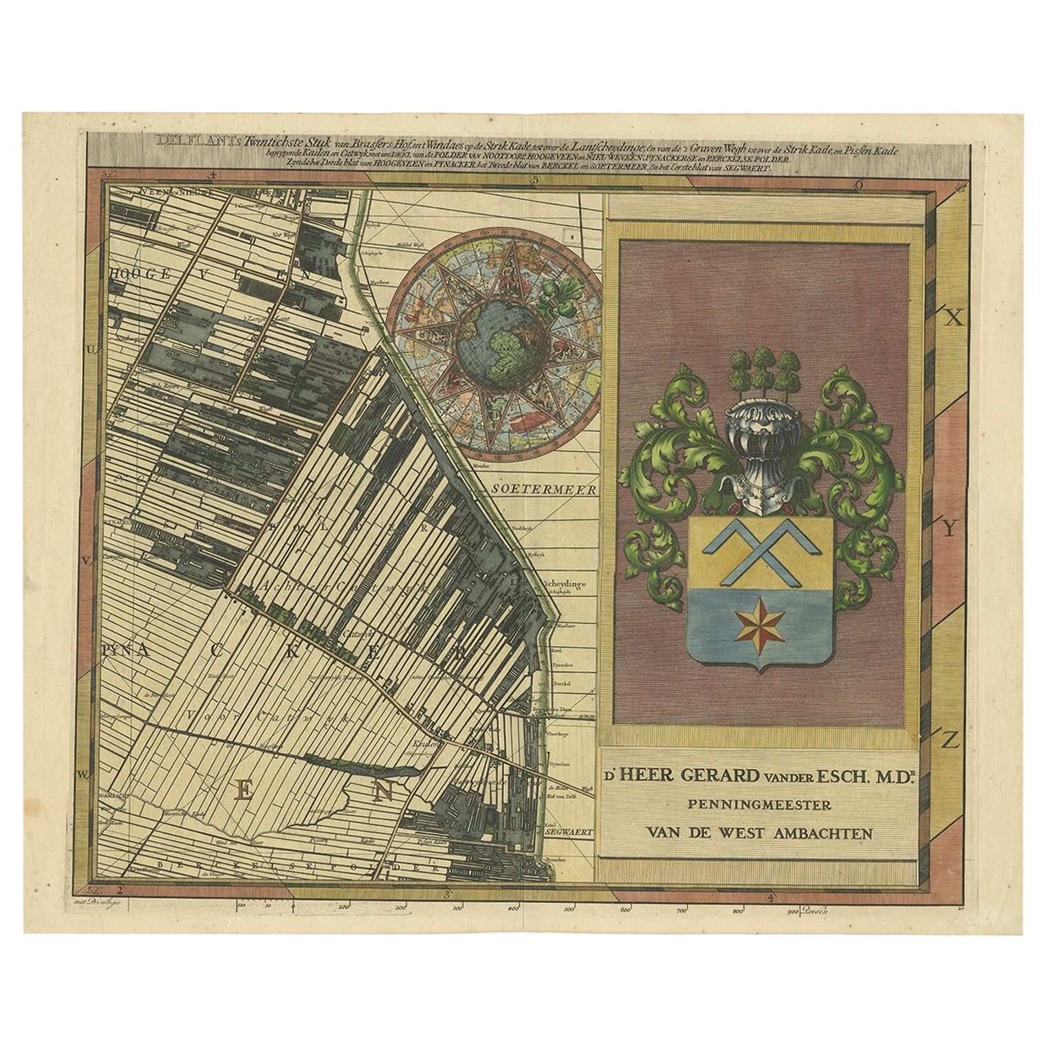
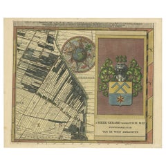
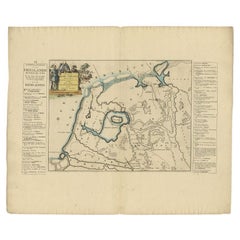
Map no. 25 of a large wall map of Delfland, The Netherlands. The map covers the region of Polder Berkel. To the right, coat of arms of 'De Staten van Hollant'.
Artists and Engravers: Nicolaes en Jacob Cruquius (Kruikius).
Condition: Very good, please study image carefully.
Date: 1712
Overall size: 65 x 54 cm.
Image size: 58 x 50 cm.
We sell original antique maps to collectors, historians, educators and interior decorators all over the world. Our collection includes a wide range of authentic antique maps from the 16th to the 20th centuries. Buying and collecting antique maps is a tradition that goes back hundreds of years. Antique maps have proved a richly rewarding investment over the past decade, thanks to a growing appreciation of their unique historical appeal. Today the decorative qualities of antique maps are widely recognized by interior designers who appreciate their beauty and design flexibility. Depending on the individual map, presentation, and context, a rare or antique map can be modern, traditional, abstract, figurative, serious or whimsical. We offer a wide range of authentic antique maps for any budget.
- Dimensions:Height: 21.26 in (54 cm)Width: 25.6 in (65 cm)Depth: 0 in (0.01 mm)
- Materials and Techniques:
- Period:
- Date of Manufacture:1712
- Condition:Condition: Very good, please study image carefully.
- Seller Location:Langweer, NL
- Reference Number:Seller: BGI-001641stDibs: LU3054329625872
About the Seller
5.0
Recognized Seller
These prestigious sellers are industry leaders and represent the highest echelon for item quality and design.
Platinum Seller
Premium sellers with a 4.7+ rating and 24-hour response times
Established in 2009
1stDibs seller since 2017
2,511 sales on 1stDibs
Typical response time: <1 hour
- ShippingRetrieving quote...Shipping from: Langweer, Netherlands
- Return Policy
Authenticity Guarantee
In the unlikely event there’s an issue with an item’s authenticity, contact us within 1 year for a full refund. DetailsMoney-Back Guarantee
If your item is not as described, is damaged in transit, or does not arrive, contact us within 7 days for a full refund. Details24-Hour Cancellation
You have a 24-hour grace period in which to reconsider your purchase, with no questions asked.Vetted Professional Sellers
Our world-class sellers must adhere to strict standards for service and quality, maintaining the integrity of our listings.Price-Match Guarantee
If you find that a seller listed the same item for a lower price elsewhere, we’ll match it.Trusted Global Delivery
Our best-in-class carrier network provides specialized shipping options worldwide, including custom delivery.More From This Seller
View AllLarge Antique Map of Delfland by Cruquius, 1712
Located in Langweer, NL
Map no. 20 of a large wall map of Delfland, The Netherlands. The map covers the region of Pijnacker with a large compass rose with allegorical figures a...
Category
Antique 18th Century Maps
Materials
Paper
$709 Sale Price
20% Off
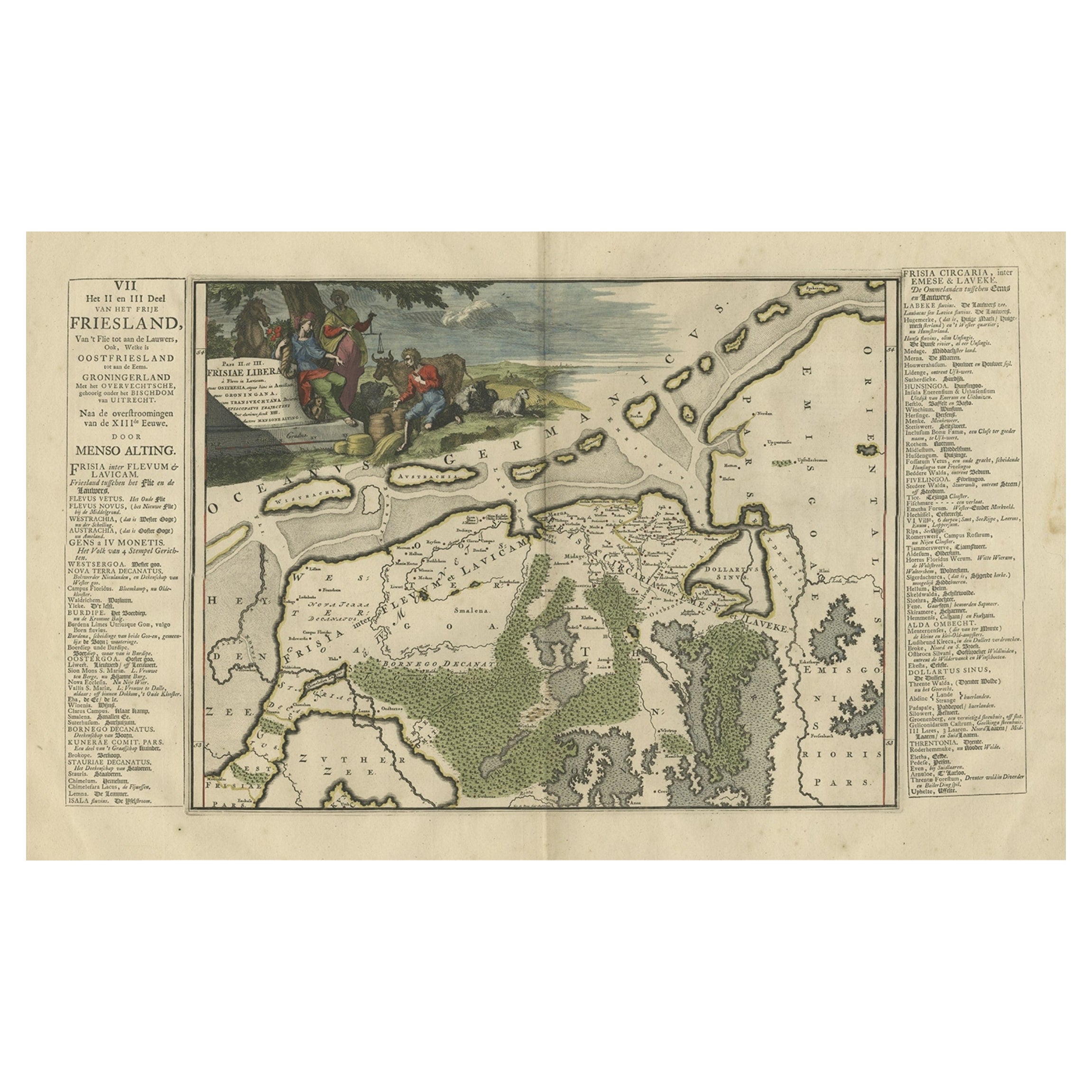
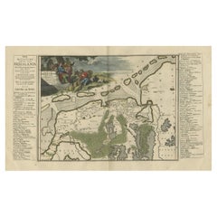
Antique Map of Friesland after the Floods of the 13th Century, 1718
Located in Langweer, NL
Antique map Friesland titled 'Pars II et III Frisiae Libera(..)'. Old map of Friesland, the Netherlands, after the floods of the 13th century. Originates from 'Uitbeelding van de Hee...
Category
Antique 18th Century Maps
Materials
Paper
$335 Sale Price
20% Off
Antique Map of the Province Groningen in The Netherlands, c.1680
Located in Langweer, NL
Antique map titled 'Groningae et Omlandiae Dominium vulgo de Provincie van Stadt en Lande'.
Old map of the province of Groningen, the Netherlands. This map originates from 'Germani...
Category
Antique 17th Century Maps
Materials
Paper

$470 Sale Price
20% Off
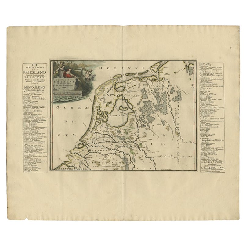
Antique Map of Friesland in the Time of the Franks, 1718
Located in Langweer, NL
Antique map Friesland titled 'Descriptio Frisiae sub Francorum reditum (..)'. Old map of Friesland, the Netherlands, in the time of the Franks. Originates from 'Uitbeelding van de He...
Category
Antique 18th Century Maps
Materials
Paper
$244 Sale Price
20% Off
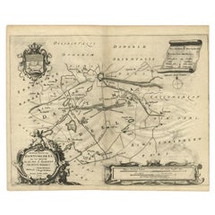
Antique Map of the Region of Dantumadeel, Friesland, The Netherlands, 1664
Located in Langweer, NL
Antique map titled 'De Grietenije van Dantuma deel (..)'. Map of the Grietenij of Dantumadeel, Friesland, The Netherlands. Multiple cartouches, key and coat of arms. Originates from ...
Category
Antique 17th Century Maps
Materials
Paper
$187 Sale Price
20% Off
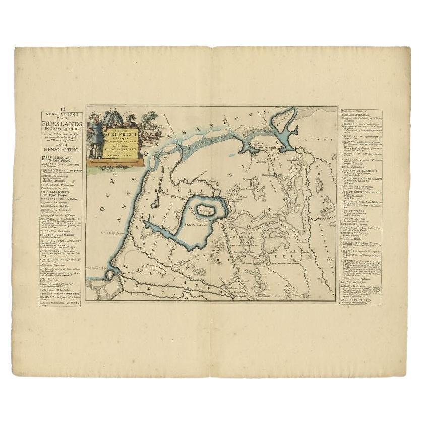
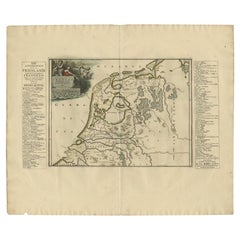
Antique Map of the Old Lands of Friesland by Halma, 1718
Located in Langweer, NL
Antique map Friesland titled 'Descriptio Agri Frisii (..)'. Old map of Friesland, the Netherlands. This map depicts the old lands of Friesland. Originates from 'Uitbeelding van de He...
Category
Antique 18th Century Maps
Materials
Paper
$220 Sale Price
20% Off
You May Also Like
17th Century Hand Colored Map of the Liege Region in Belgium by Visscher
By Nicolaes Visscher II
Located in Alamo, CA
An original 17th century map entitled "Leodiensis Episcopatus in omnes Subjacentes Provincias distincté divisusVisscher, Leodiensis Episcopatus" by Nicolaes Visscher II, published in Amsterdam in 1688. The map is centered on Liege, Belgium, includes the area between Antwerp, Turnhout, Roermond, Cologne, Trier and Dinant.
This attractive map is presented in a cream-colored mat measuring 30" wide x 27.5" high. There is a central fold, as issued. There is minimal spotting in the upper margin and a tiny spot in the right lower margin, which are under the mat. The map is otherwise in excellent condition.
The Visscher family were one of the great cartographic families of the 17th century. Begun by Claes Jansz Visscher...
Category
Antique Late 17th Century Dutch Maps
Materials
Paper

1752 Vaugoundy Map of Flanders : Belgium, France, and the Netherlands, Ric.a002
Located in Norton, MA
Large Vaugoundy Map of Flanders:
Belgium, France, and the Netherlands
Colored -1752
Ric.a002
Description: This is a 1752 Didier Robert de Vaugondy map of Flanders. The map de...
Category
Antique 17th Century Unknown Maps
Materials
Paper

1643 Willem&Joan Blaeu Map NW Flanders "Flandriae Teutonicae Pars Prientalior
Located in Norton, MA
1643 Willem and Joan Blaeu map of northwest Flanders, entitled
"Flandriae Teutonicae Pars Prientalior,"
Ric0012
" Authentic" - Map of the northwest Fl...
Category
Antique 17th Century Dutch Maps
Materials
Paper

1635 Willem Blaeu Map of Northern France"Comitatvs Bellovacvm" Ric.a08
Located in Norton, MA
1635 Willem Blaeu map of northern France, entitled.
"Comitatvs Bellovacvm Vernacule Beavvais,"
Colored
Ric.a008
“COMITATVS BELLOVACVM…” Amsterdam: W...
Category
Antique 17th Century Unknown Maps
Materials
Paper

1640 Joan Bleau Map Entitled"Diocecese de rheims et le pais de rethel, " Eic.a011
Located in Norton, MA
1640 Joan Bleau map entitled
"Diocecese de rheims et le pais de rethel,"
Ric.a011
OAN BLAEU
Diocecese de Rheims, et le pais de Rethel.
Handcolored engraving, c.1640.
...
Category
Antique 17th Century Dutch Maps
Materials
Paper

1657 Janssonius Map of Vermandois and Cappelle, Ric. A-004
Located in Norton, MA
1657 Janssonius map of
Vermandois and Cappelle
Ric.a004
Description: Antique map of France titled 'Descriptio Veromanduorum - Gouvernement de la Cappelle'. Two detailed maps o...
Category
Antique 17th Century Unknown Maps
Materials
Paper

More Ways To Browse
Large Wall Maps
Mariners Chart
Papua New Guinea Antique Map
Bermuda Map
Scan Globe
Tunisia Antique Map
Antique Map New Orleans
Antique Maps Of Maryland
Gambia Antique Map
Antique Manitoba
Antique Map Of Brooklyn
Antique Map Of Michigan
Cham Antiques
Map Of Native American Tribes
Antique Furniture Halifax Furniture
Antique Furniture Trinidad
Antique Kiel Furniture
Cornwall Map