Items Similar to Antique Map with Details of Berings' Expedition into Russians' Far East, 1737


Want more images or videos?
Request additional images or videos from the seller
1 of 6
Antique Map with Details of Berings' Expedition into Russians' Far East, 1737
$1,393.14
$1,741.4320% Off
£1,026.05
£1,282.5620% Off
€1,160
€1,45020% Off
CA$1,895.26
CA$2,369.0820% Off
A$2,106.06
A$2,632.5720% Off
CHF 1,103.60
CHF 1,379.4920% Off
MX$25,827.02
MX$32,283.7820% Off
NOK 14,075.72
NOK 17,594.6520% Off
SEK 13,241.92
SEK 16,552.4020% Off
DKK 8,830.90
DKK 11,038.6320% Off
Shipping
Retrieving quote...The 1stDibs Promise:
Authenticity Guarantee,
Money-Back Guarantee,
24-Hour Cancellation
About the Item
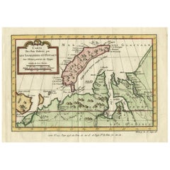
Antique map titled 'Carte Des Pays traverses par le Capne. Beerings depuis la Ville de Tobolsk jusqua'a Kamtschatka'.
This is the first printed map to illustrate Vitus Bering's first voyage, representing the first broadly accurate cartography of the Russian Far East.
In December 1724, Czar Peter the Great ordered the Danish-born Captain-Commander Vitus Bering (1681-1741) to lead the First Kamchatka Expedition (1725-30), in a effort to consoldate Russia's claims to regions in the Far East. Bering's party set out from St. Petersburg in January 1725, and after a grueling two-year journey, arrived in Okhotsk in Janaury 1727, on the Pacific Coast. The expedition then continued by ship to explore the massive Kamchatka Peninsula that runs down the East Coast of Siberia, and the shorelines beyond up to what is now the western side of the Bering Strait, dividing Asia from North America. As shown on the map, a series of forts, outposts and missions had already been established in the Russian Far East.
While Bering's expedition was by no means the first expedition to traverse Russia, it was the first to explore the coast beyond Kamchatka and to properly map the various river systems of the eastern interior of Siberia and to chart much of the Pacific Coast. The present map extends from Tobolsk in the west, the traditional capital of Siberia, all the way eastwards to embrace the Kamchatka Peninsula and the coastlines up to the easternmost point of the Chukchi Peninsula. In between are depicted large stretches of the Ob, Irtysh, and Lena Rivers, their tributaries and Lake Baikal, the World's deepest lake. The coastline, shown from Okhotsk, Russia's gateway the the Pacific (founded 1650), up to the Bering Strait is quite impressively mapped given the difficult circumstances in which Bering operated. The First Kamchatka Expedition was deemed a great success, and the Russian court was highly impressed by the vast distances travelled and the quality of Bering's maps and written reports.
Czarina Anna ordered Bering to lead a much larger multi-pronged expedition to the Far East. Although technically known as the Second Kamchatka Expedition (1732-41), this endeavor would have historic and far-reaching implications, as it would be the first expedition to discover and partially map what is now Alaska. It opened the way to the lengthy Russian presence on the Pacific Coast of North America (which would last until 1867), and the great period of exploration of the Pacific Northwest that would include the great names of Cook, Vancouver, Mackenizie and Lewis & Clark.
The first edition of this map appeared in Jean-Baptiste Du Halde's Description de la China (Paris, 1735), while the present edition was issued in Paris by the eminent cartographer J.B.B. D'Anville in 1737, which features cartouches added to the map. A critical map relating the exploration of the Russian Far East and the North Pacific.
Artists and Engravers: Jean Baptiste Bourguignon d'Anville (1697-1782) was a geographer and cartographer from France. His fame was established through his historical maps, which shows careful accurate work and are based largely on original research.
- Dimensions:Height: 12.96 in (32.9 cm)Width: 22.64 in (57.5 cm)Depth: 0 in (0.02 mm)
- Materials and Techniques:
- Period:1730-1739
- Date of Manufacture:1737
- Condition:Condition: Good, given age. A few small unobtrusive spots. Original folds as issued. General age-related toning and/or occasional minor defects from handling. Please study image carefully.
- Seller Location:Langweer, NL
- Reference Number:Seller: PC-58954 1stDibs: LU3054326631022
About the Seller
5.0
Recognized Seller
These prestigious sellers are industry leaders and represent the highest echelon for item quality and design.
Platinum Seller
Premium sellers with a 4.7+ rating and 24-hour response times
Established in 2009
1stDibs seller since 2017
2,494 sales on 1stDibs
Typical response time: 1 hour
- ShippingRetrieving quote...Shipping from: Langweer, Netherlands
- Return Policy
Authenticity Guarantee
In the unlikely event there’s an issue with an item’s authenticity, contact us within 1 year for a full refund. DetailsMoney-Back Guarantee
If your item is not as described, is damaged in transit, or does not arrive, contact us within 7 days for a full refund. Details24-Hour Cancellation
You have a 24-hour grace period in which to reconsider your purchase, with no questions asked.Vetted Professional Sellers
Our world-class sellers must adhere to strict standards for service and quality, maintaining the integrity of our listings.Price-Match Guarantee
If you find that a seller listed the same item for a lower price elsewhere, we’ll match it.Trusted Global Delivery
Our best-in-class carrier network provides specialized shipping options worldwide, including custom delivery.More From This Seller
View AllAntique Map of Nova Zembla 'Russia' by J.N. Bellin, 1757
Located in Langweer, NL
Decorative map of Nova Zembla and environs in the Arctic Sea. Includes a large decorative title cartouche. One of the maps produced by Jacques-Nicolas Bellin for Prevost d'Exiles inf...
Category
Antique Mid-18th Century Maps
Materials
Paper

$264 Sale Price
20% Off
Antique Map of Eastern Siberia by Bellin '1768'
Located in Langweer, NL
Antique map titled 'Suite de la Carte de la Siberie et le Pays de Kamtchatka'. Original antique map of the eastern portion of Siberia, centered on eastern Russia and the Mer d'Ochozk (Sea of Okhotsk) showing the Kamchatka Peninsula and I. de Beringe and I. Sagalin. The map shows the tracks of Russian ships...
Category
Antique Mid-18th Century Maps
Materials
Paper

$288 Sale Price
20% Off
Decorative Original Old Map of Nova Zembla and the Russian Mainland, ca.1760
Located in Langweer, NL
Antique map titled 'Carte Des Pais Habites par les Samojedes et Ostiacs.'
Map of Novaya Zemlya and the Russian mainland. Source unknown, to be determined.
Artists and Engraver...
Category
Antique 1760s Maps
Materials
Paper
$432 Sale Price
20% Off
Antique Map of Northern China and Far Eastern Russia Around the Amur River, 1754
Located in Langweer, NL
Antique map titled 'Carte De La Tartarie Orientale (..)'. A map for this far eastern portion of what is present day northern China and far eastern Russia...
Category
Antique 1750s Maps
Materials
Paper

$480 Sale Price
20% Off
Antique Map of Nova Zembla ‘Russia’ by J.N. Bellin, 1758
Located in Langweer, NL
An interesting map of Nova Zembla and surrounding areas. With details on the eastern tip of Nova Zembla of the place where the stranded Dutch sailors under Willem Barentsz spent the ...
Category
Antique Mid-18th Century Maps
Materials
Paper

$230 Sale Price
20% Off
Antique Map of Western Tartary and the Gobi Desert of the Russian Empire, c.1750
Located in Langweer, NL
Antique map titled 'A Map of Western Tartary Drawn from the Survey of the Jesuits and Mr. Kyrillow's Map of the Russian Empire'. Map of the Gobi Desert and the eastern portion of the...
Category
Antique 18th Century Maps
Materials
Paper

$336 Sale Price
20% Off
You May Also Like
Siberia as Explored by Behring: Original 18th Century Hand-colored Map by Bowen
Located in Alamo, CA
This is an original 18th century hand-colored map entitled "An Exact Chart of all the Countries through which Capt. Behring Travelled from Tobolski, Capital of Siberia to the Country...
Category
Mid-18th Century Old Masters Landscape Prints
Materials
Engraving

Von Reilly Map of the Russian Empire, 1796
Located in Savannah, GA
A map of the Russian Empire in Europe by Von Reilly. Published in Vienna, 1796.
32 inches wide by 24 ½ inches tall
Category
Antique 1790s Austrian Prints
Materials
Glass, Wood, Paper

1814 Map of "Russian Empire" Ric.r032
Located in Norton, MA
1814 Map of
"Russian Empire"
Ric.r032
Russian Empire. Description: This is an 1814 John Thomson map of the Russian Empire. The map depicts the region from the Baltic Sea, Prussia, and Sweden to the Aleutian Islands and from the Arctic Ocean to the Yellow River. Highly detailed, myriad cities, towns, and villages are labeled throughout, including St. Petersburg, Moscow, Minsk, Kiev, and Kharkov. Rivers and mountain ranges are also identified, as are islands and numerous locations along the coastlines. It is important to note that the long-disputed sea between Korea and Japan is identified as the 'Sea of Japan.
Historical Context:
In 1815, Tsarist Russia emerged from the Napoleonic Wars economically insolvent and politically fearful of the Revolutionary fervor that had just swept through Europe. In order to shore up Russia's economic position, the Tsars began an aggressive series of expansions into the Caucuses and Central Asia that would vastly increase the landmass of the Russian Empire.
Publication History
Thomson maps are known for their stunning color, awe inspiring size, and magnificent detail. Thomson's work, including this map, represents some of the finest cartographic art...
Category
Antique 19th Century Unknown Maps
Materials
Paper

Antique French Map of Asia Including China Indoneseia India, 1783
Located in Amsterdam, Noord Holland
Very nice map of Asia. 1783 Dedie au Roy.
Additional information:
Country of Manufacturing: Europe
Period: 18th century Qing (1661 - 1912)
Condition: Overall Condition B (Good Used)...
Category
Antique 18th Century European Maps
Materials
Paper

$648 Sale Price
20% Off
Original Antique Map of South America. C.1780
Located in St Annes, Lancashire
Great map of South America
Copper-plate engraving
Published C.1780
Two small worm holes to left side of map
Unframed.
Category
Antique Early 1800s English Georgian Maps
Materials
Paper

1646 Jansson Map Entitled "Procinvia Connactiae, " Ric.a006
Located in Norton, MA
1646 Jansson map entitled
"Procinvia connactiae,"
Ric.a006
Description: The PROVINCE of CONNAVGT 490 x 380From vol 4 of Jansson's Atlas Novus 1646, published in Amsterdam with...
Category
Antique 17th Century Unknown Maps
Materials
Paper

More Ways To Browse
Expedition Furniture
Beer Antique
Antique Great Lakes Map
Sri Lanka Map
Philippines Map
Antique Map Ceylon
Antique Sri Lanka Map
Persian Maps
Antique Civil War Maps
Antique Map Of The Philippines
Large Map Of Italy
Used Marine Compass
West Indies Colonial
Antique Pamphlets
Sicily Map
Thailand Map
Antique Maps Of Russian Empire
Antique Navigational Tools