Items Similar to Original Old Map of the Environs of Batavia in the Dutch East Indies (Indonesia)


Want more images or videos?
Request additional images or videos from the seller
1 of 6
Original Old Map of the Environs of Batavia in the Dutch East Indies (Indonesia)
$287.55
$359.4420% Off
£214.07
£267.5820% Off
€240
€30020% Off
CA$393.88
CA$492.3520% Off
A$438.08
A$547.6020% Off
CHF 228.75
CHF 285.9420% Off
MX$5,330.94
MX$6,663.6820% Off
NOK 2,921.50
NOK 3,651.8720% Off
SEK 2,739.85
SEK 3,424.8120% Off
DKK 1,827.04
DKK 2,283.8020% Off
Shipping
Retrieving quote...The 1stDibs Promise:
Authenticity Guarantee,
Money-Back Guarantee,
24-Hour Cancellation
About the Item
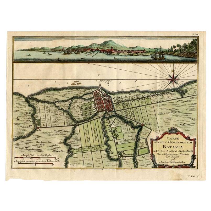
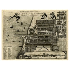
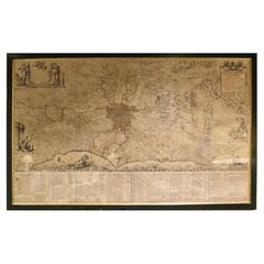
Antique map titled 'Carte des Environs de Batavia'. Map of the environs of Batavia (now Jakarta), Indonesia. This print originates from volume 8 of 'Histoire générale des voyages'. Published by Didot, 1750.
- Dimensions:Height: 9.85 in (25 cm)Width: 15.16 in (38.5 cm)Depth: 0.02 in (0.5 mm)
- Materials and Techniques:
- Period:
- Date of Manufacture:1750
- Condition:Original folding lines. General age-related toning, blank verso. Small hole outside image. Please study images carefully.
- Seller Location:Langweer, NL
- Reference Number:Seller: BG-125691stDibs: LU3054320221912
About the Seller
5.0
Recognized Seller
These prestigious sellers are industry leaders and represent the highest echelon for item quality and design.
Platinum Seller
Premium sellers with a 4.7+ rating and 24-hour response times
Established in 2009
1stDibs seller since 2017
2,508 sales on 1stDibs
Typical response time: <1 hour
- ShippingRetrieving quote...Shipping from: Langweer, Netherlands
- Return Policy
Authenticity Guarantee
In the unlikely event there’s an issue with an item’s authenticity, contact us within 1 year for a full refund. DetailsMoney-Back Guarantee
If your item is not as described, is damaged in transit, or does not arrive, contact us within 7 days for a full refund. Details24-Hour Cancellation
You have a 24-hour grace period in which to reconsider your purchase, with no questions asked.Vetted Professional Sellers
Our world-class sellers must adhere to strict standards for service and quality, maintaining the integrity of our listings.Price-Match Guarantee
If you find that a seller listed the same item for a lower price elsewhere, we’ll match it.Trusted Global Delivery
Our best-in-class carrier network provides specialized shipping options worldwide, including custom delivery.More From This Seller
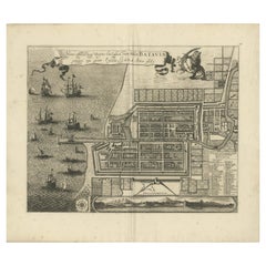
View AllAntique Map of Batavia, Capital of The Dutch East Indies at the Time, 1751
Located in Langweer, NL
Antique map titled 'Carte von den Gegenden um Batavia ...' (Map of Batavia and surroundings.) This print shows a map and a view of Batavia, (Jakarta) Indones...
Category
Antique 18th Century Maps
Materials
Paper

$431 Sale Price
20% Off
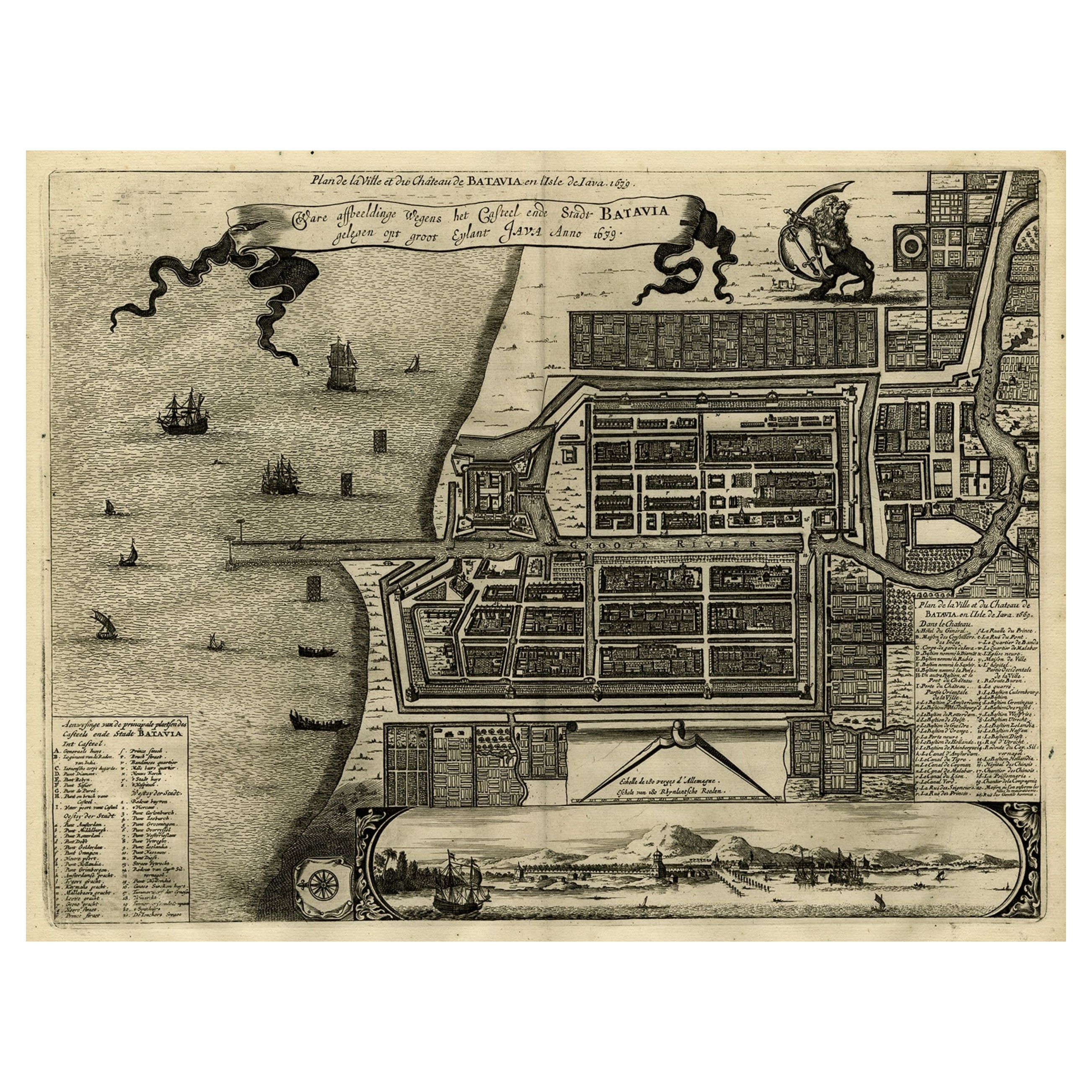
Antique Map of Batavia, Dutch East Indies, Nowadays Jakarta, Indonesia, ca.1669
Located in Langweer, NL
Antique map titled 'Ware afbeeldinge wegens het Casteel ende Stadt Batavia gelegen opt groot Eylant Java Anno 1679. Plan de la Ville et du Chateau de Batavia en l'Isle de Iava. 1679....
Category
Antique 1660s Maps
Materials
Paper
$1,294 Sale Price
20% Off
Antique Map of Batavia 'Jakarta, Indonesia', the Dutch East-Indies, 1782
Located in Langweer, NL
Antique map titled 'Batavia zo als het was in den Jaare 1731.' (Batavia as it was in the year 1731.) Map of the city of Batavia (Jakarta) in Indonesia. With legend and scale. This pr...
Category
Antique 18th Century Maps
Materials
Paper

$613 Sale Price
20% Off
Rare 1681 Map of Batavia: Detailed Dutch Colonial Era Cartography, 1681
Located in Langweer, NL
The map of Batavia (modern-day Jakarta) from 1681, attributed to Frederick de Wit holds significant historical importance for several reasons:
Historical Context
1. Colonial Era: This map dates back to the Dutch colonial era when Batavia served as the administrative and commercial hub of the Dutch East India Company (VOC). The VOC was a powerful trading entity that played a crucial role in the global spice trade and colonization in Southeast Asia.
2. Strategic Importance: Batavia was strategically located on the northwestern coast of Java, providing the Dutch with a critical base for their maritime operations. The city became the center of Dutch political and military control in the region.
Cartographic Significance
1. Detailed Urban Layout: The map meticulously details the layout of Batavia, including its fortifications, canals, streets, and significant buildings. This level of detail provides insights into the urban planning and architectural styles of the period.
2. Military Engineering: The fortifications shown on the map illustrate the advanced military engineering techniques used by the Dutch to protect their valuable colony. The walls, bastions, and moats indicate the strategic considerations taken to defend against potential invasions.
3. Maritime Activity: The depiction of ships in the harbor highlights Batavia's role as a major maritime center. The VOC's fleets were essential for trade routes connecting Europe, Africa, and Asia, making Batavia a crucial node in global commerce.
Artistic and Cultural Value
1. Artistic Elements: The decorative elements, such as the lion holding a shield and the intricate cartouches, reflect the artistic trends of Dutch Golden Age cartography. These embellishments were not only informative but also served to display the cartographer's skill and the map's prestige.
2. Cultural Exchange: Maps like this one provide evidence of cultural exchange between the Dutch and the indigenous populations of Java. The blending of Dutch and local influences can be seen in various aspects of the map and the architecture of the city.
Rarity and Preservation
1. Rarity: Maps from the 17th century, especially those in good condition, are relatively rare and highly valued by collectors and historians. Each map provides a unique snapshot of historical geography and urban development.
2. Preservation of History: This map serves as a historical document, preserving knowledge about Batavia's cityscape, infrastructure, and colonial governance. It helps historians and scholars understand the socio-economic and political dynamics of the period.
Conclusion
The map of Batavia from 1681 is special due to its detailed depiction of one of the most important colonial cities in Southeast Asia during the Dutch Golden Age. It reflects the strategic, economic, and cultural significance of Batavia, serving as a valuable resource for understanding the history of Dutch colonialism and its global impact. The map's artistry and precision make it an important artifact in the history of cartography.
---------------
The map is an original and historical map of Batavia (present-day Jakarta) on the island of Java, dated 1681. There are several details to consider when evaluating its origins and possible authorship:
1. **Style and Detail**: The intricate details and style are reminiscent of maps created by Frederick de Wit, a prominent Dutch cartographer and engraver of the 17th century. He was known for his detailed city maps and sea charts.
2. **Lack of Signature**: The absence of "F. de Wit, Excudit" could indicate either an omission or a different engraver. However, it is essential to note that some maps from that period were reproduced or copied by other engravers and cartographers. This was not uncommon, as map-making was a collaborative effort, and copies of popular maps were frequently made.
3. **Map Characteristics**:
- The depiction of ships and the detailed fortifications are typical of Dutch cartography in the late 17th century.
- The decorative elements, such as the lion holding a shield, are also characteristic of Dutch map engravers.
4. **Other Possible Engravers**: While Frederick de Wit is a strong candidate, other notable Dutch engravers from that period include Joan Blaeu and Willem Janszoon Blaeu. They also produced highly detailed maps and could potentially be the creators or inspirers of this map.
To determine the precise authorship, you might consider:
- **Comparing** this map with other confirmed works of Frederick de Wit and his contemporaries to identify stylistic similarities and differences.
- **Historical Records**: Consulting historical records or publications related to Dutch cartography in the 17th century might provide more context or even direct references to this particular map.
If you have access to additional details or higher-resolution images of specific sections, it might help further pinpoint the map's origin and authorship.
-------------
Frederick de Wit (1629–1706) was a prominent Dutch cartographer, engraver, and publisher known for his detailed and decorative maps, atlases, and globes. He played a significant role in the Dutch Golden Age of cartography, contributing to the wealth of geographic knowledge and artistic achievement during this period. Here are key aspects of his life and work:
### Biography
- **Early Life**: Frederick de Wit was born in Gouda, Netherlands, in 1629. Little is known about his early years, but he moved to Amsterdam, the epicenter of Dutch cartography, in the mid-17th century.
- **Career Beginnings**: De Wit began his career as an engraver and publisher, initially producing maps that were reissues of earlier works by other cartographers, such as Joan Blaeu and Willem Janszoon Blaeu.
### Contributions to Cartography
- **Mapmaking**: De Wit was known for his meticulous attention to detail and artistic flair. He produced a wide range of maps, including world maps, regional maps, city plans, and maritime charts...
Category
Antique 1680s Maps
Materials
Paper
$5,655 Sale Price
20% Off
Free Shipping
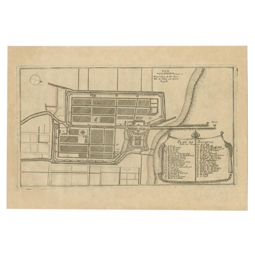
Antique Plan of Batavia in the Dutch East Indies or Indonesia, circa 1695
Located in Langweer, NL
Antique print titled 'Plan de Batavia'. Plan of Batavia, Jakarta, Indonesia. Oriented with north to the lower right by a simple compass rose. French title and key cartouche in drape form.
Artists and Engravers: Nicolas de Fer...
Category
Antique 17th Century Maps
Materials
Paper
$277 Sale Price
20% Off
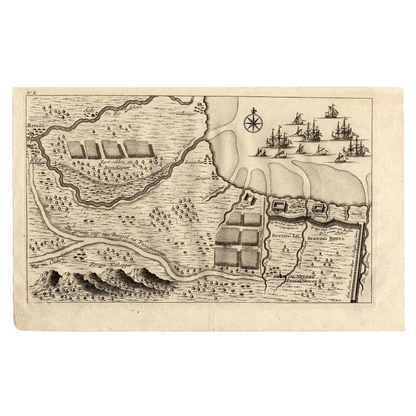
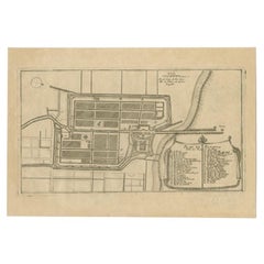
Antique Map of the Region of Pasuruan, Java, Indonesia, 1726
Located in Langweer, NL
"Map of the region around Pasuruan. It shows the location of rice fields, the village Bangil, as well as three places named Pagger (also Pagar), a cluster of buildings surrounded by a bamboo fence. The location of a earthen wall with pallisade and small cannons...
Category
Antique 18th Century Maps
Materials
Paper
You May Also Like
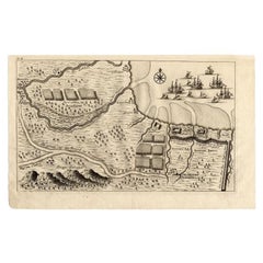
Rare Original Map of New Amsterdam (New York) – “Restitutio”, ca. 1674 –
Located in Dronten, NL
An exceptionally rare and original 17th-century engraving of New Amsterdam, now New York City, published by the renowned Amsterdam cartographer Carel (Carolus) Allard around 1674. Kn...
Category
Antique 17th Century Dutch Maps
Materials
Paper

1633 Map "La Souverainete De Sedan Et De Raucourt, Et La Prevoste Ric0011
Located in Norton, MA
1653 map entitled
"La Souverainete de Sedan et de Raucourt, et la Prevoste de Doncheri,"
Ric0011
Description:
Lovely map centered on Sedan and Doncheri and the Meuze River fr...
Category
Antique 17th Century Dutch Maps
Materials
Paper

1752 Vaugoundy Map of Flanders : Belgium, France, and the Netherlands, Ric.a002
Located in Norton, MA
Large Vaugoundy Map of Flanders:
Belgium, France, and the Netherlands
Colored -1752
Ric.a002
Description: This is a 1752 Didier Robert de Vaugondy map of Flanders. The map de...
Category
Antique 17th Century Unknown Maps
Materials
Paper

18th Century Map of Rome & Surrounding Vicinity
Located in New Orleans, LA
Intriguing framed map of Rome and the surrounding vicinity featuring detailed cartography, ornamental illustrations, and text index at the bottom. A great, historical conversation pi...
Category
Antique 18th Century Italian Antiquities
Materials
Paper
1627 Hendrik Hondius Map Entitled "Vltoniae Orientalis Pars, " Ric.a009
Located in Norton, MA
1627 Hendrik Hondius map entitled
"Vltoniae orientalis pars,"
Ric.a009
Title:
Vltoniae orientalis : pars
Title (alt.) :
Ultoniae orientalis pars
Creator:
Mercator, Gerh...
Category
Antique 17th Century Dutch Maps
Materials
Paper

Rare 18th C. Newport Map
Located in Sandwich, MA
Rare 18th C, Map titled "A plan of the town of Newport in the province of Rhode Island". Earliest printed plan of Newport, published for the use of the British just prior to their o...
Category
Antique 1770s American Maps
Materials
Paper

$19,500 / item
More Ways To Browse
Dutch East Indies
Antique Maps Indonesia
Indonesia Jakarta
Antique Maps Indonesia
Compass Rose Antique
Swiss Antiques And Collectables
Antique Compass Map
Blaeu Maps
Coat Of Arms German
Antique Collectables Australia
Military Map
Spanish Empire
Antique Maps Scotland
Mississippi Antique
Denmark Map
Antique Maps Of North America
Wine Map
Map Greece