Items Similar to Antique Map of the French Colony of Algeria by V. Levasseur, 1854


Want more images or videos?
Request additional images or videos from the seller
1 of 5
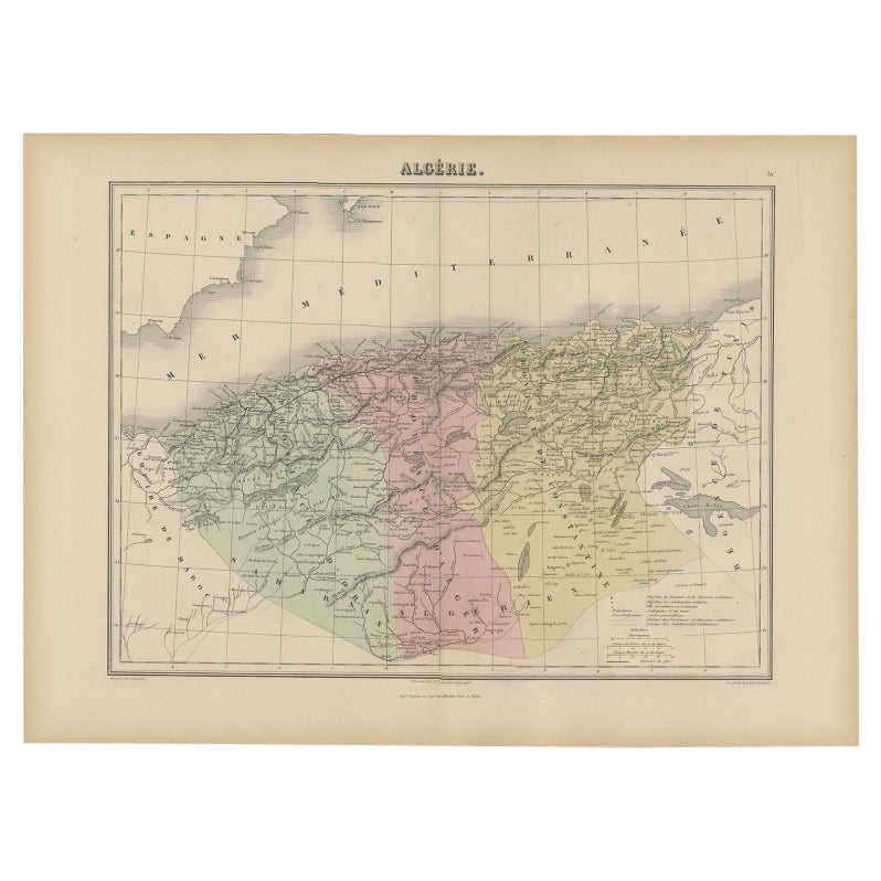
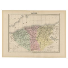
Antique Map of the French Colony of Algeria by V. Levasseur, 1854
$189.03
$236.2920% Off
£141.69
£177.1120% Off
€160
€20020% Off
CA$259.70
CA$324.6220% Off
A$289.93
A$362.4120% Off
CHF 151.92
CHF 189.9020% Off
MX$3,549.01
MX$4,436.2720% Off
NOK 1,929.36
NOK 2,411.7120% Off
SEK 1,819.15
SEK 2,273.9320% Off
DKK 1,217.98
DKK 1,522.4720% Off
About the Item
Antique map titled 'Algérie, Colonie Francaise'. Shows the region divided into the administrative provinces of Oban, Alger, and Constantine. The map proper is surrounded by elaborate decorative engravings designed to illustrate both the natural beauty and trade richness of the land. There is a short textual history of the region depicted to the left and right of the map. This map originates from ‘Atlas National de la France Illustré’. Published by A. Combette, Paris, 1854.
- Creator:Victor Levasseur (Artist)
- Dimensions:Height: 13.98 in (35.5 cm)Width: 20.67 in (52.5 cm)Depth: 0.02 in (0.5 mm)
- Materials and Techniques:
- Period:
- Date of Manufacture:1854
- Condition:General age-related toning. Please study image carefully.
- Seller Location:Langweer, NL
- Reference Number:Seller: BG-05614/61stDibs: LU3054310739043
Victor Levasseur
Victor Jules Levasseur (1795–1862) was a French cartographer widely known for his distinctive decorative style. He produced numerous maps more admired for the artistic content of the scenes and data surrounding the map than for the detail of the map. Victor Levasseur was born in 1795 in France. Little is known about his early life and education, but he emerged as one of the most prominent French cartographers of the 19th century. Levasseur lived during a time of significant political and geographical changes in France and Europe, which greatly influenced his work as a mapmaker.
About the Seller
5.0
Recognized Seller
These prestigious sellers are industry leaders and represent the highest echelon for item quality and design.
Platinum Seller
Premium sellers with a 4.7+ rating and 24-hour response times
Established in 2009
1stDibs seller since 2017
2,513 sales on 1stDibs
Typical response time: <1 hour
- ShippingRetrieving quote...Shipping from: Langweer, Netherlands
- Return Policy
Authenticity Guarantee
In the unlikely event there’s an issue with an item’s authenticity, contact us within 1 year for a full refund. DetailsMoney-Back Guarantee
If your item is not as described, is damaged in transit, or does not arrive, contact us within 7 days for a full refund. Details24-Hour Cancellation
You have a 24-hour grace period in which to reconsider your purchase, with no questions asked.Vetted Professional Sellers
Our world-class sellers must adhere to strict standards for service and quality, maintaining the integrity of our listings.Price-Match Guarantee
If you find that a seller listed the same item for a lower price elsewhere, we’ll match it.Trusted Global Delivery
Our best-in-class carrier network provides specialized shipping options worldwide, including custom delivery.More From This Seller
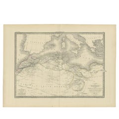
View AllAntique Map of Algeria and the French Colonies, 1875
Located in Langweer, NL
Antique map titled 'Algérie et Colonies Francaises'. Large map of Algeria and the French Colonies. This map originates from 'Atlas de Géographie Moderne Physique et Politique' by A. ...
Category
Antique Late 19th Century French Maps
Materials
Paper

$307 Sale Price
35% Off
Antique Map of Northern Africa by Perthes, 1848
Located in Langweer, NL
Antique map titled 'Africa Propria (..)'. Old map of North Africa and the region of Babylon originating from 'Orbis Terrarum Antiquus in usum Scholarum'. Artists and Engravers: Publi...
Category
Antique 19th Century Maps
Materials
Paper

$93 Sale Price
20% Off
French Antique Map of Northern Africa and Libya, c.1840
Located in Langweer, NL
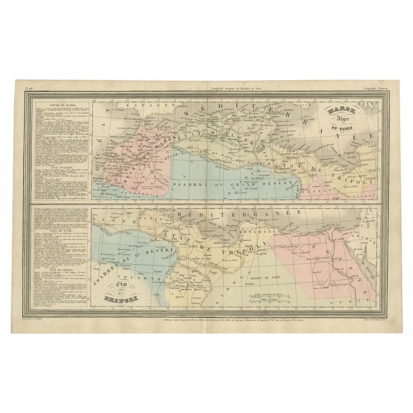
Antique map titled 'Marok, Alger et Tunis - Etat de Tripoli'. Map of Northern Africa and Libya. This map originates from 'Le globe Atlas classique Universel de géographie ancienne et...
Category
Antique 19th Century Maps
Materials
Paper

Antique Map of Algeria, 1880
Located in Langweer, NL
Antique map titled 'Algérie. Old map of Algeria. This map originates from 'Géographie Universelle Atlas-Migeon' by J. Migeon.
Artists and Engravers: Published by J. Migeon. Review...
Category
Antique 19th Century Maps
Materials
Paper
$207 Sale Price
20% Off
Antique Map of Northern Africa by Levasseur, '1875'
Located in Langweer, NL
Antique map titled 'Carte de l'Afrique Septentrionale'. Large map of Northern Africa. This map originates from 'Atlas de Géographie Moderne Physique et...
Category
Antique Late 19th Century Maps
Materials
Paper
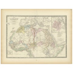
$378 Sale Price
20% Off
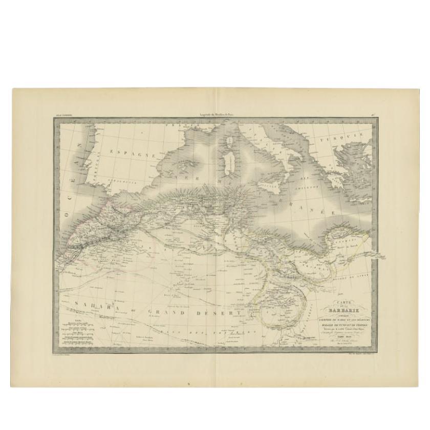
Antique Map of the Barbary Coast by Lapie, 1842
Located in Langweer, NL
Antique map titled 'Carte de la Barbarie contenant l'Empire de Maroc (..)'. Map of the Barbary Coast. This map originates from 'Atlas universel de géographie ancienne et moderne (..)...
Category
Antique 19th Century Maps
Materials
Paper
$230 Sale Price
20% Off
You May Also Like
Large Original Antique Map of Morocco. Edward Weller, 1861
Located in St Annes, Lancashire
Great map of Morocco
Lithograph engraving by Edward Weller
Original colour
Published, 1861
Unframed
Good condition.
Category
Antique 1860s English Victorian Maps
Materials
Paper

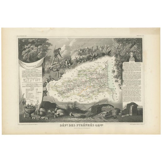
Pyrenees Orientales, France. Antique map of a French department, 1856
By Victor Levasseur
Located in Melbourne, Victoria
'Dept. des Pyrenees Orientales', steel engraving with original outline hand-colouring., 1856, from Levasseur's 'Atlas National Illustre'.
This area is well-known wine producing reg...
Category
19th Century Naturalistic Landscape Prints
Materials
Engraving

Original Antique Map of Africa by Dower, circa 1835
Located in St Annes, Lancashire
Nice map of Africa
Drawn and engraved by J.Dower
Published by Orr & Smith. C.1835
Unframed.
Free shipping
Category
Antique 1830s English Maps
Materials
Paper

Large Original Antique Map of Afghanistan. Edward Weller, 1861
Located in St Annes, Lancashire
Great map of Afghanistan
Lithograph engraving by Edward Weller
Original colour
Published, 1861
Unframed
Good condition
Category
Antique 1860s English Victorian Maps
Materials
Paper

Map of Campaign of 1814 - Etching by Pierre François Tardieu - 1837
Located in Roma, IT
Map of Campaign of 1814 is an Etching realized by Pierre François Tardieu in 1837.
Good conditions.
The artwork is realized in a well-balanced composition. the artwork and belongs ...
Category
1830s Modern Figurative Prints
Materials
Lithograph

Map of the Holy Land "Carte de la Syrie et de l'Egypte" by Pierre M. Lapie
By Pierre M. Lapie
Located in Alamo, CA
An early 19th century map of ancient Syria and Egypt entitled "Carte de la Syrie et de l'Egypte anciennes/dressée par M. Lapie, Colonel d'Etat Major, et...
Category
Antique Early 19th Century French Maps
Materials
Paper

More Ways To Browse
Map Of Britain
Map Of Africa
London Antique Maps
Sell Antiques
Antique World Globes
Used Law Office Furniture
Antique Map Of England
Antique Map Paris
Gold Maps
16th Century German
East India Company
China Map
17th Century World Map
Antique Maps Of Britain
Antique Furniture Edinburgh
Antique English Maps
Map Of India
British Empire Furniture