Items Similar to Antique Map of the French Province of Quercy, ca.1625
Want more images or videos?
Request additional images or videos from the seller
1 of 5
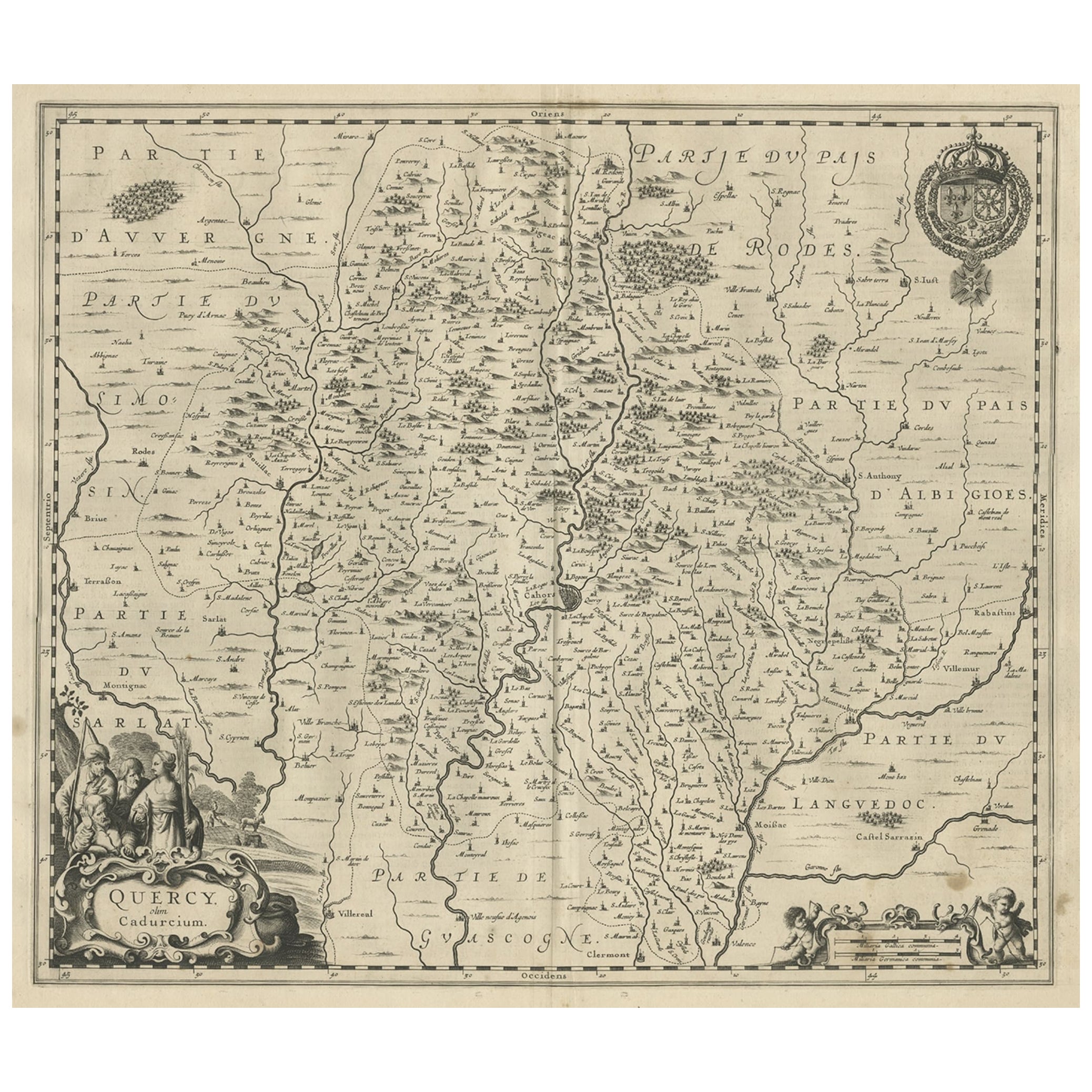
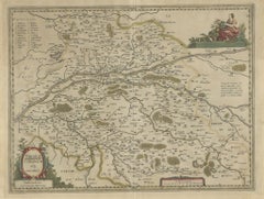
Antique Map of the French Province of Quercy, ca.1625
$407.37
£303.26
€340
CA$557.99
A$620.61
CHF 324.06
MX$7,552.17
NOK 4,138.79
SEK 3,881.45
DKK 2,588.30
Shipping
Retrieving quote...The 1stDibs Promise:
Authenticity Guarantee,
Money-Back Guarantee,
24-Hour Cancellation
About the Item
Antique map titled 'Quercy Cadurcium'. Old map of the region of Quercy, France. Quercy is a former province of France, the present-day department of Lot, the northern half of the department of Tarn-et-Garonne, and a few communities in the departments of Dordogne, Corrèze, and Aveyron.
Artists and Engravers: Gerard Mercator (Kremer) was born in Rupelmonde in Flanders and studied in Louvain. He drawn his first map in 1537 and became a cartographer and globe maker. In 1552 he moved to Duisburg, Germany where he published his famous 18-sheet world map in 1569 with his own new projection, today called Mercator projection. Later he decided to publish a new edition of Ptolemy's Geographia. Followed by his major work, a 3 volume collection of maps to which the word "Atlas" was applied the first time. The first volume was published 1585, followed by the second in 1589 and the third one after his death in 1595 by his son Rumold. A second edition of all three parts was published 1602. 1604 Jodocus Hondius acquired the plates and published several edition together with his sons Jodocus II and Henricus until 1633. More editions followed until 1666 by Janssonius who was in partnership with Henricus. Some of the plated where also used in W.J. Blaeu in 1630.
Condition: Fair, age-related toning. Latin text on verso. Repairs on folding line and margins. Also defects/ wear in image, please study image carefully.
Date: c.1625
Overall size: 56.5 x 46 cm.
Image size: 49.5 x 37.5 cm.
We sell original antique maps to collectors, historians, educators and interior decorators all over the world. Our collection includes a wide range of authentic antique maps from the 16th to the 20th centuries. Buying and collecting antique maps is a tradition that goes back hundreds of years. Antique maps have proved a richly rewarding investment over the past decade, thanks to a growing appreciation of their unique historical appeal. Today the decorative qualities of antique maps are widely recognized by interior designers who appreciate their beauty and design flexibility. Depending on the individual map, presentation, and context, a rare or antique map can be modern, traditional, abstract, figurative, serious or whimsical. We offer a wide range of authentic antique maps for any budget.
- Dimensions:Height: 18.12 in (46 cm)Width: 22.25 in (56.5 cm)Depth: 0 in (0.01 mm)
- Materials and Techniques:
- Period:
- Date of Manufacture:circa 1625
- Condition:Repaired: Repairs on folding line and margins. Condition: Fair, age-related toning. Latin text on verso. Repairs on folding line and margins. Also defects/ wear in image, please study image carefully.
- Seller Location:Langweer, NL
- Reference Number:Seller: BG-12389-61stDibs: LU3054327828022
About the Seller
5.0
Recognized Seller
These prestigious sellers are industry leaders and represent the highest echelon for item quality and design.
Platinum Seller
Premium sellers with a 4.7+ rating and 24-hour response times
Established in 2009
1stDibs seller since 2017
2,510 sales on 1stDibs
Typical response time: <1 hour
- ShippingRetrieving quote...Shipping from: Langweer, Netherlands
- Return Policy
Authenticity Guarantee
In the unlikely event there’s an issue with an item’s authenticity, contact us within 1 year for a full refund. DetailsMoney-Back Guarantee
If your item is not as described, is damaged in transit, or does not arrive, contact us within 7 days for a full refund. Details24-Hour Cancellation
You have a 24-hour grace period in which to reconsider your purchase, with no questions asked.Vetted Professional Sellers
Our world-class sellers must adhere to strict standards for service and quality, maintaining the integrity of our listings.Price-Match Guarantee
If you find that a seller listed the same item for a lower price elsewhere, we’ll match it.Trusted Global Delivery
Our best-in-class carrier network provides specialized shipping options worldwide, including custom delivery.More From This Seller
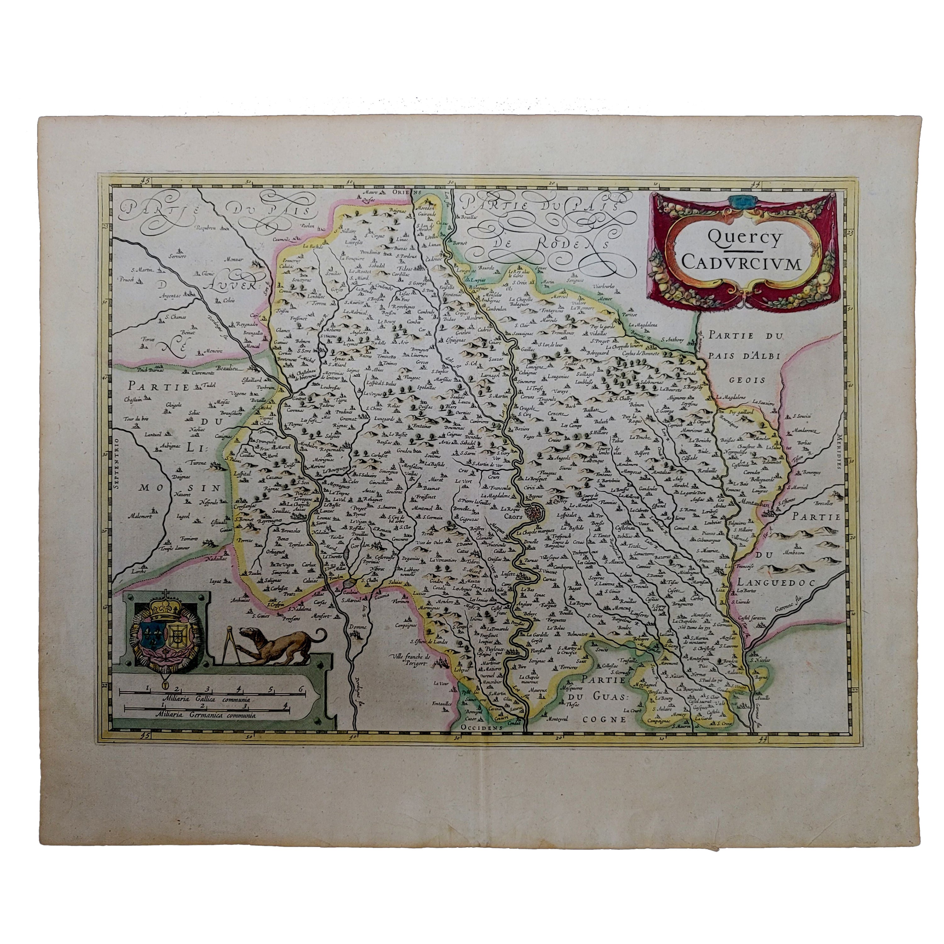
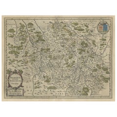
View AllDecorative Antique Map of the Quercy Region in France, 1657
Located in Langweer, NL
Antique map of France titled 'Quercy olim Cadurcium'.
Decorative map of the Quercy region. Quercy is a former province of France located in the country's southwest, bounded on th...
Category
Antique 1650s Maps
Materials
Paper
$536 Sale Price
20% Off
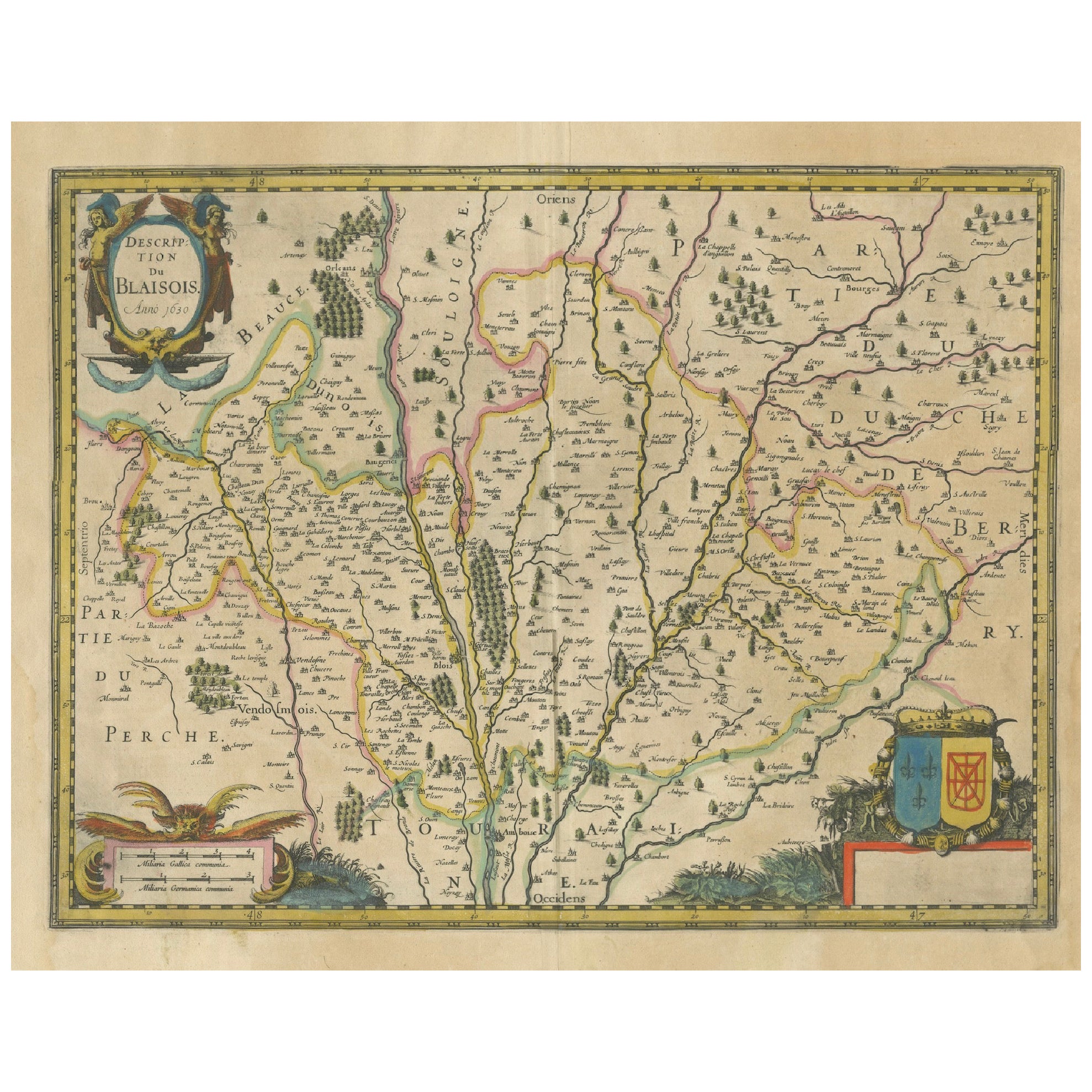
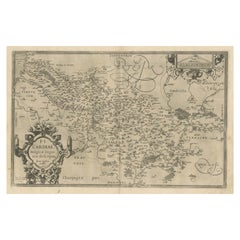
Map of Blaisois by Janssonius, 1633, Decorative Antique Map of Loire Valley
Located in Langweer, NL
Map of Blaisois by Janssonius, 1633, Decorative Antique Map of Loire Valley
This finely detailed and colorfully embellished map titled 'Description du Blaisois' was published in 163...
Category
Antique 1630s Maps
Materials
Paper
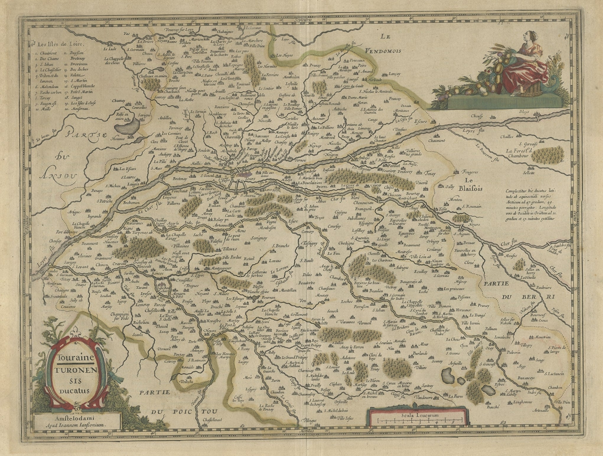
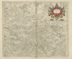
Antique Map of the Region of Touraine in France by Janssonius, 1657
By Johannes Janssonius
Located in Langweer, NL
Antique map titled 'Touraine - Turonensis Ducatus'.
Decorative map of the Touraine region. This map originates from 'Atlas Novus, Sive Theatrum Orbis Orbis Terrarum: In quo Galli...
Category
Antique 17th Century Maps
Materials
Paper
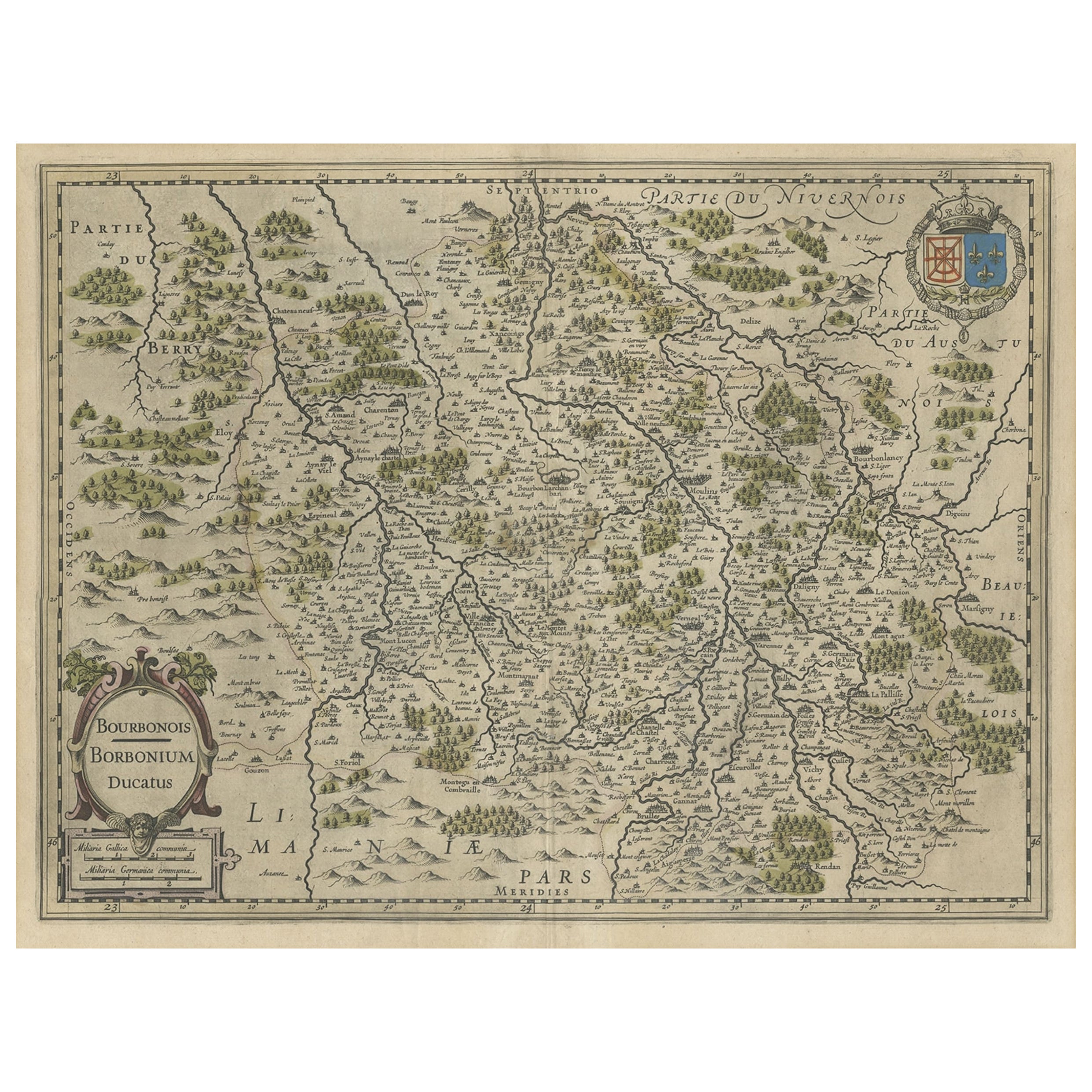
Old Map of the Bourbonnais Region of France, ca.1630
Located in Langweer, NL
Antique map titled 'Bourbonois - Borbonium Ducatus'.
Old map of the Bourbonnais region of France. Bourbonnais was a historic province in the centre of France that corresponds to ...
Category
Antique 1630s Maps
Materials
Paper
$603 Sale Price
20% Off
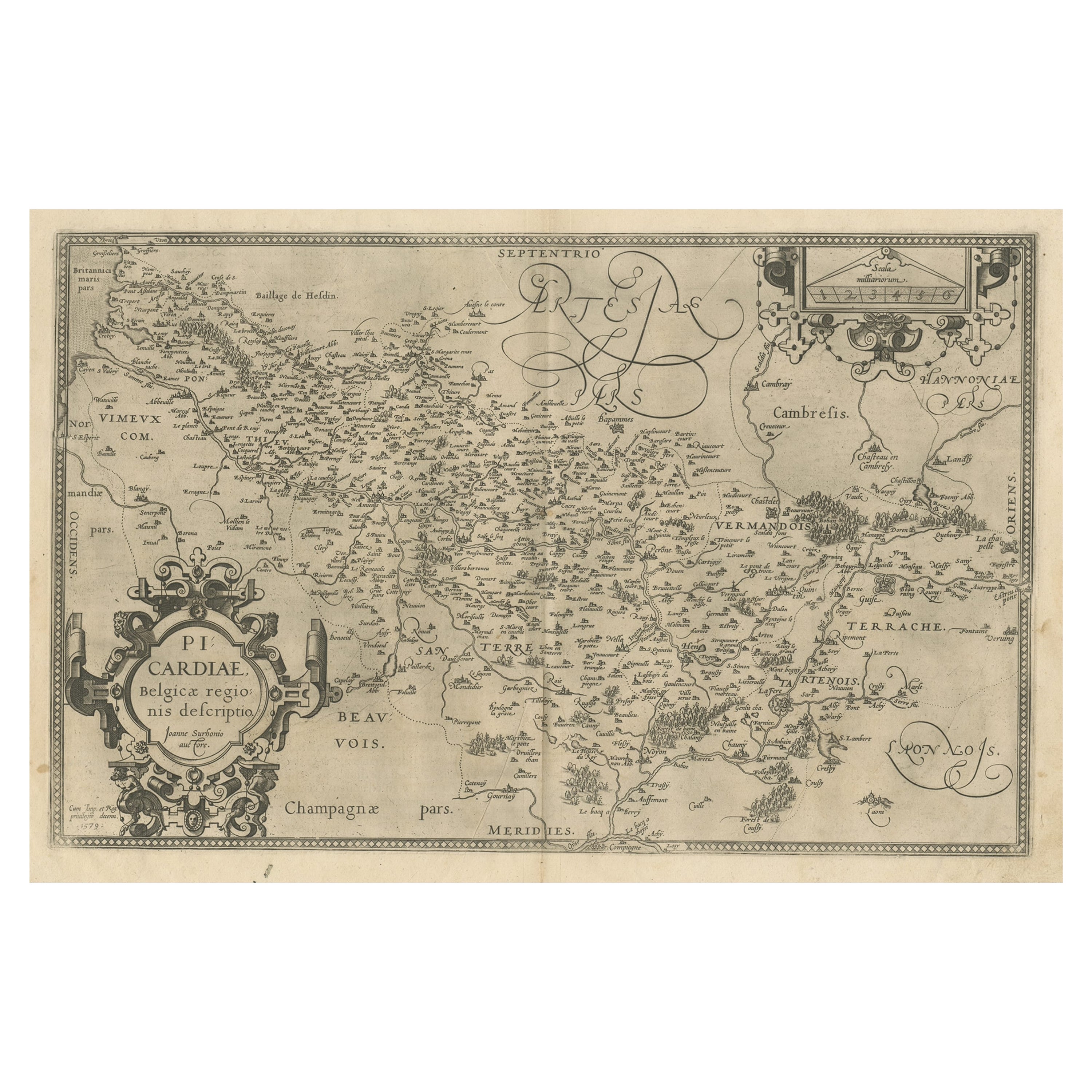
Original Antique Map of the Region of Picardy, France, ca.1602
Located in Langweer, NL
Antique map titled 'Picardiae Belgicae regionis descriptio'.
Original antique map of the region of Picardy, France. Superb example of the decorative style of Ortelius and filled ...
Category
Antique Early 1600s Maps
Materials
Paper
$623 Sale Price
20% Off
Antique Map of the Lower Alsace Region of France by Mapmaker Hondius, c.1630
Located in Langweer, NL
Antique map titled 'Alsatia Inferior'. Original antique map of the northern Alsace (Elzas) region of France. The map is centered on the course of the Rhine River, with Strasbourg at ...
Category
Antique 17th Century Maps
Materials
Paper
You May Also Like
1625 Mercator Map of the Provenience of Quercy, "Quercy Cadvrcivm Ric.0013
Located in Norton, MA
1625 Mercator map of the provenience of Quercy, entitled
"Quercy Cadvrcivm,"
Ric.0013
" Authentic" - Map of the provenience of Quercy Cadvrcivm
D...
Category
Antique 17th Century French Maps
Materials
Paper

The Loire Valley of France: A 17th C. Hand-colored Map by Sanson and Jaillot
By Nicholas Sanson d'Abbeville
Located in Alamo, CA
This large 17th century copper plate hand-colored engraved map entitled "Gouvernement D'Orleans et la Generalite divisee en ses Elections Par...
Category
1690s Landscape Prints
Materials
Engraving

1640 Joan Bleau Map Entitled"Diocecese de rheims et le pais de rethel, " Eic.a011
Located in Norton, MA
1640 Joan Bleau map entitled
"Diocecese de rheims et le pais de rethel,"
Ric.a011
OAN BLAEU
Diocecese de Rheims, et le pais de Rethel.
Handcolored engraving, c.1640.
...
Category
Antique 17th Century Dutch Maps
Materials
Paper

1656 Jansson Map Metz Region of France Entitled "Territorium Metense" Ric0014
Located in Norton, MA
1656 Jansson map Metz Region of France entitled "Territorium Metense."
Ric0014
" Authentic" - Map of the historical region surrounding Metz, in Lorraine, France.
Oriented with ...
Category
Antique 17th Century Dutch Maps
Materials
Paper

1590 Mercator Map Entitled "France Picardie Champaigne, Ric.0001
Located in Norton, MA
Description: Published in Amsterdam by Mercator/Hondius ca. 1590.
Ric.0001
Artists and Engravers: Map : 'France Picardie Champaigne cum regionibus adiacentibus'. (Map of the french provinces of Picardie and Champagne.) Copper engraved map of the french provinces of Picardie and Champagne, showing the cities of Caen, Paris, Melun, Auxerre, Verdun, etc. Copperplate engraving on verge type hand laid paper with watermark. Description: Published in Amsterdam by Mercator/Hondius ca. 1600.Artists and Engravers: Mercator was born in Rupelmonde in Flanders and studied in Louvain under Gemma Frisius, Dutch writer, astronomer and mathematician. The excellence of his work brought him the patronage of Charles V, but in spite of his favor with the Emperor he was caught up in the persecution of Lutheran protestants and charged with heresy, fortunately without serious consequences. No doubt the fear of further persecution influenced his move in 1552 to Duisburg, where he continued the production of maps, globes and instruments. Mercator's sons and grandsons, were all cartographers and made their contributions in various ways to his atlas. Rumold, in particular, was responsible for the complete edition in 1595. The map plates...
Category
Antique 16th Century Dutch Maps
Materials
Paper

1630 Pierre Petit map "Description du Gouvernement de la Capelle" Ric0010
Located in Norton, MA
1630 Pierre Petit map entitled
"Description du Gouvernement de la Capelle,"
Ric0010
Pierre Petit was the son of a minor provincial official in Montluçon. The town, in the Auver...
Category
Antique 17th Century Dutch Maps
Materials
Paper

More Ways To Browse
Antique Furniture Kingston
Antique Louisiana Map
Armenia Map
L Tardieu
Chinese Wall Pocket
18th Century Nautical Engraving
Antique Map Burgundy
Antique Map By Coronelli
Antique Maps Singapore
Constantinople Map
Iraq Map
Mughal Map
Map Of Palestine
Victorian Portico
Antique Furniture Dundee
Antique Map Iceland
Antique Maps Of Malta
Antique Saudi Arabia