Items Similar to Antique Map of Friesland in the Netherlands, 1770


Want more images or videos?
Request additional images or videos from the seller
1 of 5
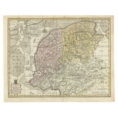
Antique Map of Friesland in the Netherlands, 1770
$144.12
$180.1520% Off
£106.14
£132.6820% Off
€120
€15020% Off
CA$196.06
CA$245.0820% Off
A$217.87
A$272.3320% Off
CHF 114.17
CHF 142.7120% Off
MX$2,671.76
MX$3,339.7020% Off
NOK 1,456.11
NOK 1,820.1420% Off
SEK 1,369.85
SEK 1,712.3220% Off
DKK 913.54
DKK 1,141.9320% Off
Shipping
Retrieving quote...The 1stDibs Promise:
Authenticity Guarantee,
Money-Back Guarantee,
24-Hour Cancellation
About the Item
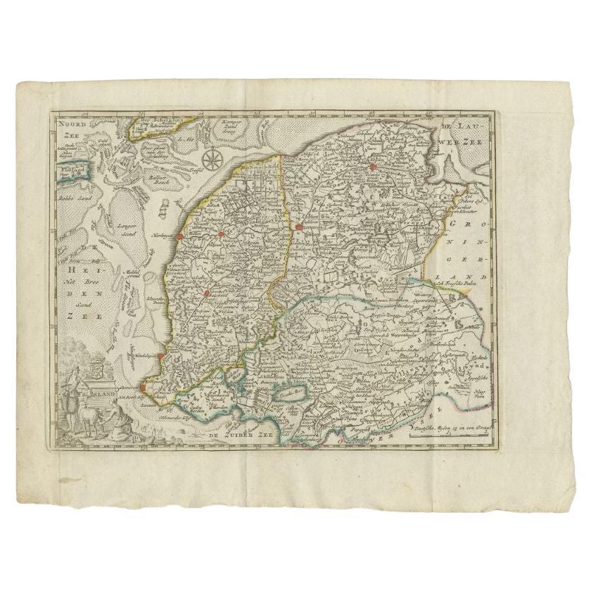
Antique map titled 'De Synode van Friesland, in VI Klassen verdeeld door W.A. Bachiene?. Map of the province of Friesland, the Netherlands. This map originates from 'Nieuwe kerkelyke geographische zak- en reisatlas der Vereenigde Nederlanden'. Artists and Engravers: Jan van Jagen (1709-1800) was a famous Dutch engraver and cartographer, often employed in Amsterdam. Van Jagen worked alone or together with other engravers/artists and produced multiple maps of the Netherlands, France, Palestine and other countries.
Artist: Jan van Jagen (1709-1800) was a famous Dutch engraver and cartographer, often employed in Amsterdam. Van Jagen worked alone or together with other engravers/artists and produced multiple maps of the Netherlands, France, Palestine and other countries.
Condition: Fair, original folding lines (with repairs). Repaired tear near 'Drachten'. Blank verso, please study image carefully.
Date: 1770
Overall size: 30 x 25 cm.
Image size: 27 x 21.5 cm.
We sell original antique maps to collectors, historians, educators and interior decorators all over the world. Our collection includes a wide range of authentic antique maps from the 16th to the 20th centuries. Buying and collecting antique maps is a tradition that goes back hundreds of years. Antique maps have proved a richly rewarding investment over the past decade, thanks to a growing appreciation of their unique historical appeal. Today the decorative qualities of antique maps are widely recognized by interior designers who appreciate their beauty and design flexibility. Depending on the individual map, presentation, and context, a rare or antique map can be modern, traditional, abstract, figurative, serious or whimsical. We offer a wide range of authentic antique maps for any budget.
- Dimensions:Height: 9.85 in (25 cm)Width: 11.82 in (30 cm)Depth: 0 in (0.01 mm)
- Materials and Techniques:
- Period:
- Date of Manufacture:1770
- Condition:
- Seller Location:Langweer, NL
- Reference Number:Seller: PCT-10451stDibs: LU3054326282292
About the Seller
5.0
Recognized Seller
These prestigious sellers are industry leaders and represent the highest echelon for item quality and design.
Platinum Seller
Premium sellers with a 4.7+ rating and 24-hour response times
Established in 2009
1stDibs seller since 2017
2,494 sales on 1stDibs
Typical response time: 1 hour
- ShippingRetrieving quote...Shipping from: Langweer, Netherlands
- Return Policy
Authenticity Guarantee
In the unlikely event there’s an issue with an item’s authenticity, contact us within 1 year for a full refund. DetailsMoney-Back Guarantee
If your item is not as described, is damaged in transit, or does not arrive, contact us within 7 days for a full refund. Details24-Hour Cancellation
You have a 24-hour grace period in which to reconsider your purchase, with no questions asked.Vetted Professional Sellers
Our world-class sellers must adhere to strict standards for service and quality, maintaining the integrity of our listings.Price-Match Guarantee
If you find that a seller listed the same item for a lower price elsewhere, we’ll match it.Trusted Global Delivery
Our best-in-class carrier network provides specialized shipping options worldwide, including custom delivery.More From This Seller
View AllAntique Map of Friesland, A Dutch Province, c.1780
Located in Langweer, NL
Antique map titled 'Dominii Frisiae (..)'. Original antique map of Friesland. 3rd state, most likely published after 1775 (De Rijke, 46.3). Artists and Engravers: Published by P. Sch...
Category
Antique 18th Century Maps
Materials
Paper

$912 Sale Price
20% Off
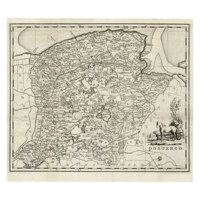
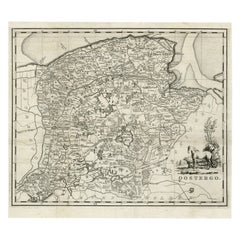
Antique Map of Oostergo, Friesland by Tirion, 1785
Located in Langweer, NL
Antique map Friesland titled 'Oostergo'. Antique map of part of Friesland depicting the 'Oostergo' region. Decorative titled cartouche with horse and plough. Originates from 'Tegenwo...
Category
Antique 18th Century Maps
Materials
Paper
$180 Sale Price
20% Off
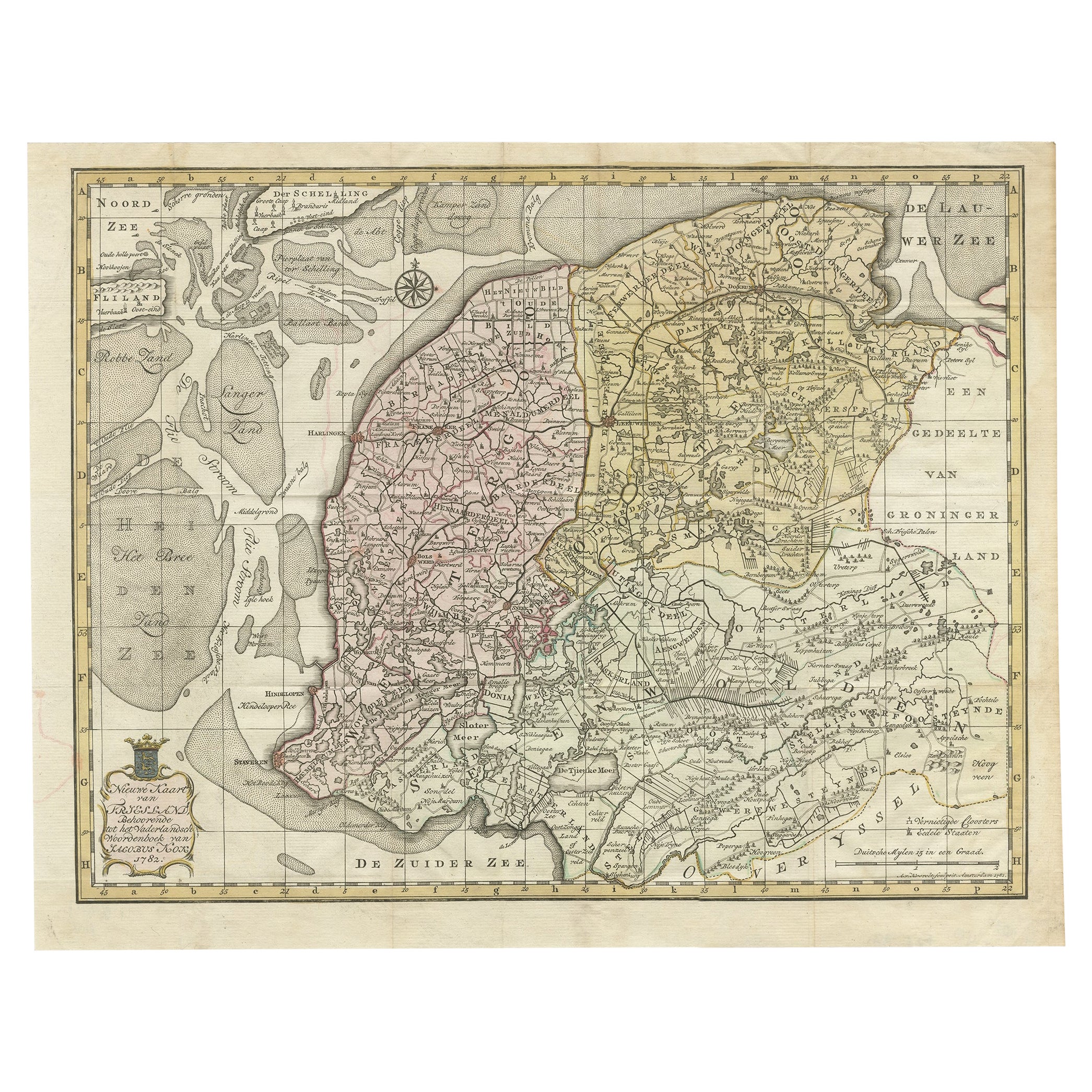
Antique Map of Province Friesland, The Netherlands, 1787
Located in Langweer, NL
Antique map titled 'Nieuwe Kaart van Friesland behoorende tot het Vaderlandsch Woordenboek van Jacobus Kok'. Original antique map of the province of Friesland, the Netherlands. This ...
Category
Antique 18th Century Maps
Materials
Paper
$411 Sale Price
20% Off
Antique Map of the Province of Friesland by Keizer & De Lat, 1788
Located in Langweer, NL
Antique map titled 'Friesland'. Uncommon antique map of the province of Friesland, the Netherlands. This map originates from 'Nieuwe Natuur- Geschied- en Handelkundige Zak- en Reisat...
Category
Antique 18th Century Maps
Materials
Paper
$211 Sale Price
20% Off
Antique Map of the Province of Friesland in The Netherlands, 1718
Located in Langweer, NL
Antique map titled 'Frisiae Dominium vernacule Friesland (..)'.
Original antique map of Friesland, the Netherlands. Originates from 'Uitbeelding van de Heerlijkheid van Friesland...
Category
Antique 18th Century Maps
Materials
Paper

$718 Sale Price
20% Off
Antique Map of Overijssel by Van Jagen, 1771
Located in Langweer, NL
Antique map titled 'L'Over-Issel'. This map depicts the Dutch province Overijssel. This map originates from 'Nouvel Atlas, très exact et fort commode pour toutes sortes de personnes,...
Category
Antique 18th Century Maps
Materials
Paper

$182 Sale Price
20% Off
You May Also Like
1752 Vaugoundy Map of Flanders : Belgium, France, and the Netherlands, Ric.a002
Located in Norton, MA
Large Vaugoundy Map of Flanders:
Belgium, France, and the Netherlands
Colored -1752
Ric.a002
Description: This is a 1752 Didier Robert de Vaugondy map of Flanders. The map de...
Category
Antique 17th Century Unknown Maps
Materials
Paper

1643 Willem&Joan Blaeu Map NW Flanders "Flandriae Teutonicae Pars Prientalior
Located in Norton, MA
1643 Willem and Joan Blaeu map of northwest Flanders, entitled
"Flandriae Teutonicae Pars Prientalior,"
Ric0012
" Authentic" - Map of the northwest Fl...
Category
Antique 17th Century Dutch Maps
Materials
Paper

1635 Willem Blaeu Map of Northern France"Comitatvs Bellovacvm" Ric.a08
Located in Norton, MA
1635 Willem Blaeu map of northern France, entitled.
"Comitatvs Bellovacvm Vernacule Beavvais,"
Colored
Ric.a008
“COMITATVS BELLOVACVM…” Amsterdam: W...
Category
Antique 17th Century Unknown Maps
Materials
Paper

1657 Janssonius Map of Vermandois and Cappelle, Ric. A-004
Located in Norton, MA
1657 Janssonius map of
Vermandois and Cappelle
Ric.a004
Description: Antique map of France titled 'Descriptio Veromanduorum - Gouvernement de la Cappelle'. Two detailed maps o...
Category
Antique 17th Century Unknown Maps
Materials
Paper

Prussia, Poland, N. Germany, Etc: A Hand-colored 17th Century Map by Janssonius
By Johannes Janssonius
Located in Alamo, CA
This is an attractive hand-colored copperplate engraved 17th century map of Prussia entitled "Prussia Accurate Descripta a Gasparo Henneberg Erlichensi", published in Amsterdam by Joannes Janssonius in 1664. This very detailed map from the golden age of Dutch cartography includes present-day Poland, Latvia, Lithuania, Estonia and portions of Germany. This highly detailed map is embellished by three ornate pink, red, mint green and gold...
Category
Antique Mid-17th Century Dutch Maps
Materials
Paper

1620 Map of Artois Entitled "Artesia Comitatvs Artois, " by Bleau, Ric.a012
Located in Norton, MA
1640 map of Artois entitled
"Artesia Comitatvs Artois,"
by Bleau
Colored
A-012.
Detailed map of the northern province of Artois, France on the border with Belgium. Feature...
Category
Antique 17th Century Dutch Maps
Materials
Paper

More Ways To Browse
Jans Antiques
Map Of Palestine
Antique Map Palestine
Relief Map
Antique Map Of Venice
Antique Map Of Georgia
Antique Nautical Charts
Hand Painted Antique Map
Antique Maps New Zealand
Antique Maps Persia
Map Railroad
Mariner Furniture
Vintage Glass Map
Antique Furniture Cyprus
Antique Linen Map
Caribbean Colonial Furniture
Antique Maps West Indies
California Island Map