Items Similar to Antique Map of the Gaspar Strait by Huddart, '1788'


Want more images or videos?
Request additional images or videos from the seller
1 of 5
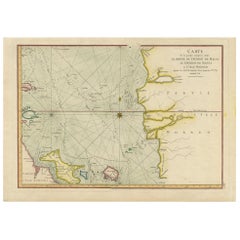
Antique Map of the Gaspar Strait by Huddart, '1788'
$785.48
$1,122.1230% Off
£590.17
£843.1030% Off
€665
€95030% Off
CA$1,081.61
CA$1,545.1630% Off
A$1,210.53
A$1,729.3230% Off
CHF 633.67
CHF 905.2430% Off
MX$14,705.70
MX$21,008.1530% Off
NOK 8,045.97
NOK 11,494.2430% Off
SEK 7,592.74
SEK 10,846.7730% Off
DKK 5,061.31
DKK 7,230.4430% Off
About the Item
Antique map titled 'Sketch of the Straits of Gaspar'. Detailed sea chart of the Gaspar Strait, showing part of the Island of Banca on the east coast of Sumatra just to the south of Singapore. The Gaspar Strait is a strait separating the Indonesian islands Belitung and Bangka and connecting the Java Sea to the South China Sea. Also includes Salt Island, Middle Island and part of Long Island. Originates from 'East India Pilot' by Laurie & Whittle. Engraved by J. Huddart, 1788.
- Dimensions:Height: 30.71 in (78 cm)Width: 22.25 in (56.5 cm)Depth: 0.02 in (0.5 mm)
- Materials and Techniques:
- Period:
- Date of Manufacture:1788
- Condition:Central horizontal fold as issued, minor offsetting and surface dirt, possibly erroneous manuscript ink annotation to lower edge that reads 'Printed for Robert Sayer (..)'. Minor wear, blank verso. Please study images carefully.
- Seller Location:Langweer, NL
- Reference Number:Seller: BG-127641stDibs: LU3054321908802
About the Seller
5.0
Recognized Seller
These prestigious sellers are industry leaders and represent the highest echelon for item quality and design.
Platinum Seller
Premium sellers with a 4.7+ rating and 24-hour response times
Established in 2009
1stDibs seller since 2017
2,535 sales on 1stDibs
Typical response time: <1 hour
- ShippingRetrieving quote...Shipping from: Langweer, Netherlands
- Return Policy
Authenticity Guarantee
In the unlikely event there’s an issue with an item’s authenticity, contact us within 1 year for a full refund. DetailsMoney-Back Guarantee
If your item is not as described, is damaged in transit, or does not arrive, contact us within 7 days for a full refund. Details24-Hour Cancellation
You have a 24-hour grace period in which to reconsider your purchase, with no questions asked.Vetted Professional Sellers
Our world-class sellers must adhere to strict standards for service and quality, maintaining the integrity of our listings.Price-Match Guarantee
If you find that a seller listed the same item for a lower price elsewhere, we’ll match it.Trusted Global Delivery
Our best-in-class carrier network provides specialized shipping options worldwide, including custom delivery.More From This Seller
View AllAntique Map of Quinam and the Côn ?ao Islands by Sayer, 1778
Located in Langweer, NL
Antique map titled 'A Chart of a part of the Coast of Cochinchina' and 'Plan of Pulo Condor'. Two maps on one sheet. The upper map shows part of the coast of Cochinchina from Cham Co...
Category
Antique 18th Century Maps
Materials
Paper

$311 Sale Price
20% Off
Antique Map of the Bay and Rocks of Petatlan by Anson, 1749
Located in Langweer, NL
Antique map titled 'Baye et Rochers de Petaplan (..) - De Baay en de Rotsen van Petaplan (..)'. Original antique map of the bay and rocks of Petatlan, Mexico. This map originates fro...
Category
Antique 18th Century Maps
Materials
Paper
$151 Sale Price
20% Off
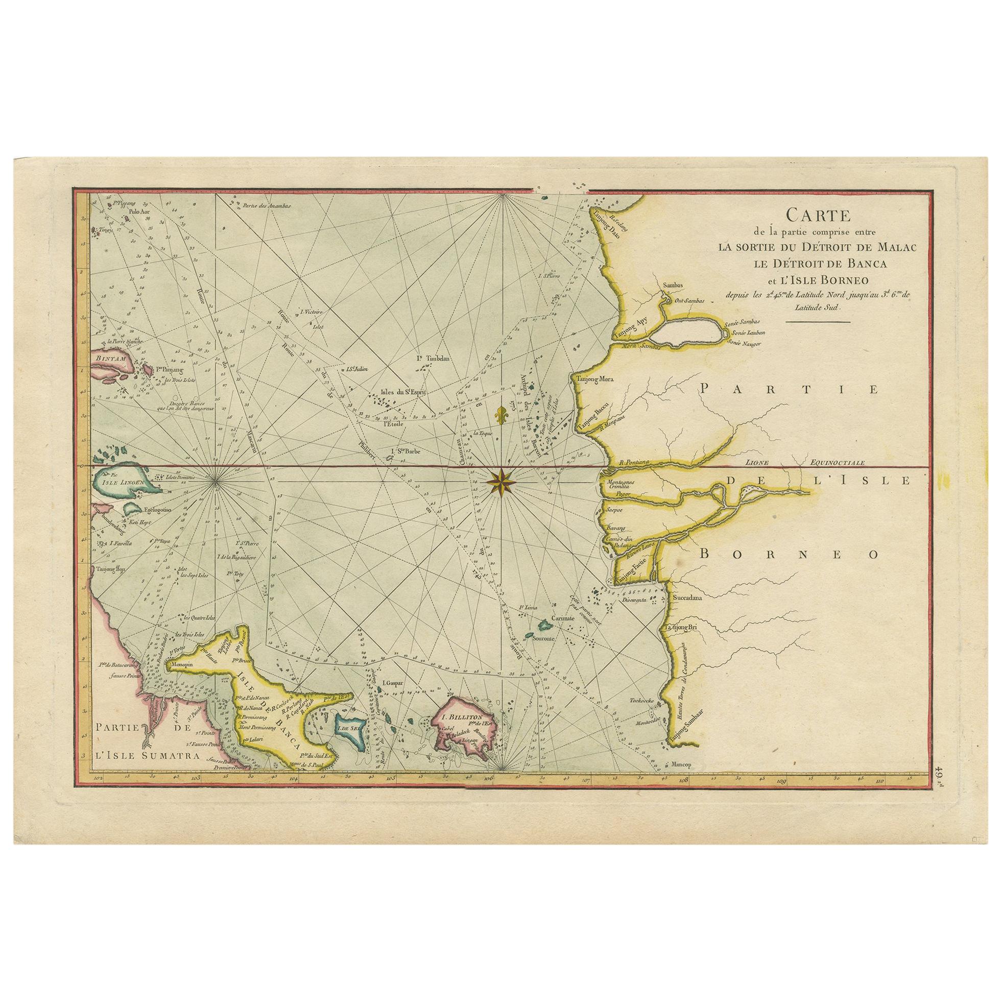
Antique Map of the Malacca and Bangka Strait by De Mannevillette '1775'
Located in Langweer, NL
Antique map titled 'Carte de la Partie Comprise entre la Sortie du Detroit de Malac Le Detroit de Banca et L’Isle Borneo'. Chart of the Strait of Malacca and Bangka Strait. It shows ...
Category
Antique Late 18th Century Maps
Materials
Paper
$1,133 Sale Price
20% Off
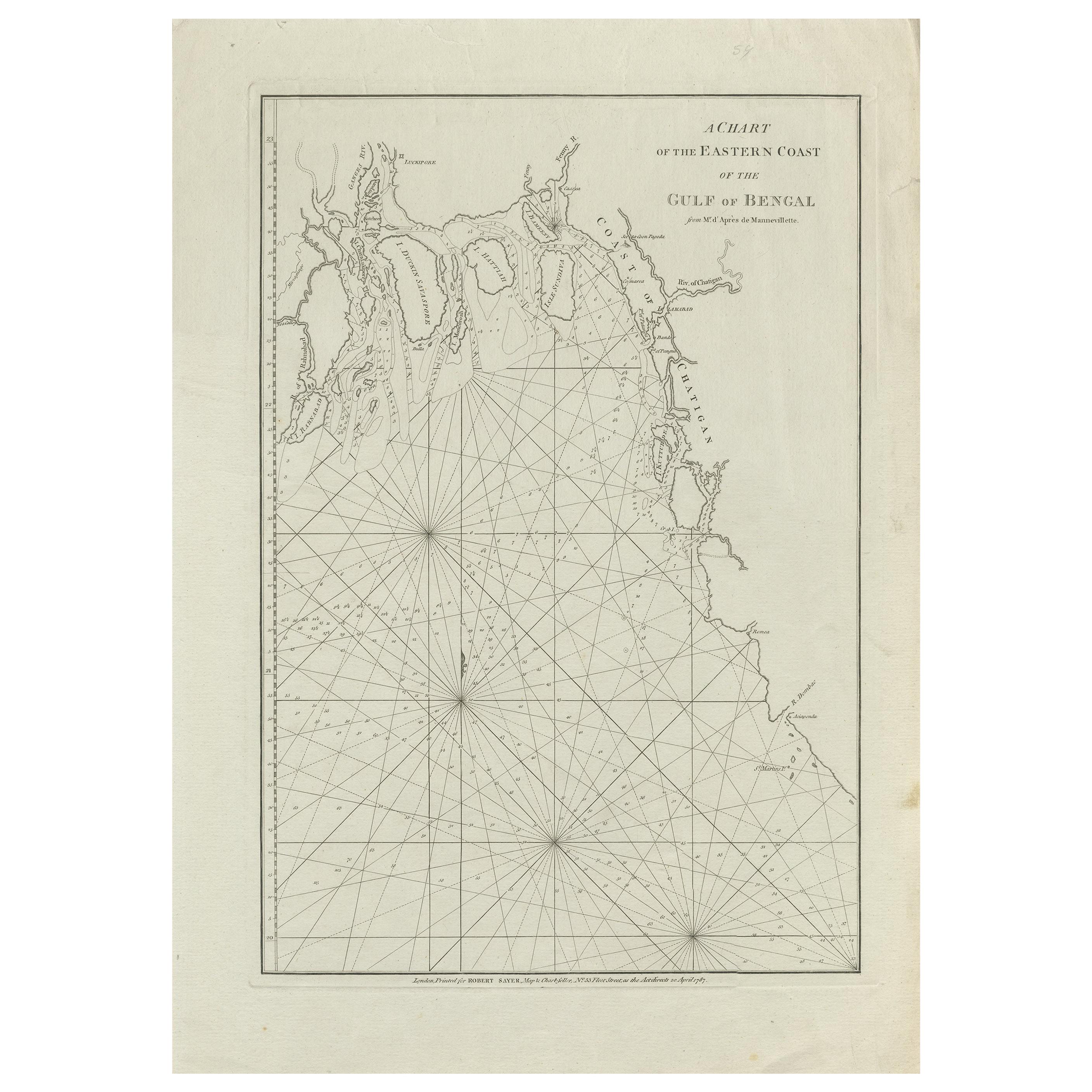
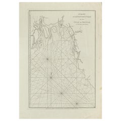
Antique Map of the Bay of Bengal Printed for Robert Sayer, 1787
Located in Langweer, NL
Antique map titled 'A Chart of the Eastern Coast of the Gulf of Bengal'. Original antique map of the Bay of Bengal. The Bay of Bengal is the northeastern...
Category
Antique Late 18th Century Maps
Materials
Paper
$472 Sale Price
20% Off
Antique Map of Juan Fernandez Island and Cumberland Bay, Chile - c. '1749'
Located in Langweer, NL
Antique map titled 'Plan de la Côte du N.E. de l 'Ile de Juan Fernandes - Schets van den Noord-Oost kant van het eiland Juan Fernandes '. This map depicts the northeast coast of the ...
Category
Antique Mid-18th Century Maps
Materials
Paper

$188 Sale Price
20% Off
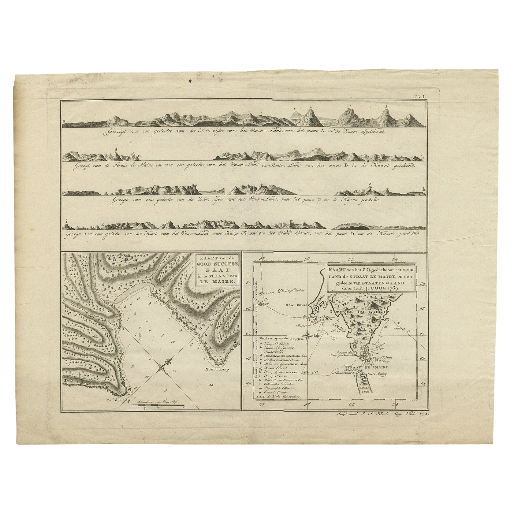
Antique Map of the Strait of Le Maire by Cook, 1803
Located in Langweer, NL
Antique map titled 'Kaart van de Good Success Baai in de Straat van Le Maire (..)'. Antique map of the Strait of Le Maire between Terra Fuego and Staten Island. On top, various coast...
Category
Antique 19th Century Maps
Materials
Paper

$595 Sale Price
20% Off
You May Also Like
Original Antique Map of South America. C.1780
Located in St Annes, Lancashire
Great map of South America
Copper-plate engraving
Published C.1780
Two small worm holes to left side of map
Unframed.
Category
Antique Early 1800s English Georgian Maps
Materials
Paper

Antique Lithography Map, Black Sea, English, Framed, Cartography, Victorian
Located in Hele, Devon, GB
This is an antique lithography map of the Black Sea region. An English, framed atlas engraving of cartographic interest by John Rapkin, dating to the early Victorian period and later...
Category
Antique Mid-19th Century British Early Victorian Maps
Materials
Wood

1814 Map of "Russian Empire" Ric.r032
Located in Norton, MA
1814 Map of
"Russian Empire"
Ric.r032
Russian Empire. Description: This is an 1814 John Thomson map of the Russian Empire. The map depicts the region from the Baltic Sea, Prussia, and Sweden to the Aleutian Islands and from the Arctic Ocean to the Yellow River. Highly detailed, myriad cities, towns, and villages are labeled throughout, including St. Petersburg, Moscow, Minsk, Kiev, and Kharkov. Rivers and mountain ranges are also identified, as are islands and numerous locations along the coastlines. It is important to note that the long-disputed sea between Korea and Japan is identified as the 'Sea of Japan.
Historical Context:
In 1815, Tsarist Russia emerged from the Napoleonic Wars economically insolvent and politically fearful of the Revolutionary fervor that had just swept through Europe. In order to shore up Russia's economic position, the Tsars began an aggressive series of expansions into the Caucuses and Central Asia that would vastly increase the landmass of the Russian Empire.
Publication History
Thomson maps are known for their stunning color, awe inspiring size, and magnificent detail. Thomson's work, including this map, represents some of the finest cartographic art...
Category
Antique 19th Century Unknown Maps
Materials
Paper

Von Reilly Map of the Russian Empire, 1796
Located in Savannah, GA
A map of the Russian Empire in Europe by Von Reilly. Published in Vienna, 1796.
32 inches wide by 24 ½ inches tall
Category
Antique 1790s Austrian Prints
Materials
Glass, Wood, Paper

Original Antique Map of The World by Thomas Clerk, 1817
Located in St Annes, Lancashire
Great map of The Eastern and Western Hemispheres
On 2 sheets
Copper-plate engraving
Drawn and engraved by Thomas Clerk, Edinburgh.
Published by Mackenzie And Dent, 1817
...
Category
Antique 1810s English Maps
Materials
Paper

Large Original Antique Map of The Pacific Ocean, Fullarton, C.1870
Located in St Annes, Lancashire
Great map of The Pacific Ocean
From the celebrated Royal Illustrated Atlas
Lithograph by Swanston. Original color.
Published by Fullarton,...
Category
Antique 1870s Scottish Maps
Materials
Paper

More Ways To Browse
Java Map
Antique Maps Of Long Island
Map Of Middle East
Antique Map Of Middle East
Map Of Singapore
Singapore Antique
Straits Chinese
Straits Chinese Furniture
Antique Maps Singapore
Framed World Map
Rare Compass
16th Century Scotland
Antique Wood Coat Of Arms
Antique Maps Australia
Antique Quadrant
Caribbean Antique Furniture
Antique Native American Collectibles
Turkey Map