Items Similar to Antique Map of the Malacca and Bangka Strait by De Mannevillette '1775'


Want more images or videos?
Request additional images or videos from the seller
1 of 5
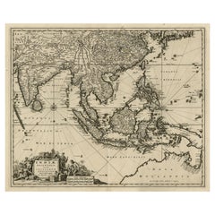
Antique Map of the Malacca and Bangka Strait by De Mannevillette '1775'
About the Item
Antique map titled 'Carte de la Partie Comprise entre la Sortie du Detroit de Malac Le Detroit de Banca et L’Isle Borneo'. Chart of the Strait of Malacca and Bangka Strait. It shows the west coast of Borneo, the islands of Belitung and Bangka, and part of the east coast of Sumatra. This map originates from 'Le Neptune Oriental' by Jean-Baptiste de Mannevillette. Published 1775.
- Dimensions:Height: 15.56 in (39.5 cm)Width: 21.66 in (55 cm)Depth: 0.02 in (0.5 mm)
- Materials and Techniques:
- Period:
- Date of Manufacture:1775
- Condition:General age-related toning. Minor wear, blank verso. Please study images carefully.
- Seller Location:Langweer, NL
- Reference Number:
About the Seller
5.0
Platinum Seller
These expertly vetted sellers are 1stDibs' most experienced sellers and are rated highest by our customers.
Established in 2009
1stDibs seller since 2017
1,928 sales on 1stDibs
Typical response time: <1 hour
- ShippingRetrieving quote...Ships From: Langweer, Netherlands
- Return PolicyA return for this item may be initiated within 14 days of delivery.
More From This SellerView All
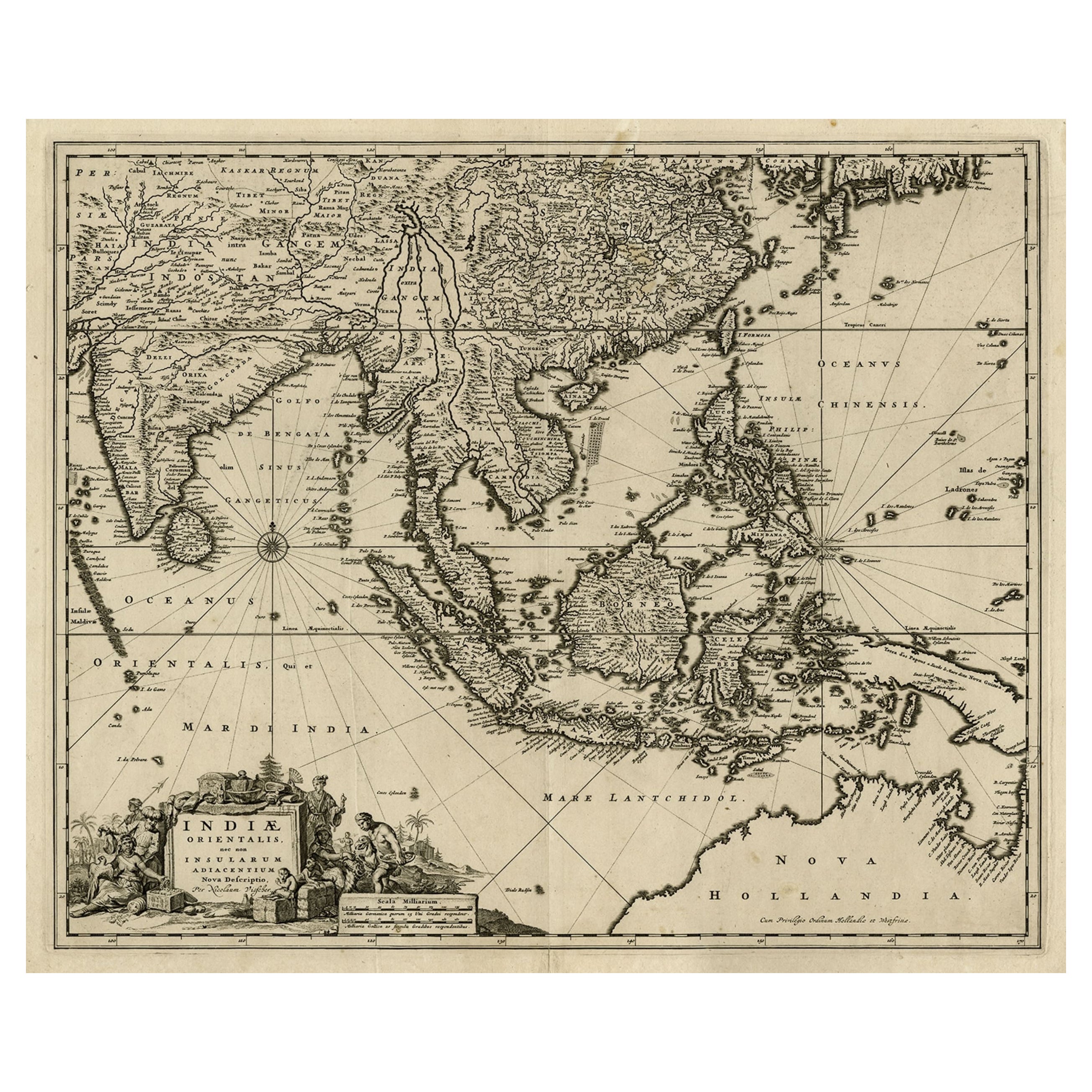
- Antique Map of the Strait of Malacca, Malay Peninsula & Dutch Indies, c.1670Located in Langweer, NLAntique map titled 'Indiae Orientalis, nec non Insularum Adiacentium Nova Descriptio.' Map of Southeast Asia. The map centers on the Strait of Malacca and Malay Peninsula. It ext...Category
Antique 1670s Maps
MaterialsPaper
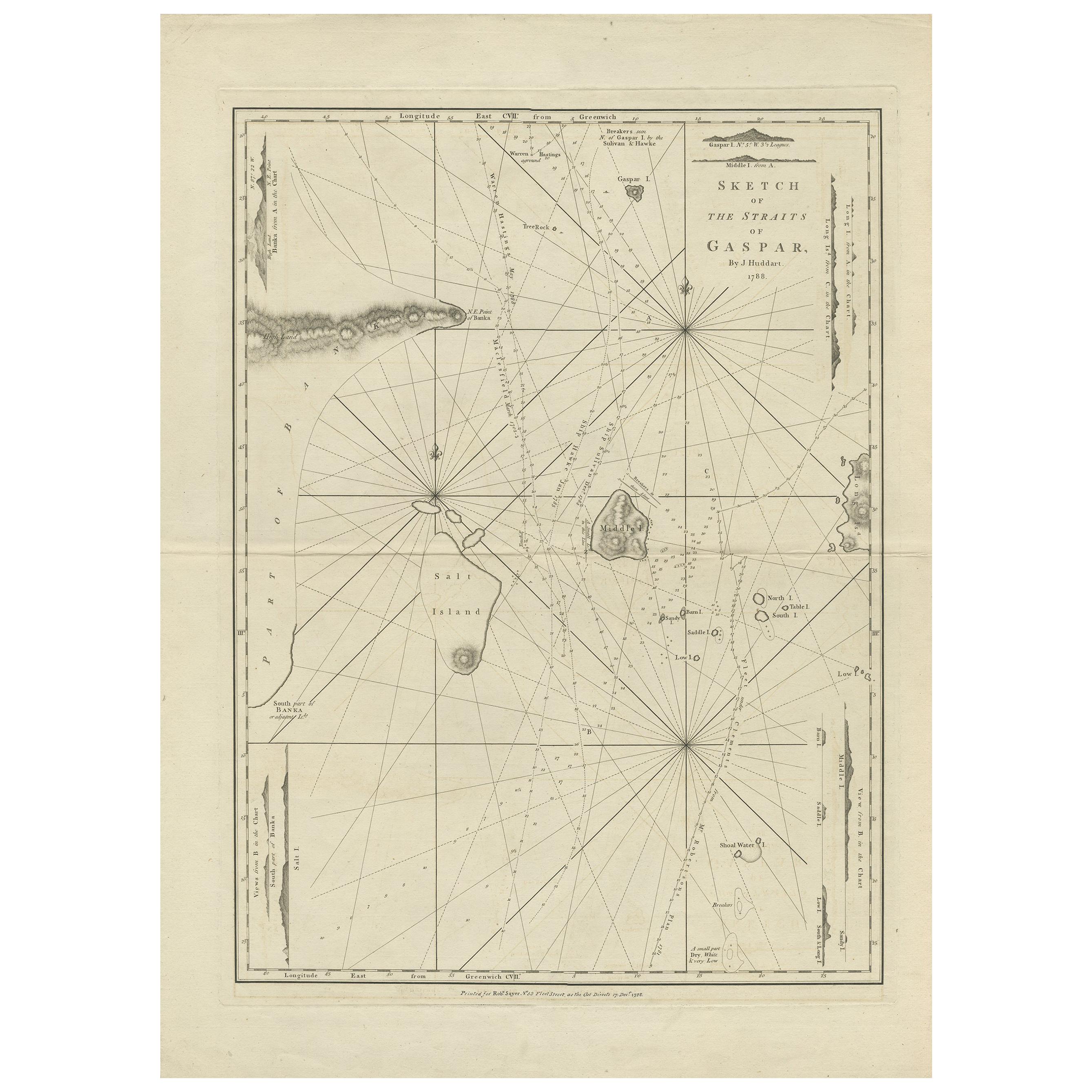
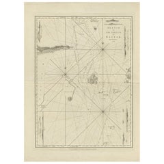
- Antique Map of the Gaspar Strait by Huddart, '1788'Located in Langweer, NLAntique map titled 'Sketch of the Straits of Gaspar'. Detailed sea chart of the Gaspar Strait, showing part of the Island of Banca on the east coast of Sumatra just to the south of S...Category
Antique Late 18th Century Maps
MaterialsPaper
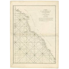
- Antique Coastal Map of West Sumatra 'Indonesia' by J. Mannevillette, 1745Located in Langweer, NLAntique map titled 'Carte de la côte occidentale de l'isle Sumatra depuis la ligne équinoctiale jusqu'au détroit de la Sonde'. Beautiful coastal map of We...Category
Antique Mid-18th Century Maps
MaterialsPaper
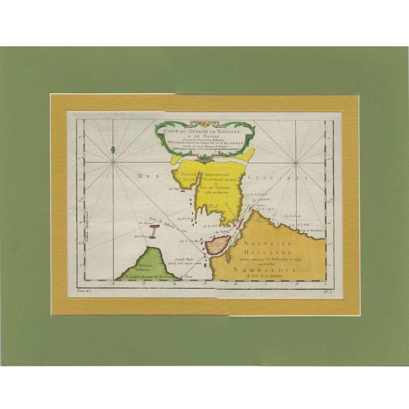
- Antique Map of the Strait Between Nova Zembla and the Mainland of RussiaLocated in Langweer, NLAntique map titled 'Carte du Detroit de Waeigats ou de Nassau'. Detailed regional map of the Strait of Waeigats in the Arctic Sea. Includes a decorative title cartouche. One of the m...Category
Antique Mid-18th Century Maps
MaterialsPaper
- Antique Map of South America by J. Cook, 1775Located in Langweer, NLAntique map titled 'Kaart van het Zuidlyk Eind van Amerika'. Map of the sourthern part of South America, focusing on Cook's tracks around the Cape Horn and T...Category
Antique Mid-18th Century Maps
MaterialsPaper
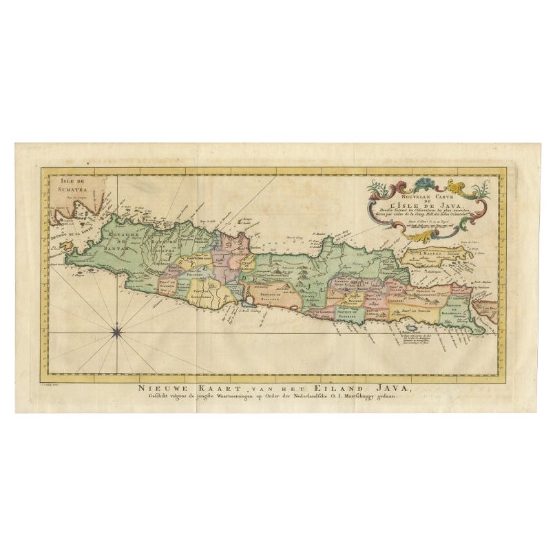
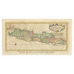
- Antique Map of Java, Madura, Bali and the Sunda Strait, Indonesia, c.1770Located in Langweer, NLAntique map Indonesia titled 'Nouvelle Carte de l'Isle de Java - Nieuwe kaart, van het Eiland Java'. Chart of the island of Java, depicting soun...Category
Antique 18th Century Maps
MaterialsPaper


You May Also Like
- Original Antique Map of The World by Thomas Clerk, 1817Located in St Annes, LancashireGreat map of The Eastern and Western Hemispheres On 2 sheets Copper-plate engraving Drawn and engraved by Thomas Clerk, Edinburgh. Published by Mackenzie And Dent, 1817 ...Category
Antique 1810s English Maps
MaterialsPaper
- Original Antique Map of The Netherlands, Engraved by Barlow, Dated 1807Located in St Annes, LancashireGreat map of Netherlands Copper-plate engraving by Barlow Published by Brightly & Kinnersly, Bungay, Suffolk. Dated 1807 Unframed.Category
Antique Early 1800s English Maps
MaterialsPaper
- Map of the Holy Land "Carte de la Syrie et de l'Egypte" by Pierre M. LapieBy Pierre M. LapieLocated in Alamo, CAAn early 19th century map of ancient Syria and Egypt entitled "Carte de la Syrie et de l'Egypte anciennes/dressée par M. Lapie, Colonel d'Etat Major, et...Category
Antique Early 19th Century French Maps
MaterialsPaper
- Large 17th Century Hand Colored Map of England and the British Isles by de WitBy Frederick de WitLocated in Alamo, CAA large hand colored 17th century map of England and the British Isles by Frederick de Wit entitled "Accuratissima Angliæ Regni et Walliæ Principatus", published in Amsterdam in 1680. It is a highly detailed map of England, Scotland, the Scottish Isles...Category
Antique Late 17th Century Dutch Maps
MaterialsPaper
- Map of the Republic of GenoaLocated in New York, NYFramed antique hand-coloured map of the Republic of Genoa including the duchies of Mantua, Modena, and Parma. Europe, late 18th century. Dimension: 25...Category
Antique Late 18th Century European Maps
- Germany West of the Rhine: A Hand-colored 18th Century Map by de WitBy Frederick de WitLocated in Alamo, CAThis original 18th century hand-colored map of the county of Moers, Germany entitled "Illustrissimo Celsissmo Principi GUILIELMO HENRICO D.G. Arausionum Principi Domino suo Clementis...Category
Antique Early 18th Century Dutch Maps
MaterialsPaper


Recently Viewed
View AllMore Ways To Browse
Antique Maps And Charts
Oriental Antiques Collectables
East Coast Antiques
Borneo Antique
Antique Furniture Detroit
La Sortie
Antique Map Of Detroit
Antique Detroit Map
Antique Maps Buy
Portugal Antiques
Antique Geography
Holland Map
Dutch Map
Antique French Folding
Antique World Atlas
Fold Out Office
Book Maps
Map Set