Items Similar to Antique Map of Juan Fernandez Island and Cumberland Bay, Chile - c. '1749'

Want more images or videos?
Request additional images or videos from the seller
1 of 6
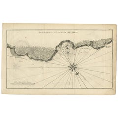
Antique Map of Juan Fernandez Island and Cumberland Bay, Chile - c. '1749'
About the Item
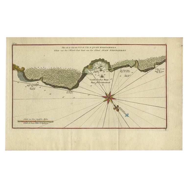
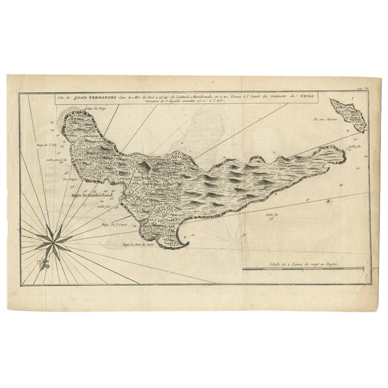
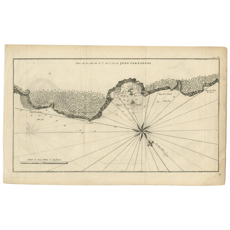
Antique map titled 'Plan de la Côte du N.E. de l 'Ile de Juan Fernandes - Schets van den Noord-Oost kant van het eiland Juan Fernandes '. This map depicts the northeast coast of the island of Juan Fernandez with Cumberland Bay, South America.
In 1740 Anson set sail in command of a squadron sent to attack Spanish possessions and interests in South America. The expedition was ill-equipped and failed to carry out its original ambitious mission. By June 1741 when Anson reached Juan Fernandes, his force had been reduced to only three of the original six ships, while the strength of his crews had fallen from 961 to 335. After launching several attacks on the west coast of South America and recuperating on the island he collected the remaining survivors on his flagship, the Centurion, and set sail in search of one of the richly laden galleons that conducted the trade between Mexico and the Philippines. The indomitable perseverance he had shown during one of the most arduous voyages in the history of sea adventure gained the reward of the capture of an immensely rich prize, the Nuestra Señora de Covadonga, which he encountered off Cape Espiritu Santo on June 20, 1743. This map originates from 'Reize rondsom de Werreld (..)' by George Anson, published 1749.
The Juan Fernández Islands are a sparsely inhabited island group in the South Pacific Ocean reliant on tourism and fishing. Situated 670 km (362 nmi; 416 mi) off the coast of Chile, they are composed of three main volcanic islands: Robinson Crusoe, Alejandro Selkirk and Santa Clara. The group is part of Insular Chile.
The islands are primarily known for having been the home to the marooned sailor Alexander Selkirk for more than four years from 1704, which may have inspired Daniel Defoe's Robinson Crusoe. Most of the archipelago's present-day inhabitants reside on Robinson Crusoe Island, and mainly in the capital, San Juan Bautista, located at Cumberland Bay on the island's north coast.
The group of islands is part of Chile's Valparaíso Region (which also includes Easter Island) and, along with the Desventuradas Islands, forms one of the nine communes of Valparaíso Province. The islands are named after Juan Fernández, the explorer who discovered them in the 1570s.
- Dimensions:Height: 10.63 in (27 cm)Width: 16.74 in (42.5 cm)Depth: 0.02 in (0.5 mm)
- Materials and Techniques:
- Period:
- Date of Manufacture:1749
- Condition:Age-related toning, original folding lines. Shows some wear and staining, blank verso. Please study images carefully.
- Seller Location:Langweer, NL
- Reference Number:
About the Seller
5.0
Platinum Seller
These expertly vetted sellers are 1stDibs' most experienced sellers and are rated highest by our customers.
Established in 2009
1stDibs seller since 2017
1,940 sales on 1stDibs
Typical response time: <1 hour
- ShippingRetrieving quote...Ships From: Langweer, Netherlands
- Return PolicyA return for this item may be initiated within 14 days of delivery.
More From This SellerView All
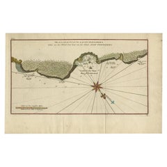
- Antique Map of Juan Fernandez Island, Chile, c.1750Located in Langweer, NLAntique map titled 'Plan de la Côte du N.E. de l 'Ile de Juan Fernandes'. Map of the northeast coast of the island of Juan Fernandez with Cumberland Bay, South America. In 1740 A...Category
Antique 18th Century Maps
MaterialsPaper
- Antique Map of Juan Fernandez Island by Anson '1749'Located in Langweer, NLAntique map titled 'l'Ile de Juan Fernandes dans la Mer du Sud (..) - Het Eiland Juan Fernandes in de Zuid Zee (..)'. This map depicts Juan Fernandez Island in the Southern Sea. This...Category
Antique Mid-18th Century Maps
MaterialsPaper
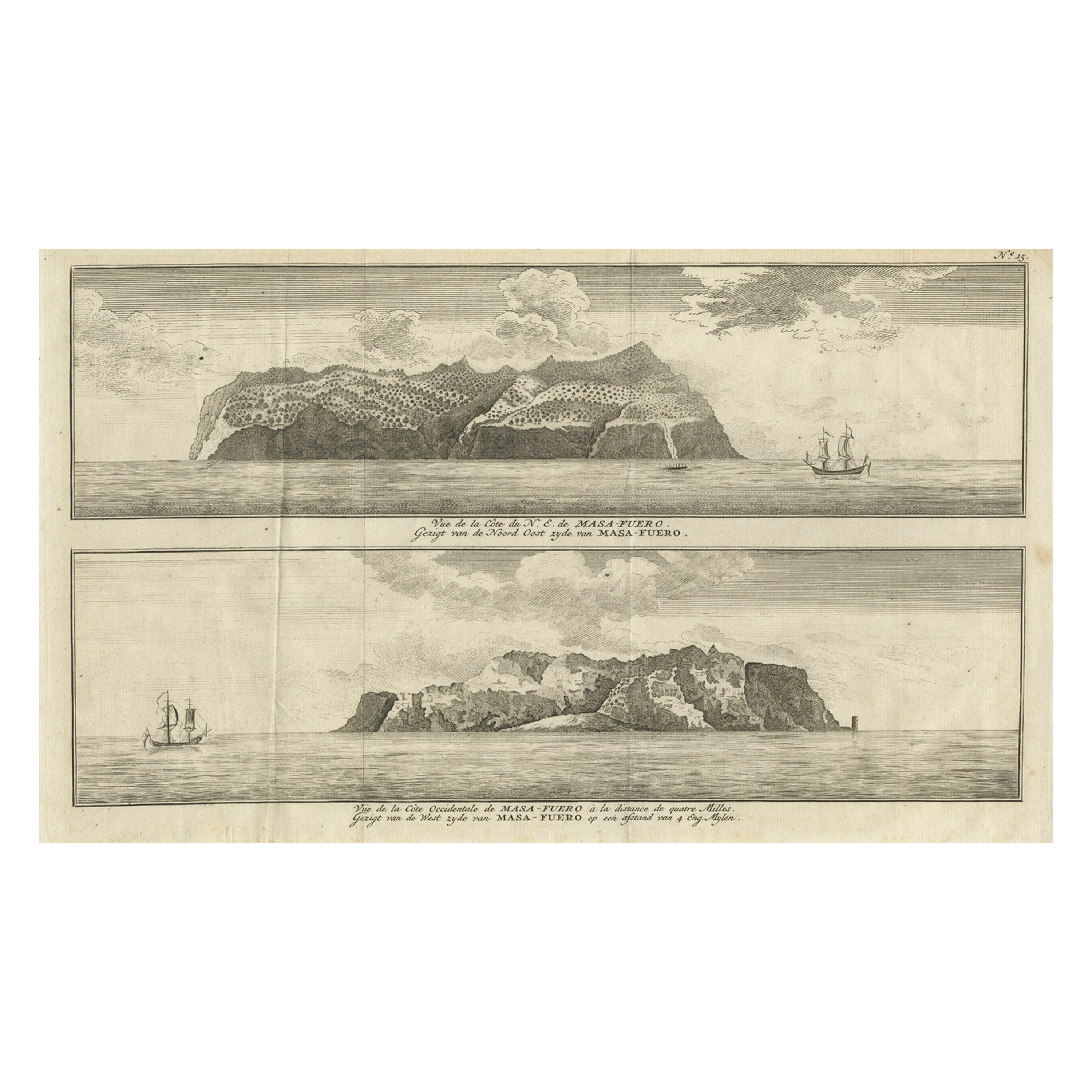
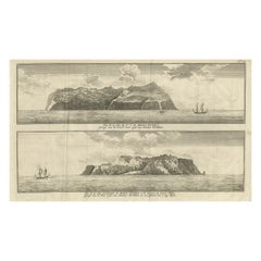
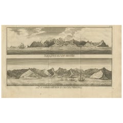
- Engraving of Alejandro Selkirk Island, Juan Fernández-archipel, Chile, 1749Located in Langweer, NLAntique print titled 'Vue de la cote du N. E. de Masa-Fuero' - 'Vue de la cote occidentale de Masa-Fuero a la distance de quatre milles.' Views of Alejandro Selkirk Island...Category
Antique 18th Century Prints
MaterialsPaper
- Antique Map of Juan Fernandez, Chile, c.1740Located in Langweer, NLAntique map titled 'l'Ile de Juan Fernandes dans la Mer du Sud (..)'. This map depicts Juan Fernandez Island in the Southern Sea. Source unknown, to be determined. Artists and En...Category
Antique 18th Century Maps
MaterialsPaper
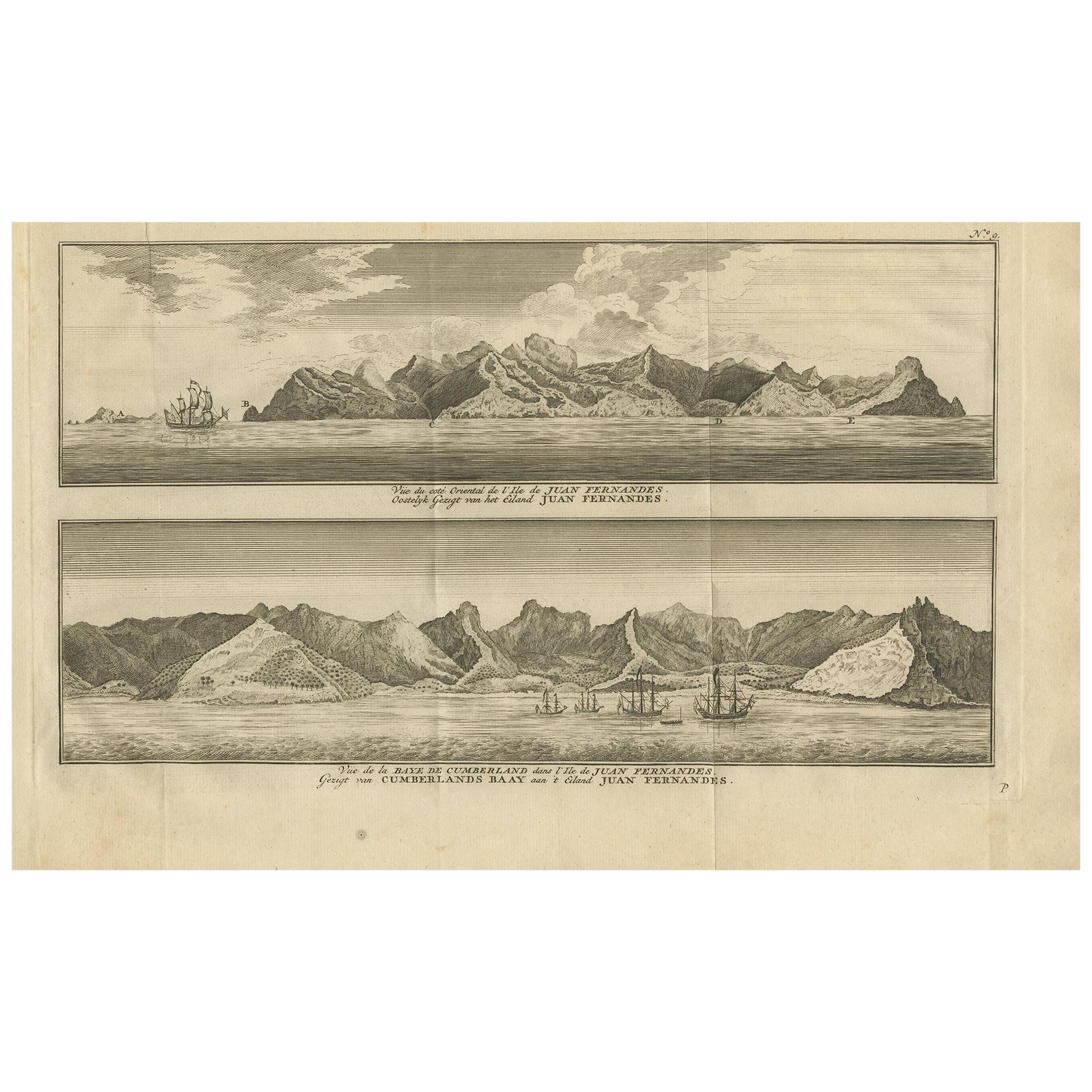
- Antique Print of Cumberland Bay and Juan Fernandez Island by Anson, 1749Located in Langweer, NLAntique print titled 'Vue du cote oriental de l'Ile de Juan Fernandes.' 'Vue de la Baye de Cumberland dans l'Ile de Juan Fernandes.' Eastern view of Juan Fernandez Island; View of th...Category
Antique Mid-18th Century Prints
MaterialsPaper
- Antique Map of Juan Fernandez Island by Anson, c.1740Located in Langweer, NLAntique map titled 'Plan de la Côte du N.E. de l 'Ile de Juan Fernandes'. Map of the northeast coast of the island of Juan Fernandez with Cumberland Bay, South America. In 1740 Ans...Category
Antique 18th Century Maps
MaterialsPaper

You May Also Like
- Antique Map of Principality of MonacoBy Antonio Vallardi EditoreLocated in Alessandria, PiemonteST/619 - "Old Geographical Atlas of Italy - Topographic map of ex-Principality of Monaco" - ediz Vallardi - Milano - A somewhat special edition ---Category
Antique Late 19th Century Italian Other Prints
MaterialsPaper
- Hand-Colored 18th Century Homann Map of Denmark and Islands in the Baltic SeaBy Johann Baptist HomannLocated in Alamo, CAAn 18th century copper plate hand-colored map entitled "Insulae Danicae in Mari Balthico Sitae utpote Zeelandia, Fionia, Langelandia, Lalandia, Falstria, Fembria Mona" created by Joh...Category
Antique Early 18th Century German Maps
MaterialsPaper
- Original Antique Map of Ireland- Tipperary and Waterford. C.1840Located in St Annes, LancashireGreat map of Tipperary and Waterford Steel engraving Drawn under the direction of A.Adlard Published by How and Parsons, C.1840 Unframed.Category
Antique 1840s English Maps
MaterialsPaper
- Original Antique Map of Spain and Portugal, circa 1790Located in St Annes, LancashireSuper map of Spain and Portugal Copper plate engraving by A. Bell Published, circa 1790. Unframed.Category
Antique 1790s English Other Maps
MaterialsPaper
- Original Antique Map of Italy. C.1780Located in St Annes, LancashireGreat map of Italy Copper-plate engraving Published C.1780 Unframed.Category
Antique Early 1800s English Georgian Maps
MaterialsPaper

- Original Antique Map of Asia. C.1780Located in St Annes, LancashireGreat map of Asia Copper-plate engraving Published C.1780 Two small worm holes to right side of map Unframed.Category
Antique Early 1800s English Georgian Maps
MaterialsPaper


