Items Similar to Antique Map of Germany of German in Roman Times, c.1660


Want more images or videos?
Request additional images or videos from the seller
1 of 5
Antique Map of Germany of German in Roman Times, c.1660
$815.44
$1,019.3020% Off
£606.61
£758.2620% Off
€680
€85020% Off
CA$1,116.62
CA$1,395.7720% Off
A$1,241.53
A$1,551.9120% Off
CHF 648.26
CHF 810.3220% Off
MX$15,112.42
MX$18,890.5220% Off
NOK 8,271.48
NOK 10,339.3520% Off
SEK 7,749.98
SEK 9,687.4820% Off
DKK 5,176.46
DKK 6,470.5820% Off
Shipping
Retrieving quote...The 1stDibs Promise:
Authenticity Guarantee,
Money-Back Guarantee,
24-Hour Cancellation
About the Item
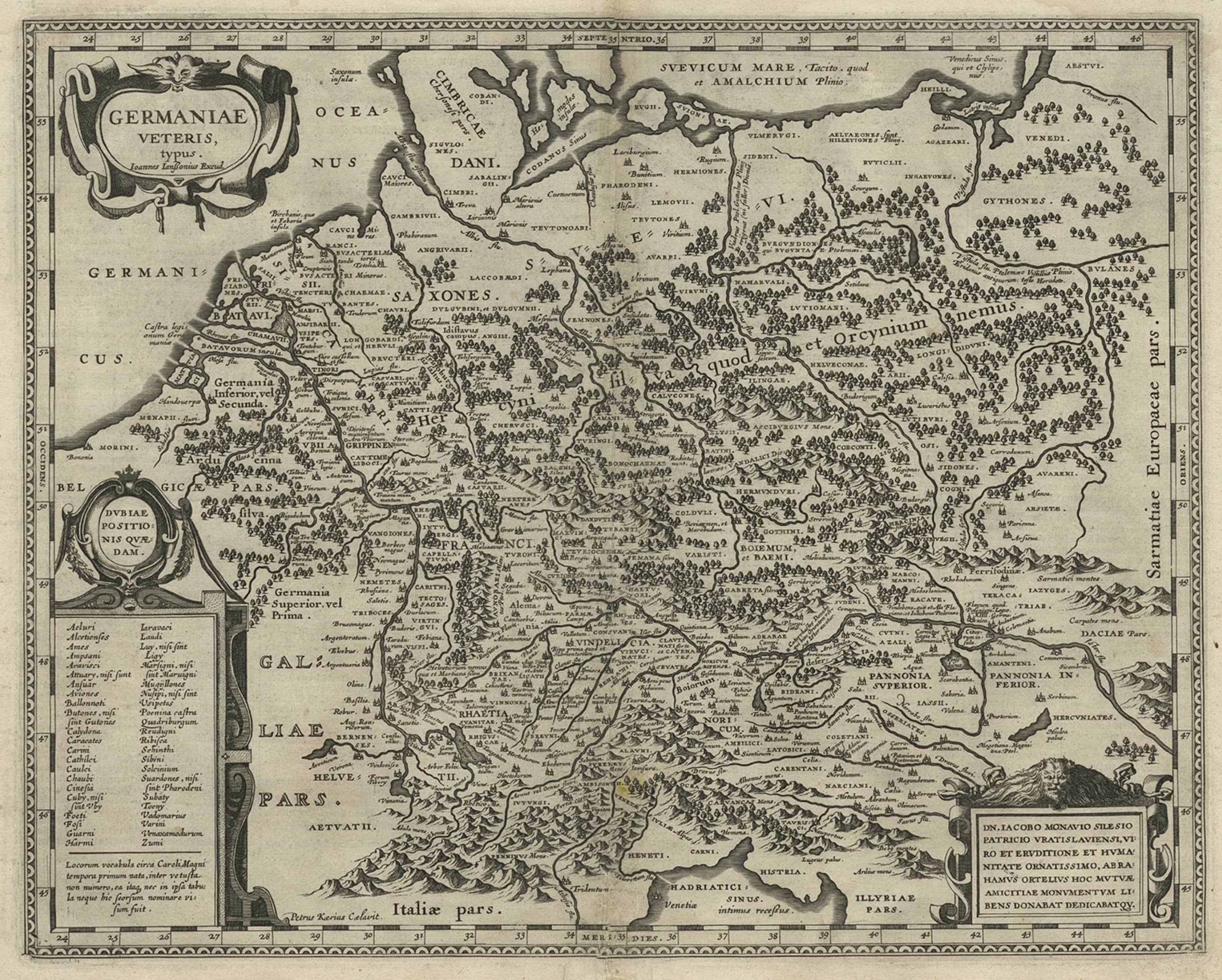
Antique map Germany titled 'Germaniae Veteris Typus'. Antique map probably by Blaeu or based on an earlier state by W. Blaeu.
Minor differences shown in the cartouches. Top left has a human head in the strapwork in this map compared with what looks like a feline (leopard's) head in the Atlas Novus state. Similarly, this map has a human head above the centre of the cartouche in the lower right whereas the Atlas Novus state has a lion's head and main. Source unknown, to be determined. Artists and Engravers: Anonymous.
Artist: Anonymous.
We sell original antique maps to collectors, historians, educators and interior decorators all over the world. Our collection includes a wide range of authentic antique maps from the 16th to the 20th centuries. Buying and collecting antique maps is a tradition that goes back hundreds of years. Antique maps have proved a richly rewarding investment over the past decade, thanks to a growing appreciation of their unique historical appeal. Today the decorative qualities of antique maps are widely recognized by interior designers who appreciate their beauty and design flexibility. Depending on the individual map, presentation, and context, a rare or antique map can be modern, traditional, abstract, figurative, serious or whimsical. We offer a wide range of authentic antique maps for any budget.
- Dimensions:Height: 20.87 in (53 cm)Width: 25.2 in (64 cm)Depth: 0 in (0.01 mm)
- Materials and Techniques:
- Period:
- Date of Manufacture:circa 1660
- Condition:Condition: Good, general age-related toning. A brownish spot in the upper part of the fold line. Mounted, please study image carefully.
- Seller Location:Langweer, NL
- Reference Number:Seller: BG-091661stDibs: LU3054326282552
About the Seller
5.0
Recognized Seller
These prestigious sellers are industry leaders and represent the highest echelon for item quality and design.
Platinum Seller
Premium sellers with a 4.7+ rating and 24-hour response times
Established in 2009
1stDibs seller since 2017
2,510 sales on 1stDibs
Typical response time: <1 hour
- ShippingRetrieving quote...Shipping from: Langweer, Netherlands
- Return Policy
Authenticity Guarantee
In the unlikely event there’s an issue with an item’s authenticity, contact us within 1 year for a full refund. DetailsMoney-Back Guarantee
If your item is not as described, is damaged in transit, or does not arrive, contact us within 7 days for a full refund. Details24-Hour Cancellation
You have a 24-hour grace period in which to reconsider your purchase, with no questions asked.Vetted Professional Sellers
Our world-class sellers must adhere to strict standards for service and quality, maintaining the integrity of our listings.Price-Match Guarantee
If you find that a seller listed the same item for a lower price elsewhere, we’ll match it.Trusted Global Delivery
Our best-in-class carrier network provides specialized shipping options worldwide, including custom delivery.More From This Seller
View AllAntique Map of Southern Germany by F. de Wit, circa 1680
Located in Langweer, NL
This antique map depicts a portion of southern Germany that included the historic regions of Bavaria, the Palatinate, Prussia-Brandenburg, the Rhineland and Saxony. Regensberg, Freis...
Category
Antique Late 17th Century Maps
Materials
Paper

$666 Sale Price
20% Off
Antique Map of Westfalia, Germany by Mercator/Hondius, circa '1620'
Located in Langweer, NL
Antique map titled 'Westfalia cum dioecelsi Bremensi'. Original antique map of Germany. Published by Mercator/Hondius, circa '1620'
17th Century antique detailled map of Westphali...
Category
Antique 16th Century Maps
Materials
Paper
$911 Sale Price
20% Off
Original Rare Antique Map of the Ancient German Empire in Northern Europe, c1650
Located in Langweer, NL
Antique map titled 'Germaniae Veteris typus.'
Map of the ancient German Empire in Northern Europe, based upon an earlier map by Ortelius. Extends fr...
Category
Antique 1650s Maps
Materials
Paper
$633 Sale Price
20% Off
Antique Map of Germany During the Mid-18th Century, Published in 1747
Located in Langweer, NL
Antique map Germany titled 'A New & Accurate Map of Germany'. It covers Germany during the mid-18th century, which included all of modern day Germany, Austria, Switzerland, Czech Rep...
Category
Antique 18th Century Maps
Materials
Paper

$201 Sale Price
20% Off
Antique Map of Germany from a 17th Century Pocket Atlas, 1685
Located in Langweer, NL
Antique map titled 'Nova Totius Germaniae descriptio.' Miniature map of Germany, from the pocket atlas 'Introductionis in Universam Geographiam tam Veterem...
Category
Antique 17th Century Maps
Materials
Paper
$119 Sale Price
20% Off
Antique Map of the Nassau Region in Western Germany
Located in Langweer, NL
Antique map titled 'Nassovia Principatus (..)'. Detailed map of the Nassau region in western Germany between Koblenz, Hadamar, Giessen, Frankfurt and Mainz. The map is filled with in...
Category
Antique Early 18th Century Maps
Materials
Paper

$632 Sale Price
20% Off
You May Also Like
17th Century Hand-Colored Map of a Region in West Germany by Janssonius
By Johannes Janssonius
Located in Alamo, CA
This attractive highly detailed 17th century original hand-colored map is entitled "Archiepiscopatus Maghdeburgensis et Anhaltinus Ducatus cum terris adjacentibus". It was published ...
Category
Antique Mid-17th Century Dutch Maps
Materials
Paper

1657 Janssonius Map of Vermandois and Cappelle, Ric. A-004
Located in Norton, MA
1657 Janssonius map of
Vermandois and Cappelle
Ric.a004
Description: Antique map of France titled 'Descriptio Veromanduorum - Gouvernement de la Cappelle'. Two detailed maps o...
Category
Antique 17th Century Unknown Maps
Materials
Paper

Prussia, Poland, N. Germany, Etc: A Hand-colored 17th Century Map by Janssonius
By Johannes Janssonius
Located in Alamo, CA
This is an attractive hand-colored copperplate engraved 17th century map of Prussia entitled "Prussia Accurate Descripta a Gasparo Henneberg Erlichensi", published in Amsterdam by Joannes Janssonius in 1664. This very detailed map from the golden age of Dutch cartography includes present-day Poland, Latvia, Lithuania, Estonia and portions of Germany. This highly detailed map is embellished by three ornate pink, red, mint green and gold...
Category
Antique Mid-17th Century Dutch Maps
Materials
Paper

1633 Map Entitled "Beauvaisis Comitatus Belova Cium, Ric.0002
Located in Norton, MA
1633 map entitled
"Beauvaisis Comitatus Belova Cium,"
Hand Colored
Ric.0002
Description: Cartographer : - Hondius, Henricus 1587-1638
Artists and Engravers:Jodocus Hondius, one of the most notable engravers of his time. He is known for his work in association with many of the cartographers and publishers prominent at the end of the sixteenth and the beginning of the seventeenth century. A native of Flanders, he grew up in Ghent, apprenticed as an instrument and globe maker and map engraver. In 1584, to escape the religious troubles sweeping the Low Countries at that time, he fled to London where he spent some years before finally settling in Amsterdam about 1593. In the London period he came into contact with the leading scientists and geographers of the day and engraved maps in The Mariner\\\\\\\\\\\\\\\'s Mirrour, the English edition of Waghenaer\\\\\\\\\\\\\\\'s Sea Atlas, as well as others with Pieter van den Keere, his brother-in-law. No doubt his temporary exile in London stood him in good stead, earning him an international reputation, for it could have been no accident that Speed chose Hondius to engrave the plates for the maps in The Theatre of the Empire of Great Britaine in the years between 1605 and 1610. In 1604 Hondius bought the plates of Mercator\\\\\\\\\\\\\\\'s Atlas which, in spite of its excellence, had not competed successfully with the continuing demand for the Ortelius Theatrum Orbis Terrarum. To meet this competition Hondius added about 40 maps to Mercator\\\\\\\\\\\\\\\'s original number and from 1606 published enlarged editions in many languages, still under Mercator\\\\\\\\\\\\\\\'s name but with his own name as publisher. These atlases have become known as the Mercator/Hondius series. The following year the maps were reengraved in miniature form and issued as a pocket Atlas Minor. After the death of Jodocus Hondius the Elder in 1612, work on the two atlases, folio and miniature, was carried on by his widow and sons, Jodocus II and Henricus, and eventually in conjunction with Jan Jansson in Amsterdam.
In all, from 1606 onwards, nearly 50 editions with increasing numbers of maps with texts in the main European languages were printed. Summaries of these issues are given under the entry for Gerard Mercator. Jodocus Hondius the Elder * 1588 Maps in The Mariner\\\\\\\\\\\\\\\'s Mirrour (Waghenaer/Ashley) * 1590 World Map...
Category
Antique 17th Century Dutch Maps
Materials
Paper

1640 Joan Bleau Map Entitled"Diocecese de rheims et le pais de rethel, " Eic.a011
Located in Norton, MA
1640 Joan Bleau map entitled
"Diocecese de rheims et le pais de rethel,"
Ric.a011
OAN BLAEU
Diocecese de Rheims, et le pais de Rethel.
Handcolored engraving, c.1640.
...
Category
Antique 17th Century Dutch Maps
Materials
Paper

1633 Map "La Souverainete De Sedan Et De Raucourt, Et La Prevoste Ric0011
Located in Norton, MA
1653 map entitled
"La Souverainete de Sedan et de Raucourt, et la Prevoste de Doncheri,"
Ric0011
Description:
Lovely map centered on Sedan and Doncheri and the Meuze River fr...
Category
Antique 17th Century Dutch Maps
Materials
Paper

More Ways To Browse
Relief Map
Antique Map Of Venice
Antique Map Of Georgia
Antique Nautical Charts
Hand Painted Antique Map
Antique Maps New Zealand
Antique Maps Persia
Map Railroad
Mariner Furniture
Vintage Glass Map
Antique Furniture Cyprus
Antique Linen Map
Caribbean Colonial Furniture
Antique Maps West Indies
California Island Map
Pirate Antique
Map Of Holy Land
Antique Blackwood Furniture