Items Similar to Antique Map of Meuse ‘France’ by V. Levasseur, 1854

Want more images or videos?
Request additional images or videos from the seller
1 of 5
Antique Map of Meuse ‘France’ by V. Levasseur, 1854
$172.94
$216.1820% Off
£127.37
£159.2120% Off
€144
€18020% Off
CA$235.27
CA$294.0920% Off
A$261.44
A$326.8020% Off
CHF 137
CHF 171.2520% Off
MX$3,206.11
MX$4,007.6420% Off
NOK 1,747.33
NOK 2,184.1620% Off
SEK 1,643.82
SEK 2,054.7820% Off
DKK 1,096.25
DKK 1,370.3120% Off
Shipping
Retrieving quote...The 1stDibs Promise:
Authenticity Guarantee,
Money-Back Guarantee,
24-Hour Cancellation
About the Item
Antique map titled 'Dépt. de la Meuse'. Map of the French department of Meuse, France. This area part of the Lorraine or Alsace-Lorraine wine regions. It is also known for its production of Brie de Meaux cheeses. In fact, more than 60% of Brie de Meaux production takes place in this region. This map originates from ‘Atlas National de la France Illustré’. Published by A. Combette, Paris, 1854.
- Dimensions:Height: 13.98 in (35.5 cm)Width: 20.67 in (52.5 cm)Depth: 0.02 in (0.5 mm)
- Materials and Techniques:
- Period:
- Date of Manufacture:1854
- Condition:General age-related toning. Please study image carefully.
- Seller Location:Langweer, NL
- Reference Number:Seller: BG-05614/851stDibs: LU3054310765021
About the Seller
5.0
Recognized Seller
These prestigious sellers are industry leaders and represent the highest echelon for item quality and design.
Platinum Seller
Premium sellers with a 4.7+ rating and 24-hour response times
Established in 2009
1stDibs seller since 2017
2,494 sales on 1stDibs
Typical response time: 1 hour
- ShippingRetrieving quote...Shipping from: Langweer, Netherlands
- Return Policy
Authenticity Guarantee
In the unlikely event there’s an issue with an item’s authenticity, contact us within 1 year for a full refund. DetailsMoney-Back Guarantee
If your item is not as described, is damaged in transit, or does not arrive, contact us within 7 days for a full refund. Details24-Hour Cancellation
You have a 24-hour grace period in which to reconsider your purchase, with no questions asked.Vetted Professional Sellers
Our world-class sellers must adhere to strict standards for service and quality, maintaining the integrity of our listings.Price-Match Guarantee
If you find that a seller listed the same item for a lower price elsewhere, we’ll match it.Trusted Global Delivery
Our best-in-class carrier network provides specialized shipping options worldwide, including custom delivery.More From This Seller
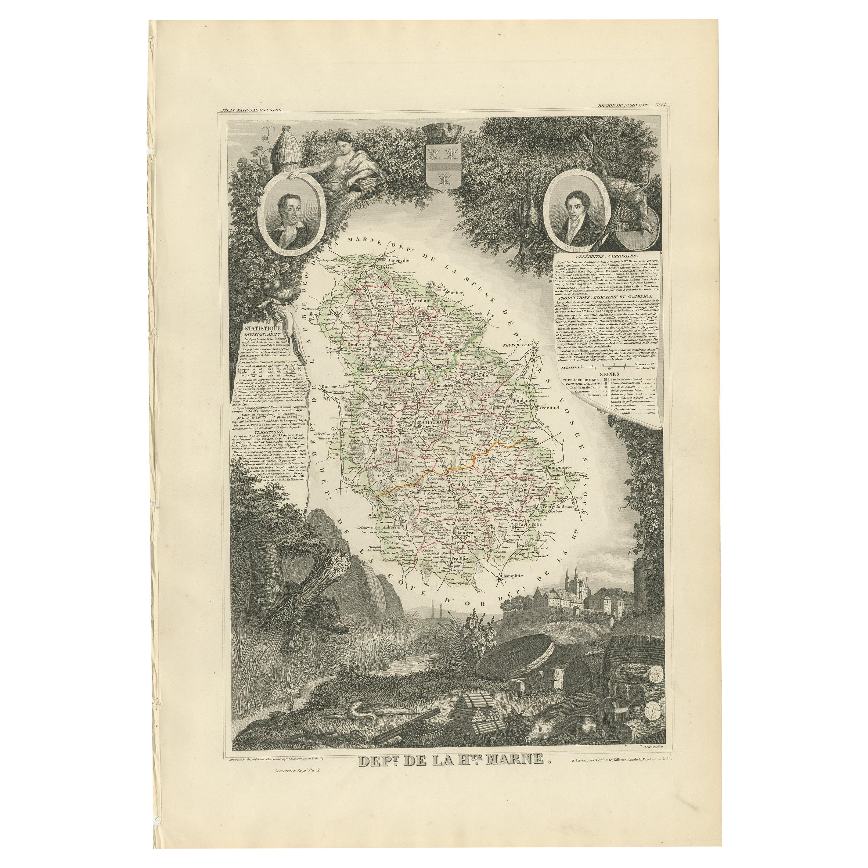
View AllAntique Map of Haute Marne ‘France’ by V. Levasseur, 1854
Located in Langweer, NL
Antique map titled 'Dépt. de la Hte. Marne'. Map of the French department of Haute Marne, France. This department is part of the Champagne region, where the world-famous sparkling wi...
Category
Antique Mid-19th Century Maps
Materials
Paper
$172 Sale Price
20% Off
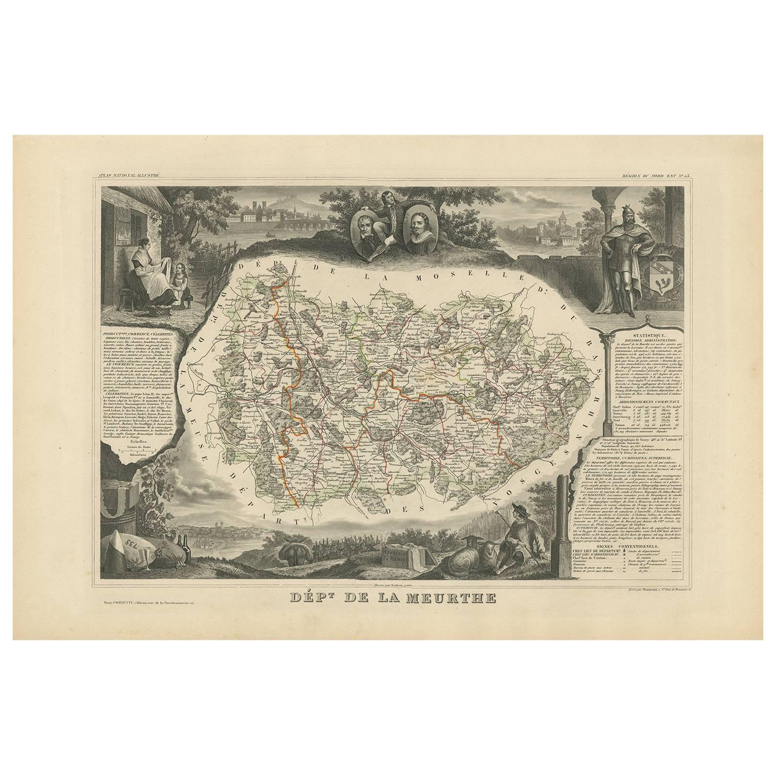
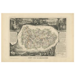
Antique Map of Meurthe ‘France’ by V. Levasseur, 1854
Located in Langweer, NL
Antique map titled 'Dépt. de la Meurthe'. Map of the French department of Meurthe, France. Part of Lorraine and the Alsace-Lorraine wine region. This map originates from ‘Atlas Natio...
Category
Antique Mid-19th Century Maps
Materials
Paper
$172 Sale Price
20% Off
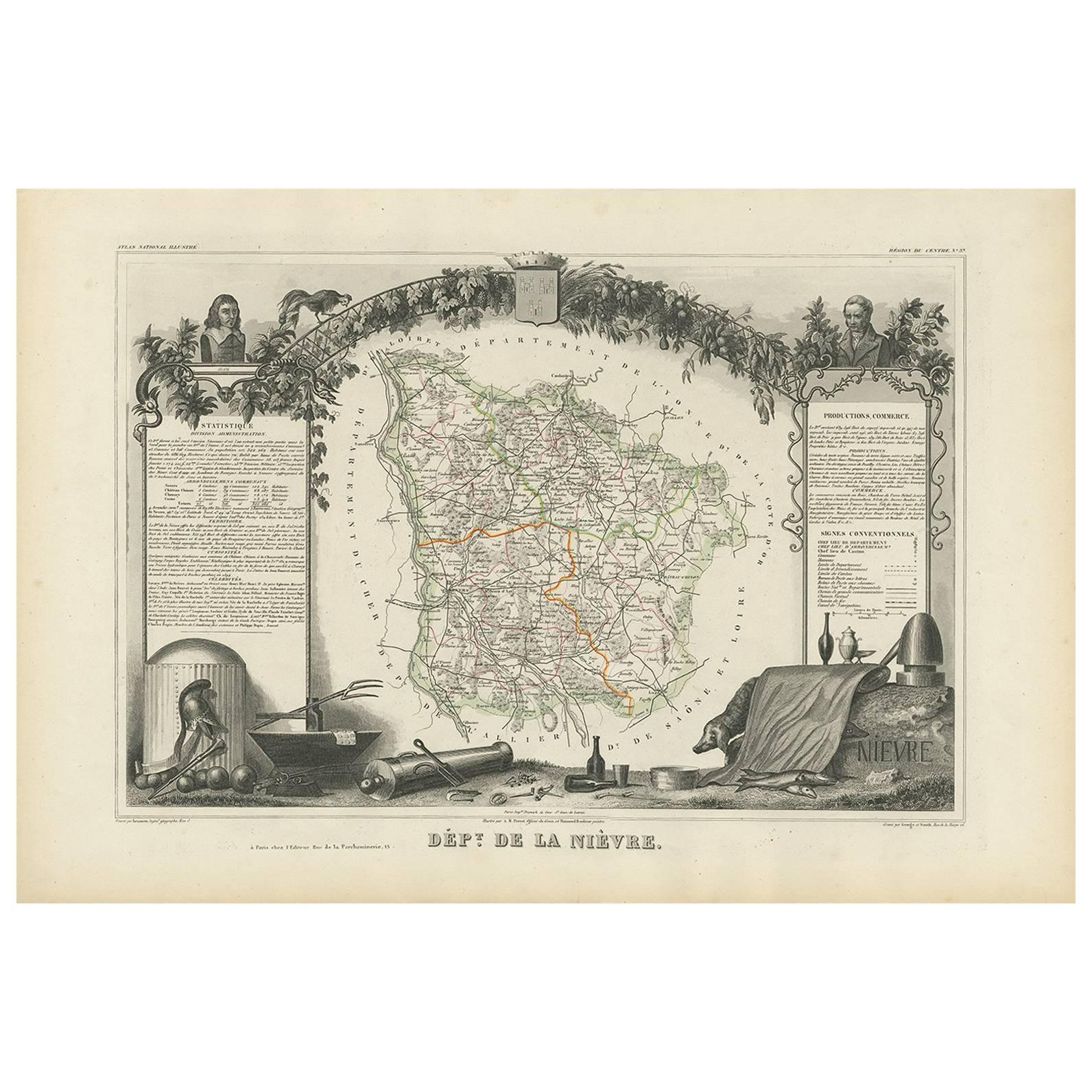
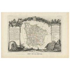
Antique Map of Nièvre ‘France’ by V. Levasseur, 1854
Located in Langweer, NL
Antique map titled 'Dépt. de la Nièvre'. Map of the French department of Nievre, France. Part of the prestiegous Burgundy or Bourgogne wine region this area is known for its producti...
Category
Antique Mid-19th Century Maps
Materials
Paper
$172 Sale Price
20% Off
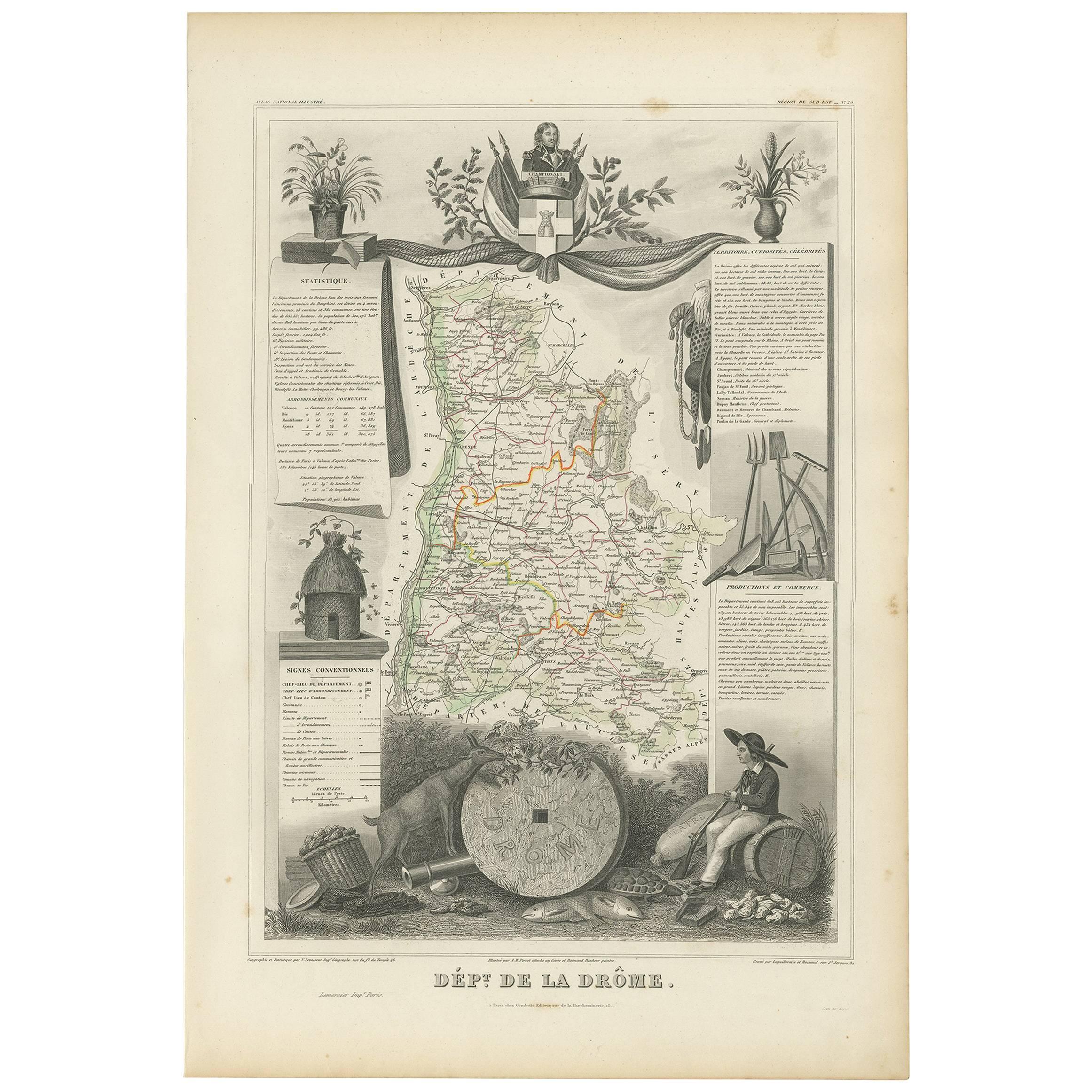
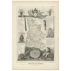
Antique Map of Drôme ‘France’ by V. Levasseur, 1854
Located in Langweer, NL
Antique map titled 'Dépt. de la Drôme'. Map of the French department of Drome, France. This area is known for its production of Picodon, a spicy goats-milk ch...
Category
Antique Mid-19th Century Maps
Materials
Paper
$172 Sale Price
20% Off
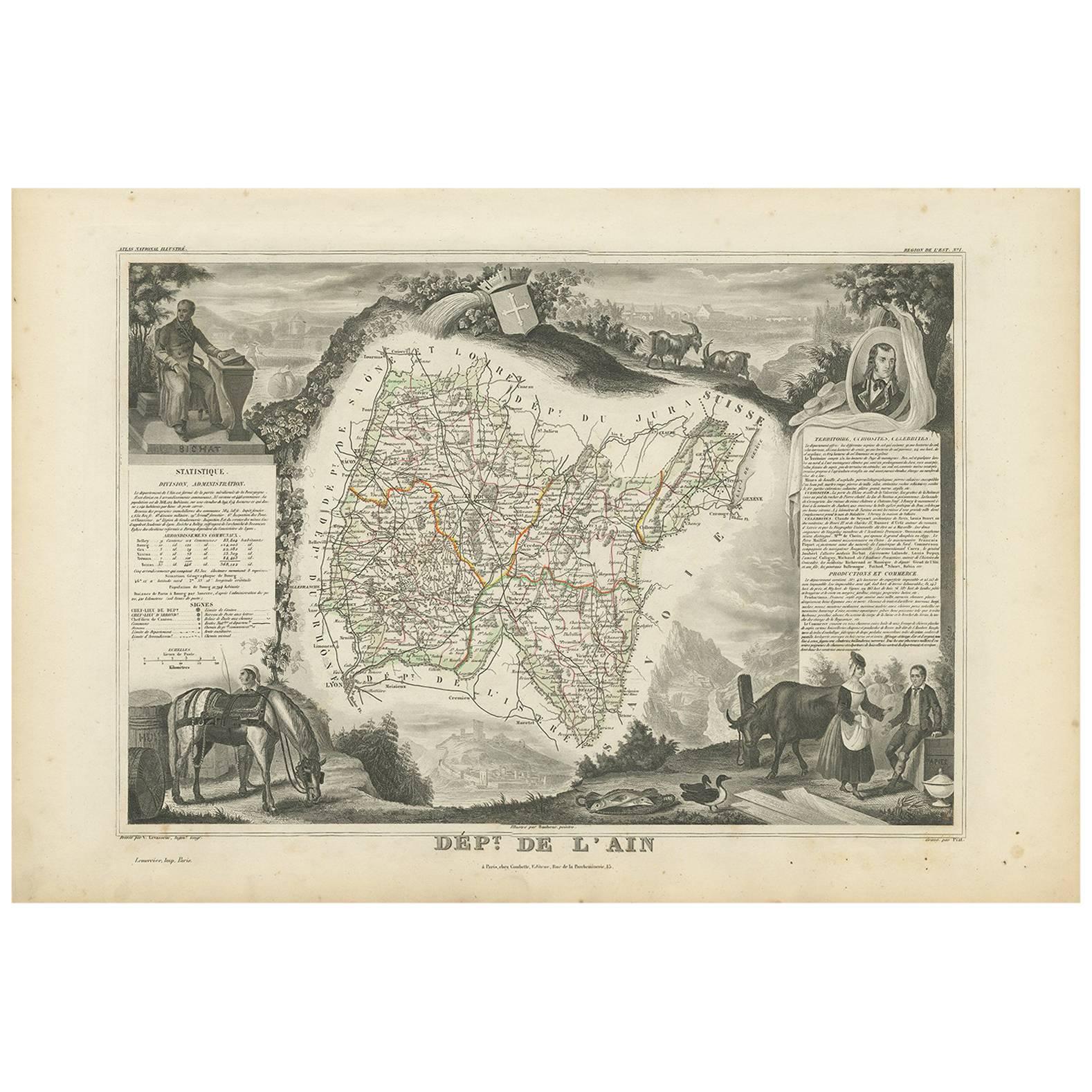
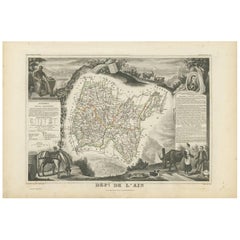
Antique Map of Ain ‘France’ by V. Levasseur, 1854
By Victor Levasseur
Located in Langweer, NL
Antique map titled 'Dépt. de l'Ain'. Map of the French department of l'Ain, France. This area of France is known for its Bugey wines, which are generally aromatic and white. It is al...
Category
Antique Mid-19th Century Maps
Materials
Paper
$172 Sale Price
20% Off
Antique Map of Jura ‘France’ by V. Levasseur, 1854
By Victor Levasseur
Located in Langweer, NL
Antique map titled 'Dépt. du Jura'. Map of the French department Jura, France. The Jura wines are very distinctive and unusual, such as Vin Jaune, which is made by a similar process ...
Category
Antique Mid-19th Century Maps
Materials
Paper

$172 Sale Price
20% Off
You May Also Like
Var, France. Antique map of a French department, 1856
By Victor Levasseur
Located in Melbourne, Victoria
'Dept. du Var', steel engraving with original outline hand-colouring., 1856, from Levasseur's Atlas National Illustre.
Var covers the heart of the French Riviera or Cote d'Azur., and includes the resort cities of Cannes, Nice and San Tropez...
Category
19th Century Naturalistic Landscape Prints
Materials
Engraving

Haut Rhin, France. Antique map of a French department, 1856
By Victor Levasseur
Located in Melbourne, Victoria
'Dept. du Bas Rhin', steel engraving with original outline hand-colouring., 1856, from Levasseur's Atlas National Illustre.
This mountainous area is part of the Alsace wine region ...
Category
19th Century Naturalistic Landscape Prints
Materials
Engraving
Lozere, France. Antique map of a French department, 1856
By Victor Levasseur
Located in Melbourne, Victoria
'Dept. de La Lozere', steel engraving with original outline hand-colouring., 1856, from Levasseur's 'Atlas National Illustre'.
This remote mountainous part of Languedoc is rural, s...
Category
19th Century Naturalistic Landscape Prints
Materials
Engraving

Jura, France. Antique map of a French department, 1856
By Victor Levasseur
Located in Melbourne, Victoria
'Dept. du Jura', steel engraving with original outline hand-colouring., 1856, from Levasseur's 'Atlas National Illustre'.
The Jura wines are very distinctive and unusual, such as V...
Category
19th Century Naturalistic Landscape Prints
Materials
Engraving

Aude, France. Antique map of a French department, 1856
By Victor Levasseur
Located in Melbourne, Victoria
'Dept. de L' Aude', steel engraving with original outline hand-colouring., 1856, from Levasseur's 'Atlas National Illustre'.
This area of France is famous for its wide variety of v...
Category
19th Century Naturalistic Landscape Prints
Materials
Engraving

L'Isere, France. Antique map of French department, 1856
By Victor Levasseur
Located in Melbourne, Victoria
'Dept. de L'Isere', Steel engraving with original outline hand-colouring., 1856, from Levasseur's 'Atlas National Illustre'.
This area is known for its production of Bleu du Vercor...
Category
19th Century Naturalistic Landscape Prints
Materials
Engraving

More Ways To Browse
Wine Map
French Wine Map
Antique Wine Maps
Map Of Africa
London Antique Maps
Antique World Globes
Antique Map Of England
Antique Map Paris
Gold Maps
East India Company
China Map
17th Century World Map
Antique Maps Of Britain
Antique Furniture Edinburgh
Antique English Maps
Map Of India
British Empire Furniture
American West Antiques