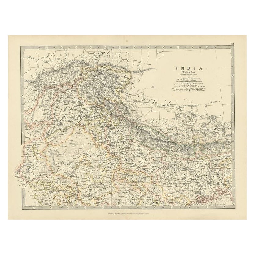
Items Similar to Antique Map of the North-West Frontier by Stanford, 1895
Want more images or videos?
Request additional images or videos from the seller
1 of 5
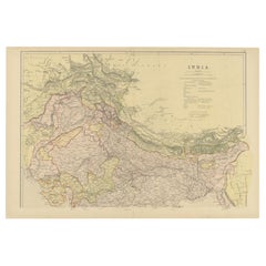
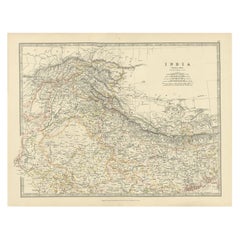
Antique Map of the North-West Frontier by Stanford, 1895
$862.66
$1,078.3320% Off
£642.08
£802.6020% Off
€720
€90020% Off
CA$1,181.63
CA$1,477.0420% Off
A$1,314.23
A$1,642.7920% Off
CHF 686.25
CHF 857.8220% Off
MX$15,992.83
MX$19,991.0420% Off
NOK 8,764.49
NOK 10,955.6120% Off
SEK 8,219.54
SEK 10,274.4320% Off
DKK 5,481.11
DKK 6,851.3920% Off
Shipping
Retrieving quote...The 1stDibs Promise:
Authenticity Guarantee,
Money-Back Guarantee,
24-Hour Cancellation
About the Item
Antique map titled 'Stanford's Sketch Map of the North West Frontier of India from Peshawar to the Pamirs'. Linen backed folding map of the North-West Frontier of India from Peshawar to the Pamirs. Published by Edward Stanford.
- Creator:E. Stanford (Artist)
- Dimensions:Height: 23.63 in (60 cm)Width: 27.56 in (70 cm)Depth: 0.02 in (0.5 mm)
- Materials and Techniques:
- Period:
- Date of Manufacture:1895
- Condition:General age-related toning. Minor wear, please study images carefully.
- Seller Location:Langweer, NL
- Reference Number:Seller: BG-123431stDibs: LU3054319365752
About the Seller
5.0
Recognized Seller
These prestigious sellers are industry leaders and represent the highest echelon for item quality and design.
Platinum Seller
Premium sellers with a 4.7+ rating and 24-hour response times
Established in 2009
1stDibs seller since 2017
2,502 sales on 1stDibs
Typical response time: <1 hour
- ShippingRetrieving quote...Shipping from: Langweer, Netherlands
- Return Policy
Authenticity Guarantee
In the unlikely event there’s an issue with an item’s authenticity, contact us within 1 year for a full refund. DetailsMoney-Back Guarantee
If your item is not as described, is damaged in transit, or does not arrive, contact us within 7 days for a full refund. Details24-Hour Cancellation
You have a 24-hour grace period in which to reconsider your purchase, with no questions asked.Vetted Professional Sellers
Our world-class sellers must adhere to strict standards for service and quality, maintaining the integrity of our listings.Price-Match Guarantee
If you find that a seller listed the same item for a lower price elsewhere, we’ll match it.Trusted Global Delivery
Our best-in-class carrier network provides specialized shipping options worldwide, including custom delivery.More From This Seller
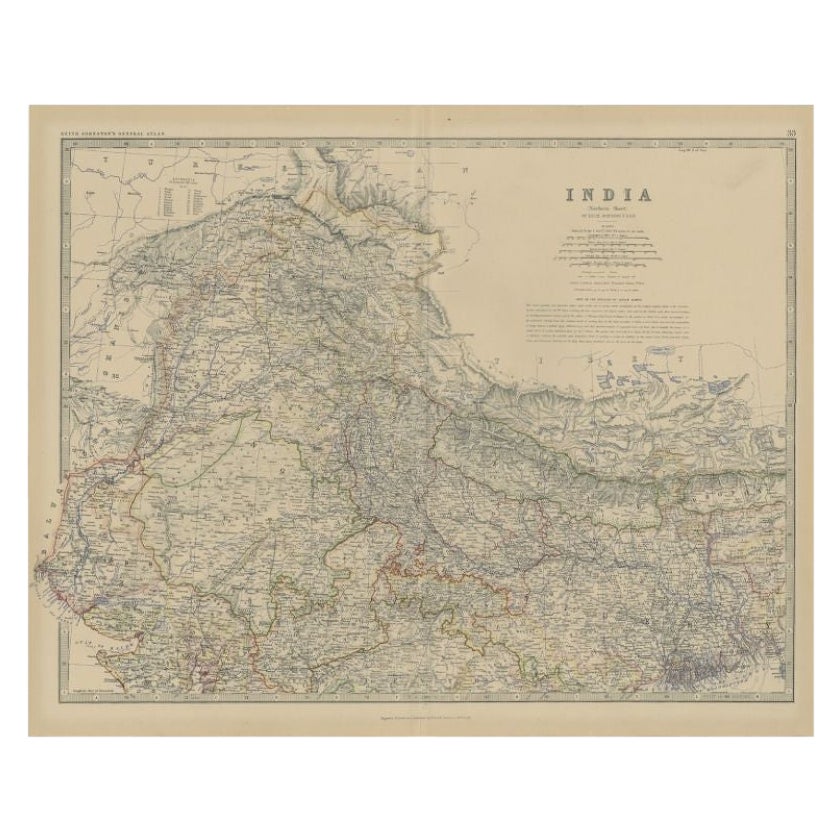
View AllAntique Map of Northern India by Johnston, 1882
Located in Langweer, NL
Antique map titled 'India (Northern Sheet)'. Old map of Northern India. This map originates from 'The Royal Atlas of Modern Geography, Exhibiting, in a Series of Entirely Original an...
Category
Antique 19th Century Maps
Materials
Paper
$129 Sale Price
20% Off
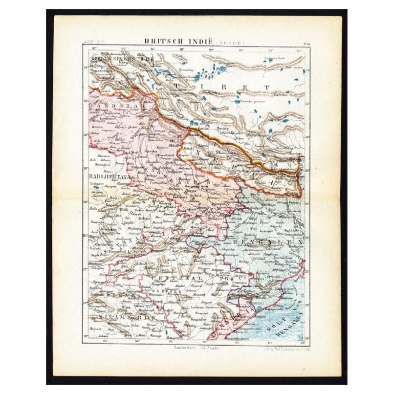
Antique Map of Northern India 'British Indies', C.1880
Located in Langweer, NL
Plate 56 : 'Britsch-Indie, Noord.' (British Indies, North). This lithographed map originates from: 'Wereld-atlas voor Kantoor en Huiskamer' (transl: World Atlas for the office and li...
Category
Antique 19th Century Maps
Materials
Paper
$62 Sale Price
20% Off
Antique Map of Northern India by Blackie & Son, 1860
Located in Langweer, NL
Antique map titled 'India'. Old map depicting northern India. This map originates from 'The Comprehensive Atlas & Geography of the World, Compiled and Engraved from the most Authenti...
Category
Antique 19th Century Maps
Materials
Paper
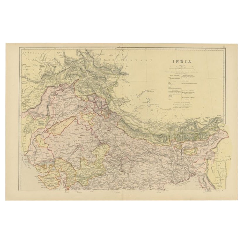
Antique Map of Northern India by Johnston, 1867
Located in Langweer, NL
Antique map titled 'India (Northern Sheet)'. Depicting Rajputana, Bombay, Nepal and more. Originates from the 'Handy Royal Atlas of Modern Geography' by Alex Keith Johnston. Artists ...
Category
Antique 19th Century Maps
Materials
Paper
$112 Sale Price
20% Off
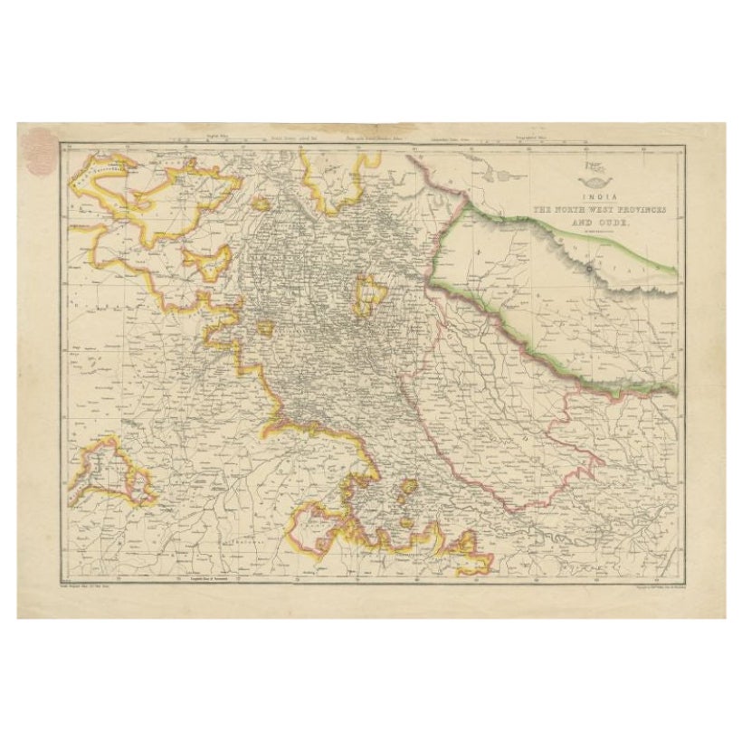
Antique Map of Northwestern India by Weller, 1857
Located in Langweer, NL
Antique map titled 'India, The North West Provinces and Oude'.Detailed map of the northwestern part of India, extending to the Himalaya Mountains. Shows part of Nepal including Dharm...
Category
Antique 19th Century Maps
Materials
Paper
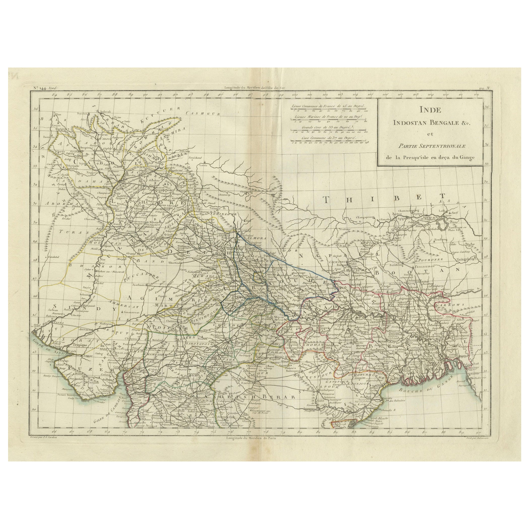
Antique Map of Northern India, Bengal, and Surrounding Regions by Tardieu, 1802
Located in Langweer, NL
This is an original antique map titled "Inde, Indostan Bengale &c. et Partie Septentrionale de la Presqu'isle en deça du Gange," depicting the northern part of the Indian subcontinen...
Category
Antique Early 1800s Maps
Materials
Paper
$421 Sale Price
20% Off
You May Also Like
Original Antique Map of the American State of Idaho & Wyoming, 1903
Located in St Annes, Lancashire
Antique map of Idaho and Wyoming
Published By A & C Black. 1903
Original colour
Good condition
Unframed.
Free shipping
Category
Antique Early 1900s English Maps
Materials
Paper

Original Antique Map of the American State of Colorado, 1903
Located in St Annes, Lancashire
Antique map of Colorado
Published By A & C Black. 1903
Original colour
Good condition
Unframed.
Free shipping
Category
Antique Early 1900s English Maps
Materials
Paper

Original Antique Decorative Map of South America-West Coast, Fullarton, C.1870
Located in St Annes, Lancashire
Great map of Chili, Peru and part of Bolivia
Wonderful figural border
From the celebrated Royal Illustrated Atlas
Lithograph. Original color.
Published by Fullarton, Edi...
Category
Antique 1870s Scottish Maps
Materials
Paper

Large Original Antique Map of Utah, USA, 1894
By Rand McNally & Co.
Located in St Annes, Lancashire
Fabulous map of Utah
Original color
By Rand, McNally & Co.
Published, 1894
Unframed
Free shipping.
Category
Antique 1890s American Maps
Materials
Paper

South America, North-West Part. Century Atlas antique vintage map
Located in Melbourne, Victoria
'The Century Atlas. South America, North-West Part'
Original antique map, 1903.
Central fold as issued. Map name and number printed on the reverse corners.
Sheet 40cm by 29.5cm.
Category
Early 20th Century Victorian More Prints
Materials
Lithograph

Original Antique Map of India by Dower, circa 1835
Located in St Annes, Lancashire
Nice map of India
Drawn and engraved by J.Dower
Published by Orr & Smith. C.1835
Unframed.
Free shipping
Category
Antique 1830s English Maps
Materials
Paper

More Ways To Browse
Stanford Furniture
Antique Linen Map
Stanford Antique Furniture
Indonesia Map
Antique Framed Map Engravings
Atlas Furniture Company
Used Office Furniture Edinburgh
Antique 16th Century Plates
Scotland Map
Antique Maps Indonesia
Map Of Japan
Antique Rollers
Compass Rose Antique
Dutch Empire
Swiss Antiques And Collectables
Antique Compass Map
Blaeu Maps
Coat Of Arms German