Items Similar to Antique Map of Quinam and the Côn ?ao Islands by Sayer, 1778


Want more images or videos?
Request additional images or videos from the seller
1 of 5
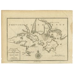
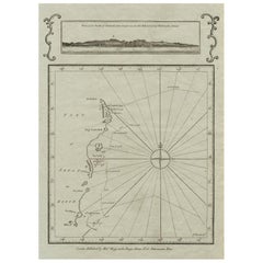
Antique Map of Quinam and the Côn ?ao Islands by Sayer, 1778
$316.31
$395.3920% Off
£235.43
£294.2920% Off
€264
€33020% Off
CA$433.27
CA$541.5820% Off
A$481.89
A$602.3620% Off
CHF 251.63
CHF 314.5320% Off
MX$5,864.04
MX$7,330.0520% Off
NOK 3,213.65
NOK 4,017.0620% Off
SEK 3,013.83
SEK 3,767.2920% Off
DKK 2,009.74
DKK 2,512.1720% Off
Shipping
Retrieving quote...The 1stDibs Promise:
Authenticity Guarantee,
Money-Back Guarantee,
24-Hour Cancellation
About the Item
Antique map titled 'A Chart of a part of the Coast of Cochinchina' and 'Plan of Pulo Condor'. Two maps on one sheet. The upper map shows part of the coast of Cochinchina from Cham Collao Island to the King's River. Cochinchina or Quinam is a region encompassing the southern third of current Vietnam whose principal city is Saigon. The lower map shows the Côn Ð?o Islands, an archipelago of Bà R?a–Vung Tàu Province, in the Southeast region of Vietnam, and a district of this province.
Artist: Printed for R. Sayer & J. Bennett.
Condition: Good, age-related toning. Small repair right margin. Please study image carefully.
Date: 1778
Overall size: 38 x 54 cm.
Image size: 0.001 x 32.5 x 47 cm.
Antique prints have long been appreciated for both their aesthetic and investment value. They were the product of engraved, etched or lithographed plates. These plates were handmade out of wood or metal, which required an incredible level of skill, patience and craftsmanship. Whether you have a house with Victorian furniture or more contemporary decor an old engraving can enhance your living space. We offer a wide range of authentic antique prints for any budget.
- Dimensions:Height: 21.26 in (54 cm)Width: 14.97 in (38 cm)Depth: 0 in (0.01 mm)
- Materials and Techniques:
- Period:
- Date of Manufacture:1778
- Condition:
- Seller Location:Langweer, NL
- Reference Number:Seller: BG-007721stDibs: LU3054327616862
About the Seller
5.0
Recognized Seller
These prestigious sellers are industry leaders and represent the highest echelon for item quality and design.
Platinum Seller
Premium sellers with a 4.7+ rating and 24-hour response times
Established in 2009
1stDibs seller since 2017
2,508 sales on 1stDibs
Typical response time: <1 hour
- ShippingRetrieving quote...Shipping from: Langweer, Netherlands
- Return Policy
Authenticity Guarantee
In the unlikely event there’s an issue with an item’s authenticity, contact us within 1 year for a full refund. DetailsMoney-Back Guarantee
If your item is not as described, is damaged in transit, or does not arrive, contact us within 7 days for a full refund. Details24-Hour Cancellation
You have a 24-hour grace period in which to reconsider your purchase, with no questions asked.Vetted Professional Sellers
Our world-class sellers must adhere to strict standards for service and quality, maintaining the integrity of our listings.Price-Match Guarantee
If you find that a seller listed the same item for a lower price elsewhere, we’ll match it.Trusted Global Delivery
Our best-in-class carrier network provides specialized shipping options worldwide, including custom delivery.More From This Seller
View AllAntique Map of New Ireland, 1774
Located in Langweer, NL
Antique print titled 'Neu Irrland (..)'. Antique map of New Ireland with 7 coastal profiles, Papua New Guinea. Originates from 'Geschichte der See-Reisen u...
Category
Antique 18th Century Maps
Materials
Paper

$277 Sale Price
20% Off
Chart of the Coast of Cochinchina' and 'Plan of Pulo Condor', Vietnam, 1778
Located in Langweer, NL
Antique map titled 'A Chart of a part of the Coast of Cochinchina' and 'Plan of Pulo Condor'.
Two maps on one sheet. The upper map shows part of the coast of Cochinchina from Cha...
Category
Antique 1770s Maps
Materials
Paper
$517 Sale Price
20% Off
Antique Map of the Bay of Cordes and Surroundings by Hawkesworth, 1774
Located in Langweer, NL
Antique print titled 'Baye et Havre de Cordes (..)'. Four maps on the one sheet of; Cordes Bay, Port Famine, Woods Pay, Port Gallant, Fortescue Bay, Chile based on the voyage of John...
Category
Antique 18th Century Maps
Materials
Paper
$107 Sale Price
20% Off
Antique Map of a Bay on the Coast of Chile, South America, c.1749
Located in Langweer, NL
Antique map titled 'Plan van een Baai en Haven aan de Kust van Chili (..) - Plan d'une Baye de la Côte du Chili (..)'. Original antique map of a bay on the coast of Chile discovered ...
Category
Antique 18th Century Maps
Materials
Paper

$306 Sale Price
20% Off
Antique Map of Juan Fernandez Island by Anson, c.1740
Located in Langweer, NL
Antique map titled 'Plan de la Côte du N.E. de l 'Ile de Juan Fernandes'.
Map of the northeast coast of the island of Juan Fernandez with Cumberland Bay, South America. In 1740 Ans...
Category
Antique 18th Century Maps
Materials
Paper

$230 Sale Price
20% Off
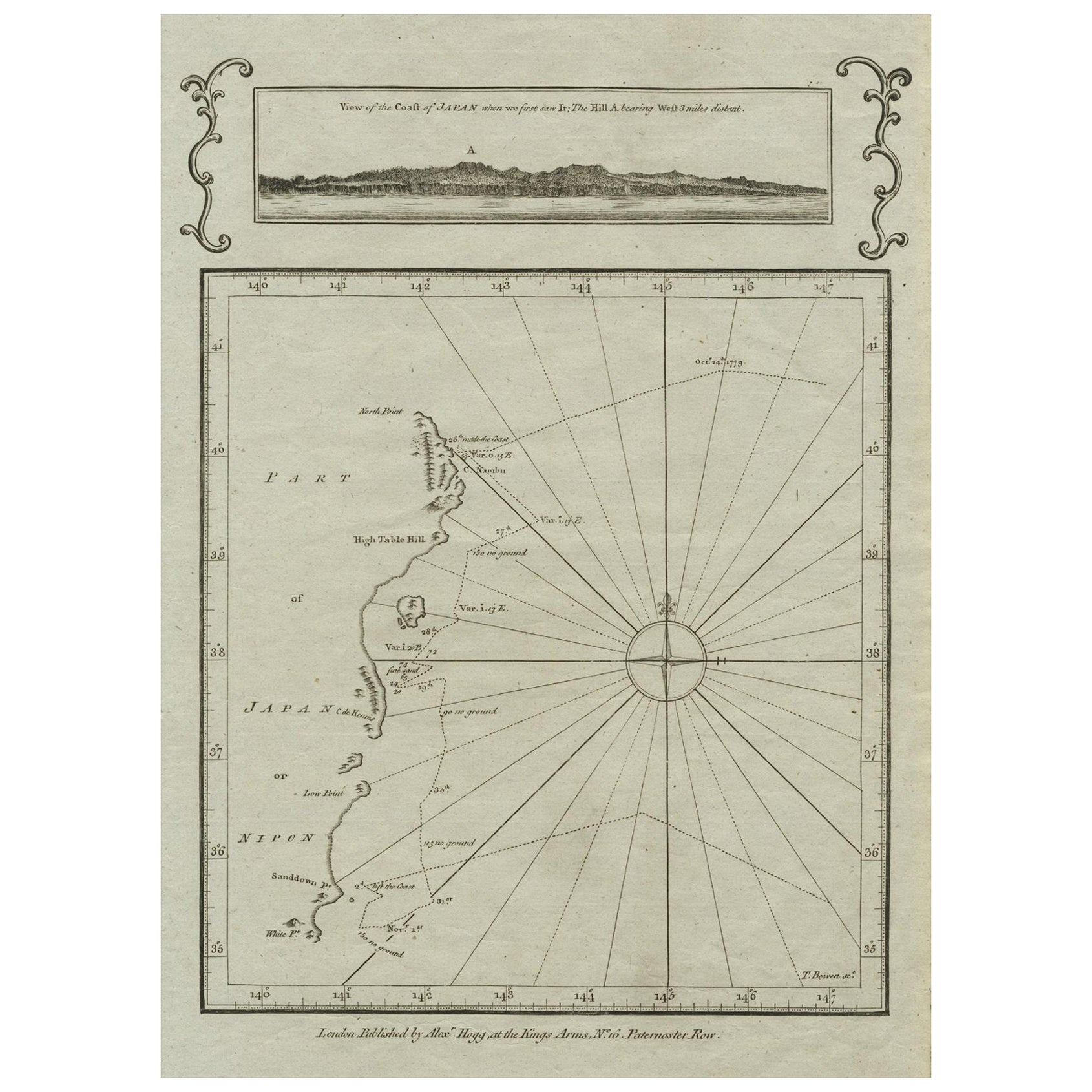
Old Map of the East Coast of Honshu with an Inset, Japan, c.1785
Located in Langweer, NL
Antique map titled ‘Part of Japan or Nippon'.
View of the Coast of Japan when we first saw it: The Hill a bearing West 3 miles distant. London Published by Allexer Hogg at the Kings Arms...
Category
Antique 1780s Maps
Materials
Paper
$210 Sale Price
20% Off
You May Also Like
Original Antique Map of South America. C.1780
Located in St Annes, Lancashire
Great map of South America
Copper-plate engraving
Published C.1780
Two small worm holes to left side of map
Unframed.
Category
Antique Early 1800s English Georgian Maps
Materials
Paper

West Coast of Africa, Guinea & Sierra Leone: An 18th Century Map by Bellin
By Jacques-Nicolas Bellin
Located in Alamo, CA
Jacques Bellin's copper-plate map entitled "Partie de la Coste de Guinee Dupuis la Riviere de Sierra Leona Jusquau Cap das Palmas", depicting the coast of Guinea and Sierra Leone in ...
Category
Antique Mid-18th Century French Maps
Materials
Paper

California, Alaska and Mexico: 18th Century Hand-Colored Map by de Vaugondy
By Didier Robert de Vaugondy
Located in Alamo, CA
This is an 18th century hand-colored map of the western portions of North America entitled "Carte de la Californie et des Pays Nord-Ouest separés de l'Asie par le détroit d'Anian, ex...
Category
Antique 1770s French Maps
Materials
Paper

Original Antique Map of Switzerland, Engraved By Barlow, Dated 1807
Located in St Annes, Lancashire
Great map of Switzerland
Copper-plate engraving by Barlow
Published by Brightly & Kinnersly, Bungay, Suffolk.
Dated 1807
Unframed.
Category
Antique Early 1800s English Maps
Materials
Paper

Original Antique Map of The World by Thomas Clerk, 1817
Located in St Annes, Lancashire
Great map of The Eastern and Western Hemispheres
On 2 sheets
Copper-plate engraving
Drawn and engraved by Thomas Clerk, Edinburgh.
Published by Mackenzie And Dent, 1817
...
Category
Antique 1810s English Maps
Materials
Paper

1654 Joan Blaeu Map the Sutherland, Scotland, Entitled "Southerlandia, "Ric0007
Located in Norton, MA
1654 Joan Blaeu map of the
Sutherland, Scotland, entitled
"Southerlandia,"
Hand Colored
Ric0007
Description:
Lovely map centered on Sedan and D...
Category
Antique 17th Century Dutch Maps
Materials
Paper

More Ways To Browse
Long Island Artists
Vietnam Antiques
Antique Map Vietnam
John Speed Maps
Antique Map Of Turkish Empire
Antique Portuguese Scales
Canadian Atlas Furniture
Prussia Map
Afghanistan Map
Malabar Map
Antique Compass Made In France
Antique Maps Dublin
Antique Newfoundland Canada
John Speed Antique Maps
Malaysia Map
Sebastian Munster
Antique Map Chile
Antique Map Of Boston