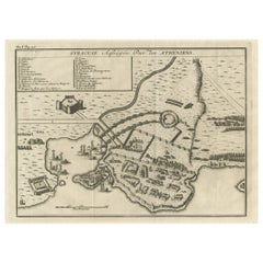
Items Similar to Antique Map of the Siege of Syracuse by the Athenians, 1648 – Thucydides

Video Loading
Want more images or videos?
Request additional images or videos from the seller
1 of 11
Antique Map of the Siege of Syracuse by the Athenians, 1648 – Thucydides
$706.78
$883.4820% Off
£521.25
£651.5620% Off
€592
€74020% Off
CA$976.88
CA$1,221.1020% Off
A$1,086.36
A$1,357.9520% Off
CHF 570.19
CHF 712.7420% Off
MX$13,247.62
MX$16,559.5220% Off
NOK 7,206.11
NOK 9,007.6320% Off
SEK 6,756.01
SEK 8,445.0220% Off
DKK 4,506.99
DKK 5,633.7420% Off
About the Item
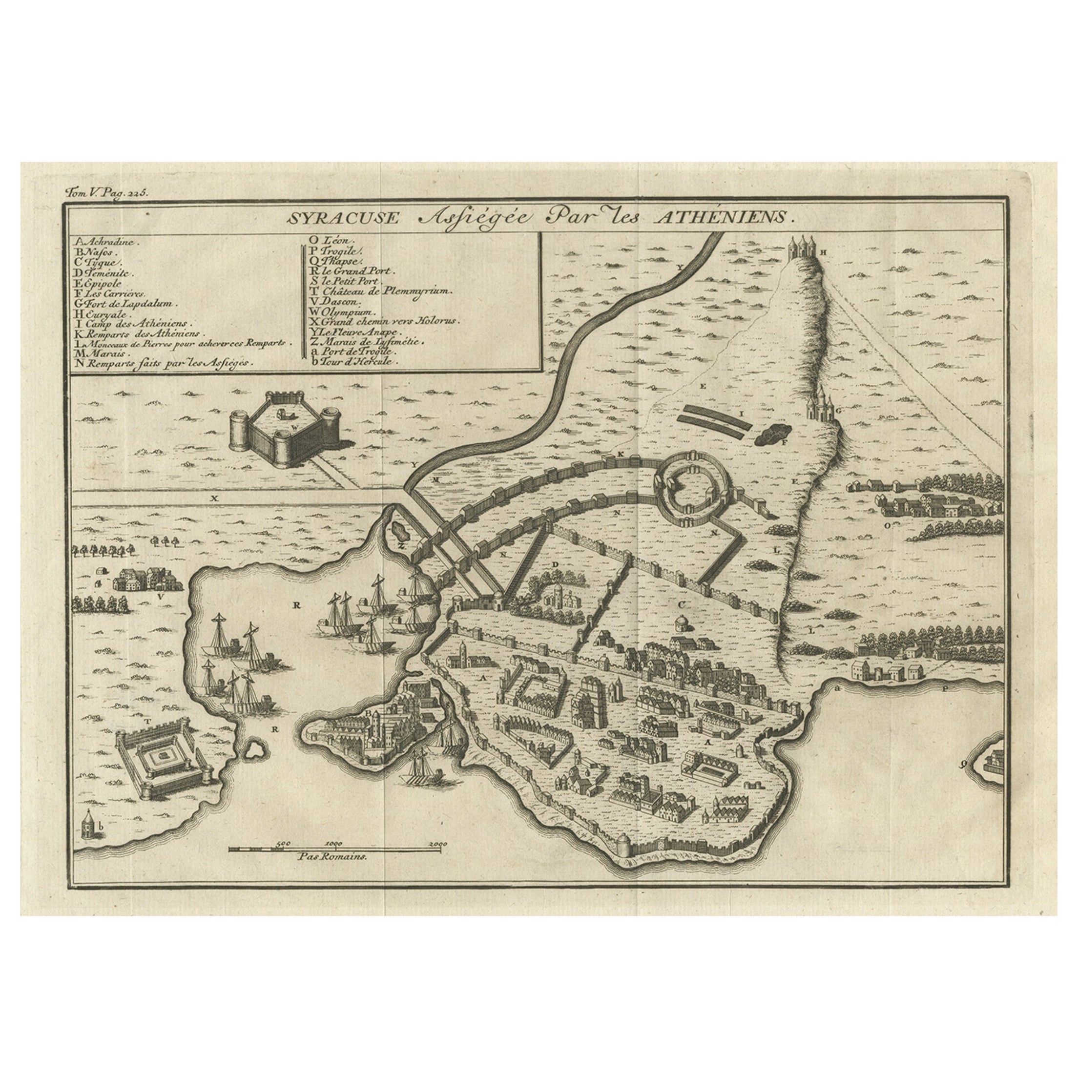
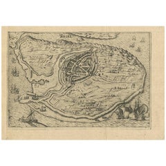
Antique Map of the Siege of Syracuse by the Athenians, 1648 – Thucydides
This finely engraved plan depicts the Siege of Syracuse, one of the most dramatic episodes of the Peloponnesian War (431–404 BC), fought between Athens and Sparta. Shown is the city of Syracuse on the island of Sicily under assault by the Athenians, with fortifications, harbors, camps, ships, and strategic positions all carefully marked. A lettered key at upper left identifies important landmarks, including the Great Harbor, the Olympieum, the river Anapus, and the walls and siege works built by the Athenians.
The map was published in the 1648 London edition of Eight Bookes of the Peloponnesian Warre by Thucydides, translated by the philosopher Thomas Hobbes (1588–1679). Hobbes’ translation, first issued in 1629, was among the earliest English renderings of Thucydides’ history and reflected his deep interest in politics and the dangers of civil conflict. This 1648 edition was richly illustrated with engraved maps and plans to help readers visualize the key battles and sieges of the war.
The Siege of Syracuse (415–413 BC) was a turning point in the Peloponnesian War. Athens launched a massive expedition to capture Syracuse, but after prolonged fighting, the Syracusans, aided by Spartan forces, defeated the Athenians. The failure of the Sicilian Expedition severely weakened Athens and contributed to its ultimate defeat by Sparta.
This map is not only a striking visual artifact of 17th-century scholarship but also an important historical document that connects Hobbes’ political thought with classical history. Maps from this edition are now scarce and highly sought after by collectors of antiquarian maps, early printed books, and works of classical history.
Condition: Very good condition. Minor age-related toning and light spotting, minor edge wear, and handling marks. Strong impression with good detail.
Framing tips: A classic dark frame with a warm cream or off-white mount will highlight the age and character of the engraving, while a gilt frame adds a more dramatic, museum-like presentation.
Technique: Engraving
Maker: Anonymous, published in Thomas Hobbes’ Thucydides, London 1648
- Dimensions:Height: 12.6 in (32 cm)Width: 15.56 in (39.5 cm)Depth: 0 in (0.02 mm)
- Materials and Techniques:Paper,Engraved
- Place of Origin:
- Period:Mid-17th Century
- Date of Manufacture:circa 1648
- Condition:Condition: Very good condition. Minor age-related toning and light spotting, minor edge wear, and handling marks. Strong impression with good detail.
- Seller Location:Langweer, NL
- Reference Number:Seller: PCT-62746 1stDibs: LU3054327345352
About the Seller
5.0
Recognized Seller
These prestigious sellers are industry leaders and represent the highest echelon for item quality and design.
Platinum Seller
Premium sellers with a 4.7+ rating and 24-hour response times
Established in 2009
1stDibs seller since 2017
2,577 sales on 1stDibs
Typical response time: <1 hour
- ShippingRetrieving quote...Shipping from: Langweer, Netherlands
- Return Policy
Authenticity Guarantee
In the unlikely event there’s an issue with an item’s authenticity, contact us within 1 year for a full refund. DetailsMoney-Back Guarantee
If your item is not as described, is damaged in transit, or does not arrive, contact us within 7 days for a full refund. Details24-Hour Cancellation
You have a 24-hour grace period in which to reconsider your purchase, with no questions asked.Vetted Professional Sellers
Our world-class sellers must adhere to strict standards for service and quality, maintaining the integrity of our listings.Price-Match Guarantee
If you find that a seller listed the same item for a lower price elsewhere, we’ll match it.Trusted Global Delivery
Our best-in-class carrier network provides specialized shipping options worldwide, including custom delivery.More From This Seller
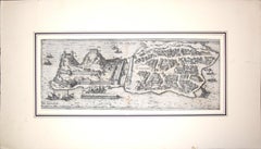
View AllOld Copper Engraving of the Siege of Syracuse, Sicily, Italy, Published, ca.1740
Located in Langweer, NL
Antique print titled 'Syracuse, Assiégée par les Atheniens'.
Old print of the siege of Syracuse, Sicily, Italy. Source unknown, to be determined.
The siege of Syracuse by the...
Category
Antique 1740s Maps
Materials
Paper
$267 Sale Price
20% Off
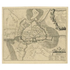
Antique Map of The Siege of Gennep, the Netherlands, c.1650
Located in Langweer, NL
Antique map titled 'Belagerung des Besten Schloss und Passes Gennep'. Old map of the Siege of Gennep, the Netherlands. This map originates from 'Theatrum Europaeum' by M. Merian. Art...
Category
Antique 17th Century Maps
Materials
Paper

$229 Sale Price
20% Off
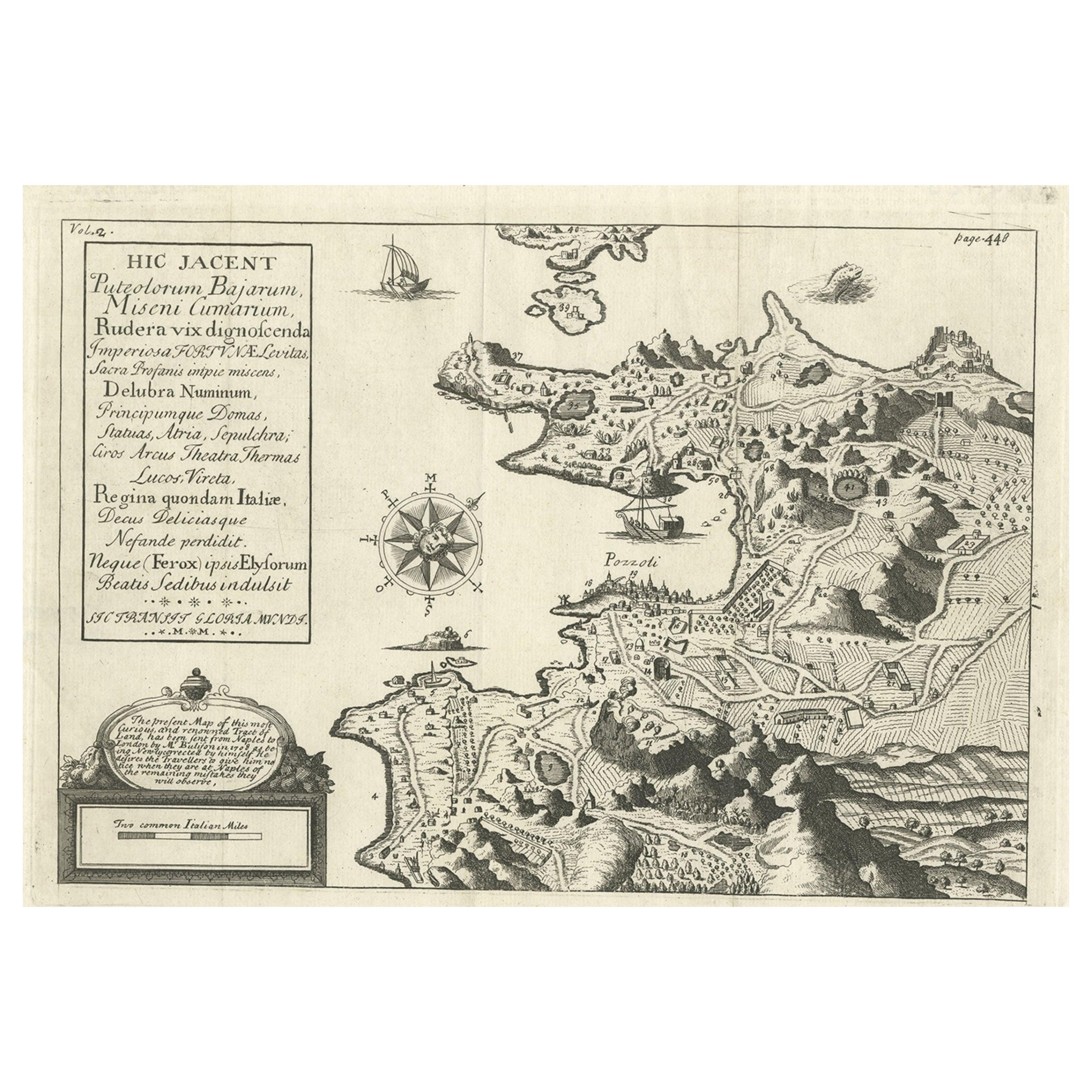
Old Original Map of Pozzuoli Near Naples in the Campania Region, Italy, ca.1740
Located in Langweer, NL
Antique map titled 'Hic Jacent Puteolorum Bajarum (..)'. Old map of the region of Pozzuoli showing the topographic and architectural features of interest. Pozzuoli is a city and comu...
Category
Antique 1740s Maps
Materials
Paper

$334 Sale Price
20% Off
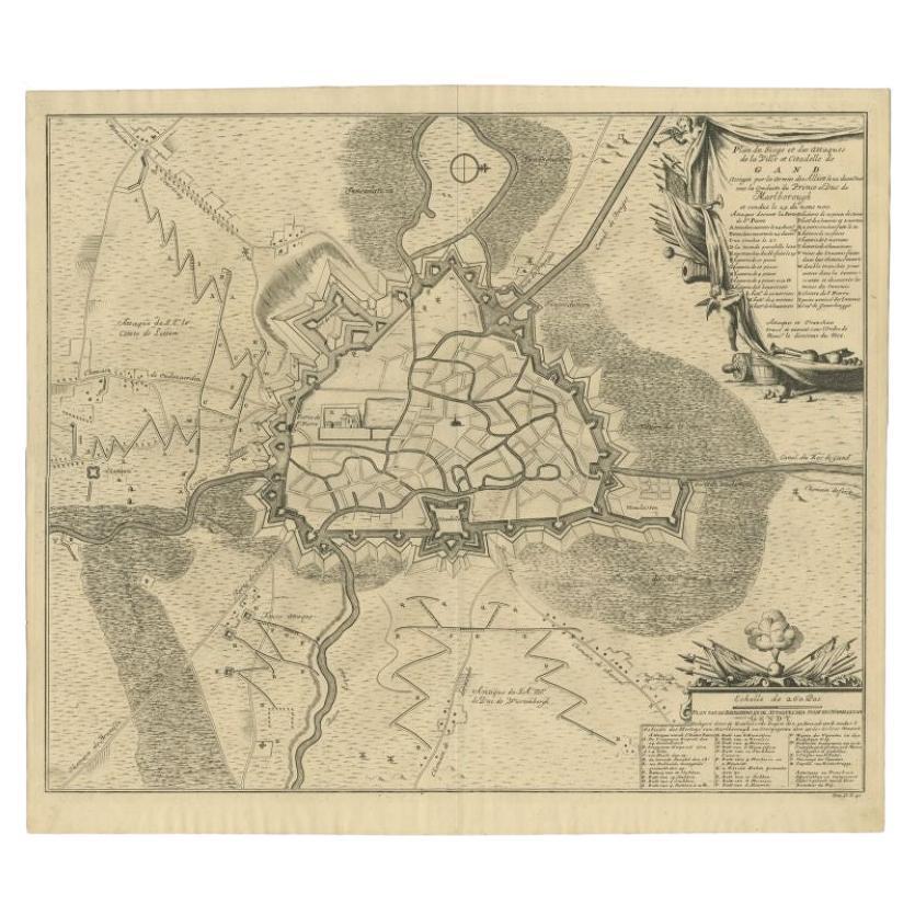
Antique Map of the Siege of Gent by Dumont, 1729
By Dumont
Located in Langweer, NL
Antique map titled 'Plan of the Siege and Attacks of the City and Citadel of Ghent'. Large map depicting the siege of the Belgian city of Gent in 1708 during the war of the Spanish S...
Category
Antique 18th Century Maps
Materials
Paper
$319 Sale Price
20% Off
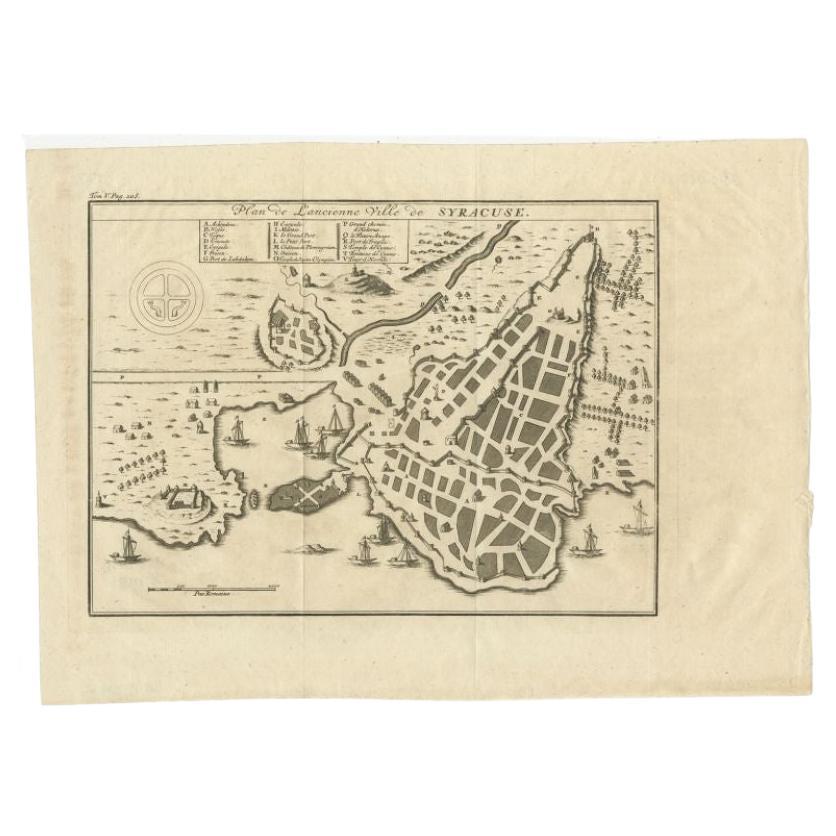
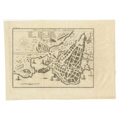
Antique Plan of Ancient Syracuse, cicily, Italy, 1740
Located in Langweer, NL
Antique print titled 'Plan de l'Ancienne Ville de Syracuse'. Plan of ancient Syracuse, Sicily, Italy. Source unknown, to be determined.
Artists and Engravers: Anonymous.
Condit...
Category
Antique 18th Century Maps
Materials
Paper
$276 Sale Price
20% Off
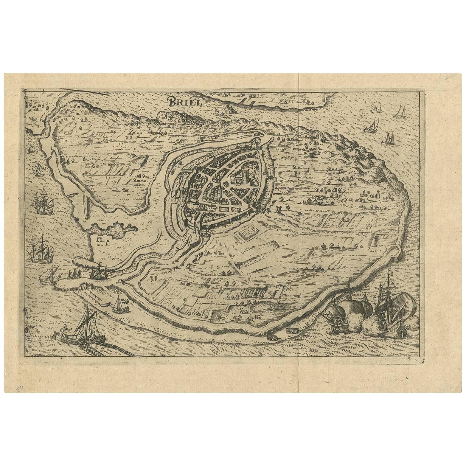
Antique Map of the City of Brielle 'The Netherlands' by L. Guicciardini, 1625
Located in Langweer, NL
Plan of Brielle, Briel, Den Briel in the Province of Zuid-Holland, The Netherlands, Holland. This map originates from the 1625 edition of 'Discrittione di tutti i Paesi Bassi', by L....
Category
Antique Early 17th Century Maps
Materials
Paper
$171 Sale Price
20% Off
You May Also Like
1597 German Map of Alexandria by Georg Braun and Frans Hogenberg
By Georg Braun and Frans Hogenberg
Located in Chapel Hill, NC
1597 Map of Alexandria by Georg Braun and Frans Hogenberg, Germany. From "Civitas Orbis Terrarum", part 2, published in Cologne by Bertram Buchholz. Printed in 2 parts. Title: "Alexa...
Category
Antique 16th Century German Renaissance Maps
Materials
Paper

18th Century Map Engraving - Plan of the Works of the City of Messina, Sicily
Located in Corsham, GB
A map of Messina, a harbour city in northeast Sicily. Inscribed with the title in plate to the lower edge, 'Plan of the Works of the City of Messina, one of the strongest and most co...
Category
18th Century More Prints
Materials
Engraving

$285 Sale Price
20% Off
1646 Jansson Map Entitled "Procinvia Connactiae, " Ric.a006
Located in Norton, MA
1646 Jansson map entitled
"Procinvia connactiae,"
Ric.a006
Description: The PROVINCE of CONNAVGT 490 x 380From vol 4 of Jansson's Atlas Novus 1646, published in Amsterdam with...
Category
Antique 17th Century Unknown Maps
Materials
Paper

Corfu, Big Antique Map from "Civitates Orbis Terrarum" - 1572-1617
By Franz Hogenberg
Located in Roma, IT
Braun G. and Hogenberg F., Corfu, from the collection Civitates Orbis Terrarum, Cologne, T. Graminaeus, 1572-1617. Image dimensions: cm 19 x 48; dimensions: cm 40 x 70.
Very lovely ...
Category
16th Century Landscape Prints
Materials
Etching
17th Century Toulouse, Savve, Sommieres Topographical Map by Iohan Peeters
Located in New York, NY
Fine topographical 17th century map of Toulouse, Savve and Sommieres by Iohan Peeters
Beautiful engraving of the capital of France's Occitanie Region, Toulouse, called La Ville Rose- the Pink City, for the terracotta bricks used in its many buildings, giving the city a distinct apricot-rose hue. An important cultural and educational center, the city's residents included Nobel Prize winners and world renown artists- Henri de Toulouse-Lautrec, Henri Martin, Jean-Auguste-Dominique Ingres, Antonin Mercie, Alexandre Falguiere and more recently Cyril Kongo...
Category
Antique 17th Century Dutch Maps
Materials
Paper

17th-18th Century Siege of Graves Mapping Engraving By Willian III
Located in Kingston, NY
RARE French 17th-18th Century Enhanced Siege of Graves Mapping Engraving BY William III, also widely known as William of Orange,
The Siege of Grave in Dutch Brabant started by Monsie...
Category
Antique 17th Century French Prints
Materials
Paper

More Ways To Browse
Siege Antique
Syracuse Used Furniture
Ptolemy Map
Map Of Jerusalem
1820 World Map
Cyprus Antique Maps
Antique Ecuador
Antique Map Of Thailand
Antique Mississippi Map
Antique Ohio Maps
Burgundy Map
John Speed Maps
Antique Map Of Turkish Empire
Antique Portuguese Scales
Canadian Atlas Furniture
Prussia Map
Afghanistan Map
Malabar Map