Items Similar to Antique Map of Taluti Bay by Stemler, C.1875


Want more images or videos?
Request additional images or videos from the seller
1 of 5
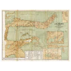
Antique Map of Taluti Bay by Stemler, C.1875
$118
$147.5020% Off
£87.78
£109.7220% Off
€98.40
€12320% Off
CA$161.58
CA$201.9820% Off
A$179.66
A$224.5720% Off
CHF 93.81
CHF 117.2620% Off
MX$2,186.86
MX$2,733.5720% Off
NOK 1,196.93
NOK 1,496.1720% Off
SEK 1,121.47
SEK 1,401.8420% Off
DKK 749.06
DKK 936.3320% Off
Shipping
Retrieving quote...The 1stDibs Promise:
Authenticity Guarantee,
Money-Back Guarantee,
24-Hour Cancellation
About the Item
Antique map titled 'Kaart der Teloeti Baai op Ceram.' This scarce map shows the Taluti Bay on the Moluccan island of Ceram. Originates from 'Tijdschrift Aardrijkskundig Genootschap', published by C. F. Stemler in Amsterdam, ca. 1875. Artists and Engravers: Map by C.B.M. von Rosenberg. Lithographed by J. Postma.
Artist: Map by C.B.M. von Rosenberg. Lithographed by J. Postma.
Condition: Good, general age related toning; some light staining from handling.
Date: c.1875
Overall size: 76 x 27.5 cm.
Image size: 0.001 x 73.5 x 25 cm.
Antique prints have long been appreciated for both their aesthetic and investment value. They were the product of engraved, etched or lithographed plates. These plates were handmade out of wood or metal, which required an incredible level of skill, patience and craftsmanship. Whether you have a house with Victorian furniture or more contemporary decor an old engraving can enhance your living space.
- Dimensions:Height: 10.83 in (27.5 cm)Width: 29.93 in (76 cm)Depth: 0 in (0.01 mm)
- Materials and Techniques:
- Period:
- Date of Manufacture:circa 1875
- Condition:
- Seller Location:Langweer, NL
- Reference Number:Seller: PCT-145341stDibs: LU3054327773822
About the Seller
5.0
Recognized Seller
These prestigious sellers are industry leaders and represent the highest echelon for item quality and design.
Platinum Seller
Premium sellers with a 4.7+ rating and 24-hour response times
Established in 2009
1stDibs seller since 2017
2,511 sales on 1stDibs
Typical response time: <1 hour
- ShippingRetrieving quote...Shipping from: Langweer, Netherlands
- Return Policy
Authenticity Guarantee
In the unlikely event there’s an issue with an item’s authenticity, contact us within 1 year for a full refund. DetailsMoney-Back Guarantee
If your item is not as described, is damaged in transit, or does not arrive, contact us within 7 days for a full refund. Details24-Hour Cancellation
You have a 24-hour grace period in which to reconsider your purchase, with no questions asked.Vetted Professional Sellers
Our world-class sellers must adhere to strict standards for service and quality, maintaining the integrity of our listings.Price-Match Guarantee
If you find that a seller listed the same item for a lower price elsewhere, we’ll match it.Trusted Global Delivery
Our best-in-class carrier network provides specialized shipping options worldwide, including custom delivery.More From This Seller
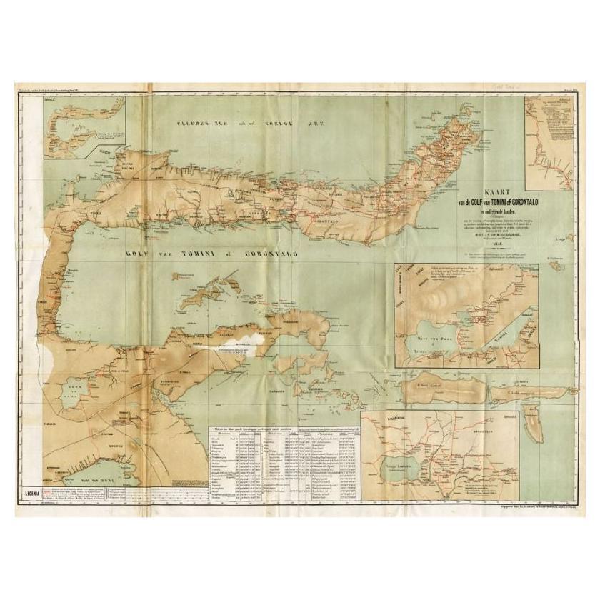
View AllAntique Map of the Gulf of Tomini by Winkler Prins, 1878
Located in Langweer, NL
Antique map titled 'Kaart van de Golf van Tomini of Gorontalo.' (Map of the Gulf of Tomini or Gorontalo.) This map shows the Gulf of Tomini near the Island of Sulawesi, Indonesia. Wi...
Category
Antique 19th Century Maps
Materials
Paper
$177 Sale Price
20% Off
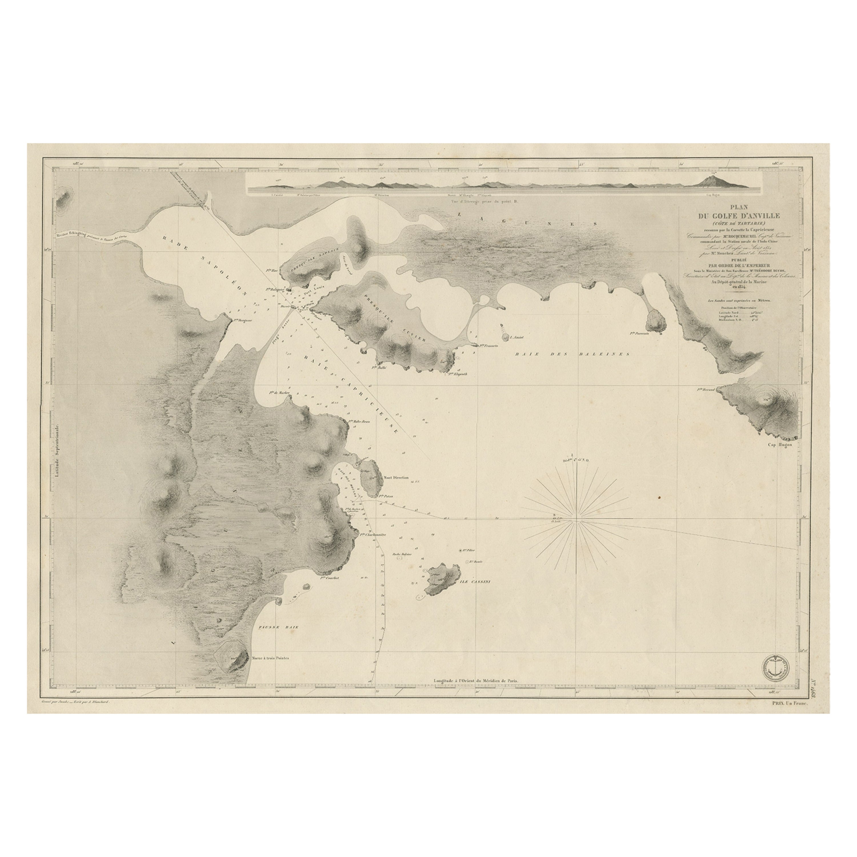
Antique Map of Part of the Chinese Coast, Explored by the French, Ca.1852
Located in Langweer, NL
Antique map titled 'Plan du Golfe D'Anville (Côte de Tartarie)'.
Old map of part of the Chinese coast, explored with the French corvette 'Caprieuse'. The Capricieuse was a late 2...
Category
Antique 1850s Maps
Materials
Paper
$663 Sale Price
34% Off
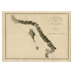
Antique Map of the Coast of New Ireland, Earlier Part of German New Guinea, 1833
Located in Langweer, NL
Antique map titled 'Plan du Havre Carteret sur la Cote occidentale de la Nelle Irlande.
Expedition de la Corvette de S.M. l'Astrolabe, Commandee par le CAP ne de Fregate Dumont D'Urville. Juillet 1827.' A chart of the coast of Latangai Island (then known as New Ireland), with Lamassa Island (identified as Ile Cocos), and a second island identified as Ile Leigh. Shows soundings and height profile. New Ireland, also New Mecklenburg, is the Northeastern Province of Papua New Guinea. Map no. 26 from Dumont D'Urville's "Voyage de la Corvette l'Astrolabe - Atlas"", published in Paris: J. Tastu, 1833.
New Ireland or Latangai, is a large island in Papua New Guinea, approximately 7,404 km2 (2,859 sq mi) in area with c. 120,000 people. It is named after the island of Ireland. It is the largest island of New Ireland Province, lying northeast of the island of New Britain. Both islands are part of the Bismarck Archipelago, named after Otto von Bismarck...
Category
Antique 19th Century Maps
Materials
Paper
Antique Map of Indonesia by C.F. Beautemps-Beaupre, circa 1807
Located in Langweer, NL
Antique map titled 'Carte de la partie du grand archipel d'Asie'. Map of Indonesia showing tracks of Recherche and Esperance in 1792-1793. This map is...
Category
Antique Early 19th Century Maps
Materials
Paper

$719 Sale Price
20% Off
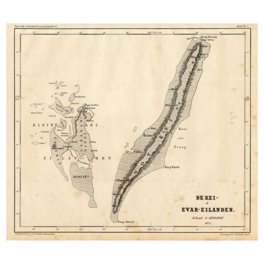
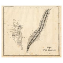
Antique Map of the Kai Islands by Stemler, c.1875
Located in Langweer, NL
Antique map titled 'De Kei- of Evar eilanden.' (Kai Islands.) This map shows the Indonesian Kai Islands. Originates from 'Tijdschrift Aardrijkskundig Genootschap', published by C. F....
Category
Antique 19th Century Maps
Materials
Paper
$60 Sale Price
20% Off
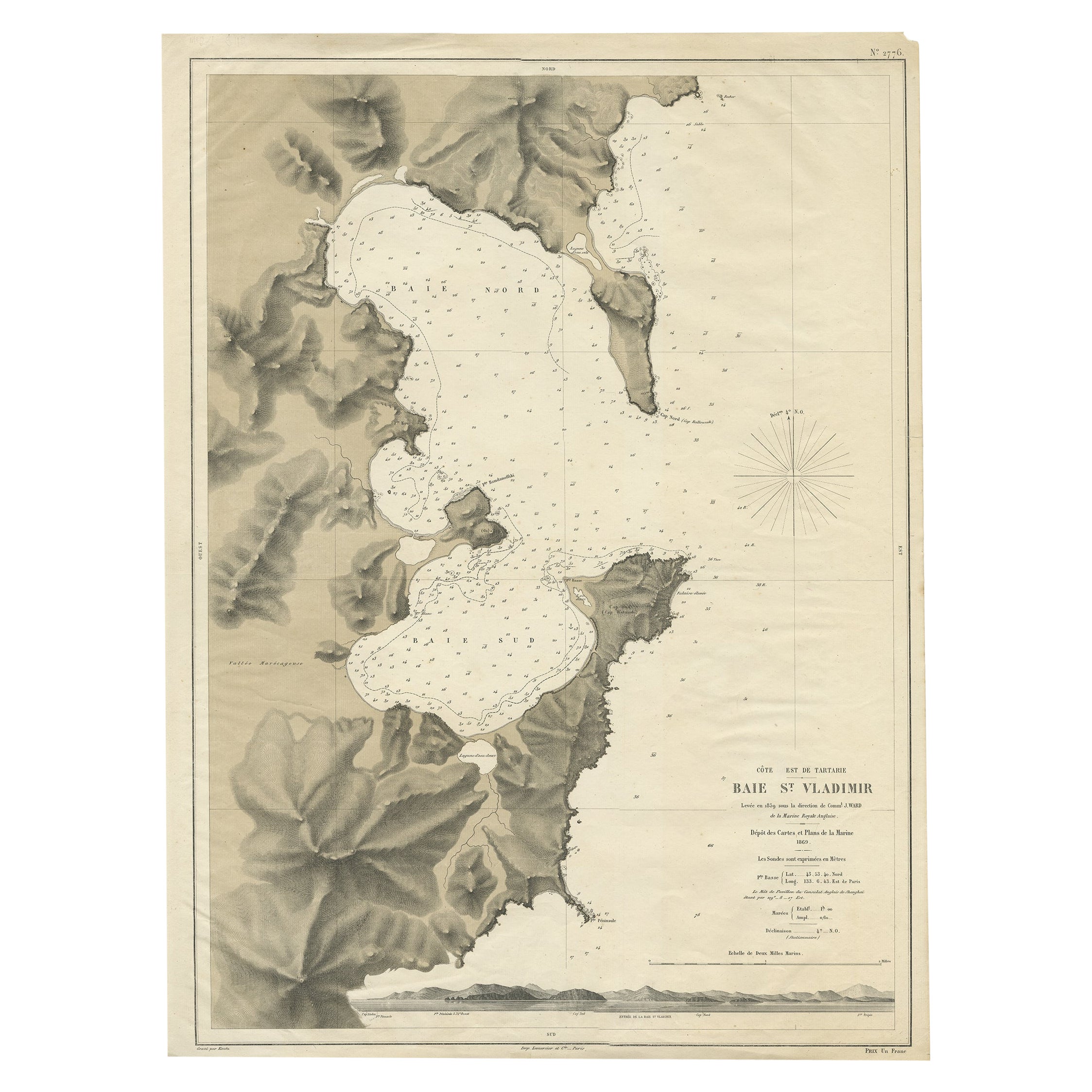
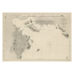
Rare Map of the Bay of St. Vladimir 'Russia' Showing the Route of J. Ward, 1869
Located in Langweer, NL
Antique map titled 'Côte est de Tartarie Baie St. Vladimir'.
Map of the Bay of St. Vladimir (Russia) showing the route of J. Ward. Including a coastal view. Source unknown, to be...
Category
Antique 1860s Maps
Materials
Paper

$700 Sale Price
20% Off
You May Also Like
Large Original Antique Map of The Bahamas. 1894
Located in St Annes, Lancashire
Superb Antique map of The Bahamas
Published Edward Stanford, Charing Cross, London 1894
Original colour
Good condition
Unframed.
Free shipping
Category
Antique 1890s English Maps
Materials
Paper

Scarce U.S. Coast Survey Map Depicting Entrance to San Francisco Bay Dated 1856
Located in San Francisco, CA
A fine example of the 1856 U.S. Coast lithographic survey nautical chart of the entrance to San Francisco bay and the city. Published in 1856 by the Office of the Coast Survey the of...
Category
Antique Mid-19th Century American Maps
Materials
Paper

Large Original Antique Map of The Pacific Ocean, Fullarton, C.1870
Located in St Annes, Lancashire
Great map of The Pacific Ocean
From the celebrated Royal Illustrated Atlas
Lithograph by Swanston. Original color.
Published by Fullarton,...
Category
Antique 1870s Scottish Maps
Materials
Paper

Large Original Antique Map of The West Indies by Sidney Hall, 1847
Located in St Annes, Lancashire
Great map of The West Indies
Drawn and engraved by Sidney Hall
Steel engraving
Original colour outline
Published by A & C Black. 1847
Unframed
Free shipping.
Category
Antique 1840s Scottish Maps
Materials
Paper

Large Original Antique Map of The Greek Islands. 1894
Located in St Annes, Lancashire
Superb Antique map of The Greek Islands
Published Edward Stanford, Charing Cross, London 1894
Original colour
Good condition
Unframed.
Free shipping
Category
Antique 1890s English Maps
Materials
Paper

Large Original Antique Map of The Canary Islands. 1894
Located in St Annes, Lancashire
Superb Antique map of The Canary Islands
Published Edward Stanford, Charing Cross, London 1894
Original colour
Good condition
Unframed.
Free shipping
Category
Antique 1890s English Maps
Materials
Paper
