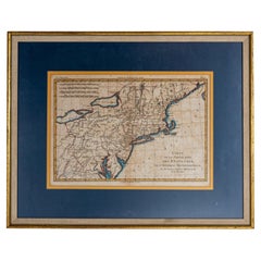
Items Similar to French Framed Copper Engraved Hand Colored Map of Carolina & Georgia, Circa 1757


Want more images or videos?
Request additional images or videos from the seller
1 of 8
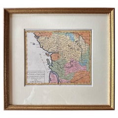
French Framed Copper Engraved Hand Colored Map of Carolina & Georgia, Circa 1757
$2,800
£2,126.11
€2,431.36
CA$3,912.01
A$4,351
CHF 2,271.96
MX$52,947.10
NOK 29,016.39
SEK 27,212.25
DKK 18,146.18
Shipping
Retrieving quote...The 1stDibs Promise:
Authenticity Guarantee,
Money-Back Guarantee,
24-Hour Cancellation
About the Item
French copper engraved hand colored map of Carolina & Georgia matted under glass with a painted frame, mid-18th century
- Dimensions:Height: 14.5 in (36.83 cm)Width: 16.75 in (42.55 cm)Depth: 1 in (2.54 cm)
- Style:Louis XV (Of the Period)
- Materials and Techniques:
- Place of Origin:
- Period:1750-1759
- Date of Manufacture:circa 1757
- Condition:Wear consistent with age and use.
- Seller Location:Charleston, SC
- Reference Number:Seller: # 51911stDibs: LU887228040512
About the Seller
4.7
Vetted Professional Seller
Every seller passes strict standards for authenticity and reliability
Established in 1970
1stDibs seller since 2010
431 sales on 1stDibs
Typical response time: 7 hours
- ShippingRetrieving quote...Shipping from: Charleston, SC
- Return Policy
Authenticity Guarantee
In the unlikely event there’s an issue with an item’s authenticity, contact us within 1 year for a full refund. DetailsMoney-Back Guarantee
If your item is not as described, is damaged in transit, or does not arrive, contact us within 7 days for a full refund. Details24-Hour Cancellation
You have a 24-hour grace period in which to reconsider your purchase, with no questions asked.Vetted Professional Sellers
Our world-class sellers must adhere to strict standards for service and quality, maintaining the integrity of our listings.Price-Match Guarantee
If you find that a seller listed the same item for a lower price elsewhere, we’ll match it.Trusted Global Delivery
Our best-in-class carrier network provides specialized shipping options worldwide, including custom delivery.More From This Seller
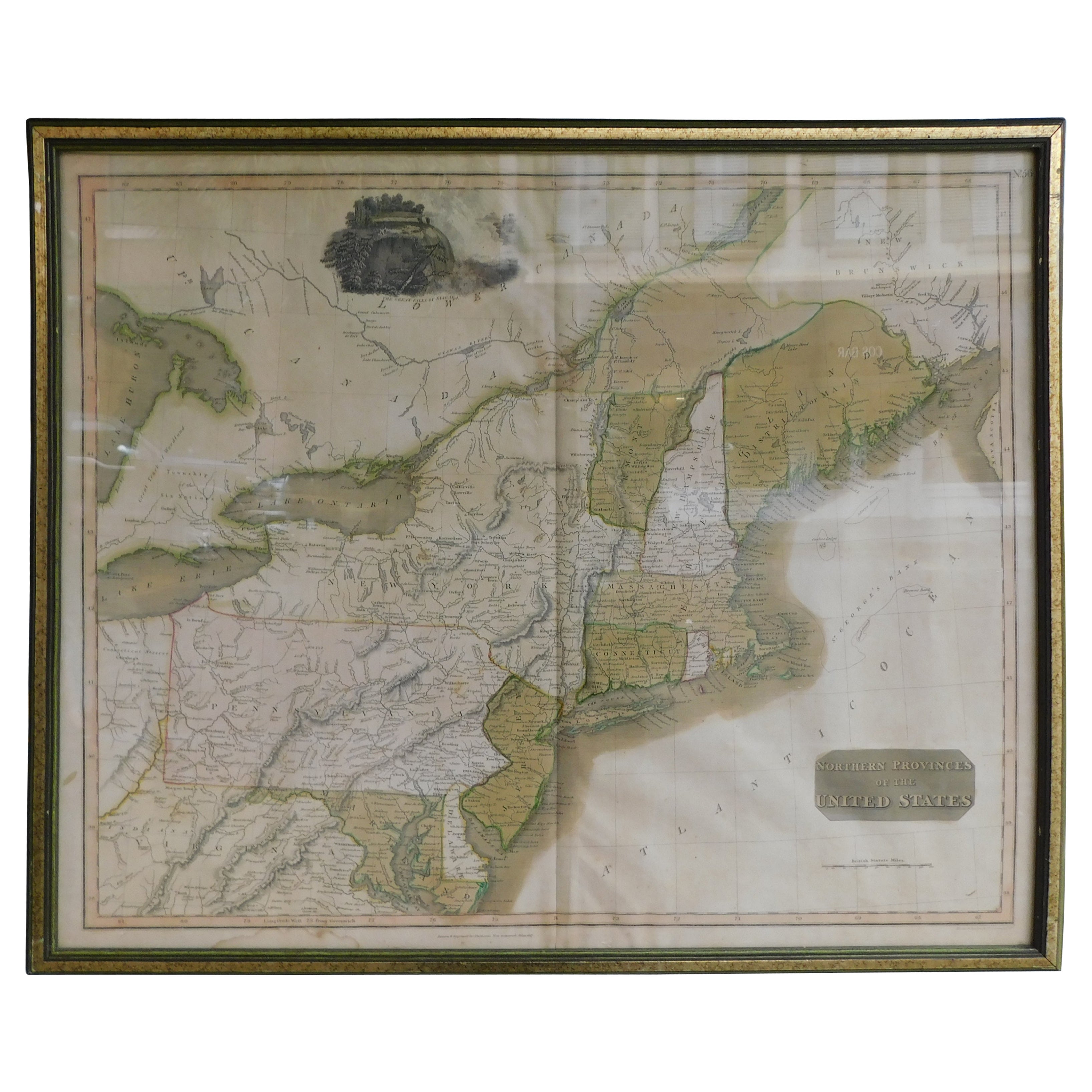
View AllEnglish Engraved Hand Colored Map of the North Eastern United States, circa 1817
Located in Charleston, SC
English copper engraved hand colored map of the North Eastern United States matted under glass in a gilt frame, Early 19th Century. Drawn and Engraved for Thomson's New General Atlas...
Category
Antique 1810s English George III Maps
Materials
Glass, Giltwood, Paint, Paper

American Steel Engraving of George Washington in Orig. Gilt Starred Frame C 1800
By John Trumbull
Located in Charleston, SC
American Steel Engraving of General George Washington "Before the Battle of Trenton" By John Trumbull Under Original Wavy Glass and Thirteen Starred Gilt Frame, Early 19th Century. T...
Category
Antique Early 1800s American American Colonial Drawings
Materials
Steel

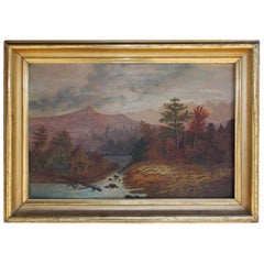
American Oil Framed Landscape on Academy Board, Hudson Valley, Circa 1820
Located in Charleston, SC
American school oil landscape on academy board in the original gold gilt molded frame. Landscape depicts Hudson Valley with mountains in the background, trees in the foreground and a...
Category
Antique 1820s American American Classical Paintings
Materials
Giltwood
Pair of John Gould Hand Colored Framed Lithographs Family of Toucans, Circa 1840
Located in Charleston, SC
Pair of John Gould hand colored framed lithographs family of toucans. "Pteroglossus Inscriptus" and " Pteroglossus Hypoglaurus" Each signed in plate. Printed by Charles Hullmandell. ...
Category
Antique 1840s English William IV Prints
Materials
Glass, Giltwood, Paper

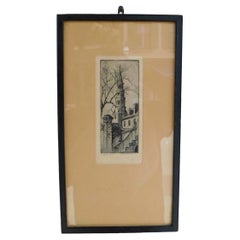
Elizabeth O'Neil Verner Framed Etching St. Phillips Steeple, Charleston, SC 1925
Located in Charleston, SC
Elizabeth O'Neil Verner framed dry point etching of St. Phillips Church Steeple, Charleston, SC. Early 20th Century
Category
Vintage 1920s American Art Nouveau Drawings
Materials
Glass, Wood, Paper
American Oval Pastel of Young Lady Grasping Dove, Cola, SC. Circa 1865
Located in Charleston, SC
American pastel of young lady grasping dove in the original oval floral gilt frame presented under glass, Mid 19th Century. Original paper label on back.
Ursuline Convent, Valle Cru...
Category
Antique 1860s American American Empire Drawings
Materials
Gold Leaf

You May Also Like
South America: Hand-colored 18th Century Framed Map by Thomas Jefferys
By Thomas Jefferys
Located in Alamo, CA
This detailed hand-colored map of South America by Thomas Jefferys was published in London in 1750. The map shows countries, early colonial possessions, towns, rivers, mountains, and...
Category
Antique Mid-18th Century English Maps
Materials
Paper

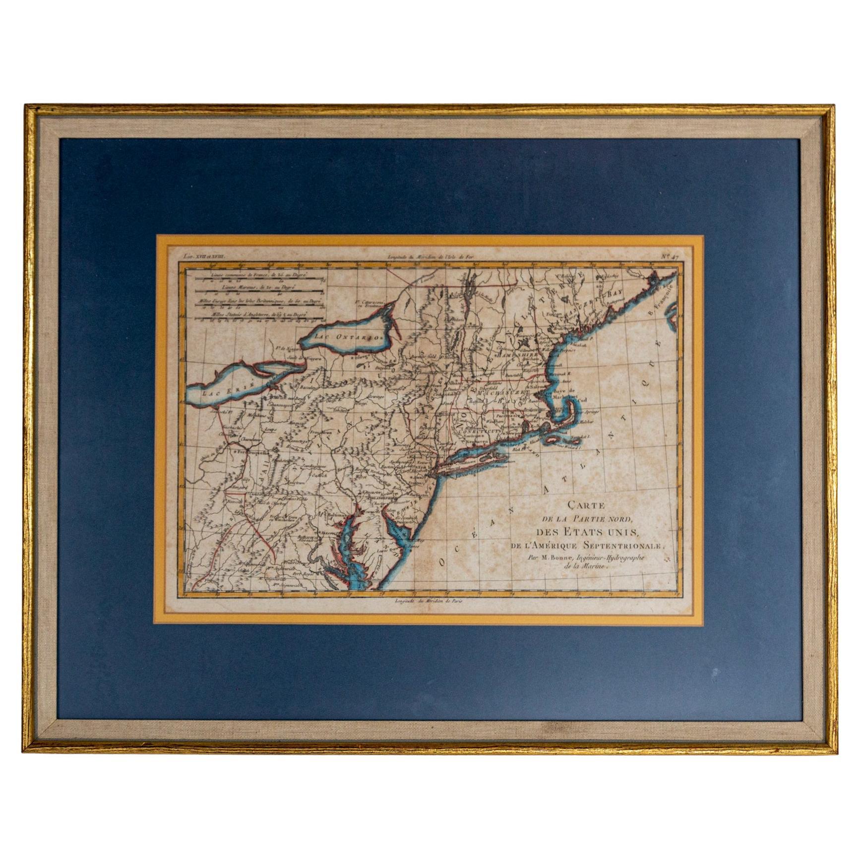
Hand-Colored French Map, Carte des Etats Unis, Par Bonne, Late 18th Century
By Rigobert Bonne
Located in Chappaqua, NY
Hand-colored French map, Carte de la Partie Nord, des Etats Unis, de l'Amérique Septentrionale, late 18th century. A French map of New England published at the end of the Revolutionary War...
Category
Antique Late 18th Century French Louis XVI Prints
Materials
Paper
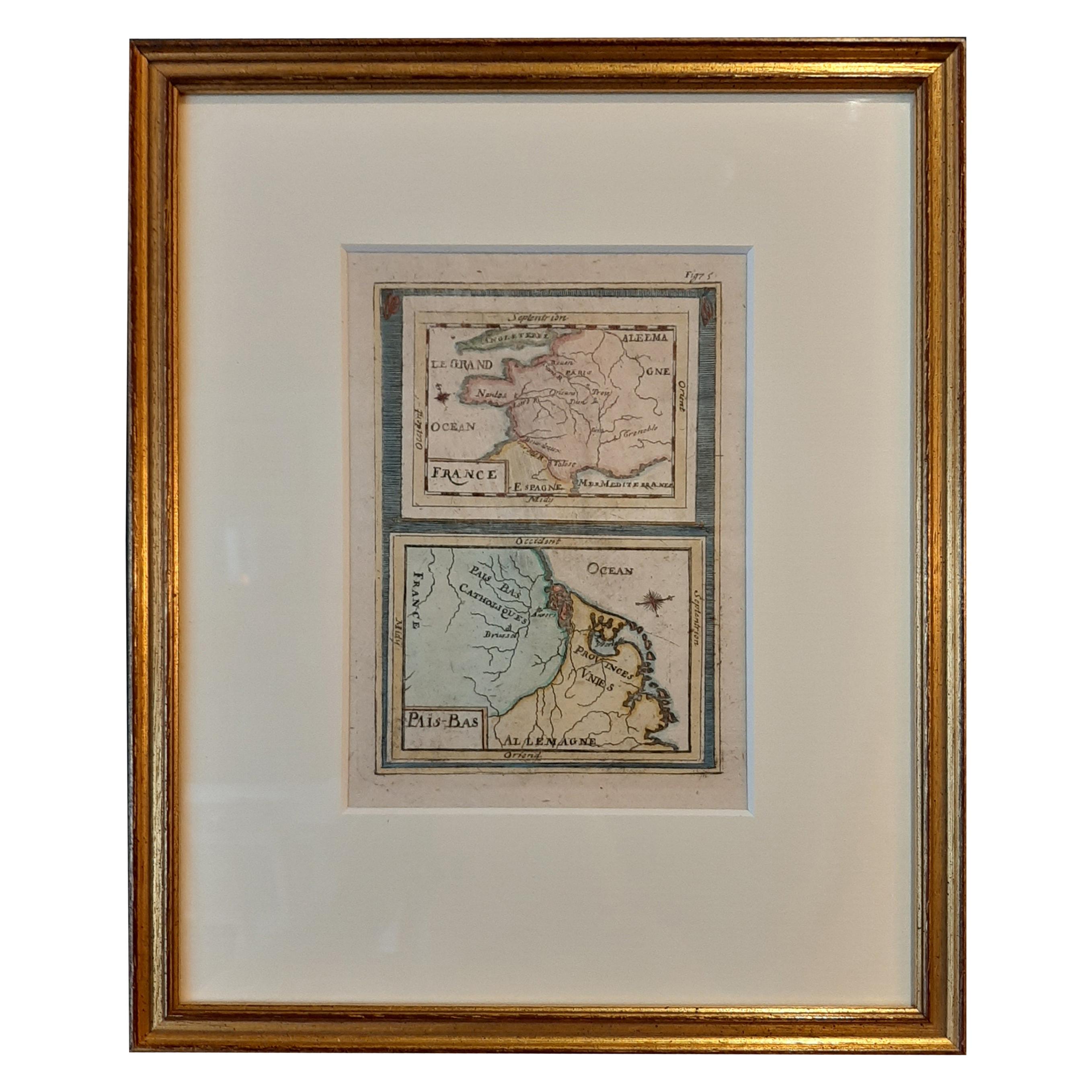
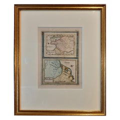
Antique Miniature Map of France and the Low Countries by Mallet, circa 1719
Located in Langweer, NL
Antique map titled 'France - Païs-Bas'. Miniature Map of France and the Low Countries. Published by A.M. Mallet, circa 1719.
Frame included. We carefully pack our framed items to ...
Category
Antique Early 18th Century Maps
Materials
Paper
$167 Sale Price
20% Off
1796 Map of North Carolina by John Reid
Located in Chapel Hill, NC
1796 Map of North Carolina by John Reid. A rare & important early map of the state based on the 1795 Lewis/Carey map for his "An American Atlas". Engraved by Benjamin Tanner. Old pur...
Category
Antique Late 18th Century American Prints
Materials
Paper

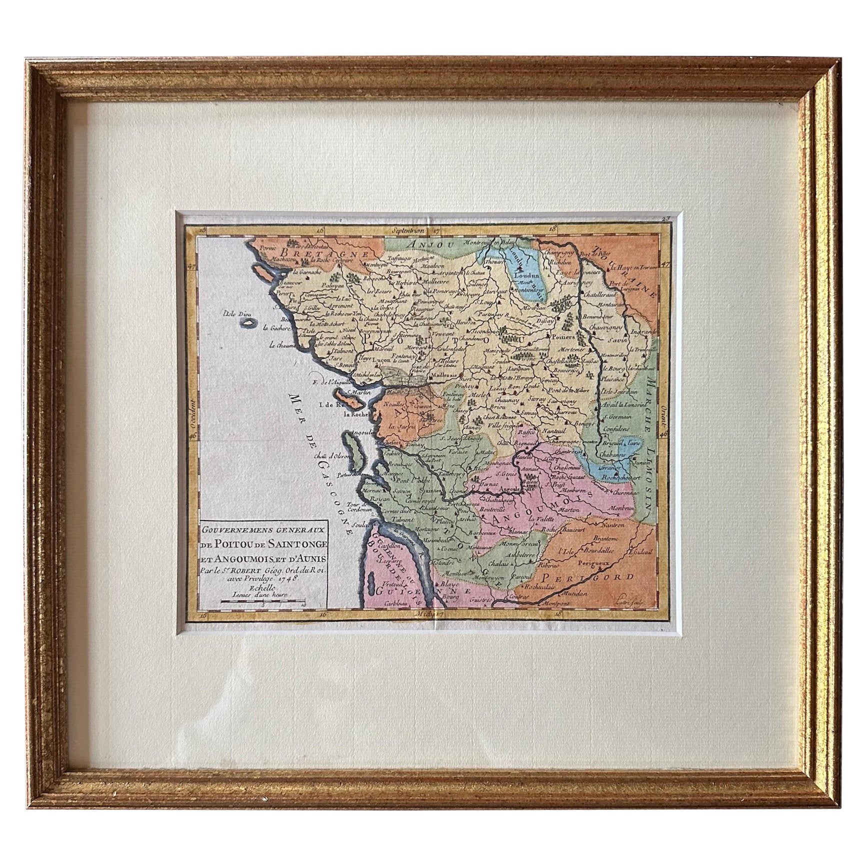
Original Antique Map of West Central France in Frame, 1748
Located in Langweer, NL
A nicely framed and hand-coloured decorative map titled "Gouvernemens Generaux De Poitou et De Saintonge" and engraved by M. Robert. This historical international map includes several specific locations, such as the Isle Dieu, Bretagne, Anjou, Touraine, Angoumois, Perigold, Saintonge, Mer de Gascogne (Bay of Biscay), Poitou, Aunis, Guienne, la Garonne Riviere (Garonne River), and Loudunois, as well as the Tour de Cordouan (Cordouan Lighthouse).
Featured towns on this map include Tonnay, Talmont, Loudun, Mortemer, Poitiers, Chalais, Riberac, Angoule, Marton, Blaye, and Monbrun.
This antique map represents the west-central region of France.
The theme of the atlas from which this map originates is the "Atlas Portatif Universel Et Militaire" by M. Robert. The source description indicates that this atlas is a portable, universal, and military collection...
Category
Antique 1740s Maps
Materials
Paper
$277 Sale Price
20% Off
1705 Golfe de Mexico and Florida Framed Map
Located in Stamford, CT
Framed map of Mexico & Florida circa 1705, Paris. Small map with Mexico and the Gulf Coast. Inset text indicating Panama, Acapulco, Mexico City and the Mississippi. Extends North to ...
Category
Antique Early 1700s French Spanish Colonial Maps
Materials
Glass, Wood, Paper

More Ways To Browse
Antique Copper Frame
18th Century French Copper
Georgian Copper
Caucasus Map
Map Of Puerto Rico
Nevada Antique Map
Shetland Map
Antique Chicago Maps
Kolkata Antique Furniture
Antique Bermuda Furniture
Antique Dairy Collectibles
Antique Map Of Cuba
Antique Map Of Yorkshire
Antique Map Vietnam
Antique Maps Massachusetts
Guyana Antique Map
Peninsular War
Santa Cruz Island