Items Similar to Islands of Fire and Whispers: The Canary Islands in 1902
Want more images or videos?
Request additional images or videos from the seller
1 of 8
Islands of Fire and Whispers: The Canary Islands in 1902
$348.87
$436.0920% Off
£262.77
£328.4620% Off
€296
€37020% Off
CA$481.11
CA$601.3920% Off
A$540.51
A$675.6320% Off
CHF 282.41
CHF 353.0220% Off
MX$6,597.12
MX$8,246.4020% Off
NOK 3,585.84
NOK 4,482.3120% Off
SEK 3,375.32
SEK 4,219.1520% Off
DKK 2,253.04
DKK 2,816.3020% Off
About the Item
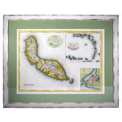
This is a authentic historical map of the Canary Islands, specifically the "1A HOJA" or first sheet, from the year 1902. The title on the map is "ISLAS CANARIAS 1902." This map features several of the main islands of the archipelago, including Tenerife, La Palma, La Gomera, and El Hierro.
The map includes topographical details with contour lines and color gradations to indicate varying elevations. There are symbols for provincial capitals, towns, roads, telegraph stations, and lighthouses. The Canary Islands are located in the Atlantic Ocean, off the northwest coast of Africa, and are known for their volcanic landscapes, diverse ecosystems, and rich cultural history.
Some notable features of the Canary Islands include:
1. **Teide Volcano**: Located on Tenerife, the Teide is the highest peak in Spain and the third highest volcano in the world measured from its base on the ocean floor.
2. **Biodiversity**: The islands are home to a wide range of microclimates and ecosystems, from subtropical forests to desert areas, hosting many unique plant and animal species.
3. **Cultural Fusion**: The culture of the Canary Islands is a mix of Spanish, African, and indigenous Guanche influences, reflected in their music, food, and traditions.
4. **Astronomical Observatories**: The clear skies of the Canary Islands make them an ideal location for astronomical observatories, including the Roque de los Muchachos Observatory on La Palma and the Teide Observatory on Tenerife.
5. **Laurel Forests**: The laurisilva or laurel forests on La Gomera and La Palma are ancient woodlands that date back to the Tertiary period.
6. **Beaches and Tourism**: The islands are famous for their beautiful beaches, attracting millions of tourists every year to resorts and natural spaces alike.
7. **Whistling Language**: On La Gomera, there is a unique whistled language called Silbo Gomero, which is used to communicate across the deep valleys and ravines.
8. **Pre-Hispanic History**: The indigenous Guanche people left behind a rich archaeological heritage, including the pyramids of Güímar on Tenerife and the cave paintings of La Palma.
"Islands of Fire and Whispers: The Canary Islands in 1902"
This title hints at the volcanic nature of the islands and the unique Silbo Gomero, capturing the essence of their geographical and cultural character.
- Dimensions:Height: 14.77 in (37.5 cm)Width: 20.08 in (51 cm)Depth: 0 in (0.02 mm)
- Materials and Techniques:
- Period:1900-1909
- Date of Manufacture:1902
- Condition:Good condition. Central vertical folding lines as issued. Aged paper with typically warm, yellowish-brown hue, especially around the edges and folding lines, adding to its patina. Check the images carefully.
- Seller Location:Langweer, NL
- Reference Number:Seller: BG-13642-491stDibs: LU3054338034152
About the Seller
5.0
Recognized Seller
These prestigious sellers are industry leaders and represent the highest echelon for item quality and design.
Platinum Seller
Premium sellers with a 4.7+ rating and 24-hour response times
Established in 2009
1stDibs seller since 2017
2,534 sales on 1stDibs
Typical response time: <1 hour
- ShippingRetrieving quote...Shipping from: Langweer, Netherlands
- Return Policy
Authenticity Guarantee
In the unlikely event there’s an issue with an item’s authenticity, contact us within 1 year for a full refund. DetailsMoney-Back Guarantee
If your item is not as described, is damaged in transit, or does not arrive, contact us within 7 days for a full refund. Details24-Hour Cancellation
You have a 24-hour grace period in which to reconsider your purchase, with no questions asked.Vetted Professional Sellers
Our world-class sellers must adhere to strict standards for service and quality, maintaining the integrity of our listings.Price-Match Guarantee
If you find that a seller listed the same item for a lower price elsewhere, we’ll match it.Trusted Global Delivery
Our best-in-class carrier network provides specialized shipping options worldwide, including custom delivery.More From This Seller
View AllVolcanic Eden: The Canary Islands’ Tapestry of Land and Sea in 1902
Located in Langweer, NL
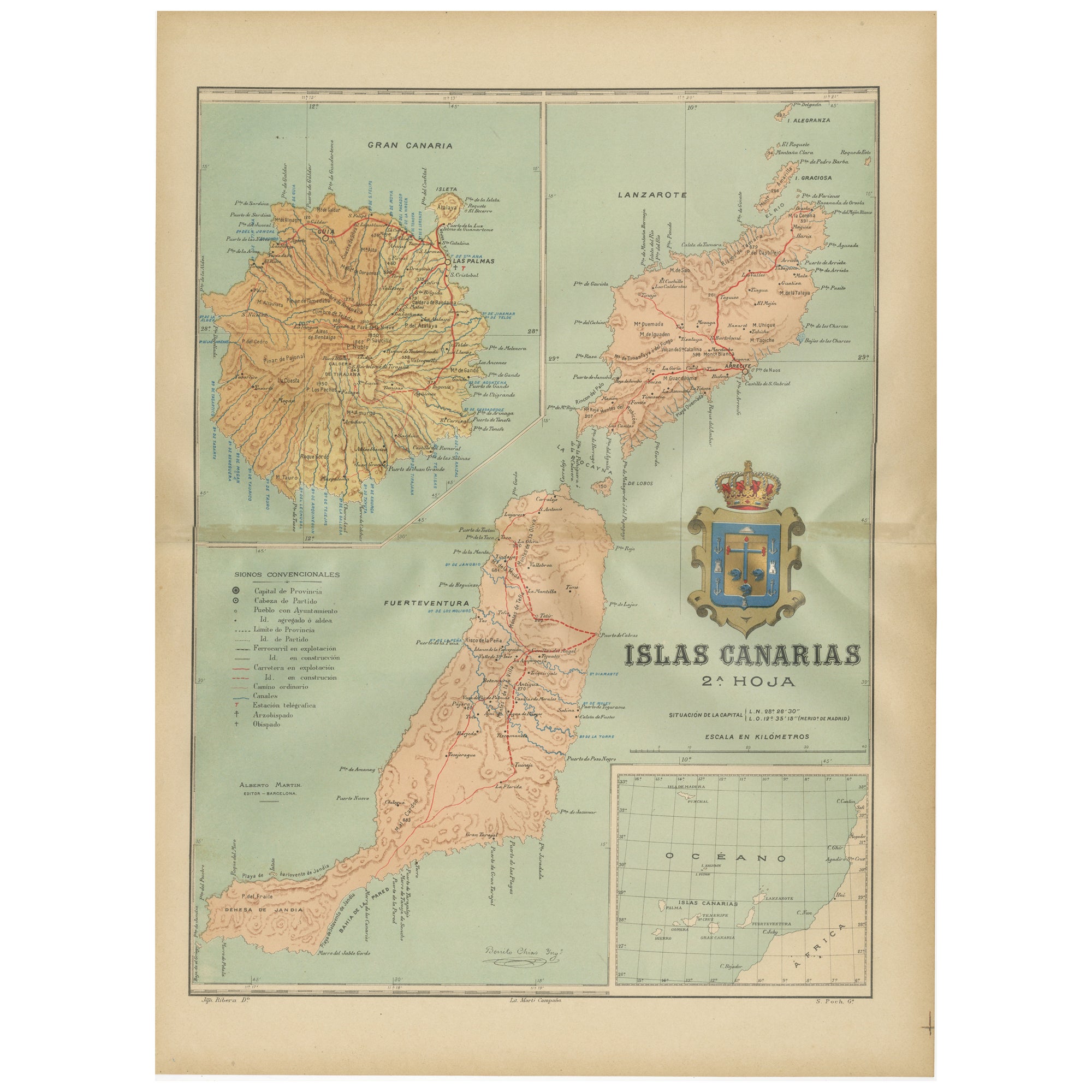
The map is the second sheet (2ª HOJA) of a historical map series of the Canary Islands from 1902. It depicts three of the major islands: Gran Canaria, Fuerteventura, and Lanzarote, a...
Category
Antique Early 1900s Maps
Materials
Paper
$348 Sale Price
20% Off
Free Shipping
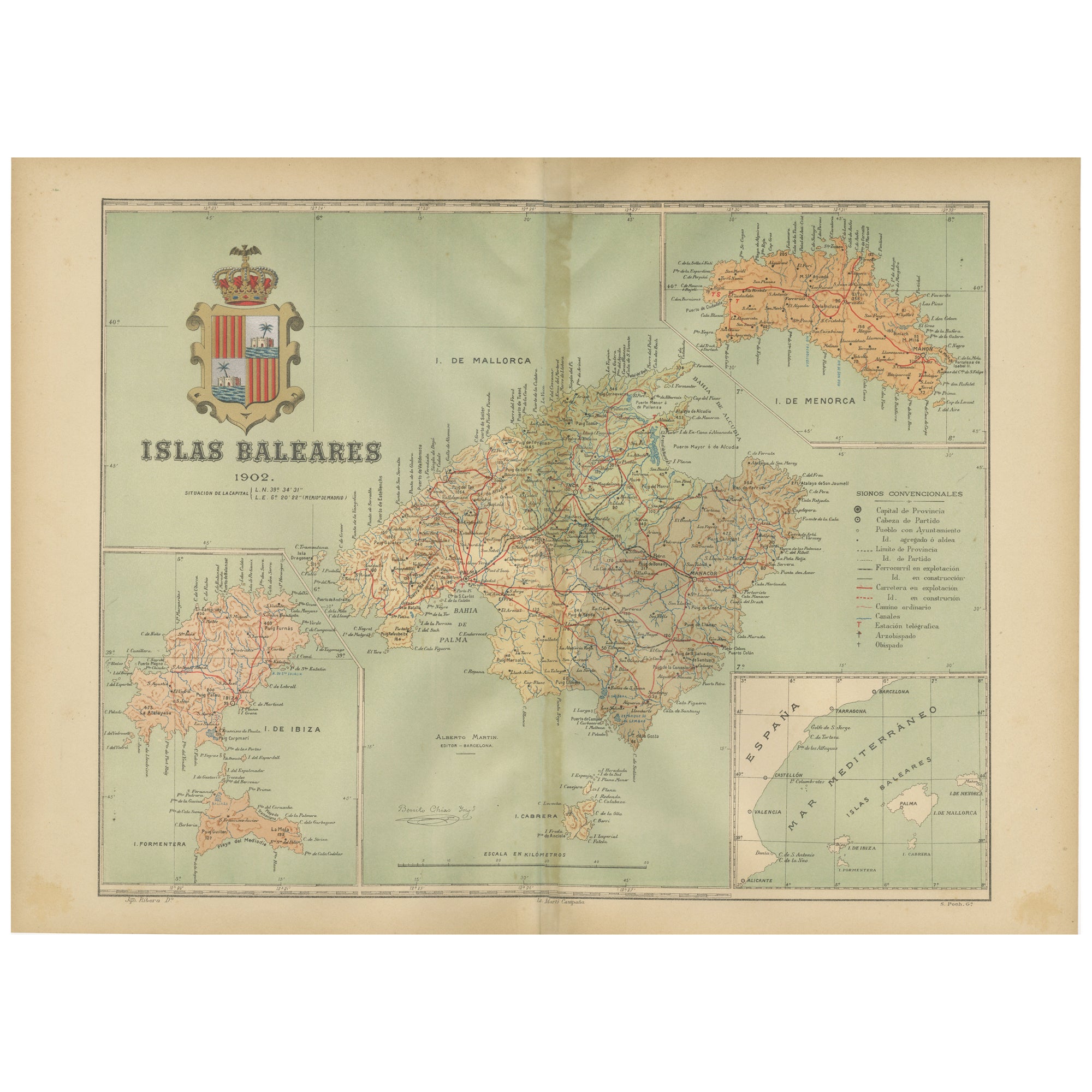
Isles of Enchantment: The Balearic Archipelago in 1902
Located in Langweer, NL
The Balearic Islands, Spain, from the year 1902. The title on the map is "ISLAS BALEARES 1902." This map illustrates the Balearic archipelago in the Mediterranean Sea, highlighting t...
Category
Antique Early 1900s Maps
Materials
Paper
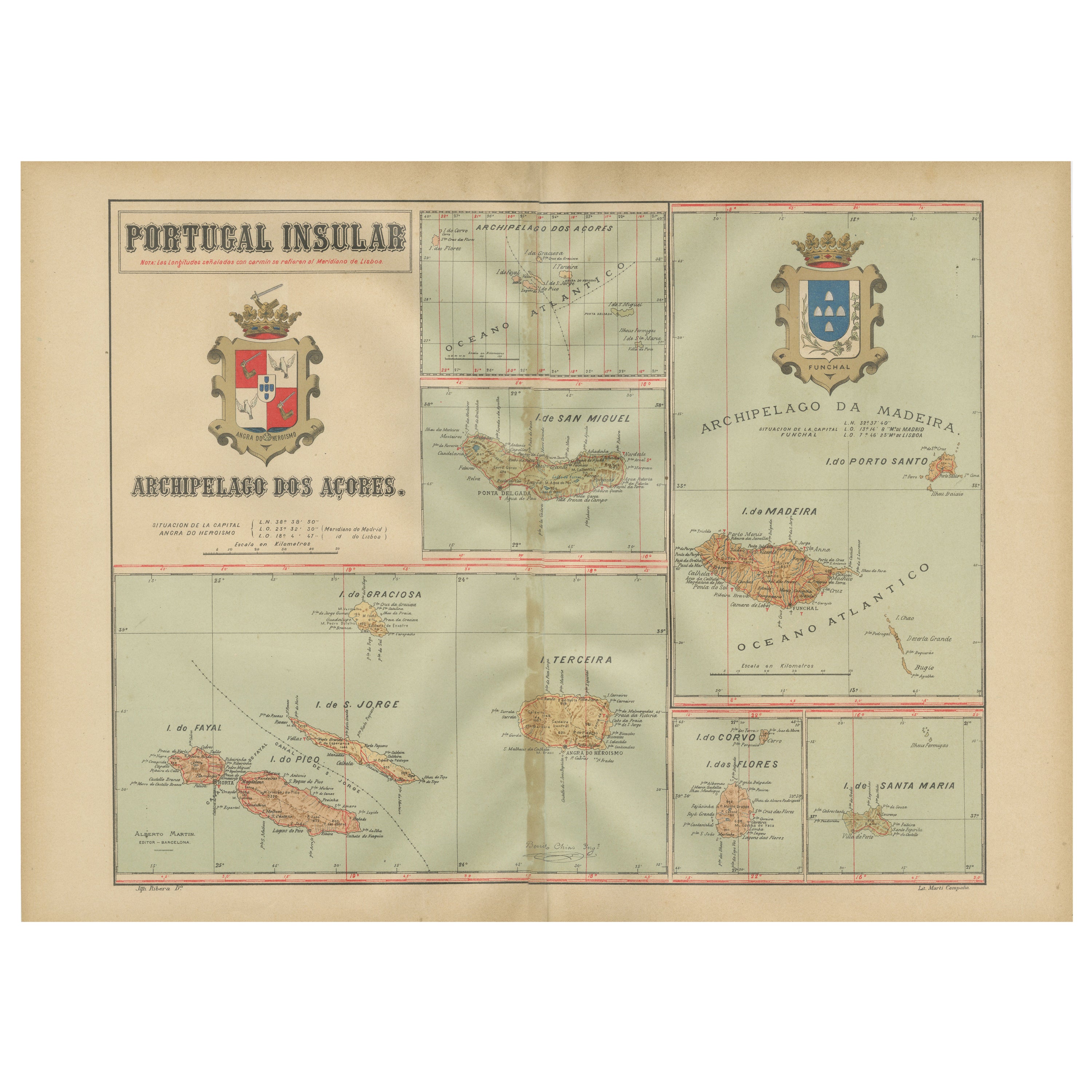
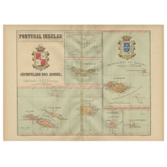
Atlantic Eden: The Azores and Madeira Archipelagos in 1903
Located in Langweer, NL
This original antique print is a historical map titled "PORTUGAL INSULAR," which translates to "Insular Portugal." It shows the Portuguese archipelagos of the Azores and Madeira, wit...
Category
Antique Early 1900s Maps
Materials
Paper
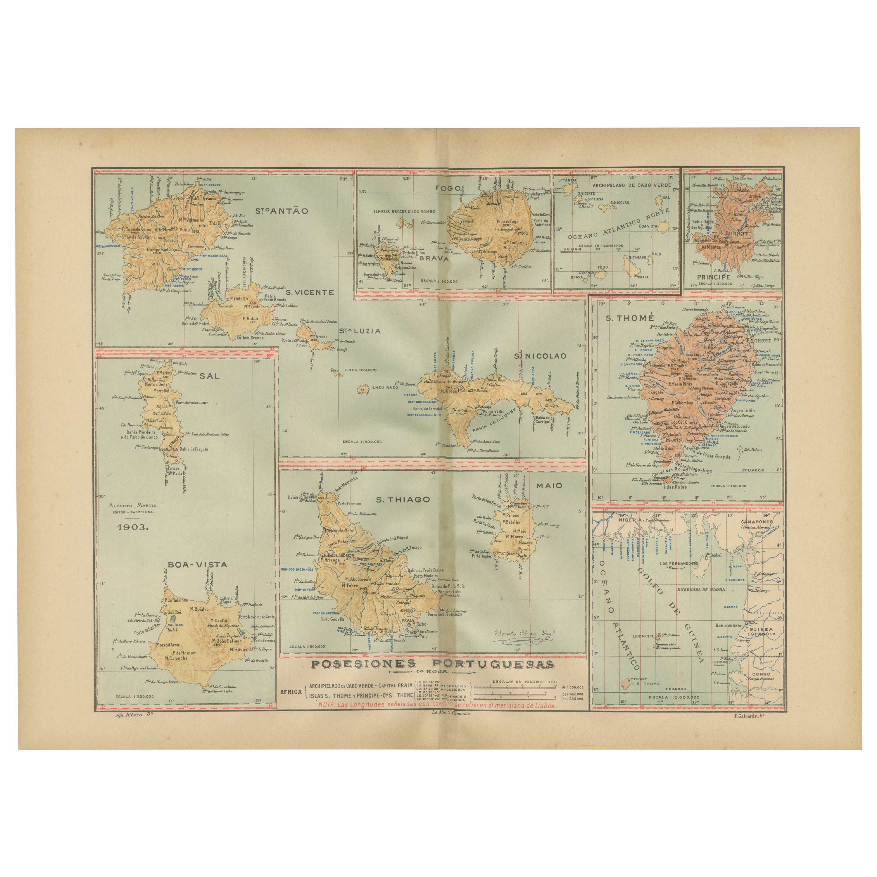
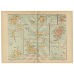
Islands of Diversity: Portugal's Atlantic Archipelagos in 1903
Located in Langweer, NL
The image is an original historical map from 1903 depicting Portuguese possessions in the Atlantic Ocean, specifically the islands of Cape Verde and the islands of São Tomé and Prínc...
Category
Antique Early 1900s Maps
Materials
Paper
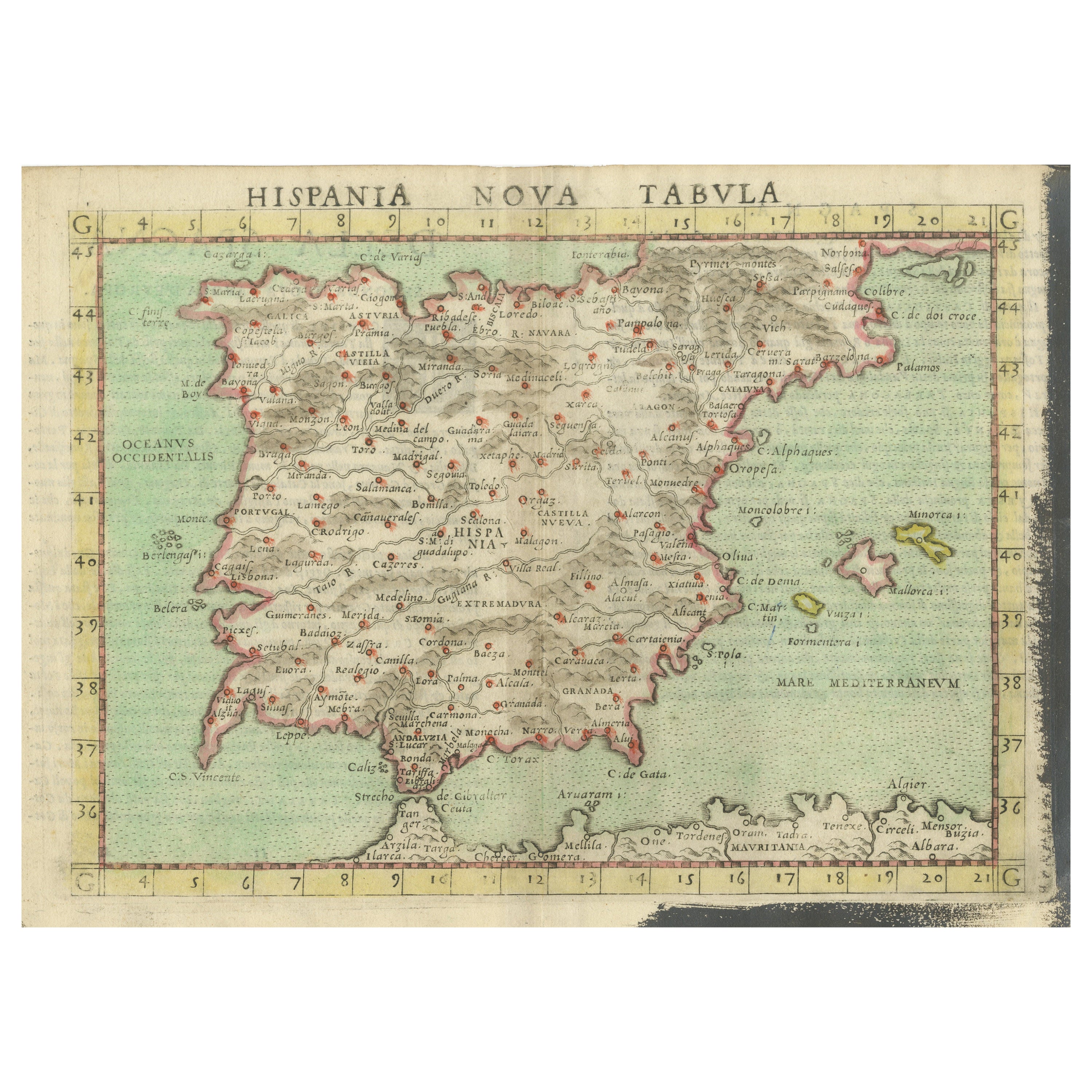
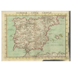
Antique Map of Spain including the Balearic Islands
Located in Langweer, NL
Antique map titled 'Hispania Nova Tabula'. Ruscelli's map of Spain, including the Balearic Islands. This map originates from 'Espositione & introduttioni universali di Gir. Ruscelli sopra tutta la Geografia di Tolomeo (..)' published by Girolamo Ruscelli, 1561.
Girolamo Ruscelli (1500-1566) was a cartographer, humanist, and scholar from Tuscany. Ruscelli was a prominent writer and editor in his time, writing about a wide variety of topics including the works of Giovanni Boccaccio and Francesco Petrarch, Italian language, Italian poetry, medicine, alchemy, and militia. One of his most notable works was a translation of Ptolemy’s Geographia...
Category
Antique 16th Century Maps
Materials
Paper
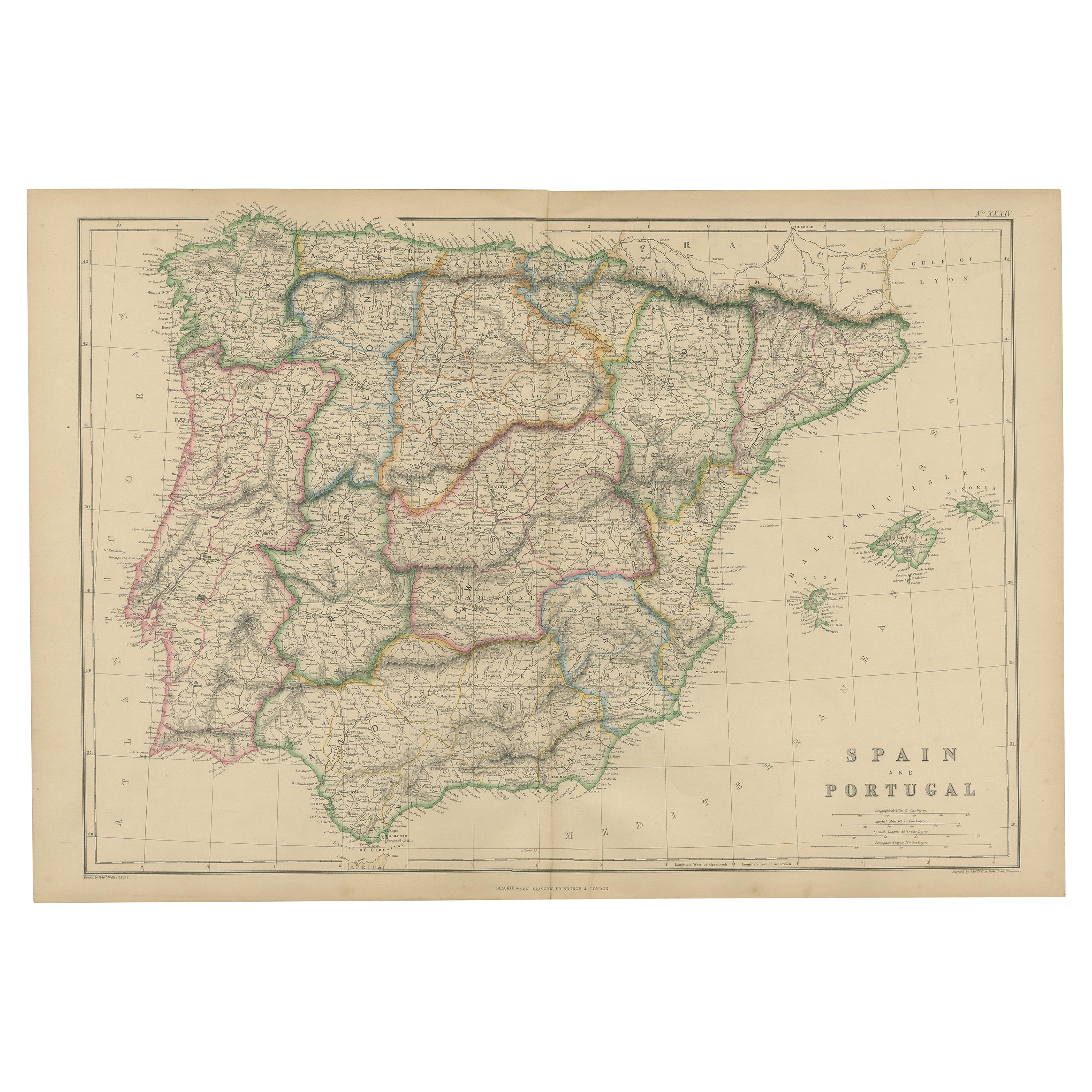
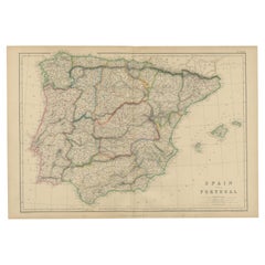
Vintage Geographic Splendor: 1859 Spain and Portugal
Located in Langweer, NL
The "Vintage Geographic Splendor: 1859 Spain and Portugal" map is an original antique piece from 'The Imperial Atlas of Modern Geography', published ...
Category
Antique Mid-19th Century Maps
Materials
Paper
$235 Sale Price
20% Off
You May Also Like
Large Original Antique Map of The Canary Islands. 1894
Located in St Annes, Lancashire
Superb Antique map of The Canary Islands
Published Edward Stanford, Charing Cross, London 1894
Original colour
Good condition
Unframed.
Free shipping
Category
Antique 1890s English Maps
Materials
Paper

Large Original Vintage Map of Spain, circa 1920
Located in St Annes, Lancashire
Great map of Spain
Original color.
Good condition
Published by Alexander Gross
Unframed.
Category
Vintage 1920s English Maps
Materials
Paper

Map Sussex
Located in BUNGAY, SUFFOLK
Map of Sussex with explanation
Maker unknown.
Category
Antique 19th Century English Victorian Maps
Materials
Paper

$812
Original Antique Map of Spain and Portugal, circa 1790
Located in St Annes, Lancashire
Super map of Spain and Portugal
Copper plate engraving by A. Bell
Published, circa 1790.
Unframed.
Category
Antique 1790s English Other Maps
Materials
Paper

Curaçao map - C. van Baarsel en zoon
Located in UTRECHT, UT
“Kaart van het eiland Curaçao.”, “Algemeene kaart der Caraïbische eilanden”, “Plan van het fort Amsterdam op Curaçao” from the atlas “Atlas der overzeesche bezittingen van Zijne Maje...
Category
Antique 1810s Dutch Other Maps
Materials
Paper
Vintage Framed Print of Spain, Canary Islands and Portugal, Framed
Located in Miami, FL
Vintage Framed Print of Spain, Canary Islands and Portugal, Framed
Offered for sale is a vintage framed print of a map of Spain, the Canary Islands, ...
Category
20th Century European Prints
Materials
Wire
More Ways To Browse
Antique Fire Collectibles
Antique Sky Map
Host Station
Early American Chairs
Hans Muller
Vintage Wood Table With Glass Top
19th Century Square Table
Antonio Bonet
Galle Chairs
Large Chinese Rug
1940s Vintage French Art Deco
20th Century Spanish Table
Antonio Bellini
Retro Fiberglass Furniture
Shipping Crate
Antique Oushak Carpets
Blue Coffee Tables
German Bauhaus Posters