Items Similar to Isles of Enchantment: The Balearic Archipelago in 1902

Want more images or videos?
Request additional images or videos from the seller
1 of 9
Isles of Enchantment: The Balearic Archipelago in 1902
About the Item
The Balearic Islands, Spain, from the year 1902. The title on the map is "ISLAS BALEARES 1902." This map illustrates the Balearic archipelago in the Mediterranean Sea, highlighting the islands of Mallorca, Menorca, Ibiza, and Formentera along with numerous smaller islets such as Cabrera.
The map features topographical contours, road networks, and maritime routes. It also includes a legend with symbols for provincial capitals, towns, roads, railroads, telegraph stations, and lighthouses. The Balearic Islands are known for their distinct cultural heritage, beautiful coastlines, and historical significance.
Special aspects of the Balearic Islands include:
1. **Diverse Landscapes**: From the mountainous terrain of the Serra de Tramuntana in Mallorca, a UNESCO World Heritage site, to the sandy beaches and coves scattered across the islands.
2. **Cultural Heritage**: The islands have a rich history, with influences from the Phoenicians, Romans, Moors, and Spanish. Each culture has left its mark on the architecture, language, and customs of the islands.
3. **Menorca's Biosphere Reserve**: Menorca was declared a UNESCO Biosphere Reserve due to its high degree of biodiversity and cultural landscapes.
4. **Ibiza's Nightlife**: Ibiza is world-renowned for its vibrant nightlife and electronic music scene, attracting DJs and party-goers from all over the globe.
5. **Traditional Crafts**: The islands are known for traditional crafts, such as shoe-making in Mallorca and basket-weaving in Menorca.
6. **Archaeological Sites**: There are numerous prehistoric megalithic sites, such as the Talayotic settlements on Menorca and the Phoenician ruins on Ibiza.
7. **Cuisine**: The Balearic cuisine is rich with Mediterranean flavors, featuring fresh seafood, local meats, fruits, and vegetables.
- Dimensions:Height: 14.77 in (37.5 cm)Width: 20.08 in (51 cm)Depth: 0 in (0.02 mm)
- Materials and Techniques:
- Period:1900-1909
- Date of Manufacture:1902
- Condition:Good condition. Central vertical folding lines as issued. Aged paper with typically warm, yellowish-brown hue, especially around the edges and folding lines, adding to its patina. Check the images carefully.
- Seller Location:Langweer, NL
- Reference Number:
About the Seller
5.0
Platinum Seller
These expertly vetted sellers are 1stDibs' most experienced sellers and are rated highest by our customers.
Established in 2009
1stDibs seller since 2017
1,929 sales on 1stDibs
Typical response time: <1 hour
- ShippingRetrieving quote...Ships From: Langweer, Netherlands
- Return PolicyA return for this item may be initiated within 14 days of delivery.
More From This SellerView All
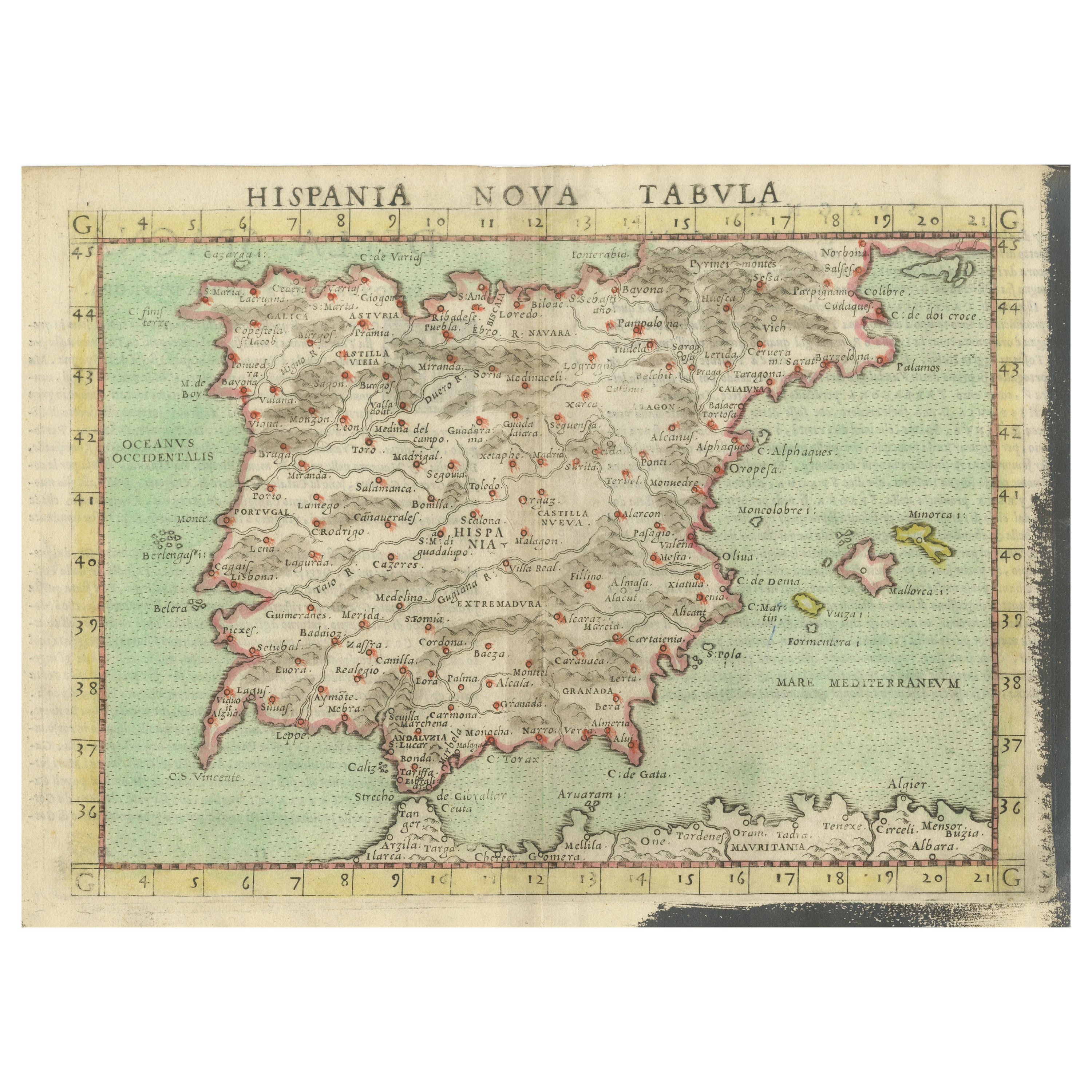
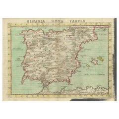
- Antique Map of Spain including the Balearic IslandsLocated in Langweer, NLAntique map titled 'Hispania Nova Tabula'. Ruscelli's map of Spain, including the Balearic Islands. This map originates from 'Espositione & introduttioni universali di Gir. Ruscelli sopra tutta la Geografia di Tolomeo (..)' published by Girolamo Ruscelli, 1561. Girolamo Ruscelli (1500-1566) was a cartographer, humanist, and scholar from Tuscany. Ruscelli was a prominent writer and editor in his time, writing about a wide variety of topics including the works of Giovanni Boccaccio and Francesco Petrarch, Italian language, Italian poetry, medicine, alchemy, and militia. One of his most notable works was a translation of Ptolemy’s Geographia...Category
Antique 16th Century Maps
MaterialsPaper
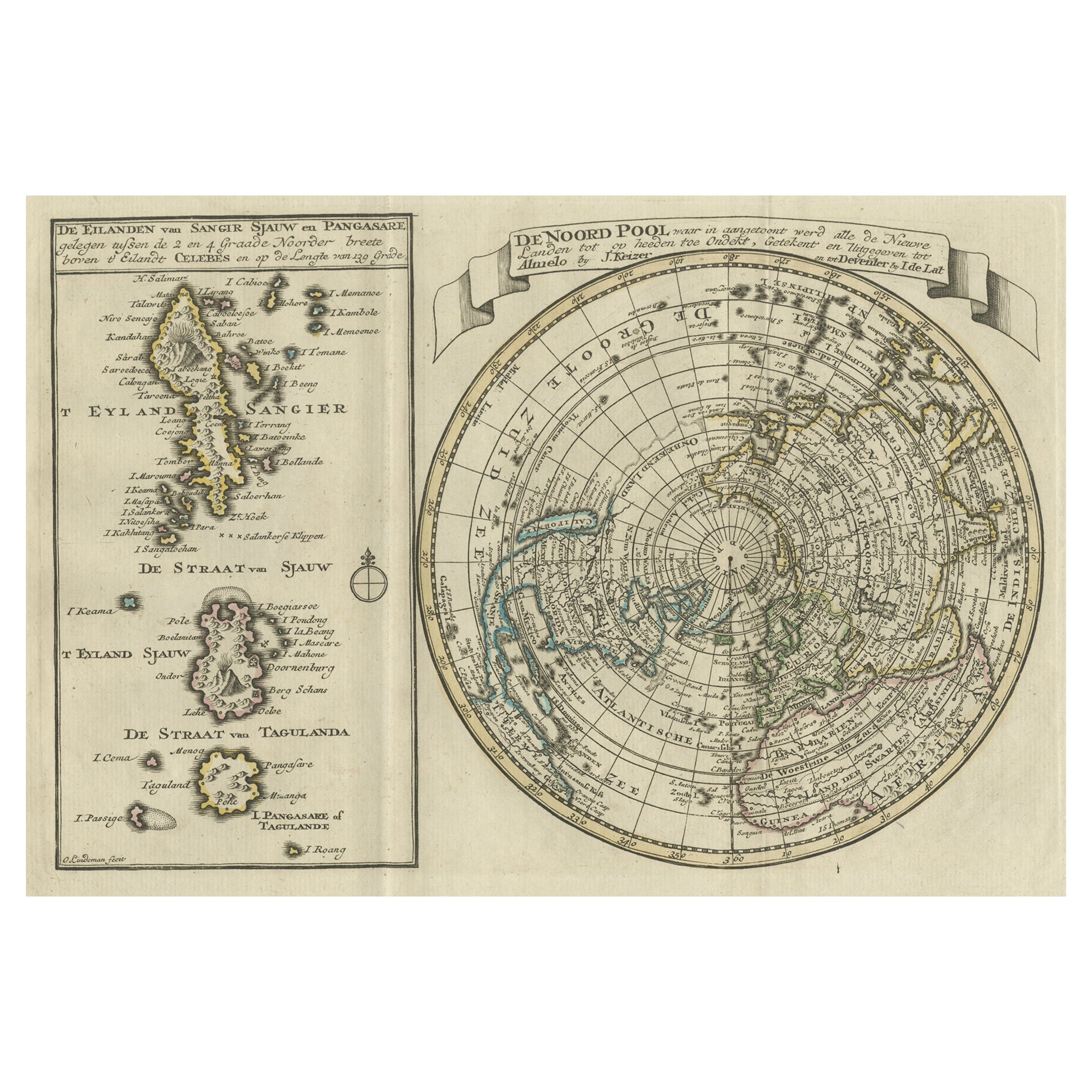
- Nice Sheet of the Sangihe Archipelago in Indonesia & California Island, 1788Located in Langweer, NLAntique map titled 'De Noord Pool waar in aangetoont werd alle de Nieuwe Landen (..) De Eilanden van Sangir Sjauw en Pangasare (..)'. Interesting map that includes a map of the N...Category
Antique 1780s Maps
MaterialsPaper
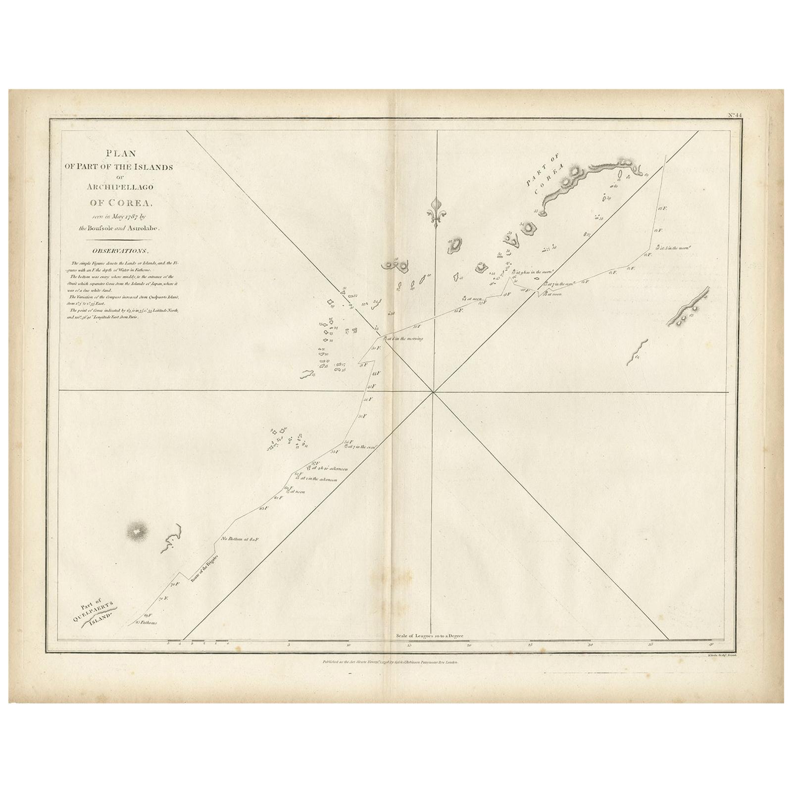
- Antique Map of Part of the Korean Archipelago, 1798Located in Langweer, NLAntique map titled 'Plan of Part of the Islands or Archipellago of Corea'. This map depicts part of the Korean Archipelago and originates from Charts and Plates to La Pérouse...Category
Antique Late 18th Century Maps
MaterialsPaper
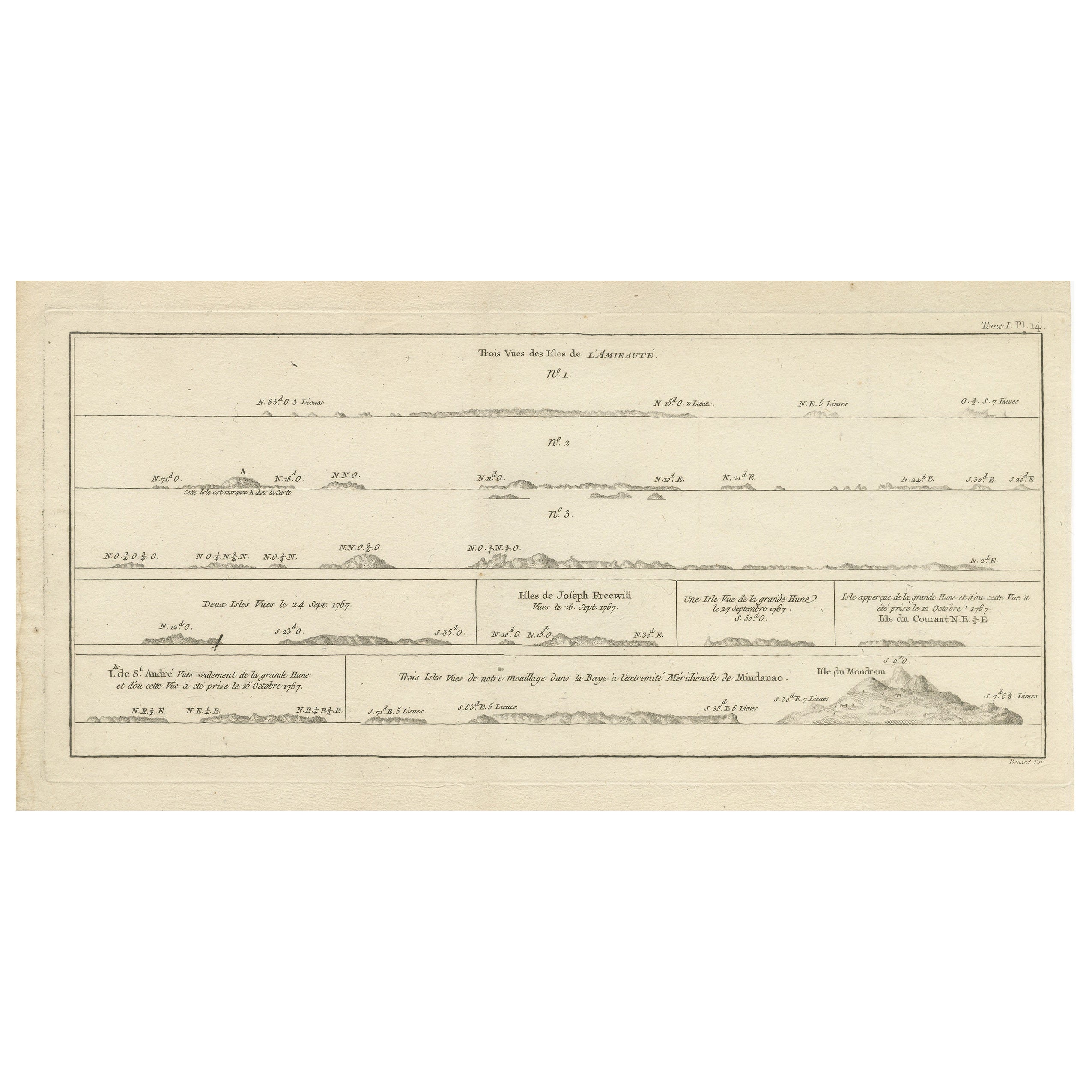
- Antique Map of the Admiralty Islands, Bismarck ArchipelagoLocated in Langweer, NLAntique map titled 'Trois Vues des Isles de l'Amirauté'. Several coastal views of the Admiralty Islands, Bismarck Archipelago, to the north of New Guinea in the South Pacific Ocean. ...Category
Antique Late 18th Century Maps
MaterialsPaper
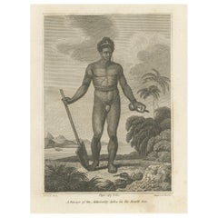
- Engraving of A Savage of the Admiralty Isles in the Bismarck Archipelago, 1801Located in Langweer, NLThe 1801 engraving depicts a figure labeled as "A Savage of the Admiralty Isles in the South Sea." The image portrays a solitary indigenous man standing with a paddle in hand, exudin...Category
Antique Early 1800s Prints
MaterialsPaper
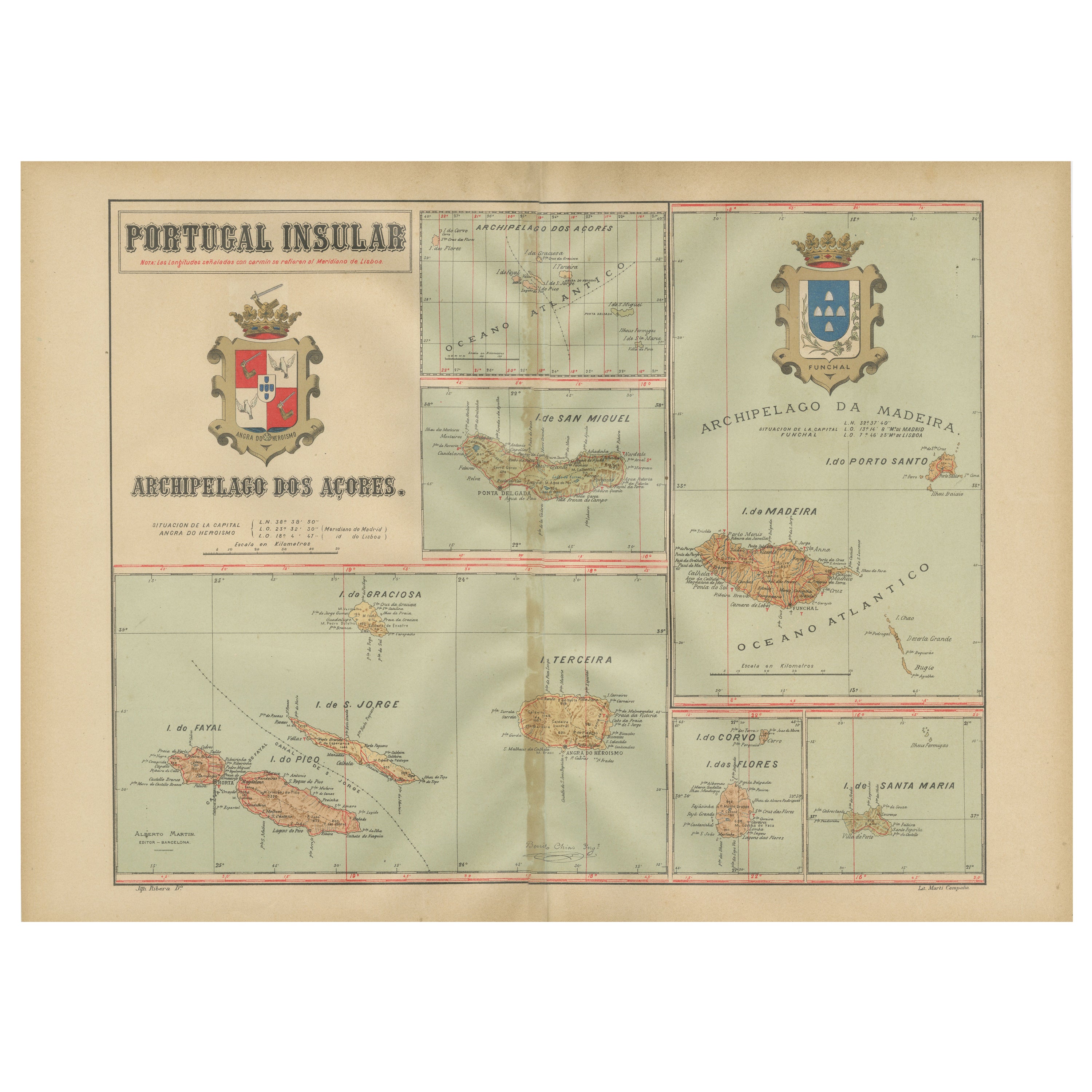
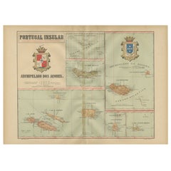
- Atlantic Eden: The Azores and Madeira Archipelagos in 1903Located in Langweer, NLThis original antique print is a historical map titled "PORTUGAL INSULAR," which translates to "Insular Portugal." It shows the Portuguese archipelagos of the Azores and Madeira, wit...Category
Antique Early 1900s Maps
MaterialsPaper

You May Also Like
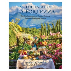
- At the Table of La Fortezza, The Enchantment of Tuscan CookingBy Rizzoli International PublicationsLocated in New York, NYAt the Table of La Fortezza: The Enchantment of Tuscan Cooking from the Lunigiana Region. Author Annette Joseph, Photographs by David Loftus. Annette Joseph shares recipes from the charming Lunigiana region of Tuscany that were developed at her medieval fortress, La Fortezza. This is the first book on the cuisine of this important slow-food area. Lunigiana is a rugged, mountainous region of Tuscany, flanked by the Liguria coastline and Emilia-Romagna, whose cuisine has been shaped by its distinctive landscape and location. Author and stylist Annette Joseph purchased and renovated a stunning medieval fortress, aptly named La Fortezza (“The Fortress”), in this little-known area. Enamored by Lunigiana’s rich food heritage and traditions, Joseph sought out authentic and traditional dishes from the best chefs, home cooks, and slow-food purveyors in the region. This book showcases these rustic recipes, some of which have been enjoyed for centuries. Lunigiana’s cuisine brings together the flavors of both the coast and the mountains and draws inspiration from the neighboring regions. It is home to unique ingredients, such as chestnut flour, and its specialties are often still prepared the ancient way. Lunigiana is also recognized by UNESCO as a sustainable region, and Joseph’s recipes highlight slow-food practices, such as sourcing seasonal ingredients from local producers. Breathtaking photographs by David Loftus highlight the beauty of Lunigiana’s cuisine and countryside, as well as La Fortezza’s dreamy vineyard, orchards, and kitchen garden. This book is an incredible culinary and visual journey into an undiscovered region in Italy and a must-have for anyone who loves Italian food...Category
21st Century and Contemporary Books
MaterialsPaper
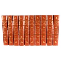
- 1902 The Complete Works of Edgar Allan PoeLocated in Bath, GBA beautiful limited edition set of the complete works of Edgar Allan Poe, illustrated with ten plates to each volume, and signed by the publisher. The Arnheim Edition of Poe's works...Category
Antique Early 1900s Books
MaterialsPaper
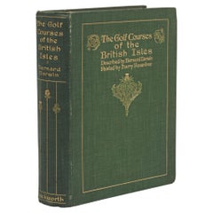
- Golf Book, Bernhard Darwin, Golf Courses of the British IslesLocated in Oxfordshire, GBAntique Golf Book, The Golf Courses of the British Isles Described by Bernard Darwin. A fantastic first edition golf book written by Bernard Darwin, one of the greatest golf writers ever to put pen to paper. 'THE GOLF COURSES OF THE BRITISH ISLES, DESCRIBED BY BERNARD DARWIN, PAINTED BY HARRY ROUNTREE...Category
Vintage 1910s British Sporting Art Books
MaterialsPaper
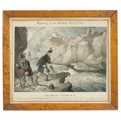
- Fishing Picture, Sporting in the Scottish Isles, Salmon Fishing, William HeathBy William Heath WilsonLocated in Oxfordshire, GBSalmon fishing lithograph by William Heath. An early rare hand coloured salmon fishing lithograph by William Heath, originally done as a set of four. This singular picture is entitled 'Sporting In The Scottish Isles' with secondary title 'Salmon Fishing', 'Drawn on stone by William Heath, from sketches taken by him in the Islands of Islay'. Framed in maple frame with glass. Published April 21st 1835 by Rudolph Ackermann. The other three pictures in the set are Grouse Shooting...Category
Antique 1830s British Sporting Art Sports Equipment and Memorabilia
MaterialsPaper
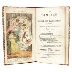
- PLANCHE - The Vampire; or Bride of the isles - 1820 - FIRST AND ONLY EDITIONLocated in Hillsborough, NJAUTHOR: PLANCHE, James Robinson: Pierre-Frederic-Adolphe Carmouche. TITLE: The Vampire; or, Bride of the isles, A Tale, founded on the popular superstition of Caledonia.... From wh...Category
Antique 1820s British Books
MaterialsLeather
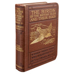
- Antique Book, Birds Of The British Isles, English, Ornithology Reference, C.1920Located in Hele, Devon, GBThis is an antique illustrated book of The Birds of the British Isles. An English, bound ornithology reference title, dating to the early 20th century, published 1920. Full Title - ...Category
Early 20th Century European Mid-Century Modern Books
MaterialsLeather, Paper
Recently Viewed
View AllMore Ways To Browse
Map Of Old Armenia
Teak Wood Sphere
Nova Guinea Maps
Antique Map Of Illinois
Petite Point Hand Bag
Antique Map Of Southeastern Us
Antique Map Alabama
Antique Map Of Sydney
Malay Archipelago Map
Gambia Antique Map
Uruguay Antique Map
Guyana Antique Map
Ruscelli Map
Masque Theatre No
Nova Scotia Map
Antique Map Tuscany
Berkshire Antique Map
Cornwall Map