Items Similar to Nice Sheet of the Sangihe Archipelago in Indonesia & California Island, 1788

Want more images or videos?
Request additional images or videos from the seller
1 of 5
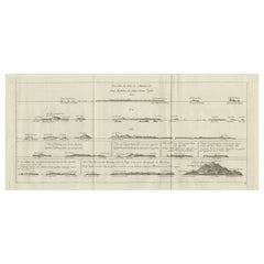
Nice Sheet of the Sangihe Archipelago in Indonesia & California Island, 1788
About the Item
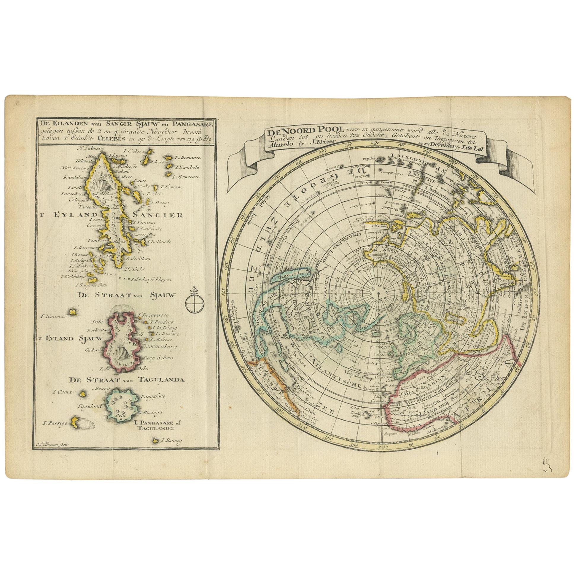
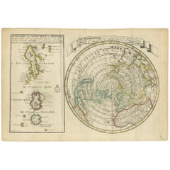
Antique map titled 'De Noord Pool waar in aangetoont werd alle de Nieuwe Landen (..)
De Eilanden van Sangir Sjauw en Pangasare (..)'. Interesting map that includes a map of the North Pole featuring the island of California with a narrow isthmus near the center of its eastern coast, and a faint coastline labeled, Onbekend Land, nearly connecting Asia and North America. A second map that takes up nearly a third of the sheet covers the volcanic islands of the Sangihe Archipelago in Indonesia. This map originates from 'Nieuwe Natuur- Geschied- en Handelkundige Zak- en Reisatlas' by Gerrit Brender à Brandis.
Artists and Engravers: Published by J. Keizer and I. de Lat, 1788.
- Dimensions:Height: 8.08 in (20.5 cm)Width: 12.01 in (30.5 cm)Depth: 0 in (0.02 mm)
- Materials and Techniques:
- Period:1780-1789
- Date of Manufacture:1788
- Condition:Condition: General age-related toning. Original folding lines. Original/contemporary hand coloring, blank verso. Minor wear, please study image carefully.
- Seller Location:Langweer, NL
- Reference Number:
About the Seller
5.0
Platinum Seller
These expertly vetted sellers are 1stDibs' most experienced sellers and are rated highest by our customers.
Established in 2009
1stDibs seller since 2017
1,938 sales on 1stDibs
Typical response time: <1 hour
- ShippingRetrieving quote...Ships From: Langweer, Netherlands
- Return PolicyA return for this item may be initiated within 14 days of delivery.
More From This SellerView All
- Antique Map of the North Pole & Sangihe Archipelago by Keizer & de Lat, 1788Located in Langweer, NLAntique map titled 'De Noord Pool waar in aangetoont werd alle de Nieuwe Landen (..) - De Eilanden van Sangir Sjauw en Pangasare (..)'. Interesting map that includes a map of the Nor...Category
Antique Late 18th Century Maps
MaterialsPaper
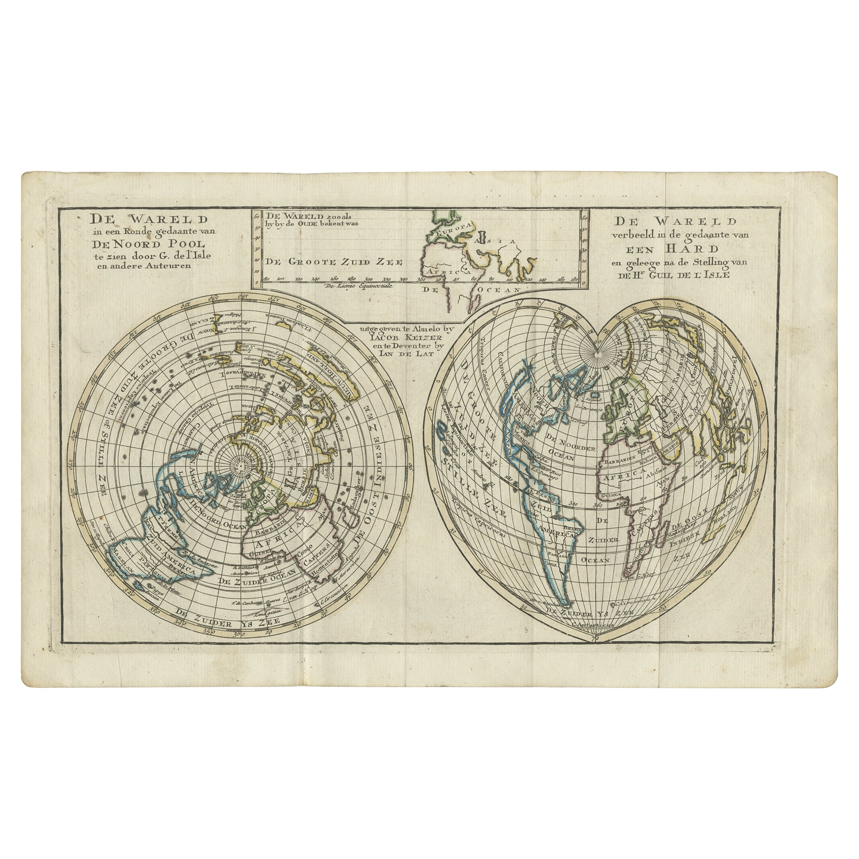
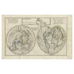
- Antique Map of the World with California as an Island, 1788Located in Langweer, NLDescription: Antique map titled 'De wareld in een ronde gedaante van de Noord Pool te zien - De Wareld verbeeld in de gedaante van een hard'. This interesting composition contains three world maps on the sheet. At left is a northern projection showing all the landmasses. At right is a cordiform projection (heart-shaped). At top is a map of the world as known to the ancients. Both the polar and cordiform projections show California as an island...Category
Antique 1780s Maps
MaterialsPaper
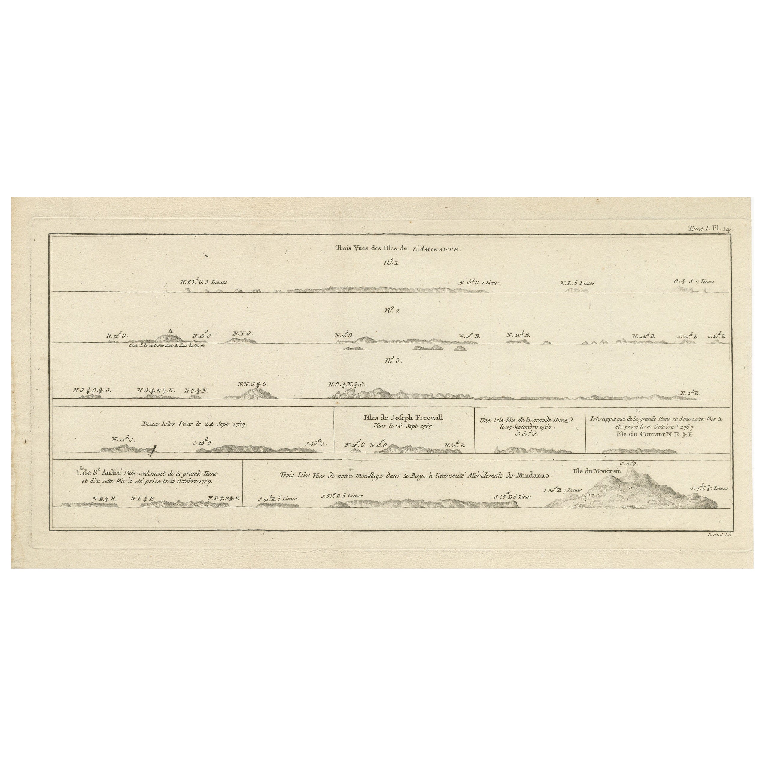
- Antique Map of the Admiralty Islands, Bismarck ArchipelagoLocated in Langweer, NLAntique map titled 'Trois Vues des Isles de l'Amirauté'. Several coastal views of the Admiralty Islands, Bismarck Archipelago, to the north of New Guinea in the South Pacific Ocean. ...Category
Antique Late 18th Century Maps
MaterialsPaper
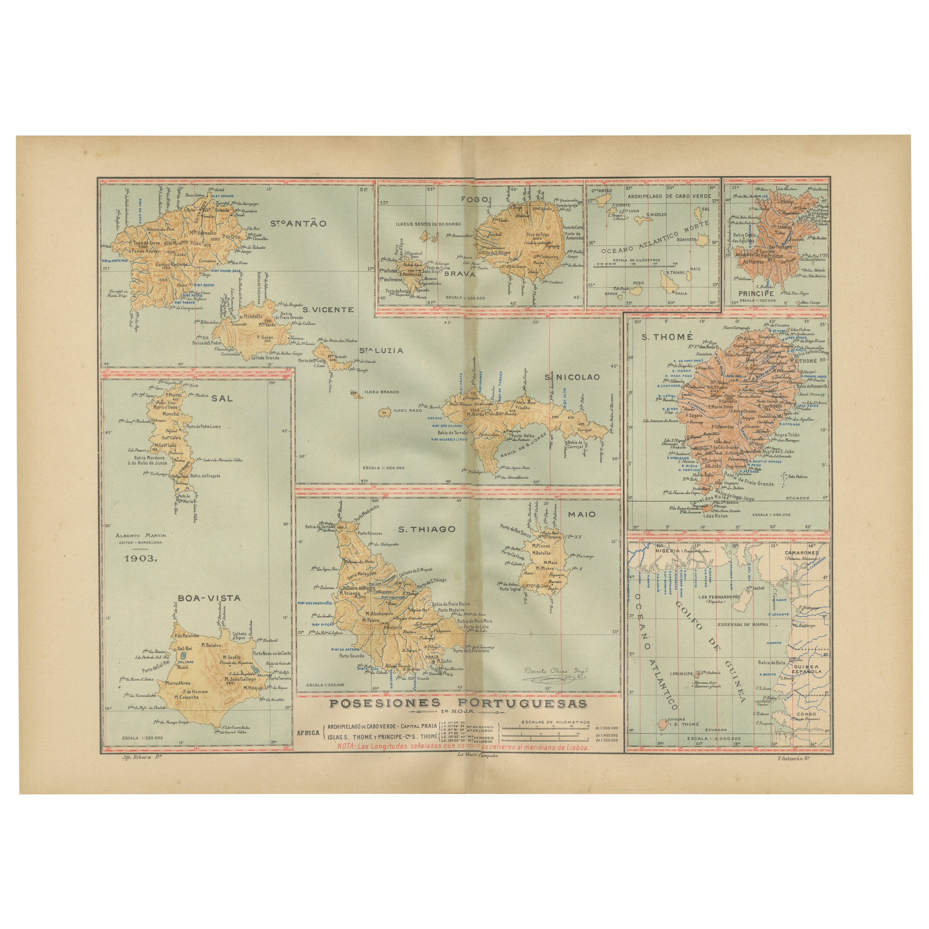
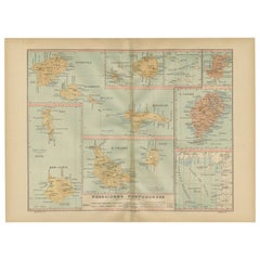
- Islands of Diversity: Portugal's Atlantic Archipelagos in 1903Located in Langweer, NLThe image is an original historical map from 1903 depicting Portuguese possessions in the Atlantic Ocean, specifically the islands of Cape Verde and the islands of São Tomé and Prínc...Category
Antique Early 1900s Maps
MaterialsPaper
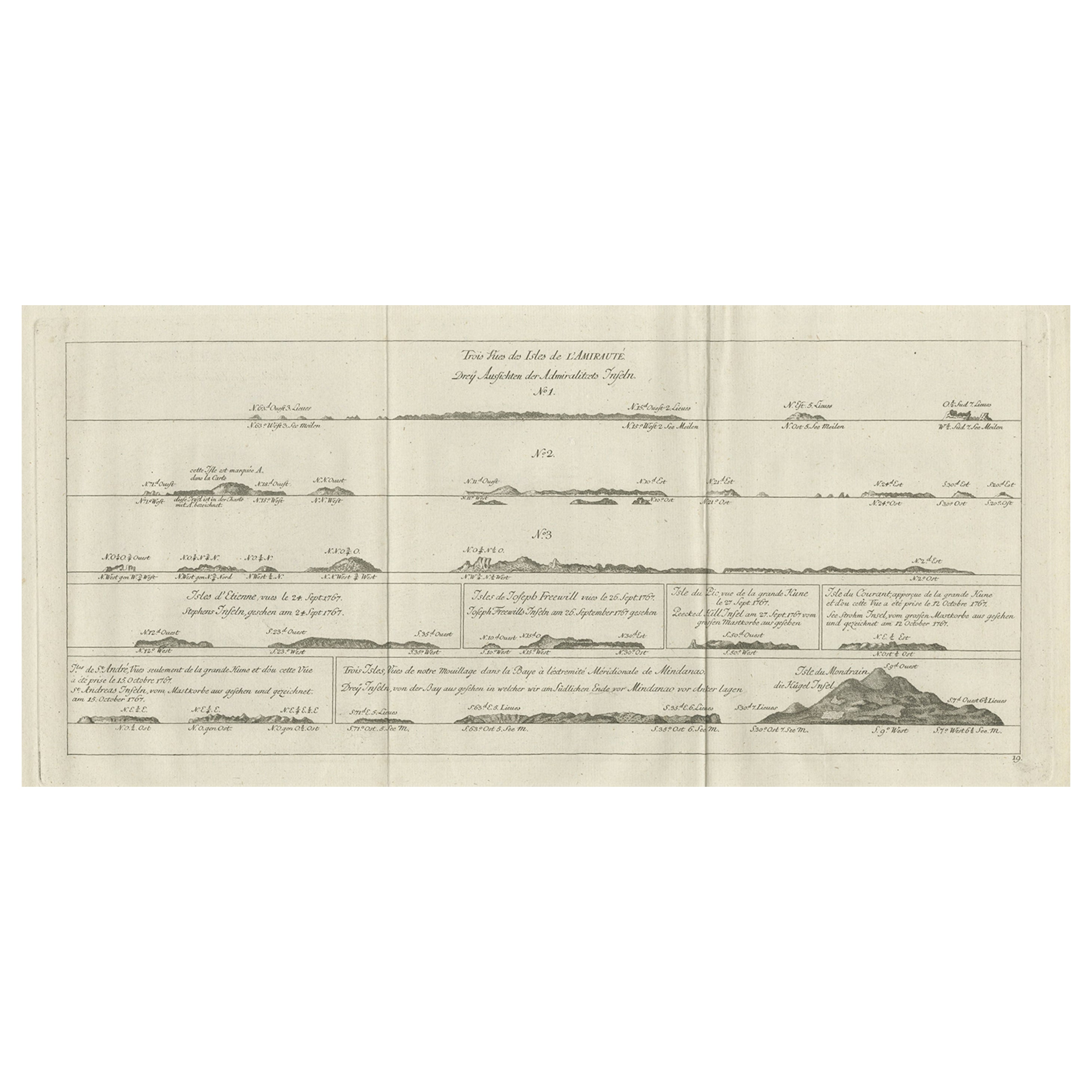
- Original Antique Engraving of the Admiralty Islands 'Bismarck Archipelago', 1774Located in Langweer, NLAntique print titled 'Trois Vues des Isles de l'Amirauté (..)'. Several coastal views of the Admiralty Islands. Originates from 'Geschichte der See-Reisen und Entdeckungen im Süd-Mee...Category
Antique 18th Century Prints
MaterialsPaper
- Antique Map of the Indonesian and Philippine Archipelagos by R. de VaugondyLocated in Langweer, NLStriking and highly detailed map of the region from Sumatra and Malaca and Southern China to the Philipines, New Guinea and Northern Australia, centered on Borneo. Includes a large i...Category
Antique Mid-18th Century Maps
MaterialsPaper


You May Also Like
- The Indonesian TableLocated in New York City, NY‘It is truly remarkable for a talented chef to also be a sensational storyteller … Petty takes you on a journey across the archipelago, through her food and her life.’ – Julien Royer...Category
21st Century and Contemporary Chinese Books
MaterialsPaper
- Proof: Photography in the Era of the Contact Sheet, Collection of Mark SchwartzLocated in valatie, NYProof: Photography in the Era of the Contact Sheet from the Collection of Mark Schwartz + Bettina Katz by Peter Galassi. Cleveland Museum of Art. A glimpse inside the darkroom--and i...Category
21st Century and Contemporary Books
MaterialsPaper
- 1865 Chart of the Islands of MadeiraLocated in Norwell, MARare James Imray chart from 1865 titled "Chart of the Islands of Madeira, Porto Santo and Dezerea" drawn from the survey made by Captain Ate Vidal Royal Navy, London. Published by Ja...Category
Antique 1860s European Maps
MaterialsPaper
- Inventing the California LookBy Rizzoli International PublicationsLocated in New York, NYInventing the California Look: Interiors by Frances Elkins, Michael Taylor, John Dickinson, and Other Design Innovators Author Philip E. Meza, Photographs by Fred Lyon, Foreword b...Category
21st Century and Contemporary Books
MaterialsPaper
- Samuel Johnson — A Journey to the Western Islands of ScotlandLocated in Middletown, NYLondon: W. Strahan and T. Cadwell, 1775. FIRST EDITION, FIRST STATE 8vo, 8 3/8 x 5 1/4 (212 x 132 mm); Title, 284 pp, 1 leaf (errata with 11 items on 12 lines). Printed on laid pap...Category
Antique Late 18th Century English Books
MaterialsLeather, Paper
- 1868 Map of the Upper Part of the Island of Manhattan Above 86th StreetBy Wm. Rogers Mfg. Co.Located in San Francisco, CAThis wonderful piece of New York City history is over 150 years old. It depicts 86th street and above. It was lithographed by WC Rogers and company. It was made to show what was the Battle of Harlem during the Revolutionary war...Category
Antique 1860s American American Colonial Maps
MaterialsPaper


Recently Viewed
View AllMore Ways To Browse
Antique Furniture California
Center Island
Antique Center Islands
North Pole
California Map
Map Of California
Antique Maps North America
Antique Map North America
Antique North America Map
North America Antique Map
Antique Maps Of North America
Antique Map Of North America
Antique Maps Indonesia
Near Eastern Antique
Antique Maps California
Antique Map California
Antique Maps Of California
Antique Map Of California