Items Similar to Northern Schleswig and Haderslev Map by Johannes Mejer and Johannes Blaeu, 1662


Want more images or videos?
Request additional images or videos from the seller
1 of 6
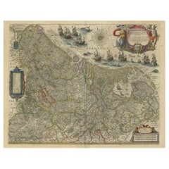
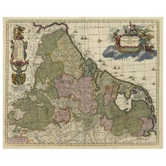
Northern Schleswig and Haderslev Map by Johannes Mejer and Johannes Blaeu, 1662
$537.57
$671.9620% Off
£396.44
£495.5520% Off
€448
€56020% Off
CA$742.38
CA$927.9720% Off
A$814.57
A$1,018.2120% Off
CHF 426.31
CHF 532.8820% Off
MX$10,024.56
MX$12,530.7120% Off
NOK 5,370.82
NOK 6,713.5320% Off
SEK 5,030.58
SEK 6,288.2220% Off
DKK 3,412.07
DKK 4,265.0920% Off
About the Item
The map shows the Duchy of Schleswig, which spans the area between the North Sea coast, Kolding, and Flensburg. The maps were originally published by Johannes Mejer in the regional atlas of Schleswig-Holstein, compiled by Caspar Danckwerth. Later, these maps were included in a revised edition by Joan Blaeu, one of the leading Dutch cartographers of the 17th century. This collaboration brought the maps to a wider European audience.
The translated Latin text within the cartouche reads as follows:
"Northern part of the Duchy of Schleswig
Dedicated to the Most Serene and Most Exalted Prince and Lord,
Lord Christian VI,
King of Denmark, Norway, the Vandals, and the Goths,
Elected Prince, Duke of Schleswig, Holstein, Stormarn, and Dithmarschen,
Count of Oldenburg and Delmenhorst, my most gracious Lord,
To whom this geographic presentation is humbly offered by its author,
Johannes Mejerus, a native of Husum (Cimbricus)."
This cartouche serves as a dedication to King Christian VI of Denmark and Norway, honoring him with his full royal titles and presenting the map as a humble offering by Johannes Mejerus, who created this map.
This map is a beautifully detailed 17th-century representation of the northern parts of the Duchy of Schleswig and eastern parts of the Haderslev region, created by Johannes Mejer and published by the famous Dutch cartographer Johannes Blaeu in Amsterdam in 1662. The map is part of a larger collection of regional maps, known for its artistic and cartographic excellence, typical of the golden age of Dutch map-making.
Key Features of the Map:
1. Geographical Coverage:
- The map covers the eastern part of Haderslev, stretching from Kolding to the coastal areas around Haderslev, and the northern part of Schleswig. It includes regions along the North Sea coast, spanning from Kolding to Flensburg, showing important towns, cities, rivers, and key features of the landscape.
- The Baltic Sea is marked as the "Baltici Pars" on the eastern side of the map, and "De Oostersee" (Eastern Sea) appears near the sea coast. Coastal features and some islands, like Romø (Röm) and Sylt (Sild), are also visible.
2. Historical and Political Context:
- Schleswig and Holstein were duchies located in the region now known as Schleswig-Holstein, a region historically contested by Denmark and Germany.
- The map shows administrative divisions (e.g., "Herde") and place names relevant to the time period, such as cities like Flensburg, Tondern (Tønder), and Schleswig. It reflects a high level of detail in both geography and the political borders of the time.
3. Decorative Elements:
- Cartouches: The map has several decorative cartouches, ornate frames typically used to enclose titles or legends. The main cartouche, located at the top center, contains a dedication to King Christian VI of Denmark, including his royal titles. The rich ornamentation and scrollwork surrounding it are typical of the baroque style of the era.
- Maritime Embellishments: Ships and possibly sea creatures are depicted in the maritime areas, reflecting both the artistic style and the significance of the region’s coastal trade routes.
- Compass Rose: Near the cartouche, there is a decorative compass rose, aiding in the orientation of the map, a common feature in navigation maps of the time.
4. Topographical Details:
- The map includes extensive topographical features, such as rivers, forests, hills, and fields, marked with great detail. Small illustrations of settlements, fortifications, and churches are also scattered throughout the landscape.
- Towns and villages are labeled with varying text sizes to indicate their relative importance. The North Sea and the Baltic Sea coasts are drawn with waves and show important sea routes and coastal features.
5. Scale and Orientation:
- The map includes a latitude scale at the top, indicating the degree lines for navigation and positioning.
- It is oriented with north at the top, a standard convention in European maps during this period.
Artistic and Historical Importance:
This map not only serves as a practical geographical reference but also as a work of art. Created by Johannes Mejer, a prominent German cartographer, and published by Blaeu, one of the most esteemed mapmakers in history, it exemplifies the cartographic and artistic achievements of the 17th century. The decorative features, such as the cartouches and maritime illustrations, elevate it beyond a mere functional map to a collectible piece reflecting the political and cultural context of its time.
This map would have been part of a larger atlas, potentially used by scholars, nobility, or wealthy merchants, providing insight into the political divisions and geography of Northern Europe during the mid-17th century.
- Dimensions:Height: 17.13 in (43.5 cm)Width: 24.57 in (62.4 cm)Depth: 0 in (0.02 mm)
- Materials and Techniques:Paper,Engraved
- Period:1660-1669
- Date of Manufacture:1662
- Condition:Additions or alterations made to the original: The left and right borders have been professionally extended or replaced. Condition: good, given age. Light foxing, soilng and creasing. General age-related toning and/or occasional minor defects from handling. Left and right borders have been restored. Folding line as issued. Please study scan carefully.
- Seller Location:Langweer, NL
- Reference Number:Seller: BG-13672-51stDibs: LU3054341505532
About the Seller
5.0
Recognized Seller
These prestigious sellers are industry leaders and represent the highest echelon for item quality and design.
Platinum Seller
Premium sellers with a 4.7+ rating and 24-hour response times
Established in 2009
1stDibs seller since 2017
2,618 sales on 1stDibs
Typical response time: <1 hour
- ShippingRetrieving quote...Shipping from: Langweer, Netherlands
- Return Policy
Authenticity Guarantee
In the unlikely event there’s an issue with an item’s authenticity, contact us within 1 year for a full refund. DetailsMoney-Back Guarantee
If your item is not as described, is damaged in transit, or does not arrive, contact us within 7 days for a full refund. Details24-Hour Cancellation
You have a 24-hour grace period in which to reconsider your purchase, with no questions asked.Vetted Professional Sellers
Our world-class sellers must adhere to strict standards for service and quality, maintaining the integrity of our listings.Price-Match Guarantee
If you find that a seller listed the same item for a lower price elsewhere, we’ll match it.Trusted Global Delivery
Our best-in-class carrier network provides specialized shipping options worldwide, including custom delivery.More From This Seller
View AllEarly Antique Map of Gelderland and Overijssel in the Netherlands, c.1625
Located in Langweer, NL
Antique map titled 'Geldria et Transysulana'.
One of the earliest maps of Gelderland and Overijssel in the Netherlands, prepared by Gerard Mercator.
Artists and Engravers: Gerard...
Category
Antique 17th Century Maps
Materials
Paper

$623 Sale Price
20% Off
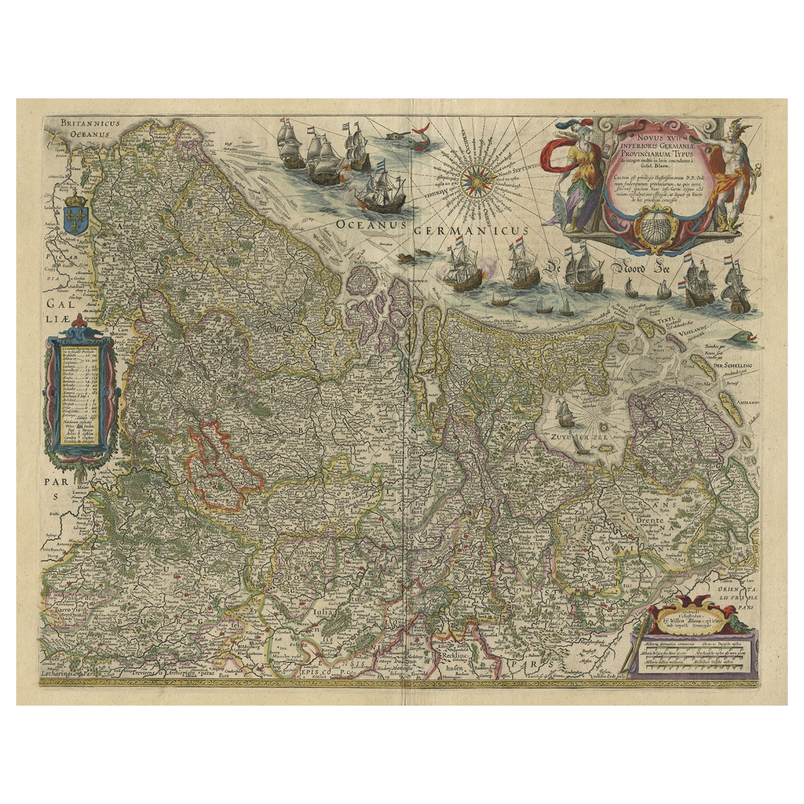
Handsome Old Detailed Map of the Low Countries by Famous Mapmaker Blaeu, ca.1635
Located in Langweer, NL
Antique map titled 'Novus XVII Inferioris Germaniae Provinciarum Typus'.
Handsome - and much sought after- detailed map of the Low Countries by the world most famous map maker Bla...
Category
Antique 1630s Maps
Materials
Paper
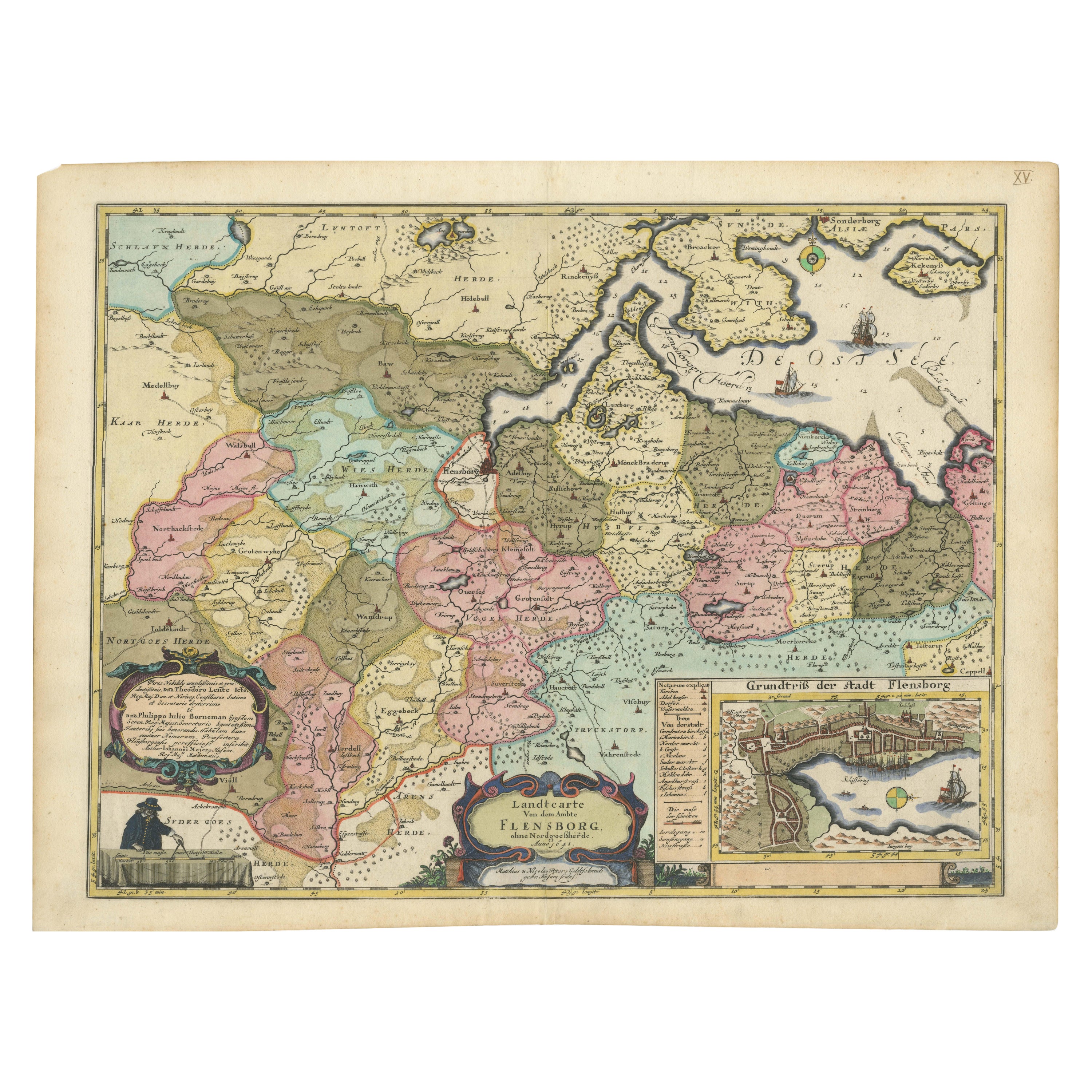
Cartographic Depiction of Flensburg and Surrounding Territories, Anno 1648
Located in Langweer, NL
Title: Landtcarte Vonn dem Ambte Flensborg, ohne Nordgoeßherde. Anno 1648.
Description:
This exquisitely detailed and old coloured map of Flensburg was crafted by the noted cartogr...
Category
Antique 1640s German Maps
Materials
Paper

$1,190 Sale Price
20% Off
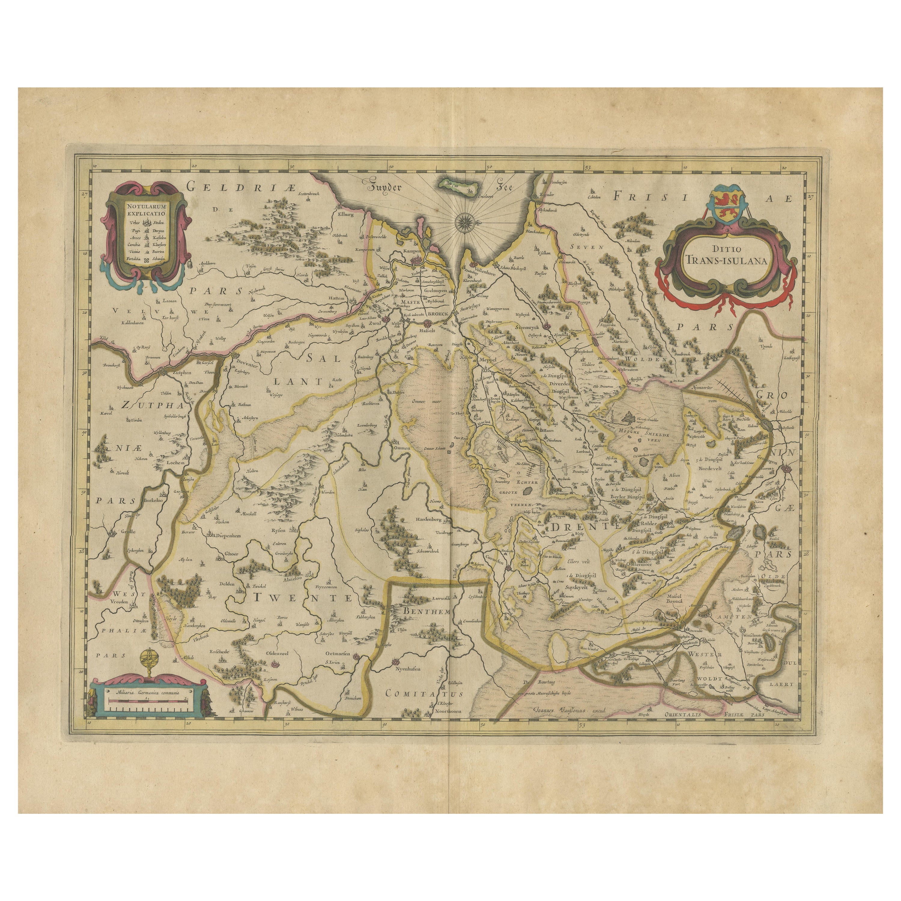
Original Antique Map of the Dutch Provinces of Overijssel and Drenthe, 1635
Located in Langweer, NL
Antique map titled 'Transiselania Dominium vernacule Over-Yssel.' - Map of the Dutch Provinces of Overijssel and Drenthe. Dedicated to Mr. Bartold Wich...
Category
Antique 1630s Maps
Materials
Paper

$460 Sale Price
20% Off
Antique Map by Janssonius of the Dutch Province of Overijsel, ca.1650
Located in Langweer, NL
Very good, given the age. Center fold as issued with wide margins. Sharp print with beautiful old-fashioned colouring, carbon copy on verso. Paper in the margins somewhat browned.
Category
Antique 1650s Maps
Materials
Paper

$422 Sale Price
20% Off
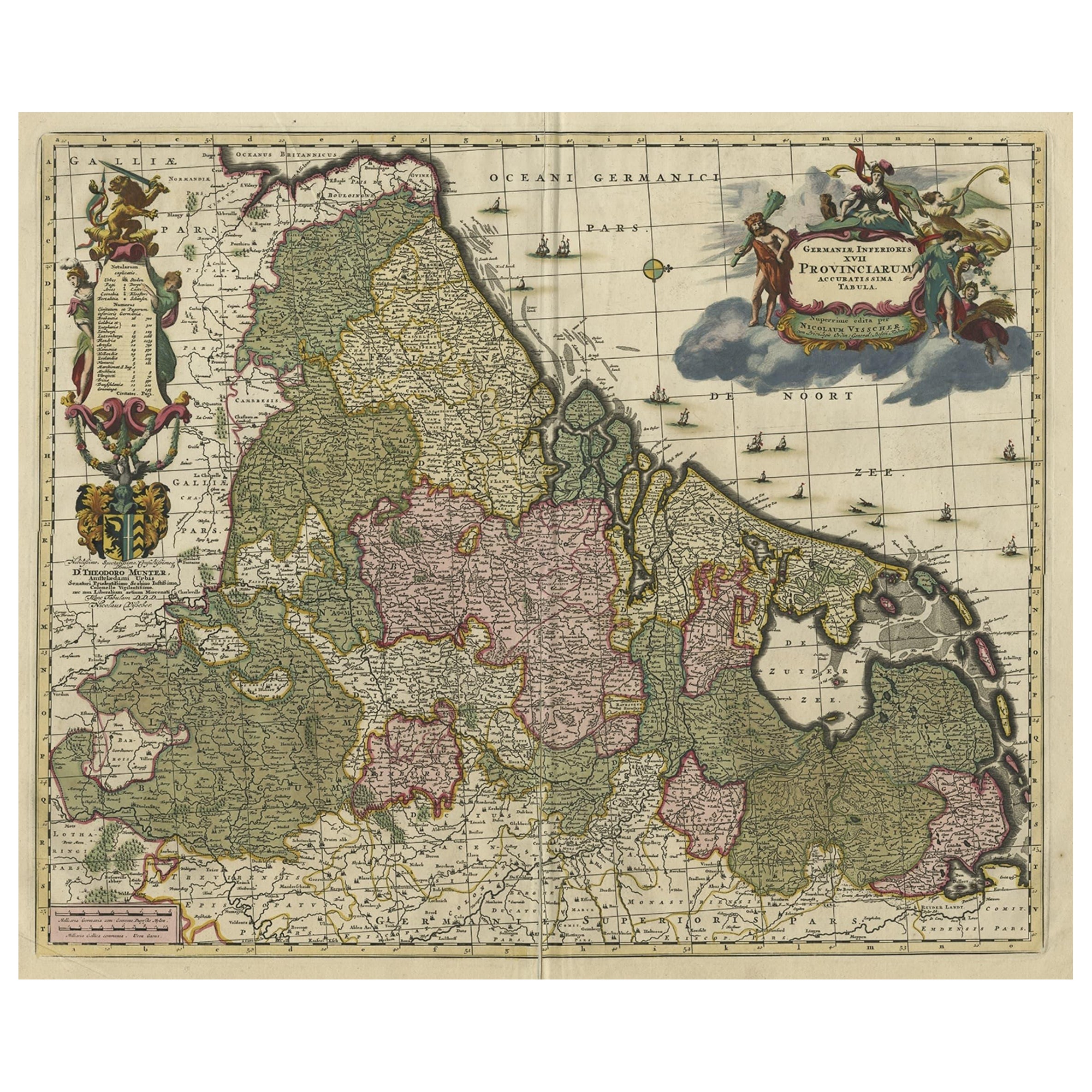
Antique Decorative Map of the Low Countries, '17 Provinces, Netherlands', c.1680
Located in Langweer, NL
Description: Antique map titled 'Germaniae Inferioris XVII Provinciarum Accuratissima Tabula.'
Map of the low countries (17 provinces, Netherlands). The map is dedicated to Theod...
Category
Antique 1680s Maps
Materials
Paper
$1,391 Sale Price
20% Off
You May Also Like
1643 Willem&Joan Blaeu Map NW Flanders "Flandriae Teutonicae Pars Prientalior
Located in Norton, MA
1643 Willem and Joan Blaeu map of northwest Flanders, entitled
"Flandriae Teutonicae Pars Prientalior,"
Ric0012
" Authentic" - Map of the northwest Fl...
Category
Antique 17th Century Dutch Maps
Materials
Paper

1635 Willem Blaeu Map of Northern France"Comitatvs Bellovacvm" Ric.a08
Located in Norton, MA
1635 Willem Blaeu map of northern France, entitled.
"Comitatvs Bellovacvm Vernacule Beavvais,"
Colored
Ric.a008
“COMITATVS BELLOVACVM…” Amsterdam: W...
Category
Antique 17th Century Unknown Maps
Materials
Paper

1640 Joan Bleau Map Entitled"Diocecese de rheims et le pais de rethel, " Eic.a011
Located in Norton, MA
1640 Joan Bleau map entitled
"Diocecese de rheims et le pais de rethel,"
Ric.a011
OAN BLAEU
Diocecese de Rheims, et le pais de Rethel.
Handcolored engraving, c.1640.
...
Category
Antique 17th Century Dutch Maps
Materials
Paper

1590 Ortelius Map of Calais and Vermandois, France and Vicinity Ric.a014
Located in Norton, MA
1590 Ortelius map of
Calais and Vermandois, France and Vicinity
Ric.a014
Two rare regional Abraham Ortelius maps on a single folio sheet. Left map, entitled Caletensium, depic...
Category
Antique 16th Century Dutch Maps
Materials
Paper

17th Century Map of Denmark by French Cartographer Sanson, Dated 1658
By Nicolas Sanson
Located in Copenhagen, K
17th century map of Denmark by French cartographer Sanson.
Nicolas Sanson (20 December 1600-7 July 1667) was a French cartographer, termed by some the creator of French geography an...
Category
Antique 17th Century French Maps
Materials
Paper

1633 Map Entitled "Beauvaisis Comitatus Belova Cium, Ric.0002
Located in Norton, MA
1633 map entitled
"Beauvaisis Comitatus Belova Cium,"
Hand Colored
Ric.0002
Description: Cartographer : - Hondius, Henricus 1587-1638
Artists and Engravers:Jodocus Hondius, one of the most notable engravers of his time. He is known for his work in association with many of the cartographers and publishers prominent at the end of the sixteenth and the beginning of the seventeenth century. A native of Flanders, he grew up in Ghent, apprenticed as an instrument and globe maker and map engraver. In 1584, to escape the religious troubles sweeping the Low Countries at that time, he fled to London where he spent some years before finally settling in Amsterdam about 1593. In the London period he came into contact with the leading scientists and geographers of the day and engraved maps in The Mariner\\\\\\\\\\\\\\\'s Mirrour, the English edition of Waghenaer\\\\\\\\\\\\\\\'s Sea Atlas, as well as others with Pieter van den Keere, his brother-in-law. No doubt his temporary exile in London stood him in good stead, earning him an international reputation, for it could have been no accident that Speed chose Hondius to engrave the plates for the maps in The Theatre of the Empire of Great Britaine in the years between 1605 and 1610. In 1604 Hondius bought the plates of Mercator\\\\\\\\\\\\\\\'s Atlas which, in spite of its excellence, had not competed successfully with the continuing demand for the Ortelius Theatrum Orbis Terrarum. To meet this competition Hondius added about 40 maps to Mercator\\\\\\\\\\\\\\\'s original number and from 1606 published enlarged editions in many languages, still under Mercator\\\\\\\\\\\\\\\'s name but with his own name as publisher. These atlases have become known as the Mercator/Hondius series. The following year the maps were reengraved in miniature form and issued as a pocket Atlas Minor. After the death of Jodocus Hondius the Elder in 1612, work on the two atlases, folio and miniature, was carried on by his widow and sons, Jodocus II and Henricus, and eventually in conjunction with Jan Jansson in Amsterdam.
In all, from 1606 onwards, nearly 50 editions with increasing numbers of maps with texts in the main European languages were printed. Summaries of these issues are given under the entry for Gerard Mercator. Jodocus Hondius the Elder * 1588 Maps in The Mariner\\\\\\\\\\\\\\\'s Mirrour (Waghenaer/Ashley) * 1590 World Map...
Category
Antique 17th Century Dutch Maps
Materials
Paper

More Ways To Browse
Schleswig Holstein
Dutch Golden Age Maritime Art
Set Of Four Italian Dining Chairs
Black And Chrome Lounge Chair
Pedestal Mahogany Dining Table
Round Table Base
Metal Coffee Table 1970s
18th Century Blue And White Porcelain
Italian Lacquer Dining Room Sets
Paisley Rugs and Carpets
Vintage Scandinavian Armchairs
1970 Italian Armchair
Antique Cow
Chrome Glass Coffee Tables
Environment Furniture
China Silk Rug
Early English Silver
Antique Walnut Bar