Items Similar to Old Dutch Map of the Region Around the Mediterranean Sea, 1773


Want more images or videos?
Request additional images or videos from the seller
1 of 5
Old Dutch Map of the Region Around the Mediterranean Sea, 1773
$341.51
$426.8920% Off
£254.55
£318.1920% Off
€288
€36020% Off
CA$468.65
CA$585.8120% Off
A$524.76
A$655.9520% Off
CHF 273.79
CHF 342.2420% Off
MX$6,393.82
MX$7,992.2720% Off
NOK 3,474.25
NOK 4,342.8120% Off
SEK 3,303.08
SEK 4,128.8520% Off
DKK 2,192.73
DKK 2,740.9120% Off
Shipping
Retrieving quote...The 1stDibs Promise:
Authenticity Guarantee,
Money-Back Guarantee,
24-Hour Cancellation
About the Item
Antique map titled 'Kaart van een Deel der Middelandsche Zee (..)'.
Old map of the region around the Mediterranean Sea. Originates from the first Dutch editon of an interesting travel account of Northern Africa titled 'Reizen en Aanmerkingen door en over Barbaryen en het Ooste'.
Artists and Engravers: Author: T. Shaw. Translated by P. Boddaert and published by J. van Schoonhoven.
Condition: Very good, general age-related toning. Please study image carefully.
- Dimensions:Height: 10.44 in (26.5 cm)Width: 16.15 in (41 cm)Depth: 0 in (0.02 mm)
- Materials and Techniques:
- Period:1770-1779
- Date of Manufacture:1773
- Condition:Wear consistent with age and use.
- Seller Location:Langweer, NL
- Reference Number:Seller: BG-11797-21 1stDibs: LU3054326822522
About the Seller
5.0
Recognized Seller
These prestigious sellers are industry leaders and represent the highest echelon for item quality and design.
Platinum Seller
Premium sellers with a 4.7+ rating and 24-hour response times
Established in 2009
1stDibs seller since 2017
2,493 sales on 1stDibs
Typical response time: <1 hour
- ShippingRetrieving quote...Shipping from: Langweer, Netherlands
- Return Policy
Authenticity Guarantee
In the unlikely event there’s an issue with an item’s authenticity, contact us within 1 year for a full refund. DetailsMoney-Back Guarantee
If your item is not as described, is damaged in transit, or does not arrive, contact us within 7 days for a full refund. Details24-Hour Cancellation
You have a 24-hour grace period in which to reconsider your purchase, with no questions asked.Vetted Professional Sellers
Our world-class sellers must adhere to strict standards for service and quality, maintaining the integrity of our listings.Price-Match Guarantee
If you find that a seller listed the same item for a lower price elsewhere, we’ll match it.Trusted Global Delivery
Our best-in-class carrier network provides specialized shipping options worldwide, including custom delivery.More From This Seller
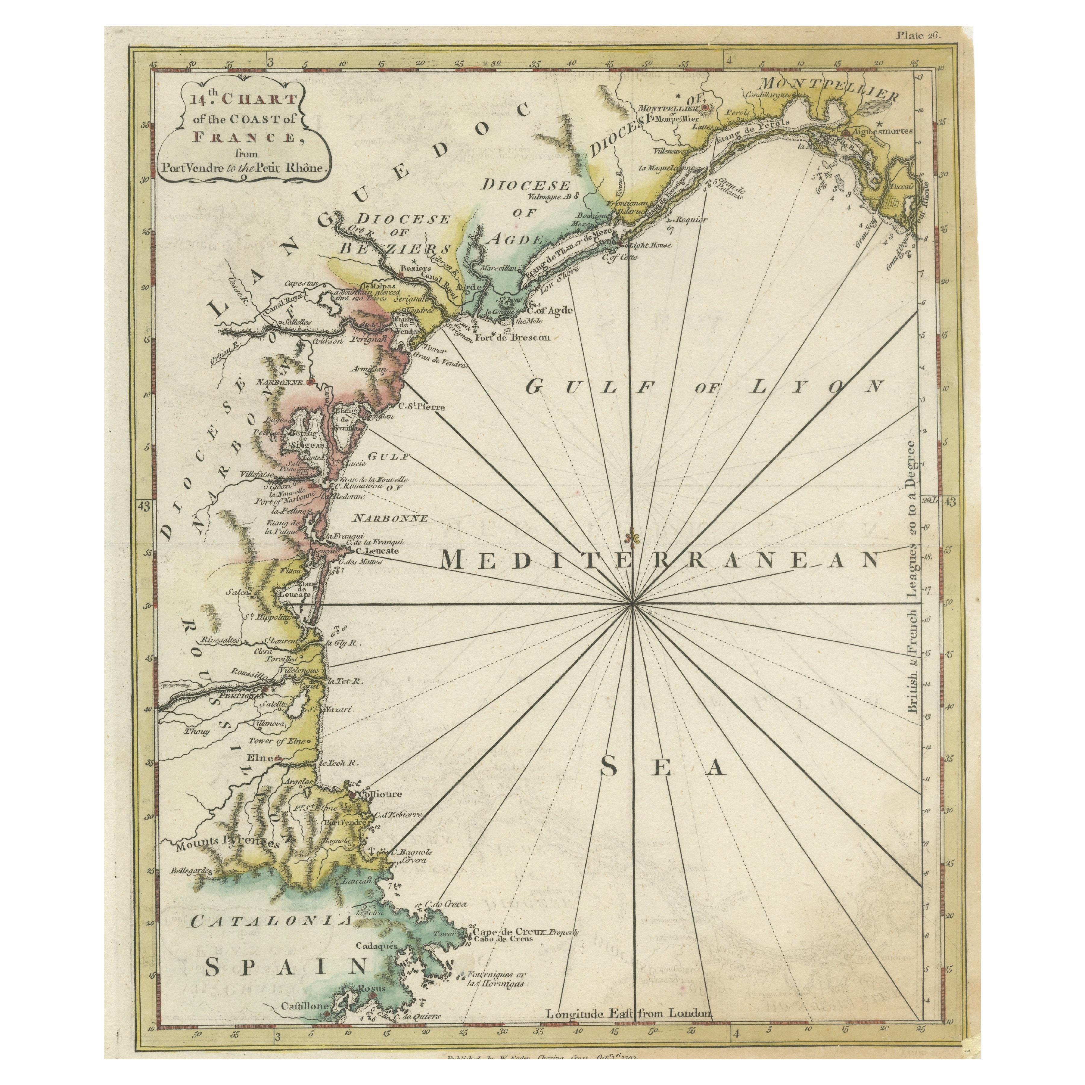
View AllAntique Map of the Coast of Southern France, 1793
Located in Langweer, NL
Antique map titled '14th Chart of the Coast of France, from Port Vendres to the Petit Rhône'. Original map with later hand coroling of the coast of Southern France.
The "14th Chart of the Coast of France, from Port Vendres to the Petit Rhône" is an antique map that offers a detailed depiction of the southern coast of France, specifically highlighting the Mediterranean coastline. This map, which dates back to 1793, was originally part of "Le Petit Neptune Français; Or, French Coasting Pilot," a publication designed for maritime navigation along the French coastlines.
Key Features of the Map:
1. **Geographic Coverage**:
- The map covers the southern French coastline from Port Vendres in the west to the Petit Rhône in the east.
- It includes notable regions such as Languedoc, the Gulf of Lyon, and parts of Catalonia (Spain).
2. **Notable Places**:
- **Montpellier**: A major city in the Diocese of Montpellier, an important cultural and economic center.
- **Narbonne**: Located in the Diocese of Narbonne, a historical city with Roman heritage.
- **Agde**: Situated in the Diocese of Agde, known for its ancient Greek colony origins.
- **Béziers**: Part of the Diocese of Béziers, another city with deep historical roots dating back to Roman times.
- **Port Vendres**: A critical port near the Spanish border.
- **Catalonia**: Including parts of northeastern Spain, emphasizing the coastal connection between France and Spain.
3. **Dioceses and Regions**:
- The map is marked with various dioceses such as Montpellier, Agde, Narbonne, and Béziers, indicating ecclesiastical boundaries.
- It highlights the broader region of Languedoc, a historical province known for its wine production and medieval history.
4. **Navigational Aids**:
- The map features a compass rose with radiating lines, a common navigational aid in maritime maps...
Category
Antique Late 18th Century Maps
Materials
Paper

$227 Sale Price
20% Off
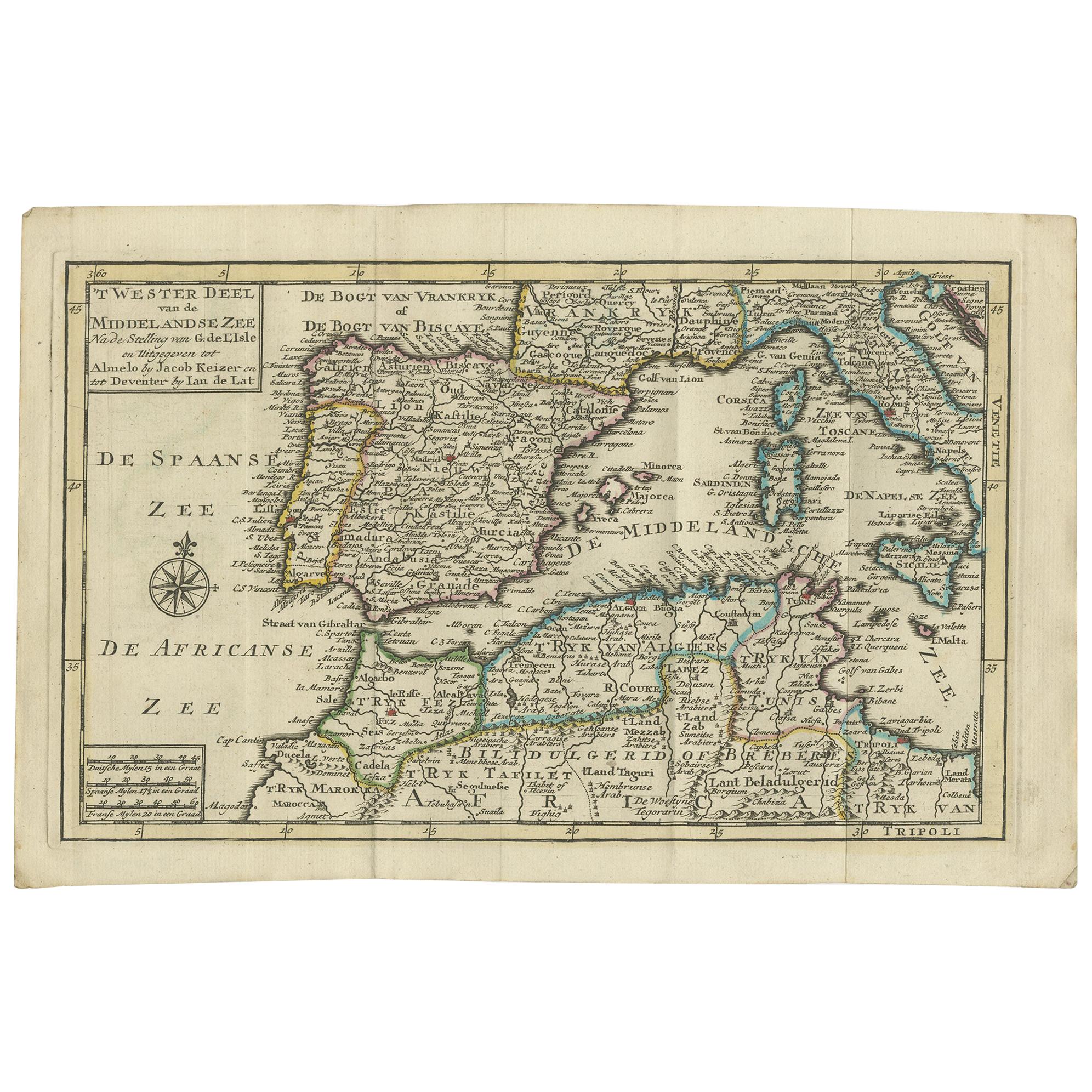
Antique Map of the Mediterranean Sea and Surroundings by Keizer & de Lat, 1788
Located in Langweer, NL
Antique map titled 't Wester Deel van de Middelandse Zee (..)'. Uncommon original antique map of the Mediterranean Sea and surroundings. This map originates from 'Nieuwe Natuur- Gesc...
Category
Antique Late 18th Century Maps
Materials
Paper

$332 Sale Price
20% Off
Original Antique Map of Northern Africa by Van Dùren (1749)
Located in Langweer, NL
This is a German antique map titled 'Neue Geographische Vorstellung der Mitternaechtlichen Küste von Africa'. Original antique engraving of Northern Africa extending from the Strait ...
Category
Antique Mid-18th Century Maps
Materials
Paper

$332 Sale Price
20% Off
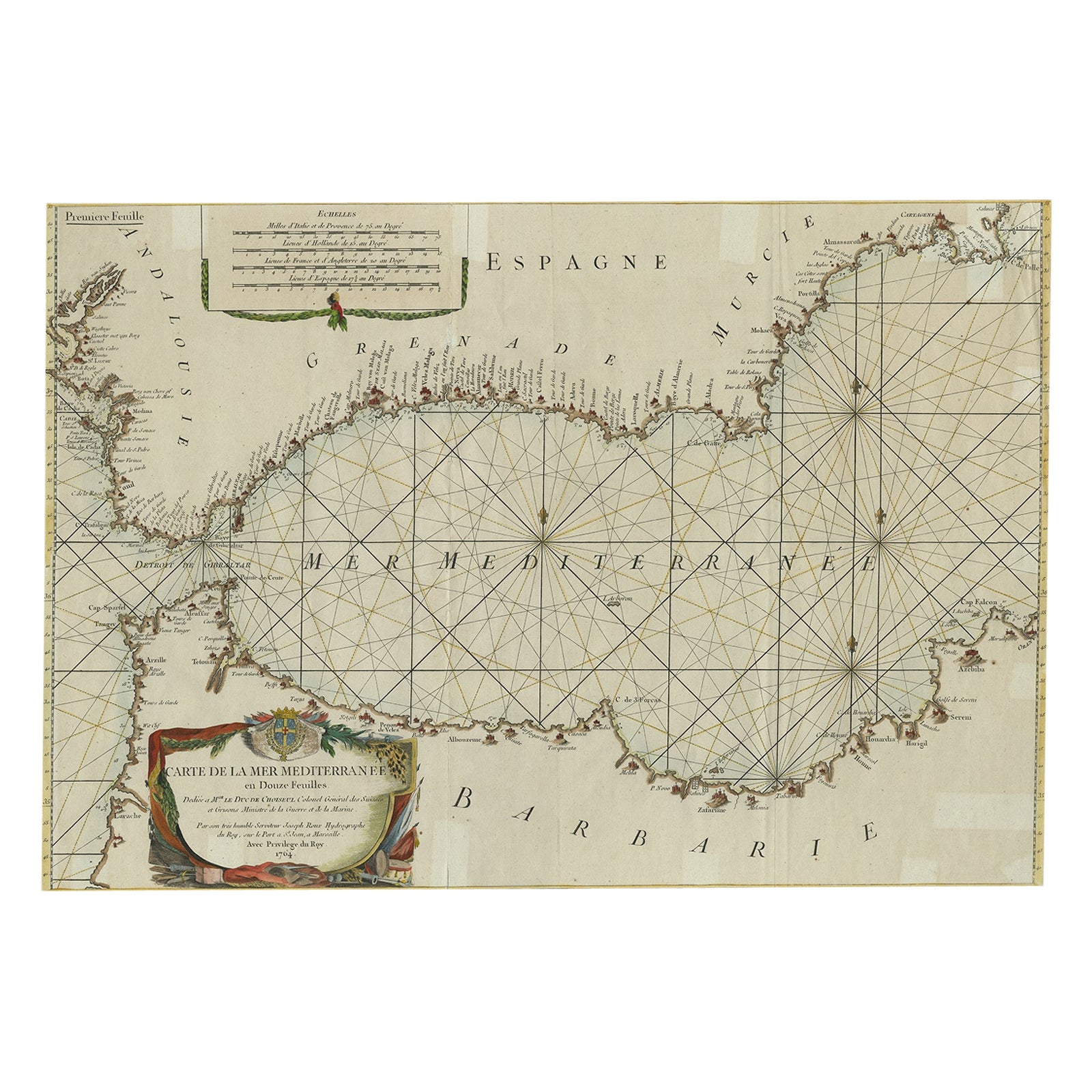
Large Decorative Antique Map of the Mediterranean, ca.1770
Located in Langweer, NL
Antique map titled 'Carte de la Mer Mediterranee en Douze Feuilles'.
First map out of twelve fine engraved double-page and folding maps that join to create a large wall map...
Category
Antique 1770s Maps
Materials
Paper
$1,081 Sale Price
20% Off
Antique Map of the Northern Coast of Africa and Southern Europe, circa 1745
By Covens & Mortier
Located in Langweer, NL
Antique map titled 'In Notitiam Ecclesiasticam Africae Tabula Geographica'. Very decorative hand-colored map of the northern coast of Africa, Spain, Italy and the Mediterranean with the islands of Sardinia, Corsica, Majorca, Minorca etc. Sicily features a smoking Mount Aetna. Embellished with three architectural cartouches...
Category
Antique Mid-18th Century Maps
Materials
Paper

$303 Sale Price
67% Off
Antique Map of Islands in the Mediterranean by Bowen, 'c.1760'
Located in Langweer, NL
Antique map titled 'Particular Draughts of some of the chief African Islands (..)'. Eight small maps on one sheet including 'Islands of Malta Goze & Cuming, An Accurate Chart of Cape de Verde Islands…, Island of St Helena.., Island of Madera, Island of Teneriffe, The Bay of Agoa…, The Dutch Fort at the Cape of Good Hope…, A Draught of Table Bay...
Category
Antique Mid-18th Century Maps
Materials
Paper

$474 Sale Price
20% Off
You May Also Like
West Coast of Africa, Guinea & Sierra Leone: An 18th Century Map by Bellin
By Jacques-Nicolas Bellin
Located in Alamo, CA
Jacques Bellin's copper-plate map entitled "Partie de la Coste de Guinee Dupuis la Riviere de Sierra Leona Jusquau Cap das Palmas", depicting the coast of Guinea and Sierra Leone in ...
Category
Antique Mid-18th Century French Maps
Materials
Paper

Original Antique Map of South America. C.1780
Located in St Annes, Lancashire
Great map of South America
Copper-plate engraving
Published C.1780
Two small worm holes to left side of map
Unframed.
Category
Antique Early 1800s English Georgian Maps
Materials
Paper

Southern Greece: A Large 17th C. Hand-colored Map by Sanson and Jaillot
By Nicolas Sanson
Located in Alamo, CA
This large original hand-colored copperplate engraved map of southern Greece and the Pelopponese Peninsula entitled "La Moree Et Les Isles De Zante, Cefalonie, Ste. Marie, Cerigo & C...
Category
Antique 1690s French Maps
Materials
Paper

1718 Ides & Witsen Map "Route D'amsterdam a Moscow Et De La Ispahan Et Gamron
Located in Norton, MA
1718 Ides & Witsen map, entitled
"Route D'Amsterdam A Moscow Et De La Ispahan Et Gamron,"
Ric.b005
Subject: Eastern Europe and Central Asia
Period: 1718 (published)
Publicati...
Category
Antique Early 18th Century Dutch Maps
Materials
Paper

Mediterranean and Adriatic Seas: Original 18th Century Hand-colored Map by Bowen
Located in Alamo, CA
This is an original 18th century hand-colored map entitled "An Accurate Chart of The Mediterranean and Adriatic Sea's; with the Archipelago & Part of the Black Sea. Exhibiting all th...
Category
Mid-18th Century Old Masters Landscape Prints
Materials
Engraving

Hand-Colored 18th Century Homann Map of Denmark and Islands in the Baltic Sea
By Johann Baptist Homann
Located in Alamo, CA
An 18th century copper plate hand-colored map entitled "Insulae Danicae in Mari Balthico Sitae utpote Zeelandia, Fionia, Langelandia, Lalandia, Falstria, Fembria Mona" created by Joh...
Category
Antique Early 18th Century German Maps
Materials
Paper

More Ways To Browse
Mediterranean Antique
Mediterranean Door
Van Der Zee
World Map Of Trade Routes
Albanian Antique
Antique Furniture Wiltshire
Antique Maps Of Israel
Framed Africa Maps
Antique Furniture Goa
Croatian Antiques
Map Of Israel
Teak Sphere
18th Century Scottish Collectibles
Map Of Mexican California
Ottoman Map
Antique Map Of Korea
Maps South East Asia
Antique Furniture Kansas City