Items Similar to Old Map Guiana, Columbia Venezuela, Andalusia in South America by Bonne, c.1780


Want more images or videos?
Request additional images or videos from the seller
1 of 5
Old Map Guiana, Columbia Venezuela, Andalusia in South America by Bonne, c.1780
$271.67
£204.12
€230
CA$374.09
A$418.68
CHF 219.16
MX$5,086.18
NOK 2,782.82
SEK 2,626.06
DKK 1,750.53
About the Item
Antique map titled 'Carte du Nouv. Rme. de Grenade, de la Nou'le Andalousie, et de la Guyane, avec les pays Limitrophes qui en sont au sud'.
Detailed map covering part of South America including Colombia, Ecuador, Venezuela and Guayana. Originates from G. Raynal's 'Atlas de toutes les parties du Globe Terrestre (..)'. Artists and Engravers: Drawn by R. Bonne.
Artist: Drawn by R. Bonne.
Antique prints have long been appreciated for both their aesthetic and investment value. They were the product of engraved, etched or lithographed plates. These plates were handmade out of wood or metal, which required an incredible level of skill, patience and craftsmanship. Whether you have a house with Victorian furniture or more contemporary decor an old engraving can enhance your living space.
- Dimensions:Height: 10.24 in (26 cm)Width: 15.16 in (38.5 cm)Depth: 0 in (0.01 mm)
- Materials and Techniques:
- Period:
- Date of Manufacture:circa 1780
- Condition:Condition: Good, small defect upper part of the map. General age-related toning, please study image carefully.
- Seller Location:Langweer, NL
- Reference Number:Seller: BGI-007111stDibs: LU3054327621752
About the Seller
5.0
Recognized Seller
These prestigious sellers are industry leaders and represent the highest echelon for item quality and design.
Platinum Seller
Premium sellers with a 4.7+ rating and 24-hour response times
Established in 2009
1stDibs seller since 2017
2,534 sales on 1stDibs
Typical response time: <1 hour
- ShippingRetrieving quote...Shipping from: Langweer, Netherlands
- Return Policy
Authenticity Guarantee
In the unlikely event there’s an issue with an item’s authenticity, contact us within 1 year for a full refund. DetailsMoney-Back Guarantee
If your item is not as described, is damaged in transit, or does not arrive, contact us within 7 days for a full refund. Details24-Hour Cancellation
You have a 24-hour grace period in which to reconsider your purchase, with no questions asked.Vetted Professional Sellers
Our world-class sellers must adhere to strict standards for service and quality, maintaining the integrity of our listings.Price-Match Guarantee
If you find that a seller listed the same item for a lower price elsewhere, we’ll match it.Trusted Global Delivery
Our best-in-class carrier network provides specialized shipping options worldwide, including custom delivery.More From This Seller
View AllAntique Map of South America Depicting Guayana, c.1780
Located in Langweer, NL
Antique map titled 'La Guyane Francopise avec partie de la Guyane Hollandoise: suivant les Operations et les Cartes recentes des Ingenieurs-Geographes Francois'. Antique map of South...
Category
Antique 18th Century Maps
Materials
Paper

$330 Sale Price
20% Off
Authentic Antique Map of the Caribbean, Gulf Coast and Central America, 1787
Located in Langweer, NL
Antique map titled 'Les Isles Antilles et le Golfe du Méxique'. Original old map of the Caribbean, Gulf Coast and Central America. With inset map of Bermuda...
Category
Antique Late 18th Century Maps
Materials
Paper

$292 Sale Price
20% Off
Free Shipping
Antique Map of Northern Brazil by Bonne, c.1780
Located in Langweer, NL
Antique map titled 'Carte de la Partie Septentrionale du Bresil.' Detailed map of the northern portion of Brazil from Bahia to French Guiana, showing the eastern Amazon interior rivers, Mission Territories, Goyza and the coastal regions, including coastal currents. Source unknown, to be determined. Artists and Engravers: Rigobert Bonne (1727-1795 ) was one of the most important cartographers of the late 18th century. In 1773 he succeeded Jacques Bellin as Royal Cartographer to France in the office of the Hydrographer at the Depôt de la Marine. Working in his official capacity Bonne compiled some of the most detailed and accurate maps of the period. Bonne's work represents an important step in the evolution of the cartographic ideology away from the decorative work of the 17th and early 18th century towards a more detail oriented and practical aesthetic. With regard to the rendering of terrain Bonne maps...
Category
Antique 18th Century Maps
Materials
Paper

$118 Sale Price
20% Off
Antique Map of South America by J. Cook, 1775
Located in Langweer, NL
Antique map titled 'Kaart van het Zuidlyk Eind van Amerika'. Map of the sourthern part of South America, focusing on Cook's tracks around the Cape Horn and T...
Category
Antique Mid-18th Century Maps
Materials
Paper

$803 Sale Price
20% Off
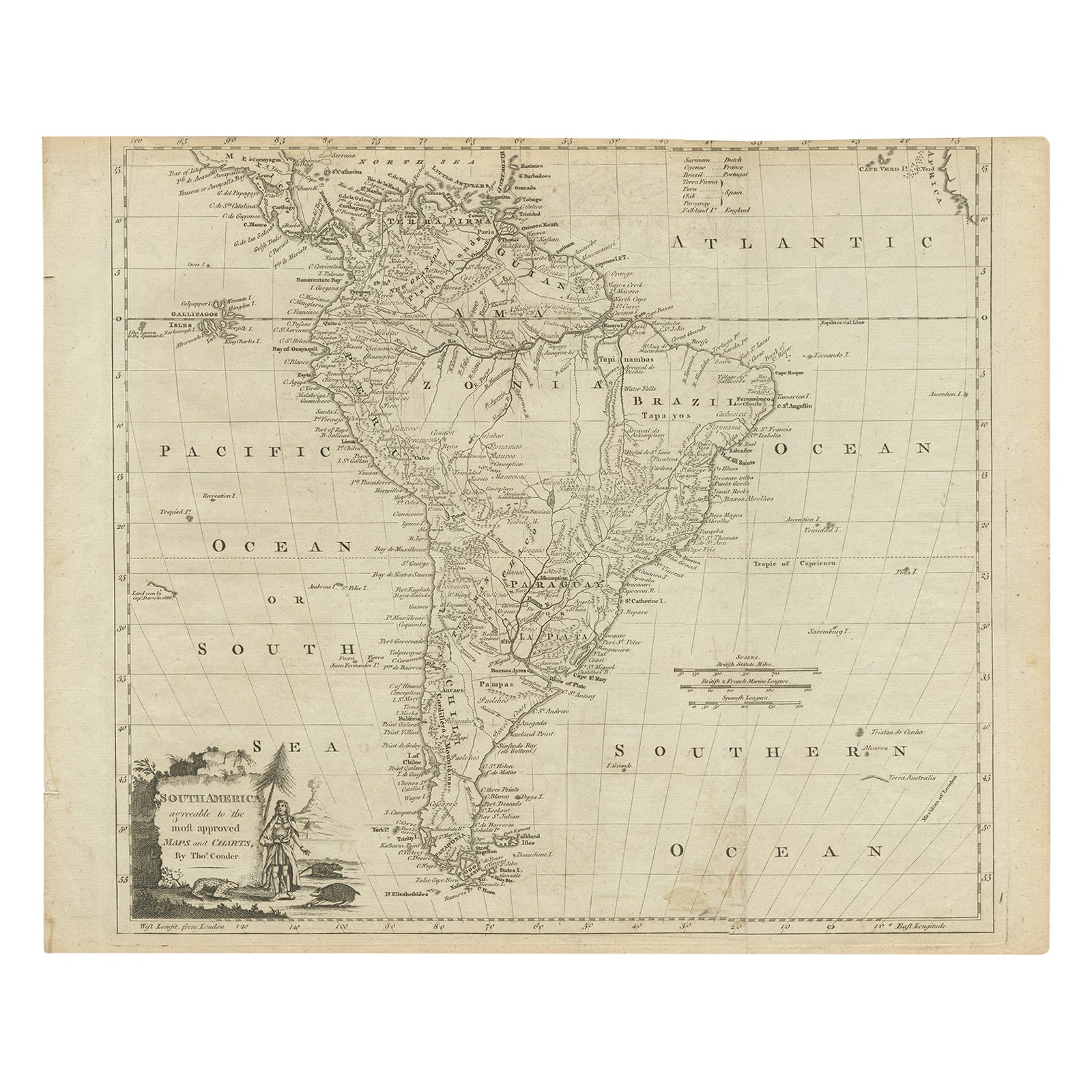
Antique Map of South America by Conder, c.1775
Located in Langweer, NL
Antique map titled 'South America agreeable to the most approved maps and charts'. Rare map of South America depicting Chili, La Plata, Paraguay, Brazil, Peru, the Amazon and surroun...
Category
Antique 18th Century Maps
Materials
Paper

$327 Sale Price
20% Off
Rare Map of South America of Chili, La Plata, Paraguay, Brazil, Peru, c.1775
Located in Langweer, NL
Antique map titled 'South America agreeable to the most approved maps and charts'.
Rare map of South America depicting Chili, La Plata, Paraguay, Brazil, ...
Category
Antique 1770s Maps
Materials
Paper

$510 Sale Price
20% Off
You May Also Like
Original Antique Map of South America. C.1780
Located in St Annes, Lancashire
Great map of South America
Copper-plate engraving
Published C.1780
Two small worm holes to left side of map
Unframed.
Category
Antique Early 1800s English Georgian Maps
Materials
Paper

Original Antique Map of Central America / Florida, Arrowsmith, 1820
Located in St Annes, Lancashire
Great map of Central America.
Drawn under the direction of Arrowsmith.
Copper-plate engraving.
Published by Longman, Hurst, Rees, Orme and Brown, 1820
Unframed.
Category
Antique 1820s English Maps
Materials
Paper

The Americas - Vintage Map - 18th century
Located in Roma, IT
The Americas is a very beautiful vintage map realized in the 18th century by an Italian cartographer.
Very good conditions, on the right side the inscript...
Category
18th Century Figurative Prints
Materials
Paper, Etching

Antique French Map of Asia Including China Indoneseia India, 1783
Located in Amsterdam, Noord Holland
Very nice map of Asia. 1783 Dedie au Roy.
Additional information:
Country of Manufacturing: Europe
Period: 18th century Qing (1661 - 1912)
Condition: Overall Condition B (Good Used)...
Category
Antique 18th Century European Maps
Materials
Paper

$648 Sale Price
20% Off
1654 Joan Blaeu Map the Sutherland, Scotland, Entitled "Southerlandia, "Ric0007
Located in Norton, MA
1654 Joan Blaeu map of the
Sutherland, Scotland, entitled
"Southerlandia,"
Hand Colored
Ric0007
Description:
Lovely map centered on Sedan and D...
Category
Antique 17th Century Dutch Maps
Materials
Paper

1627 Hendrik Hondius Map Entitled "Vltoniae Orientalis Pars, " Ric.a009
Located in Norton, MA
1627 Hendrik Hondius map entitled
"Vltoniae orientalis pars,"
Ric.a009
Title:
Vltoniae orientalis : pars
Title (alt.) :
Ultoniae orientalis pars
Creator:
Mercator, Gerh...
Category
Antique 17th Century Dutch Maps
Materials
Paper

More Ways To Browse
Antique Grenade
Antique Map Of Colombia
John Speed Antique Maps
Malaysia Map
Sebastian Munster
Antique Map Chile
Antique Map Of Boston
Ipswich Antique Furniture
Maps Balkans
Missouri Map
Antique Maps Of Texas
Antique Maps Virginia
Antique Railroad Scale
Jamaican Antique
Hindeloopen Furniture
Romania Map
Stanford Antique Furniture
Sardinia Map