Items Similar to Original Antique Bird's-Eye View of Colmar, Alsace, France, 1552
Want more images or videos?
Request additional images or videos from the seller
1 of 5
Original Antique Bird's-Eye View of Colmar, Alsace, France, 1552
$615.22
$769.0320% Off
£463.99
£579.9920% Off
€528
€66020% Off
CA$850.60
CA$1,063.2520% Off
A$952.81
A$1,191.0220% Off
CHF 500.45
CHF 625.5620% Off
MX$11,585.89
MX$14,482.3620% Off
NOK 6,337.35
NOK 7,921.6820% Off
SEK 6,015.85
SEK 7,519.8120% Off
DKK 4,019.48
DKK 5,024.3520% Off
About the Item
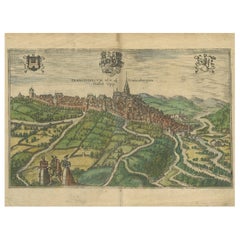
Antique map titled 'La Paincture de la cité de Colmar & du pais circonuoisin'.
Original antique bird's-eye view of Colmar, Alsace, France. This map originates from 'La Cosmographie Universelle' by S. Münster. Published 1552.
Artists and Engravers: Sebastian Münster (1488-1552) was a cosmographer and professor of Hebrew who taught at Tübingen, Heidelberg, and Basel. He settled in the latter in 1529 and died there, of plague, in 1552. Münster made himself the center of a large network of scholars from whom he obtained geographic descriptions, maps, and directions.
- Dimensions:Height: 12.41 in (31.5 cm)Width: 15.16 in (38.5 cm)Depth: 0 in (0.02 mm)
- Materials and Techniques:
- Period:
- Date of Manufacture:1552
- Condition:Wear consistent with age and use. Condition: Good, general age-related toning. Original folding line. Minor wear/creasing, French text on verso. Please study image carefully.
- Seller Location:Langweer, NL
- Reference Number:Seller: BG-12834-21stDibs: LU3054327311622
About the Seller
5.0
Recognized Seller
These prestigious sellers are industry leaders and represent the highest echelon for item quality and design.
Platinum Seller
Premium sellers with a 4.7+ rating and 24-hour response times
Established in 2009
1stDibs seller since 2017
2,517 sales on 1stDibs
Typical response time: <1 hour
- ShippingRetrieving quote...Shipping from: Langweer, Netherlands
- Return Policy
Authenticity Guarantee
In the unlikely event there’s an issue with an item’s authenticity, contact us within 1 year for a full refund. DetailsMoney-Back Guarantee
If your item is not as described, is damaged in transit, or does not arrive, contact us within 7 days for a full refund. Details24-Hour Cancellation
You have a 24-hour grace period in which to reconsider your purchase, with no questions asked.Vetted Professional Sellers
Our world-class sellers must adhere to strict standards for service and quality, maintaining the integrity of our listings.Price-Match Guarantee
If you find that a seller listed the same item for a lower price elsewhere, we’ll match it.Trusted Global Delivery
Our best-in-class carrier network provides specialized shipping options worldwide, including custom delivery.More From This Seller
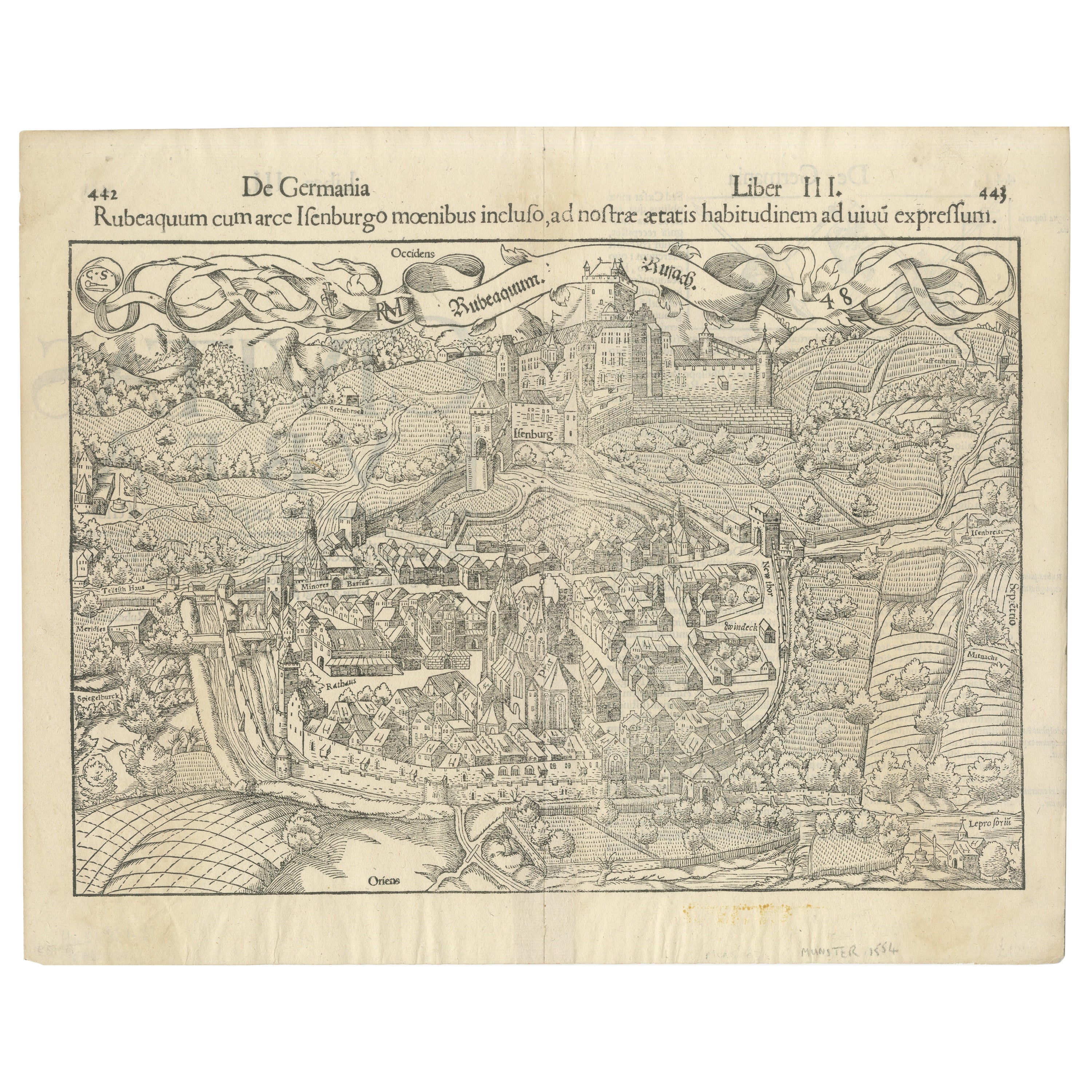
View AllEarly Woodcut Bird's Eye View of Rouffach, France, by Sebastian Münster, 1554
Located in Langweer, NL
Early Woodcut Bird's Eye View of Rouffach, France, by Sebastian Münster, 1554
Description: This rare 1554 woodcut is a bird's eye view of Rouffach, a town in the Haut-Rhin departmen...
Category
Antique 16th Century Maps
Materials
Paper
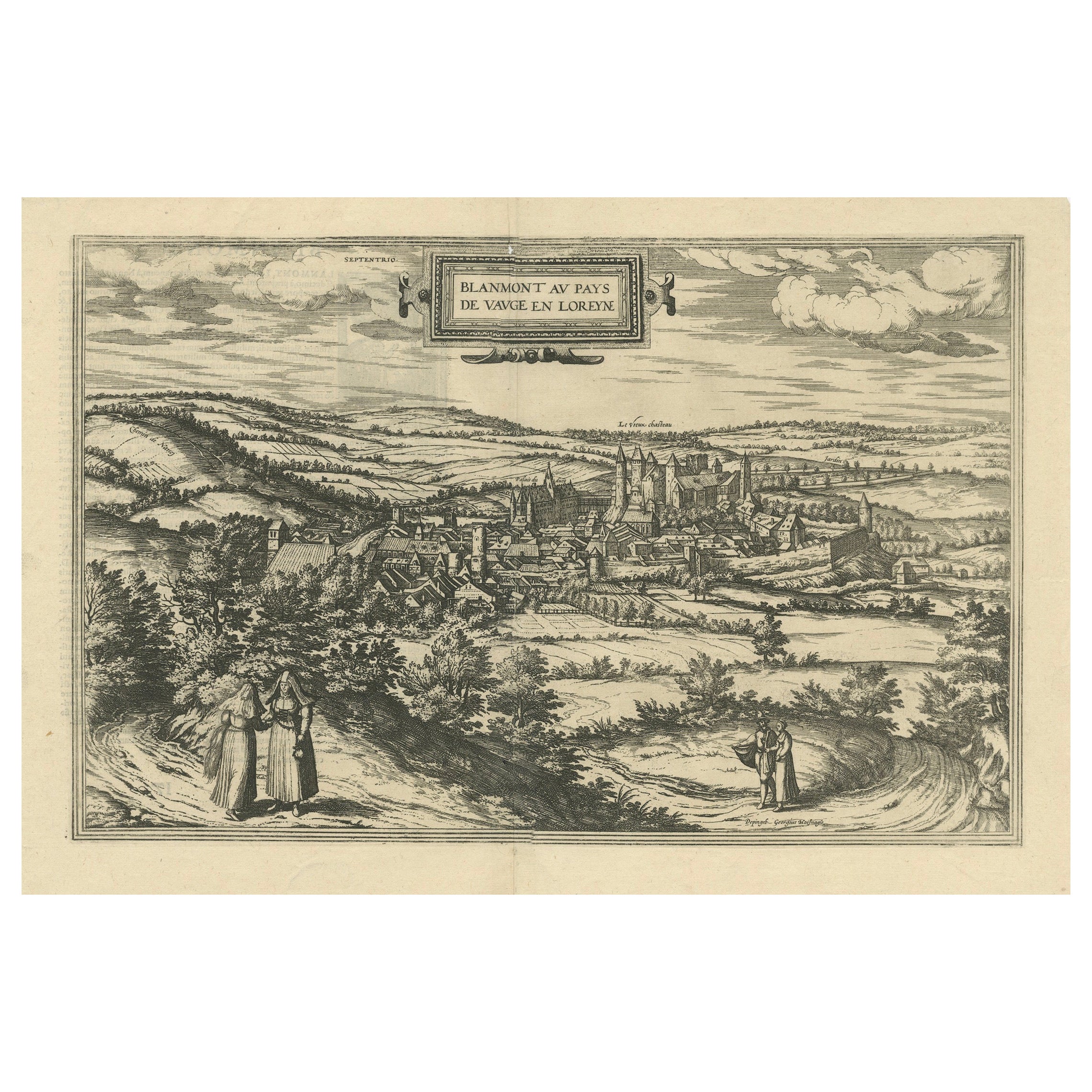
Bird's-Eye View of Blâmont in Lorraine by Braun and Hogenberg, 1597
Located in Langweer, NL
Title: Bird's-Eye View of Blâmont in Lorraine by Braun and Hogenberg, 1597
This copperplate engraving, published in 1597 by Braun and Hogenberg, depicts a bird's-eye view of the t...
Category
Antique 16th Century Maps
Materials
Paper
$391 Sale Price
30% Off
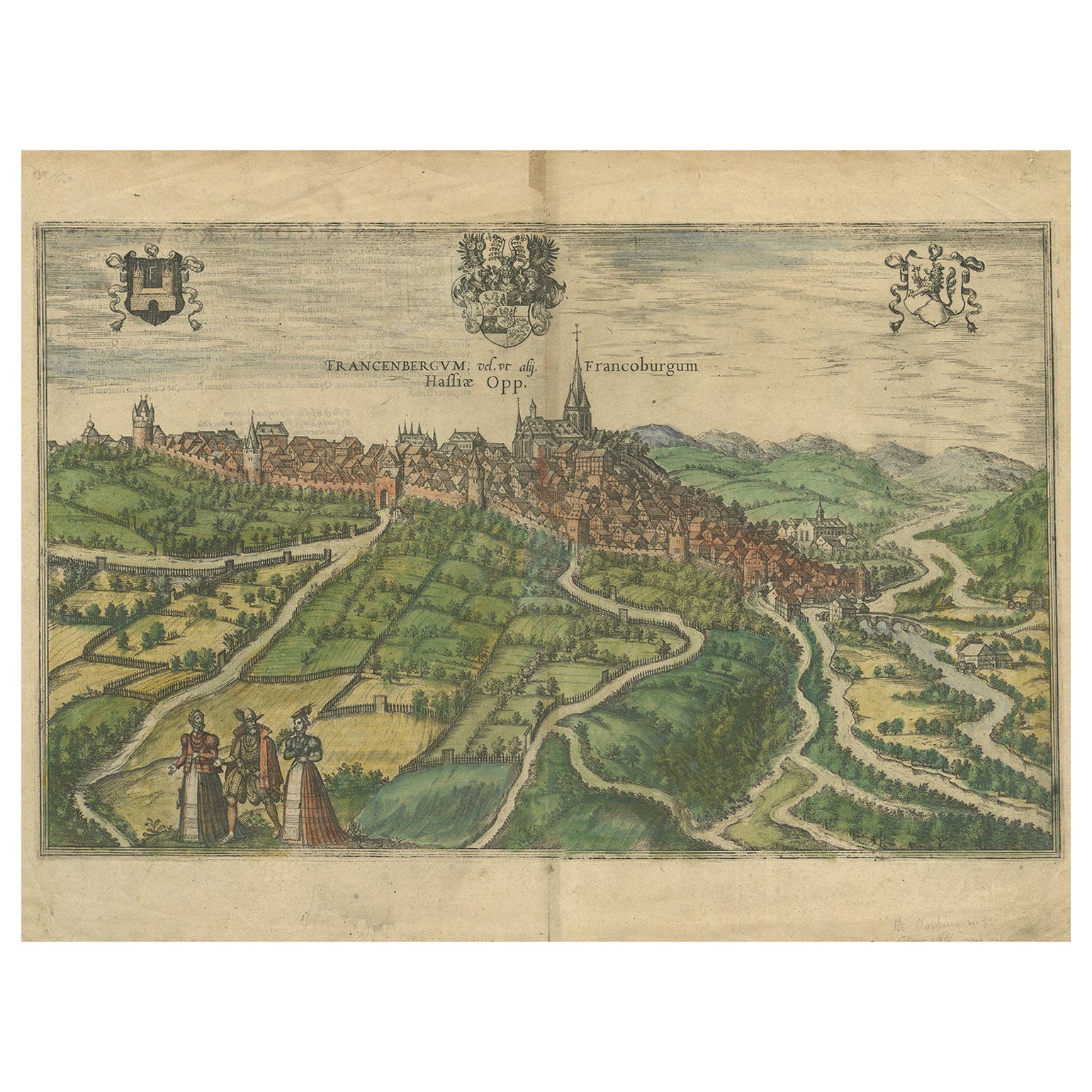
View of Frankenberg: Braun & Hogenberg's Historic Bird's-Eye Map, 1599
Located in Langweer, NL
The antique print titled 'Francenbergum, vel ut alij Francoburgum Hassiae Opp', published by Braun & Hogenberg around 1599, is a remarkable historical ...
Category
Antique 16th Century Prints
Materials
Paper
$466 Sale Price
20% Off
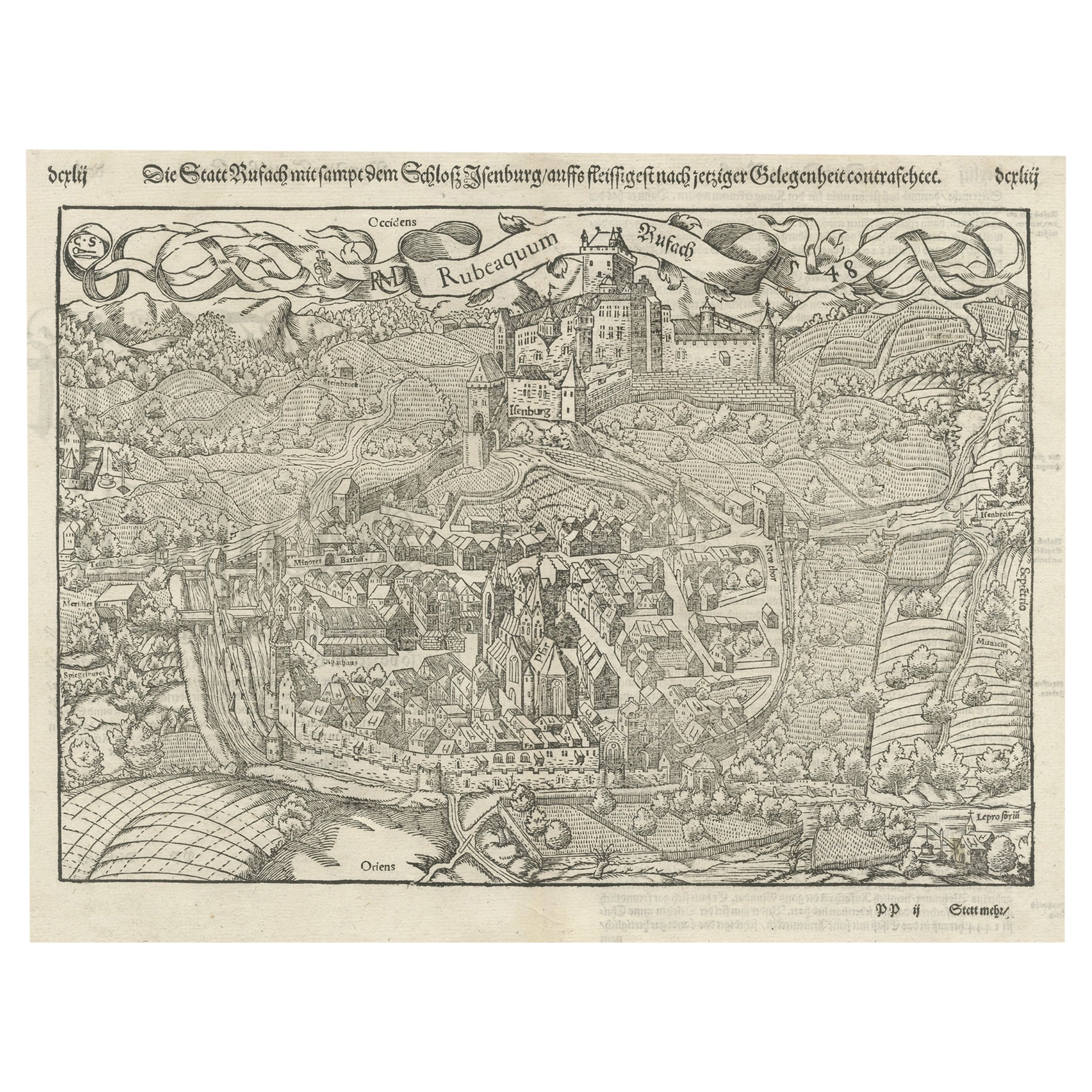
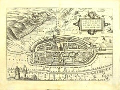
Original Antique Plan of Rouffach, France, with Chateau d'Isenbourgh, 1588
Located in Langweer, NL
Antique map titled 'Die Statt Rufach mit sampt dem Schloss Isenburg (..)'.
Original antique bird's-eye view plan of Rouffach, France, with Chateau d'Isenbourg. This map originate...
Category
Antique 16th Century Maps
Materials
Paper
$447 Sale Price
20% Off
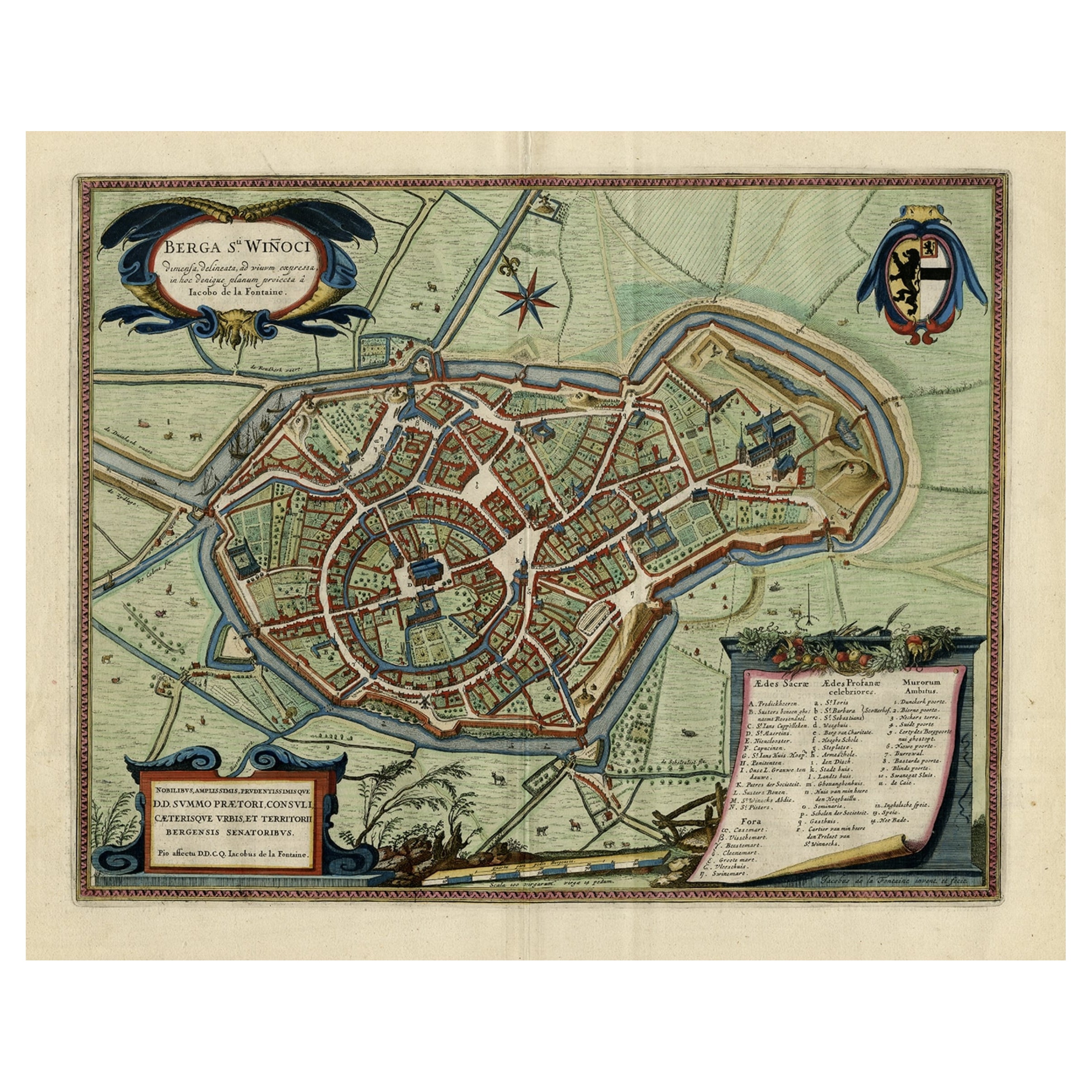
Original Old Bird's-Eye View Plan of Sint-Winoksbergen or Bergen in France, 1649
Located in Langweer, NL
Antique map titled 'Berga Sti Winoci.' - Bird's-eye view plan of Sint-Winoksbergen in France, with key to locations and coats of arms. Text in Dutch on verso. This plan originates from the famous city Atlas: 'Toneel der Steeden' published by Joan Blaeu...
Category
Antique 1640s Maps
Materials
Paper
$1,351 Sale Price
20% Off
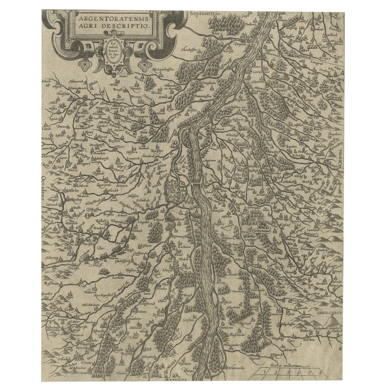
Original Antique Map of the Rhine, South and North of Strasbourg, Germany, 1608
Located in Langweer, NL
Antique map titled 'Argentoratensis agri descriptio'.
Original antique map of the Rhine, both south and north of Strasbourg, based on Daniel Specklin's three-sheet map of the Elz...
Category
Antique Early 1600s Maps
Materials
Paper
$298 Sale Price
20% Off
You May Also Like
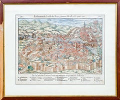
Antique Map of The City of Rome by Sebastian Münster, 1549
By Sebastian Münster
Located in New York, NY
Sebastian Münster (German, 1488-1552)
LA SITUATION DE LA VILLE DE ROME
Antique Map of Rome, 1549
Possibly printed in 1964
Print on paper
Publisher:...
Category
1960s Realist Figurative Prints
Materials
Woodcut
Old Engraving Map of Paris French Munster 16th Century Walled City Framed
Located in Wilton, CT
Old or antique colored engraving of Munster's 1572 map of Paris, circa 19th or 20th century (Frame was not opened to look for a publication ...
Category
20th Century French Renaissance Prints
Materials
Paper
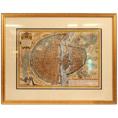
$950 Sale Price
36% Off
Vienna, Austria: A Large 17th Century Hand-Colored Map by Sanson and Jaillot
By Nicolas Sanson
Located in Alamo, CA
This large 17th century hand-colored map of Vienna, Austria and the surrounding countryside and villages entitled "Plan de la Ville de Vienne en Austrich...
Category
Antique 1690s French Maps
Materials
Paper

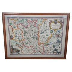
Vintage 20th Century Engraving of a Map of Duchy of Burgundy and County - 2Y442
Located in Bordeaux, FR
This vintage 20th-century engraving features a detailed map of the Duchy of Burgundy and the County of Bresse, making it an elegant and historical addition to any collection. Measuri...
Category
20th Century Antiquities
Materials
Wood, Paper
Map of Kalkar - Etching by G. Braun and F. Hogenberg - Late 16th Century
By Franz Hogenberg
Located in Roma, IT
This map of Calcaria is an original etching realized by George Braun and Franz Hogenberg, as part of the famous Series "Civitates Orbis Terrarum" (Atlas of the Cities of the World)....
Category
16th Century Figurative Prints
Materials
Etching
1590 Ortelius Map of Calais and Vermandois, France and Vicinity Ric.a014
Located in Norton, MA
1590 Ortelius map of
Calais and Vermandois, France and Vicinity
Ric.a014
Two rare regional Abraham Ortelius maps on a single folio sheet. Left map, entitled Caletensium, depic...
Category
Antique 16th Century Dutch Maps
Materials
Paper

More Ways To Browse
16th Century Antiques
Sebastian Munster
Ptolemy Map
Map Of Jerusalem
1820 World Map
Cyprus Antique Maps
Antique Ecuador
Antique Map Of Thailand
Antique Mississippi Map
Antique Ohio Maps
Burgundy Map
John Speed Maps
Antique Map Of Turkish Empire
Antique Portuguese Scales
Canadian Atlas Furniture
Prussia Map
Afghanistan Map
Malabar Map